FISC - St. Petersburg
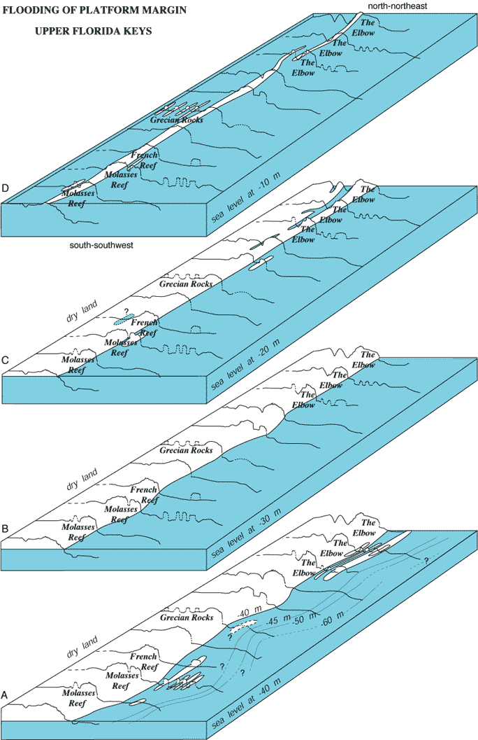
Figure 112. Block diagrams of the Pleistocene shelf-edge surface off the upper Keys are constructed from outlines of pre-1997 interpreted seismic profiles (Figs. 90, 91A; blocks at same scale as in Fig. 111; from Lidz et al., 1997b). (A-D) Diagrams show reef-and-trough system and geomorphic changes during Holocene sea-level rise. Distance between profiles is not to scale. Distance along margin between end profiles is ~10 km. Shelf-edge morphologies changed rapidly from a discontinuous series of linear, low-relief terrace islands, possibly dune ridges with wide, shallow, intervening lagoons, to no emergent features. Holocene sediments now bury the ridges and lagoonal areas. Note when sea level was 20 m lower than present (C), water filled a linear embayment formed by a backreef trough behind The Elbow, an offset reef along the emergent shelf-edge reef (Lidz et al., 1997a; see Bedrock Surface map). Also note fork in embayment (C), where margin reentrant, when flooded, would isolate the reef. Crest of shelf-edge reef is higher than the shelf, indicating presence of a rock-island barrier when sea level was <10 m below present. Note islands once existed at Grecian Rocks.
|
Can't see the printable PDF version? Get the free Adobe Acrobat® Reader. |

![]() U.S. Department of the Interior |
U.S. Geological Survey
U.S. Department of the Interior |
U.S. Geological Survey
URL: [disc] /pubs/pp/2007/1751/professional-paper/tile7-8/figures/fig112.html
Page Contact Information: Feedback
Page Last Modified: December 01, 2016 @ 04:14 PM (JSS)
