PRE-1980 TEPHRA-FALL DEPOSITS ERUPTED FROM MOUNT ST. HELENS, WASHINGTON
By Donal R. Mullineaux
U. S. Geological Survey Professional Paper 1563
Tephra Set X
Set X consists chiefly of multiple layers of scoriaceous ash that form a
dark, fine-grained stratigraphic unit (fig. 64) that crops out all around the volcano.
It is conspicuously darker and finer grained than either the underlying set W and or the overlying layer T (fig. 64). Of the four layers identified in the set (fig. 65),
only the basal layer contains lapilli or bombs. The set is unweathered except for a slight oxidation zone at its
top.
|
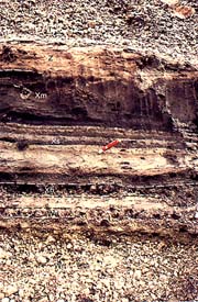
Figure 64. Dark, fine-grained tephra set X between the coarse, pumiceous set W and layer T, about 5 km
northeast of the center of Mount St. Helens. Pocketknife shown for scale. Photograph taken in 1983. (138K)
|
Set X tephras commonly are interbedded with pyroclastic-flow deposits and other
deposits of flowage origin southwest of the volcano, and specific tephra layers were not identified there.
|

Figure 65. Composite columnar section of tephra set X, Mount St. Helens, showing approximate thicknesses
5 km northeast of volcano center. (11K)
|
Composition
Most clasts in set X are vesicular, but denser fragments are also abundant.
Although the set is mostly andesite or basaltic andesite, dacite is present as clots and bands in the scoria (Pallister
and Hoblitt, 1985; Pallister and others, 1992, p. 134). Ferromagnesian mineral suites of all layers contain olivine,
hypersthene, and augite in various proportions (table 6). Some hypersthene crystals in the
lower part of the set have relatively high refractive indexes similar to those in set W; the few hypersthenes examined
from the upper part of the set do not. Whole-rock samples from each of three layers contain between about 55 and
60 percent SiO2.
Diagnostic features
Except for set B, set X is readily distinguished from all other Mount St.
Helens tephras by its dark color, constituent scoria, and abundance of olivine. It generally can be distinguished
from scoriaceous layers of set B by finer grain size, absence of strong oxidation, and stratigraphic position.
In addition, the ferromagnesian mineral suites of set X differ from those in all layers in set B except layer Bo;
distinction from layer Bo can be made on the basis of stratigraphic relations.
Stratigraphic relations
Set X overlies set W without any evident erosional or weathering break;
in some outcrops scattered lapilli at the base of set X lie alongside lapilli of set W in the same stratigraphic
zone. Generally, there is no erosion or other evidence of a time break between the top of set X and the overlying
ash bed z. In places the contact of set X with ash bed z is gradational and in other places interfingered.
Distribution and thickness
Set X is present all around the volcano (fig. 66);
it is thickest and includes the most identified layers north-northeast of the volcano. At 5 km in that direction,
it is about 50 cm thick, but only the basal layer Xb contains clasts larger than ash size. At 20 km toward the
northeast, the set is 5-10 cm thick and consists almost entirely of ash. In other directions, the set is thinner
and also consists entirely or almost entirely of ash.
|
Figure 66. Thickness (in centimeters, large dots) of tephra set X at selected locations, Mount St. Helens.
Isopachs are smoothed from results of study by M. R. Couchman and R. P. Hoblitt (written commun., 1993); small
dots are sites of their data points. (14K)
|
Although thin, the set is an excellent marker near the volcano because it is
readily identifiable by its color and ferromagnesian minerals and it extends in all directions. It is also useful
as a marker for at least several tens of kilometers beyond the volcano. At present, it has been traced farthest
to the east, to a maximum distance of about 50 km.
Origin
Grain size and distribution of set X suggests that its deposition began
with two or more brief eruptions as winds blew from the southwest and west. Those eruptions were followed by less
vigorous but repeated eruptions that produced finer but more voluminous deposits: wind directions during these
latter eruptions varied enough to spread ash on all sides of the volcano.
The presence in set X of dacitic inclusions in mafic fragments, banded clasts,
and hypersthene phenocrysts similar to those in set W suggest that mixing of the two magmas was an important cause
of the eruptions that produced the set (Pallister and Hoblitt, 1985; Pallister and others, 1992). An increase in
proportion of mafic components from the early to mid-set X eruptions is shown by the compositions of layers Xb,
Xs, and Xm.
Age
Set X probably began to accumulate within 30 years after set W eruptions
ceased. Tree-ring studies (Yamaguchi, 1993) indicate that a tree underlain by at least part of set X began to grow
by A.D. 1510.
The time that set X eruptions ended is not closely known. The closest upper
limiting date of A.D. 1647 (Yamaguchi and Hoblitt, 1986) suggests only that the set accumulated in less than about
150 years.
Description of layers in set X
Set X consists of three prominent and one obscure layer (figs.
64, 67, 68; measured section X-1). A coarse, thin basal
stratum that contains lapilli and bombs (layer Xb) is overlain by a conspicuous, bedded ash deposit (layer Xs),
a massive darker ash (layer Xm), and a similar but lighter colored ash (layer Xh) (fig.
64). No evidence of time lapses between the deposition of any of those layers was seen. All layers of the set
are identifiable just northeast and east of the volcano. Only layer Xm, however, was identified toward the west.
|
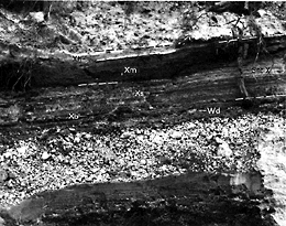
Figure 67. Layering in tephra set X 9 km east of the volcano center, Mount St. Helens. Striped layer
Xs contrasts with dark layer Xm but differs from underlying layer Xb chiefly in grain size. (140K)
|
|
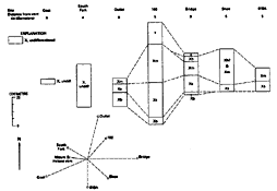
Figure 68. Columnar sections of tephra set X and diagram of their locations relative to Mount St. Helens.
(14K)
|
Measured section X-1
Road cut at west end of bridge that crossed Smith Creek in 1983, in NE1/4 SE1/4
sec. 5, T. 8 N., R. 6 E. See Figure 67.
| |
|
Thickness
(centimeters) |
| 8. |
Flowage deposit, lahar(?) |
75-100 |
| 7. |
Ash bed z; fine, pale pinkish to grayish brown: contact with set X locally distorted and interfingered |
2 |
| Set X |
|
|
| 6. |
Layer Xh. Ash, fine, brownish-gray, gradational, obscure; locally distorted contacts at base and top |
4 |
| 5. |
Layer Xm. Ash, fine to coarse, moderate- to dark-gray, relatively friable: contact
with underlying layer Xs sharp to gradational, locally distorted |
9 |
| 4. |
Layer Xs. Alternating beds of coarse and fine ash, pale- to moderate-grayish-brown |
12 |
| 3. |
Layer Xb. Chiefly ash, brownish-gray: small scoriaceous and dense lapilli as much as about 2 cm across |
1-2 |
| Set W |
|
|
| 2. |
Ash, fine: slightly pinkish gray cast |
2 |
| 1. |
Layer Wd. Dacitic pumiceous and lithic lapilli
and a few small bombs in sparse ash |
2 |
Layer Xb
Layer Xb is a thin layer of lapilli and bombs in sparse ash at the base
of set X (figs. 64, 67). In many places its largest fragments
extend above the surface of the ash matrix. Locally the layer consists of more than one bed, and elsewhere it consists
of only scattered bombs and lapilli rather than a continuous stratum.
Most large clasts in the layer are vesicular, scoriaceous andesite, but some
contain inclusions of dacite that are mineralogically similar to pumice in set W. The ferromagnesian minerals in
layer Xb are hypersthene, olivine, augite, and hornblende (table 6). A few hypersthene phenocrysts
examined had lowest refractive indexes well above 1.70 and thus are similar to hypersthene phenocrysts in set W.
Layer Xb is readily distinguished from underlying and overlying dacitic layers
by dark color and mafic composition and from set B layers by stratigraphic position and ferromagnesian minerals.
It differs from overlying layer Xs by presence of lapilli and bombs.
Layer Xb throughout its extent overlies layer Wd or other layers of set W and
is overlain by younger ash of set X. Lapilli of layer Xb lie alongside clasts of layer Wd in the same stratigraphic
zone in many places. Lapilli and bombs of layer Xb probably fell down between scattered clasts of layer Wd, resulting
in a stratigraphic unit that includes elements of both tephras.
Layer Xb was identified from approximately northeast to east of the volcano.
Its maximum known thickness and its coarsest part lie almost directly to the northeast (fig.
69). At 5 km, it is 5-10 cm thick but contains bombs as large as 10 cm across. Farther northeast, the layer
thins to 4 cm at about 10 km and to 2 cm at about 25 km. East of the volcano, the layer contains lapilli as far
from the volcano as 10 km but is only about 2 cm thick at that distance.
|
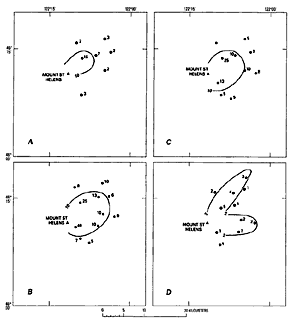
Figure 69. Thickness (in centimeters) of layers in tephra set X, Mount St. Helens, and of the overlying
ash bed z. A, Ash bed z. B, Layer Xm. C, Layer Xs. D, Layer Xb. (14K)
|
Layer Xb probably originated from at least two low-volume eruptions during
times when winds blew from the southwest and northwest. Comparison of its thickness with that of deposits resulting
from minor Mount St. Helens eruptions after May 18, 1980, suggests that the eruptions that produced layer Xb were
short, perhaps lasting only an hour or less.
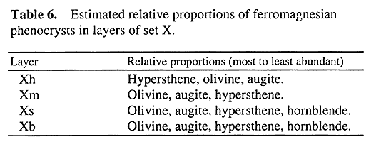
Layer Xs
Layer Xs is a series of at least 10 alternating beds of pale, coarse ash
and dark, finer ash (figs. 64, 67). Changes in grain size
from bed to bed are abrupt, and the fine-grained beds are more coherent. The differences in darkness and coherence
commonly give the layer a banded appearance (figs. 64, 67).
Mafic scoria and lithic particles make up the layer, and its ferromagnesian
minerals are olivine, augite, hypersthene, and hornblende (table 6). A few hypersthene phenocrysts,
similar to those in layer Xb, have lowest refractive indexes well above 1.70. The SiO2 content of one
sample of layer Xs is about 60 percent.
Layer Xs is distinguished from the underlying layer Xb by its absence of lapilli
and by its multiple contrasting beds. Its alternating fine and coarse beds and its hornblende content distinguish
it from the overlying layer Xm.
Layer Xs overlies layer Xb on the northeast and east sides of the mountain;
where layer Xb is not present, layer Xs lies directly on set W. Throughout its known extent, it is overlain by
layer Xm.
Layer Xs was identified from north of the volcano clockwise around to the south.
Toward the northeast, it is as thick as 25 cm at a distance of 5 km (figs. 68, 69)
and toward both the north and south is 5-10 cm thick at 5-10 km.
Its abrupt grain-size alternations and its wide distribution around the volcano
suggest that layer Xs was erupted during many events, during times when winds blew from many different directions.
Layer Xm
Layer Xm consists of well-sorted, friable, massive to laminated ash that
is noticeably darker than the underlying layer Xs (fig. 67). Its ferromagnesian mineral
suites are similar to those of layer Xs except that hornblende is sparse or absent in layer Xm (table
6). In addition, hypersthene phenocrysts examined from layer Xm all had lowest refractive indexes of less than
1.70. A sample from the middle of the layer contained about 55 percent silica, notably less than that of samples
from the older layers of set X.
Layer Xm differs from the underlying layer Xs by its darker color, more uniform
grain size, and ferromagnesian mineral suite. It differs from the overlying layer Xh by its darker color and its
proportions of ferromagnesian minerals.
Layer Xm overlies layer Xs with no erosional or weathering break, though the
contact zone locally is distorted. It apparently grades upward into layer Xh with no well-defined contact. Northeast
of the volcano, if layer Xh is not present, layer Xm is overlain by ash bed z or layer T. In other directions,
layer Xm is overlain only by thin 19th century ash and forest duff or by deposits of the 1980 eruptions.
Layer Xm crops out all around Mount St. Helens. It is the most widespread layer
known in set X and is the only layer of the set identified on the west side of the volcano. Toward the northeast,
it is as thick as 25 cm at a distance of 5 km and about 10 cm thick at 15 km. Toward the east and south, it commonly
is 5-15 cm thick at a distance of 5 km. Beyond about 15 km from the volcano, it was not identified separately from
other beds in the set.
Layer Xm probably was produced by a series of similar eruptions or, possibly,
by a single, prolonged eruption. The thickness of the layer all around the volcano seems to require many eruptive
events during times of very different wind directions.
Layer Xh
Layer Xh is an inconspicuous deposit of ash that is similar to but lighter
in color than the underlying layer Xm. Layer Xh may be slightly less mafic than layer Xm , but that possibility
has not been tested by chemical analyses. Olivine is less abundant in layer Xh than in layer Xm and hypersthene
more abundant.
In the field, layer Xh is identified chiefly on the basis of color; it is paler
than layer Xm but darker than the overlying ash bed z. It is also distinguished from layer Xm by its lower proportion
of olivine and higher proportion of hypersthene and from ash bed z by abundant olivine.
Layer Xh overlies layer Xm with an apparently gradational contact. It is overlain
by ash bed z, and no evidence of an erosional or weathering break was seen.
Layer Xh was recognized in only a few outcrops northeast and east of the volcano.
Its maximum known thickness is about 10 cm at about 5 km from the volcano center.
This deposit probably formed by eruptions that were similar to but minor compared
with those that produced layer Xm.
Ash bed z
A thin, slightly pinkish brown deposit of fine ash, ash bed z, overlies
set X from north of Mount St. Helens clockwise around to the southeast (figs. 64, 67, 69). It consists chiefly of small lithic particles and
crystal fragments; no pumice or clasts of lapilli size were found. Its ferromagnesian mineral suite consists chiefly
of hypersthene, augite, and hornblende.
Ash bed z is distinguished from underlying ash in set X by color and ferromagnesian
minerals. It differs from the overlying layer T most obviously by grain size but also by lack of pumice. It generally
is slightly oxidized in at least its upper part and commonly throughout the bed.
Ash bed z is thin everywhere it is known; its maximum thickness is about 15
cm (fig. 69). Its composition is similar to that of the pre-1980 summit dome, and it
presumably is associated with emplacement of that dome. The deposit may be in part tephra, but more likely it consists
chiefly of ash-cloud deposits derived from lithic pyroclastic flows shed from the summit dome (Crandell, 1987).
Tephra Layer T
Layer T is a single, thick deposit of pumice lapilli, bombs, and ash. It
forms a conspicuous light-gray stratum near the ground surface along a narrow lobe leading northeast from Mount
St. Helens (figs. 70, 71). It was not found on other sides
of the volcano.
|
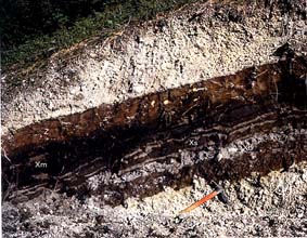
Figure 70. Tephra layer T at the surface on the northeast flank of Mount St. Helens before 1980, overlying
ash bed z and sets X and W. A brown, oxidized soil zone has developed in ash bed z and the upper part of set X.
Ice axe shown for scale. Photograph taken in 1974. (127K)
|
The layer is unweathered, except for slight oxidation in its upper part. No
pyroclastic-flow, surge, or ash-cloud deposits are associated with this tephra.
|
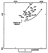
Figure 71. Thickness (in centimeters) of tephra layer T, Mount St. Helens. Cross (+) indicates approximate
position of probable source vent on north flank of volcano. (6K)
|
Layer T is well sorted and unstratified, and the pumice is highly vesicular.
Its clasts are larger relative to the layer thickness than clasts in most other voluminous pumice layers. Ferromagnesian
minerals in this layer are hypersthene, hornblende, and small amounts of augite. Hypersthene is usually slightly
more abundant than hornblende. A few samples from both the lower and upper parts of the layer suggest that augite
is less abundant in the lower part. According to Smith and others (1977, p. 210-211), extremely thin glass-vesicle
walls and subspherical voids characterize the pumice. Whole-rock analysis of three samples of the pumice indicates
a SiO2 content of 63-64 percent; samples from the bottom and top of the layer differed in SiO2
content by less than 0.1 percent.
Diagnostic features
Along its lobe, layer T can generally be identified as the uppermost coarse,
thick, light-gray pumice layer at or near the surface that is older than the deposits of 1980. It is much coarser
and lighter in color than any part of the underlying set X. It is similar to the older layer Wn that also extends
to the northeast but is distinguished from it by stratigraphic position, larger grain size relative to layer thickness,
and presence of augite. At more than about 20 km downwind, the large clast size relative to thickness of layer
T is conspicuous.
Close to and northeast of the volcano, layer T is coarser and thicker than
the A.D. 1980 tephras that overlie it. The axis of the layer T lobe is north of that for the 1980 deposits, and
layer T is virtually absent east of the volcano where the 1980 tephras are thickest (Sarna-Wojcicki and others,
1981; Waitt and Dzurisin, 1981). The augite content of layer T pumice, though small, is higher than that in the
A.D. 1980 pumice.
Stratigraphic relations
Near the volcano, layer T overlies a weak soil developed in ash bed z and
the underlying set X. It is overlain only by forest duff and products of the A.D. 1980 eruptions.
Distribution and thickness
Layer T is limited to the northeast side of the volcano and downwind toward
the northeast (fig. 72). Before 1980, the apparent primary thickness of the layer exposed
on the northeast flank of the volcano was as much as 215 cm. Bombs as much as 50 cm across, many with reddish-gray
cores, were common. Locally, thicknesses of as much as 400 cm could be measured on the northeast flank, but they
may have represented downslope mass movement of the pumice during or after accumulation.
Downwind, layer T decreases rapidly in thickness and grain size. At 10 km from
the volcano, it consists of about 40 cm of mostly lapilli (fig. 71). At 50 km it consists
of 5 cm of small lapilli in ash, and at 100 km of only 1-2 cm of ash. The layer has been recognized in northeast
Washington and northern Idaho at distances of nearly 500 km (Smith and others, 1968; Okazaki and others, 1972).
Origin and source
The rapid decrease of thickness and grain size downwind suggests that layer
T originated either from an eruption column that was relatively low or during winds of low or moderate velocity.
Carey and others (1989) proposed a peak height of only about 16 km for the eruption column.
C.A. Hopson (oral commun., l970) inferred from its distribution on the north
flank of the volcano that layer T was erupted from a vent on the north flank rather than from the summit. Before
1980, a marked decrease in layer T thickness could be observed on the north flank from timberline upslope toward
the summit.
Age
Lawrence (1938, 1939, 1954) determined from growth rings in trees near Spirit
Lake that layer T was erupted within a few years of A.D. 1800. Yamaguchi (1982) confirmed an A.D. 1800 date and
suggested that the eruption occurred between the growth periods of A.D. 1799 and 1800.
Previous designations and correlative units
Layer T is the unit designated as the "1802 lapilli deposit" by
Lawrence (1939, p. 51). Okazaki and others (1972) have correlated the unit with the Blackfoot ash in northeast
Washington and northwest Idaho.
Nineteenth century lithic ash
A thin ash bed was found in the pre-1980 forest duff at several places around
Mount St. Helens. On and near the southeast flank of the volcano (fig. 72), a lithic
ash probably erupted in A.D. 1842 could be recognized in multiple outcrops over an area of a few square kilometers.
It comprises a single, thin, gray bed of fine to coarse ash. The bed consists of nonvesicular to slightly vesicular
glass, dense rock particles, and fragments of mineral crystals, predominantly of hypersthene, hornblende, and augite.
No pumice was found in the deposits. The bed is as thick as 3 cm and is enclosed in organic forest litter; it was
recognized only where it forms a distinct bed within that litter. No diagnostic characteristics other than its
stratigraphic position are known.
|
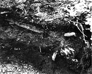
Figure 72. 1842(?) ash (at left of pocketknife), typically obscure and enclosed in forest duff,
about 7 km southeast of the center of Mount St. Helens. The thin edge of a gray pyroclastic-flow deposit, dark
set X, and layer We are visible below the 1842 (?) ash. (149K)
|
The 1842(?) ash probably was produced by one or more small phreatic eruptions
that ejected only particles of preexisting rock. Many such eruptions were reported from A.D. 1831 through A.D.
1857 (Holmes, 1955; Hoblitt and others, 1980). Although the deposit might include ash from any reported or unreported
eruption, it probably resulted chiefly from the event of November 22 or 23, 1842. That eruption is the only one
for which a distinct bed has been described that reached beyond the volcano, and the bed extended southeastward.
That eruption reportedly laid down a little more than a centimeter ("a half inch") of ash at The Dalles,
Oregon, about 100 km southeast of Mount St. Helens (Fremont, 1845).
A single, thin bed of ash younger than layer T was observed in several outcrops
on the north side of the volcano during this as well as other investigations (Okazaki and others, 1972, p. 85).
A sample from one of those outcrops is similar in grain size and composition to the 1842(?) ash; however, because
the 1842(?) ash presumbly was carried southeastward, the ash bed on the north side probably resulted from one or
more other 19th century eruptions.
Before 1980, thin deposits of ash-size material were visible elsewhere in forest
duff around the volcano. Some of these deposits probably originated from other eruptions in the 19th century that
were reported to have deposited visible amounts of ash on the flanks of the volcano (Gairdner, 1836; Fremont, 1845;
Holmes, 1955); however, others probably resulted from wind reworking and redepositing ash-size material.