
| Lake Pontchartrain Basin: Bottom Sediments and Related Environmental Resources |
Summary of Geological and
Chemical Data (cont.)Mississippi River Influence -- Bonnet Carré Spillway |
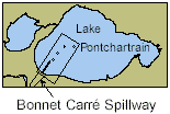 |
The Bonnet Carré Spillway was created by converting the site of former crevasses into a passageway designed to divert floodwaters from the Mississippi River away from New Orleans and into Lake Pontchartrain. It was constructed by the U.S. Army Corps of Engineers in 1931. During a controlled opening for 2 1/2 months in 1973, the inflowing waters deposited a large lobe of silty sand an average of 19 cm thick near the spillway mouth (Crocker, 1988).
The total amount of sediment entering Lake Pontchartrain during the 1997 opening (see below) can be estimated from averaged water inflow data and suspended solids estimates provided by the U.S. Army Corps of Engineers (James Austin, U.S. Army Corps of Engineers, New Orleans District, oral commun., 1999). For the 31 days of opening, assuming sediment water content at 60%, the total wet sediment volume would amount to 9.1 million tons. Spread over the entire lake area of 640 mi2, mean thickness would be 0.42 cm.
Oyster fishermen have noticed that when the spillway brought freshwater into Lake Pontchartrain, the reduction in salt resulted in increased oyster production in estuarine areas outside the Rigolets inlet (see fig. 5 for Rigolets location). Fresher waters reduced the effect of the parasitic oyster drill. This beneficial result for oyster harvests increased pressure for controlled openings of the Spillway even in the absence of flood risk. But such freshwater input created environmental changes that drew criticisms from local fishermen and environmental organizations (see topical abstracts in the Basics of the Basin Symposia, Lopez, this publication).
The Bonnet Carré Spillway was opened from March 17 to April 18, 1997, to relieve flood pressure on the Mississippi River. The discharge of turbid water was recorded by AVHRR remote sensing by multispectral satellite monitors (figs. 29 and 30). (Also see Bonnet Carré Spillway Event in Stumpf, this publication).
| Estimates of suspended sediment concentration (seston) in Lake Pontchartrain interpreted from Stumpf's remote sensing data (1998) | |
Figure 29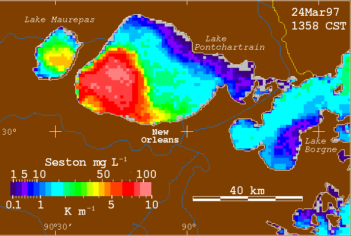 March 24, 1997 |
Figure 30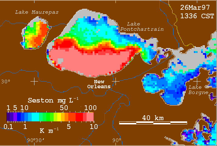 March 26, 1997 |
| (click on thumbnail images for larger views) | |
Subsequently, during May and June a massive algal bloom occurred, triggered by the combination of influx of dissolved nutrients and water freshening. For example, in earlier experimental release of water from the Bonnet Carré Spillway, nitrate concentrations increased by twentyfold in the mixed plumes (Demcheck and others, 1996). The resulting organic matter from plankton blooms decayed and created anoxic bottom conditions deleterious to benthic organisms and shrimp. This sequence of events triggered renewed debate about the direct and indirect costs and effects of spillway policy.
The sediment plots (figs. 31- 33) are based on data preceding the 1997 opening. The distribution of sediments reflects contributions of Mississippi River sediments from many previous openings. Figure 31 shows profiles of zinc and copper concentrations and sample distribution in the vicinity of the Bonnet Carré Spillway. The lower metal concentrations at locations very close to shore are attributable to dilution of finer grained (metal-enriched mineral fractions) with metal-poor sand.
Figure 31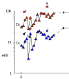 Profiles of Zinc and Copper Concentrations near the Bonnet Carré Spillway |
Figure 32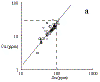 Plots of Copper and Lead against Zinc near the Bonnet Carré Spillway |
(click on thumbnail images for larger views) |
|
Plots of Cu and Pb against Zn (fig. 32) demonstrate that
internal (discriminant) ratios of key metals from independent sources are in good
agreement in the vicinity of the spillway. The relationships are also consistent with data
from nationwide sediment samplings in coastal waterways (NS&T, 1996). The data here
indicate that metal concentrations in lake sediments influenced by Mississippi River
sediments via the Bonnet Carré Spillway are within the general range of concentrations
for natural soils and estuarine sediments (see table 8). Their concentrations are not statistically distinguishable from sediments in more distant
parts of the lake. A mean of normal shales (compacted clay, silt, or mud) is shown for
comparison as dashed lines in figure 32.
Contaminants in Mississippi River sediments and waters have recently been the subject of a major research study (Meade, 1995). This study shows that pollutant influxes into and concentrations in the Mississippi River have generally decreased since the 1970’s. Very recent data (Presley and others, 1998) show that the concentration of many contaminants in Mississippi River sediments rose sharply after World War II, peaked in the 1970's, and has decreased sharply since that time. An example for lead is shown in figure 33. Core data have been shown to have close correlation with particulate matter composition in the river itself (Trefry, Metz and others, 1985; Metz, 1986; Trefry and others, 1986).
This relationship between time and pollutants in river-borne suspended matter also applies to contaminant concentrations in particulate matter brought in by the Mississippi River through the Bonnet Carré Spillway. National efforts to reduce pollutant discharge to the air and water have reduced the metal concentration of Mississippi River sediment in the last 25 years. More recent influxes of sediment from the Mississippi River probably have substantially lower metal and organic contaminant burdens than they did 25 years ago. Drawing in part on studies of Mississippi Delta sediments, the Discussion offers a more in-depth review of the role of Mississippi River influxes during the 1997 opening of the spillway. It also provides estimates of the metal proportions likely to be of pollutant origin in Lake Pontchartrain surficial sediments.
Figure 33. Lead concentrations
(ug/g) in a dated core from the Mississippi Delta (drawn from data in Presley and others, 1998).

| Forward to Coastal Waterway Impacts |
||
|
||