|
|
|
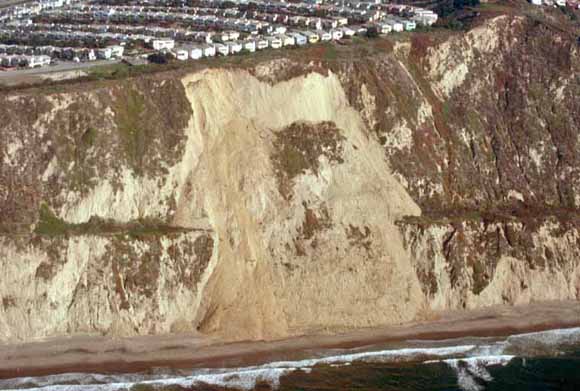
Central California, in the vicinity of San Francisco and Monterey Bays, has a history of fatal and damaging landslides, triggered by heavy rainfall, coastal and stream erosion, construction activity, and earthquakes. The great 1906 San Francisco earthquake (MS=8.2-8.3) generated more than 10,000 landslides throughout an area of 32,000 km2; these landslides killed at least 11 people and caused substantial damage to buildings, roads, railroads, and other civil works. Smaller numbers of landslides, which caused more localized damage, have also been reported from at least 20 other earthquakes that have occurred in the San Francisco Bay-Monterey Bay region since 1838. Conditions that make this region particularly susceptible to landslides include steep and rugged topography, weak rock and soil materials, seasonally heavy rainfall, and active seismicity. Given these conditions and history, it was no surprise that the 1989 Loma Prieta earthquake generated thousands of landslides throughout the region. Landslides caused one fatality and damaged at least 200 residences, numerous roads, and many other structures. Direct damage from landslides probably exceeded $30 million; additional, indirect economic losses were caused by long-term landslide blockage of two major highways and by delays in rebuilding brought about by concern over the potential long-term instability of some earthquake-damaged slopes. |
|
This publication consists of the following articles:
|
Download the text of this publication as a 183-page PDF file (pp1551c.pdf; 10.1 MB)
Download Plate 1 as a ~37"x27" PDF file (pp1551c_plate1.pdf; 16.8 MB)
Download Plate 2 as a ~38"x27" PDF file (pp1551c_plate2.pdf; 18.8 MB)
Download Plate 3 as a ~24"x20" PDF file (pp1551c_plate3.pdf; 8.7 MB)
Download Plate 4A as a ~37"x30" PDF file (pp1551c_plate4a.pdf; 35.2 MB)
Download Plate 4B as a ~32"x30" PDF file (pp1551c_plate4b.pdf; 31.8 MB)
Download Plate 4C as a ~32"x30" PDF file (pp1551c_plate4c.pdf; 28.7 MB)
Download Plate 4D as a ~32"x30" PDF file (pp1551c_plate4d.pdf; 34.9 MB)
Download Plate 5 as a ~18"x22" PDF file (pp1551c_plate5.pdf; 7.1 MB)
For questions about the content of this report, contact David Keefer
|
This publication is part of the set of four multi-chapter USGS Professional Papers on the Loma Prieta, California, Earthquake of October 17, 1989: Professional Paper 1550, Earthquake Occurrence , Coordinators: William H. Bakun and William H. Prescott Professional Paper 1551, Strong Ground Motion and Ground Failure, Coordinator: Thomas L. Holzer Professional Paper 1552, Performance of the Built Environment, Coordinator, Thomas L. Holzer Professional Paper 1553, Societal Response, Coordinator: Dennis S. Mileti |
Download a copy of the latest version of Adobe Reader for free.
|
Help |
PDF help |
Publications main page |
This report is also available from:
USGS Information Services, Box 25286,
Federal Center, Denver, CO 80225
telephone: 888 ASK-USGS; e-mail: infoservices@usgs.gov
| Department of the Interior
| U.S. Geological Survey |
URL of this page: https://pubs.usgs.gov/pp/pp1551/pp1551c/
Maintained by: Michael Diggles
Created: July 13, 2006
Last modified: July 20, 2006 (mfd)