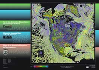
Magnetic anomaly map of North America
Links
- More Information:
- Documents:
- Plate: Map (pdf)
- Download citation as: RIS | Dublin Core
Abstract
This digital Magnetic Anomaly database and map for the North American continent is the result of a joint effort by the Geological Survey of Canada (GSC), U.S. Geological Survey (USGS), and Consejo de Recursos Minerales of Mexico (CRM). The database and map represent a substantial upgrade from the previous compilation of Magnetic Anomaly data for North America, now over a decade old (Committee for the Magnetic Anomaly Map of North America, 1987). This integrated, readily accessible, modern digital database of magnetic anomaly data will be a powerful tool for further evaluation of the structure, geologic processes, and tectonic evolution of the continent and may also be used to help resolve societal and scientific issues that span national boundaries. The North American magnetic anomaly map derived from the digital database provides a comprehensive magnetic view of continental-scale trends not available in individual data sets, helps link widely separated areas of outcrop, and unifies disparate geologic studies. This booklet outlines the data processing and compilation procedures used to produce the magnetic anomaly database and map that accompany this booklet.
Suggested Citation
North American Magnetic Anomaly Group, Bankey, V., Cuevas, A., Daniels, D.L., Finn, C.A., Hernandez, I., Hill, P.L., Kucks, R., Miles, W., Pilkington, M., Roberts, C., Roest, W., Rystrom, V., Shearer, S., Snyder, S.L., Sweeney, R.E., Velez, J., 2002, Magnetic anomaly map of North America: Special Map, Report: 31 p.; 1 Plate: 56.02 x 40.01 inches, https://doi.org/10.3133/70211067.
Study Area
| Publication type | Report |
|---|---|
| Publication Subtype | USGS Unnumbered Series |
| Title | Magnetic anomaly map of North America |
| Series title | Special Map |
| DOI | 10.3133/70211067 |
| Year Published | 2002 |
| Language | English |
| Publisher | U.S. Geological Survey |
| Description | Report: 31 p.; 1 Plate: 56.02 x 40.01 inches |
| Other Geospatial | North America |
| Projection | Spherical Transverse Mercator Projection |
| Scale | 10000000 |


