
Woods Hole Coastal and Marine Science Center—2022 Annual Report
Links
- Document: Report (8.26 MB pdf) , HTML , XML
- Download citation as: RIS | Dublin Core
Coastal and Marine Science Based in Woods Hole, Massachusetts
The U.S. Geological Survey (USGS) Woods Hole Coastal and Marine Science Center (WHCMSC) in Woods Hole, Massachusetts, is one of three centers serving the mission of the USGS Coastal and Marine Hazards and Resources Program. Since its authorization by Congress in 1962, the Coastal and Marine Hazards and Resources Program has served as the primary Federal program for marine geology and physical science research and is responsible for the Nation’s entire coastal and marine landscape. The center’s staff of about 100 conducts scientific research throughout the United States and internationally to describe and understand the processes shaping coastal and marine systems, from the deep sea to the continental shelf, to beaches, salt marshes, and the Great Lakes. The center’s research products are used by Federal agencies, State and local entities, private organizations, and the public to manage risks posed by natural hazards, promote safter, more productive coastal communities, and improve stewardship of natural resources.
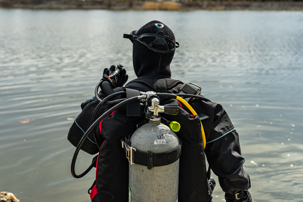
Sandy Brosnahan of the U.S. Geological Survey Woods Hole Coastal and Marine Science Center preparing to dive in the Norwalk River in Connecticut to service and level a bottom-mounted acoustic Doppler current profiler, a device that uses sound waves to measure the speed and direction of currents throughout the water column. Understanding how the sea moves provides important information about biological, chemical, and physical properties of the ocean. Photograph by the U.S. Geological Survey.
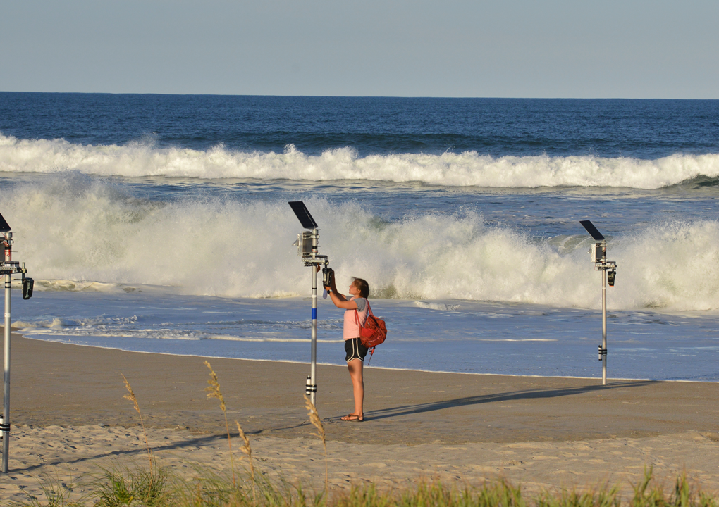
As part of the During Nearshore Event Experiment (DUNEX), U.S. Geological Survey scientists deployed a cross-shore array of poles equipped with various sensors to measure water level and other physical conditions and processes at Pea Island National Wildlife Refuge on the outer banks of North Carolina. Photograph by the U.S. Geological Survey.
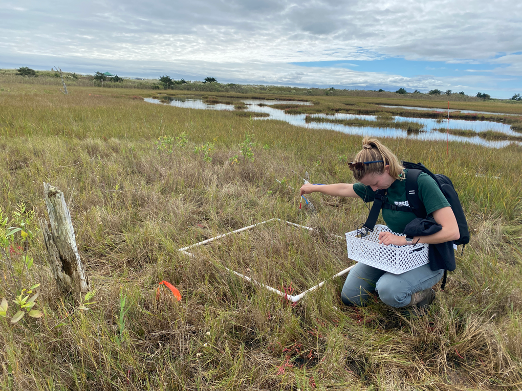
Operations specialist and geographer Jen Cramer testing the newly acquired OceanInsight HDX Miniature Spectrometer, a modified laboratory spectroradiometer, at the South Cape Beach marsh in Waquoit Bay National Estuarine Research Reserve, Massachusetts. Photograph by the U.S. Geological Survey.
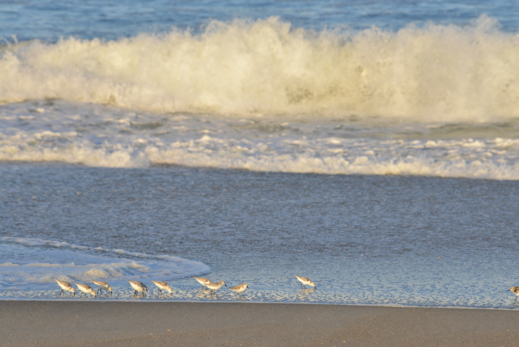
Shorebirds on the Outer Banks of North Carolina. Photograph by the U.S. Geological Survey.
Coastal and Shelf Geology
Shifting shorelines are the most visible result of a constantly changing coastal system that extends from shallow estuaries, across wetlands and beaches, and into adjacent ocean waters.
The Coastal and Shelf Geology group conducts mapping, modeling, and data analysis to better understand and describe the underlying geology and processes that shape these environments. The group applies modern technologies, such as high-resolution sea-floor mapping systems and uncrewed aircraft systems (UASs, or drones), to characterize the coast above and below the water. The detailed maps of the coastal landscape created from this research are used to improve forecasts of coastal change and identify hazards in areas vulnerable to storms, chronic erosion, and sea-level rise.
Coastal Change Hazards and Sea-Floor Mapping Project: Massachusetts Integrated Coastal Studies
Highlights of 2022
The USGS, in partnership with the Commonwealth of Massachusetts, initiated the Massachusetts Integrated Coastal Studies project in 2018 to further investigate the processes that control sediment movement in Cape Cod Bay. Through this multitiered research initiative, USGS scientists are developing and applying a coupled ocean-wave-sediment transport model for the bay at different scales by using our Coupled Ocean-Atmosphere-Wave-Sediment Transport (COAWST) modeling system. This project includes comprehensive sea-floor mapping of the bay, numerical modeling of coastal processes and their effects on coastline stability, and improved shoreline change assessments with new capabilities for predicting shoreline change. This work can help coastal zone managers better understand how, where, and why sediment is transported in western Cape Cod Bay.
Nantucket Sound Mapping
The project team conducted a geophysical survey in western Nantucket Sound offshore Massachusetts. About 680 kilometers of high-resolution bathymetric and sub-bottom data were collected. These data can be used to help locate potential sand sources, delineate habitat, improve navigation charts, aid in maritime safety, and determine potential renewable energy infrastructure placement. Dale Oakley Jr., Assistant Director of the Mashpee Wampanoag Tribe’s Department of Natural Resources, assisted one day in the field. This mapping effort was later reviewed as part of the Mashpee Wampanoag Tribe’s Preserving Our Homelands science camp.
Evaluated Two Methods of Predicting Future Shoreline Position
Data from different parts of the Massachusetts coast, including Cape Cod Bay, were used to study two methods of predicting future shoreline position. The forecasts created by these methods were tested against observed shoreline positions to determine their accuracy.
Simulated Sediment Transport and Coastal Erosion
Using the COAWST modeling system, the project team simulated sediment transport and coastal erosion in the Gulf of Maine and Cape Cod Bay from January through April 2021—a time that included several strong nor’easters. This investigation can help coastal zone managers better understand how, where, and why sediment is transported in the coastal zone.
Published Cape Cod Bay Mapping Data
In August 2019, the project successfully completed the first-ever comprehensive, high-resolution geophysical survey of Cape Cod Bay and the first systematic bathymetric mapping of the entire bay since the 1930s. In 2022, those data were published. The data can be used to locate sandy shoreface deposits, potential new fishing grounds, buried lakes, and evidence for glaciotectonics.
Sea-Level Rise Hazards and Decision Support
Highlights of 2022
Sea-level rise will have a variety of future effects on the coast, including land loss from inundation and erosion; migration of coastal landforms and environments; increased water levels, inland extent, and duration of storm-surge flooding; wetland losses; changes in coastal groundwater movement in relation to land; and effects on human development, infrastructure, and social systems. This project brings together multidisciplinary scientists from the USGS and other organizations to measure, model, and predict the effects of sea-level rise on the Nation’s coasts. The project synthesizes information on coastal environments and uncertainties, as well as current knowledge of coastal processes, into an analytical framework for evaluating the likelihood of various sea-level-rise effects. Researchers with this project work with State, academic, and nonprofit collaborators and stakeholders to ensure that the research outcomes are useful to managers who face decisions regarding future hazards.
Coastal Change Likelihood Assessment: Northeast Pilot Study Products
The project continues to update the nearly 20-year-old coastal vulnerability to sea-level rise index, which assesses the susceptibility of the Nation’s coast to sea-level rise. The updated product is the Coastal Change Likelihood assessment, a framework that synthesizes existing datasets to evaluate the likelihood of coastal change along the U.S. coastlines within the coming decade. In 2022, products for the Northeast pilot study, including a data report, data release, and geonarrative, were reviewed. They were released in early 2023. Funded work through the Great Lakes Restoration Initiative also began, expanding the project to the Great Lakes region in an interagency effort, with the U.S. Army Corps of Engineers and the National Oceanic and Atmospheric Administration.
Forecasting Future Suitable Habitat for Piping Plover
In 2017, this project began linking physical response models to Charadrius melodus (piping plover) habitat models, producing forecasts of barrier island characteristics and plover habitat availability. Companion papers document a linked Bayesian belief network methodology to forecast future suitable habitat for piping plover at Fire Island National Seashore in New York under several possible sea-level-rise scenarios. An overview presentation was given to Fire Island National Seashore staff to present the findings from this research.
“Coastal Effects” Chapter of Fifth National Climate Assessment Underway
A project scientist began writing the national “Coastal Effects” chapter of the Fifth National Climate Assessment. The assessment aims to inform natural resource and utility managers, public health officials, emergency planners, financial risk managers, and other stakeholders as they consider climate-related risks in their decision making.
Aerial Imaging and Mapping
Highlights of 2022
Uncrewed aircraft system (UAS) technology provides a rapid and low-cost solution for mapping coastal environments and assessing short- and long-term changes. The interdisciplinary nature of the data collected and the breadth of its applications make UAS technology applicable to multiple scientific investigations. The center’s Aerial Imaging and Mapping Group (AIMG) is developing the capability to provide operational remote-sensing support to coastal, estuarine, and lacustrine research using UAS technology. Group responsibilities include data acquisition, processing, and publication of UAS-collected data products and working collaboratively with the U.S. Department of Interior/USGS UAS operators to explore new UAS technology, sensor development, and new techniques of data acquisition. This capability supports the Remote Sensing Coastal Change project, the Coastal Change Hazards programmatic focus, the national UAS project office, and other Bureau-wide remote-sensing projects. High-resolution imagery and elevation maps created from the remote-sensing data are used in change-detection studies (for example, to detect coastal erosion), hurricane damage assessments, natural disaster responses, and the imagery and maps to support situational awareness for emergencies. Collecting data remotely by UAS technology is an efficient and often safer alternative to collecting data by hand.
Fieldwork
The AIMG collaborated with the USGS National Uncrewed Systems Office to test the newly acquired OceanInsight HDX Miniature Spectrometer, a modified laboratory spectroradiometer, against the industry standard product, at the South Cape Beach marsh in Waquoit Bay, Massachusetts. The UAS imagery collected in this field effort is being used in a secondary methods study for machine learning classification of invasive Phragmites australis (common reed), which AIMG members are investigating for potential use in mapping the invasive reed on Assateague Island National Seashore, a barrier island on the east coast of Maryland and Virginia. The group also assisted the USGS New York Water Science Center with thermal mapping of a local cranberry bog and wetland ecosystem at the Quashnet River in Mashpee, Massachusetts.
UAS Introductory Instruction
An AIMG member became a lead U.S. Department of the Interior A–450 instructor, giving the group the capability of hosting and teaching the introductory small UAS piloting class for USGS. Members of the AIMG served as instructors for the April 2022 introductory class in Fort Collins, Colorado.
Interagency Knowledge Transfer and ENVI Training
The AIMG sent three members to Cape Hatteras National Seashore in North Carolina to train new U.S. National Park Service UAS pilots in structure-from-motion best practices. The group was able to map the Bodie Island Light Station and a section of the beach at Ocracoke Inlet. The group also organized a virtual training in spectral imagery analysis using ENVI image-analysis software. The training was attended by several Woods Hole scientists and was aimed at exposing them to another tool for coastal remote-sensing analysis.
Sea-Floor Mapping
Highlights of 2022
The Sea Floor Mapping Group (SFMG) maintains a centerwide capability that supports many of the center’s projects and works closely with the other two Coastal and Marine Hazards and Resources Program science centers in St. Petersburg, Florida, and Santa Cruz, California. The SFMG is a team of geologists, engineers, electronics technicians, physical scientists, and geographers with expertise in the acquisition, processing, and analysis of marine, coastal, and lacustrine geophysical and geologic data. Working across diverse environments, the technical team uses acoustic techniques to collect detailed information about the sea floor, such as its shape, sediment composition and distribution, and underlying geologic structure and sediment. Sea-floor video, photographs, sediment cores, and samples are also collected to validate the acoustics and provide a comprehensive foundation for studies of sediment and contaminant transport, landslide and tsunami hazards, gas hydrates and methane and carbon flux, benthic habitat quality, sediment availability, shoreline change, and coastal evolution. Managers, policymakers, and other stakeholders use the map products derived from these studies to inform coastal and ocean resource-management decisions.
Project Support
The SFMG conducted multiple geophysical and seismic surveys, core-sampling operations, and other field efforts in support of numerous projects to (1) define the geologic framework of the sea floor within the Massachusetts coastal zone; (2) investigate the sediments and shallow stratigraphy of the New England Mud Patch and surrounding region; (3) investigate stratigraphy and mudflow hazards along the Mississippi River Delta front; (4) identify active methane seepage along the mid-Atlantic shelf; (5) investigate methane gas presence in the sediment, water, and atmosphere of Chesapeake Bay; and (6) map the seasonal distribution of Ammodytes dubius (northern sand lance) within the Stellwagen Bank National Marine Sanctuary offshore Massachusetts. The SFMG also began supporting postcruise data processing, interpretation, and publication for three USGS efforts, including one in response to the 2010 Deepwater Horizon oil spill in the Gulf of Mexico.
Outreach
The center hosted 25 students and culture keepers from the Mashpee Wampanoag Tribe’s Preserving Our Homelands summer camp for an annual field trip focused on introducing the group to Cape Cod geology and hydrology. The students listened to an informational talk and participated in a guided exploration of distinctive glacial landforms in the Beebe Woods conservation area in Falmouth, Massachusetts.
Research and System Development
-
1. The SFMG continued to work with a boat design service company to design a new research vessel.
-
2. Fabrication and testing of the new Seabed Observation and Sampling System (SEABOSS) 2.0 was completed, and a system schematic, user manual, and set of SEABOSS 2.0 documentation was created. The system is scheduled for project use in 2023.
-
3. The SFMG continued to work on the design of a multicorer system for operation in shallow shelf to deepwater settings to collect multiple high-quality, minimally disturbed sediment cores in one deployment. The multicorer was successfully operated during fieldwork in the Mississippi River Delta front.
-
4. The center acquired a next generation, high-resolution chirp sub-bottom profiling system for use in shallow-water environments. It was successfully used during multiple field efforts in 2022.
Geologic Mapping: Links to Coastal Vulnerability and Hazards
Highlights of 2022
The objective of the geologic mapping project is to characterize a region’s resources and potential coastal hazards through understanding of the region’s geologic framework. This work provides baseline datasets and derivative interpretive maps that offer a geospatial basis for scientific research and provides critical information to planners and decision makers who oversee the management of resources and mitigation of hazards in the coastal ocean. Geologic mapping project scientists also conduct scientific analysis and develop cutting-edge methodologies to examine these data and later communicate their results to the scientific community and the public.
Currently the project consists of two tasks: (1) The Delmarva regional study and (2) Lake Superior stamp sands work.
Delmarva Regional Study
The Sea Floor Mapping Group continued to work collaboratively with the Bureau of Ocean Energy Management, State agencies, universities, and other regional stakeholders to deepen understanding of the coasts and continental shelves and to help partners incorporate many recent USGS data releases and publications into their own studies. The offshore wind and support industries are using these data and interpretations extensively for siting energy transmission and support infrastructure.
Lake Superior Stamp Sands
In a joint effort with the USGS Great Lakes Science Center, the WHCMSC mapped an area of Lake Superior that has been—and continues to be—greatly affected by a legacy of copper mining in the region. Geophysical, photographic, and sampling data were collected to support efforts to determine changes in substrate since a baseline survey in 2005 and the previous USGS survey in 2018. New methods are being developed to assess the concentration of stamp sands (waste materials from the mines) in bottom sediments, which can help Federal, State, local, and Tribal partners decide on the best mitigation measures.
National Sea-Floor Mapping and Habitat Studies
Highlights of 2022
The National Sea-Floor Mapping and Habitat Studies—Atlantic project has two objectives: to produce high-resolution geologic substrate maps of the seabed and to collaborate with the National Oceanic and Atmospheric Administration (NOAA) and academic scientists to better understand the role geologic substrates play in determining the distribution and ecology of fishery species.
This project produces a series of online interpretive maps that show the distribution of geologic seabed substrates and processes in the NOAA Stellwagen Bank National Marine Sanctuary 20 miles offshore from Boston, Massachusetts, at a scale of 1:25,000. The maps serve as the template for a new approach to seabed mapping.
Substrate maps provide a framework for scientific research in the region and for managing fishery resources and infrastructure. Stellwagen Bank is the principal habitat in the eastern Gulf of Maine for Ammodytes dubius (northern sand lance), a schooling fish that is the primary food resource for marine mammals, seabirds, and most of the bank’s commercial fishery species—including Gadus morhua (Atlantic cod), Melanogrammus aeglefinus (haddock), and Thunnus thynnus (Atlantic bluefin tuna). Geologic substrate mapping can determine the extent of suitable habitat for the species and provide a basis for assessing the size of the northern sand lance population and identifying its dependence on seasonal changes of water-column properties.
Sampling Survey in Stellwagen Bank National Marine Sanctuary
WHCMSC scientists and technical staff conducted a Seabed Observation and Sampling System (SEABOSS) survey in collaboration with NOAA’s Stellwagen Bank National Marine Sanctuary to acquire sea-floor samples, video, and photographs within the Stellwagen Bank National Marine Sanctuary. This is part of a long-term sampling effort to map the seasonal distribution of northern sand lance within the sanctuary.
Coastal Change Hazards Technical Capabilities and Applications
Highlights of 2022
The Coastal Change Hazards programmatic focus was established to address societally relevant issues along the coast through research and products that assist the Nation with coastal change hazard challenges. Multiple research projects rely on core technical capabilities to further scientific progress. Assembling a cross-center collaborative technical team to cut through data silos and facilitate knowledge exchange contributes to more efficient development of innovative science on coastal change hazards that is in demand and applicable at the national scale.
The Coastal Change Hazards Technical Capabilities and Applications (TCA) project leverages technical talent across the Coastal and Marine Hazards and Resources Program to bridge capability, expertise, and collaboration between the centers. The project maintains high-visibility, public-facing platforms for delivery of coastal change hazard products and sustains the relevancy and currency of the underlying assessments. The TCA group advises other USGS Coastal Change Hazards projects on how to expand existing assessments and incorporate new assessments into the coastal change hazards portfolio. This advisement helps ensure additions contribute to a cohesive national story.
Added New Data to Coastal Change Hazards Portal
The TCA project supports the maintenance of the USGS Coastal Change Hazards Portal, a web visualization tool that allow users to view and download important coastal data, such as past rates of shoreline change, effects on landscape caused by sea-level rise, and coastal flooding due to extreme storms. In 2022, in addition to keeping up with required changes and updates, new data were added to the portal. The new data include a national dataset describing marsh health called the unvegetated-vegetated marsh ratio (UVVR) and data describing the protective nature of coral reefs against storm impacts. Several existing datasets were expanded to include data for Puerto Rico, including shoreline change data and coastal flooding impacts due to hurricanes.
Published DSAS Version 5.1 and Updated User Guide
The Digital Shoreline Analysis System (DSAS) is software that enables a user to calculate rate-of-change statistics from a time series of shoreline positions. The project team published the latest version of DSAS, as well as an updated user guide. As of October 2022, DSAS version 5 was cited in over 230 scientific papers, and the tutorial videos have 7,000 combined views. Between April 2021 and March 2022, the DSAS project page website was accessed 277,235 times, and the software site was accessed 15,500 times with 12,499 downloads.
Updated Shoreline Position Databases and Change Rate Products
The USGS maintains data on historical shoreline positions for the United States coasts from both older and contemporary sources. These shoreline data are compiled and analyzed in the USGS DSAS software to calculate rates of change. In 2022, the TCA project updated shoreline position databases and shoreline change-rate products for Massachusetts, Georgia, Florida, Puerto Rico, and California. The project team also created the National Shoreline Change Catalog web page to help users find existing, published USGS shoreline change data.
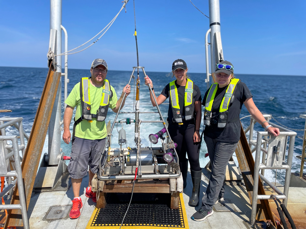
Seth Ackerman, Marie Bartlett, and Maeve Munnelly on the deck of the research vessel Auk with the mini–SeaBed Observation and Sampling System (mini-SEABOSS) during a survey with scientists from the National Oceanic and Atmospheric Administration Stellwagen Bank National Marine Sanctuary. Photograph by the U.S. Geological Survey.
Gas Hydrates and Geohazards
Gas hydrates and geohazards research at the center is focused on three themes: gas hydrates (naturally occurring icelike deposits made of water and gas), earthquake and tsunami hazards, and the sea floor beyond 200 nautical miles from shore, known as the extended continental shelf (ECS).
USGS scientists work together to study the formation and distribution of gas hydrates in nature, the potential of hydrates as an energy resource, and the possible environmental effects of gas hydrates when they break down and release methane (a potent greenhouse gas) into sediments, the ocean, or the atmosphere. The USGS works closely with other Federal agencies on implementing national gas hydrate research priorities and has been a leader in gas hydrates research for more than three decades.
Underwater earthquakes can generate tsunamis that cause hazards for coastal communities. Scientists at the center study the recent history of underwater earthquakes and tsunamis and evaluate the future potential and probable impacts of such events on a regional basis. Their research results are used in evaluations of earthquake risk zoning, public disaster education and preparedness, and engineering and building codes.
The Gas Hydrates and Geohazards group also works with other Federal agencies to explore and define the limits of the U.S. extended continental shelf. Further understanding of the resource potential of these vast areas in the Arctic, Atlantic, and Pacific Oceans will improve natural resource management and promote economic prosperity.
Gas Hydrates Project
Highlights of 2022
Naturally occurring gas hydrate is an icelike combination of water and (usually) methane gas that forms in sediments below the sea floor and in areas of continuous permafrost when pressure and temperature conditions are appropriate. Gas hydrate traps a large quantity of the methane in the global system. The USGS Gas Hydrates Project includes scientists at the USGS WHCMSC; the USGS Central Energy Resources Science Center in Denver, Colorado; the USGS Earthquake Science Center at Moffett Field, California; and the Pacific Coastal and Marine Science Center in Santa Cruz, California. In evaluating the resource potential of gas hydrate and the environmental effects of methane released from the sea floor, USGS Gas Hydrates Project scientists address questions related to the production and fate of methane. Many of the project’s efforts are conducted with support from the U.S. Department of Energy.
Chapters on Global Gas Hydrates on Marine Margins
USGS Gas Hydrates Project scientists contributed as lead authors or coauthors to 6 of the 36 chapters in a new monograph (published January 2022) that compiles information about natural gas hydrate deposits on global marine margins. Project scientists in Woods Hole were lead authors of chapters on the first modern updates of gas hydrate distribution on all Alaskan marine margins and on the U.S. Atlantic margin. They contributed to chapters on hydrates offshore the Canadian Pacific Northwest and the eastern coast of India.
Invented New Gas Analysis Instrumentation
With sponsorship from the U.S. Department of Energy, the Gas Hydrates Project built and proved an automated system for the sequential analysis of 16 samples containing aqueous phase dissolved gas. The new system, called the Auto-SIM, is used to measure the concentration of carbon dioxide, methane, and higher order hydrocarbons in samples and to make stable carbon isotopic measurements for methane and carbon dioxide in nearly real time in the field.
U.S. Atlantic Margin: Updated Map of Shallow Gas and Gas Hydrate Distribution
Using a supervised machine learning approach, the Gas Hydrates Project automated analysis of processed multichannel seismic data for delineation of features associated with shallow sub-sea-floor gas and gas hydrate on the northern U.S. Atlantic margin between Cape Hatteras and Hudson Canyon. The analysis used multichannel seismic data collected in 2018 during the Mid-Atlantic Resource Imaging Experiment cruise. Results reveal that gas hydrates and shallow gas are more widespread than previously thought.
Gulf of Mexico: Continued Analysis of Samples
Project scientists continued collaborating on the analysis of samples recovered from hydrate-bearing units during the 2017 northern Gulf of Mexico drilling program. The range of studies the project collaborated on represents a whole-system approach to studying natural gas hydrates and highlights the breadth of USGS Gas Hydrates Project contributions to fundamental studies and applied research on advanced simulation of gas hydrate reservoirs.
Law of the Sea—Outer Limits of the U.S. Continental Margins
Highlights of 2022
The USGS Law of the Sea project is part of a Federal interagency effort to identify the regions beyond 200 nautical miles from shore where the United States can manage resources found on and below the sea floor. These areas, called the extended continental shelf (ECS), are determined by scientific and legal criteria set forth in the United Nations Convention on the Law of the Sea. U.S. interests are served by knowing the outer limits of its ECS and where these limits may overlap with neighboring countries. The main goal of the interagency project is to develop a submission package that describes the outer limits of the U.S. ECS.
This effort is led by the U.S. Department of State. The USGS contributes knowledge of geology and sediment thickness, and the National Oceanic and Atmospheric Administration (NOAA) contributes knowledge about the morphology and bathymetry of the U.S. continental margins. The USGS participated in or led 10 major research expeditions between 2007 and 2016, during which more than 28,000 kilometers of multichannel seismic reflection data were acquired along the U.S. margins.
Fiscal year 2022 marks the end of the formal documentation efforts of the USGS Law of the Sea project, with the creation of the material necessary for a submission describing the U.S. ECS outer-limit points. The United States will release an executive summary of the U.S. outer-limit points with a simultaneous Federal Register notice.
Formal Documentation of the Seven Core Regions and Their ECS Outer-Limit Points
The project achieved its primary goal of finishing the formal documentation of the seven core regions (Arctic, Atlantic, Bering, Eastern Gulf of Mexico, Western Gulf of Mexico, Marianas, and Pacific) and their ECS outer-limit points. This included making final edits to the documentation from five of the seven core regions (Arctic, Bering, Eastern Gulf of Mexico, Western Gulf of Mexico, and Pacific) and creating the final drafts for the remaining two regions (Marianas and Atlantic). The final drafts for the Marianas and Atlantic had significant USGS contributions. Additionally, work was nearly completed on documenting possible alternatives to the ECS in the Pacific region and developing a fully vetted submission package for Hawaii (though it will not be part of the formal submission package).
Marine Geohazards Sources and Probability
Highlights of 2022
The Marine Geohazards Sources and Probability project has three primary objectives:
-
1. quantify the probability of marine hazards, such as earthquakes, landslides, tsunamis, and volcanoes, in marine and coastal environments by using geological and geophysical data, interpretations, and models;
-
2. understand the underlying processes of these marine hazards to inform hazard estimations; and
-
3. develop reliable deterministic and probabilistic estimates of possible hazards and the probability of occurrence to be used by engineers and policymakers.
Chirp Seismic Survey and Piston Coring on the New England Margin
In collaboration with the University of Texas Applied Research Laboratories, the U.S. Naval Research Laboratory, and the USGS Pacific Coastal and Marine Science Center, scientists at the center conducted a chirp seismic survey and piston-coring effort on the New England margin to support continuing investigation of the sediments and shallow stratigraphy of the New England Mud Patch and surrounding region. During this fieldwork, the center’s new multicorer—created in collaboration with the Sea Floor Mapping Group—was tested along the southern New England margin.
Seismic Surveys and Coring Along the Mississippi River Delta Front
The center conducted a multibeam echosounder, chirp, and multichannel seismic survey and slow-coring effort to support a continuing project investigating stratigraphy and mudflow hazards along the Mississippi River Delta front. Data were collected between Southwest and South Passes in water depths between 20 and over 300 meters. The center’s new multicorer was successfully operated during this fieldwork.
High-Resolution Mapping and Imaging of Past Nodule Activities on Blake Plateau
Center scientists conducted high-resolution mapping and photographic imaging of a region of the Blake Plateau in the Atlantic Ocean where polymineralic nodule extraction techniques were tested in 1970. The new maps and image mosaics can be used to assess the scale of the impacts to the sea floor and the level of recovery over the last 52 years. The USGS is partnering with the Bureau of Ocean Energy Management and the National Oceanic and Atmospheric Administration on this effort.
Coastal and Estuarine Dynamics
Coastal systems are dynamic—they change constantly because of the movement of sediment caused by waves, wind, currents, and tides as well as storms and sea-level rise. The ability to predict how the coast will respond to these forcing conditions can mitigate vulnerabilities to hazards, such as loss of infrastructure, declines in tourism and recreational use, and effects on marine habitats. Scientists at the center use cutting-edge oceanographic equipment to observe and measure the processes that transport sediment within the coastal ocean. These observations are used to develop computer models to better understand the past, present, and future states of coastal systems. The models developed at the center vary in scale—ranging from local estuaries or barrier islands to the entire U.S. Atlantic coast—and take advantage of modern high-performance computing. This combination of observations and modeling improves hazard and resource assessments that provide coastal managers with important information on the coastal system for making knowledge-based decisions.
Cross-Shore and Inlets Processes
Highlights of 2022
Understanding the exchange of water, sediment, and biological particles between the inner shelf and back-barrier estuaries is critical for determining extreme water levels, the formation and maintenance of inlets, barrier island evolution, and pollutant and larval transport. These connections are controlled by cross-shore processes, including wave-driven inner-shelf and nearshore processes, dune overtopping, breaching, transport through existing and new inlets, and estuarine circulation. The Cross-Shore and Inlets Processes project objectives are to further our understanding and increase our ability to predict the evolution of the form and shape of the coast, from estuaries to the continental shelf.
Project tasks include (1) leading the development of the Coupled Ocean-Atmosphere-Wave-Sediment Transport (COAWST) modeling system; (2) identifying regional locations where shoreline change is dominated by cross-shore sediment processes; (3) investigating the processes that create new inlets (breaching) and the dynamics that control inlet stability and closure; (4) investigating controls on the exchange of flows and material transport through inlets, specifically the interaction of waves with the vertical structure of the currents, on the sediment transport into the bay, ebb shoal effects, and sediment bypassing; and (5) communicating project findings through publications and outreach and by providing access to data and model results via the Coastal Change Hazards Portal.
Published COAWST 10-Year Forecast Data Release
The COAWST 10-year forecast data release, “Collection of COAWST Model Forecast for the US East Coast and Gulf of Mexico,” was published in 2022. The modeling system was developed to study impacts of storms on coastal systems and has been executed daily since 2010, with outputs written every hour. Users can access the model output data to analyze various physical properties and processes such as water level, temperature, salinity, currents, wave heights, periods, and directions for research. Also, the model output can be used to guide smaller scale simulations for studying regional coastal response to storms or other natural phenomena at specific time periods.
Completed Hurricane Florence Geonarrative
The USGS partnered with North Carolina State University, Louisiana State University, and the University Corporation for Atmospheric Research to investigate hurricane-induced compound flooding and sediment dispersal by using coupled hydrology and ocean models. The state-of-the-art model involves integrating a hydrologic model into the COAWST framework, which is a combination of atmospheric, waves, and ocean circulation models. This offers the potential to investigate the role of three-dimensional land-ocean-interaction processes in coastal storm hazards. The team created the “Hurricane Florence Numerical Modeling” geonarrative to highlight the motivation for this work, as well as atmospheric modeling, hydrological modeling, and contaminant tracking. This work is supported by the Additional Supplemental Appropriations for the Disaster Relief Act of 2019 (Public Law 116–120, 113 Stat. 871).
Total Water Level and Coastal Change
Highlights of 2022
The Next-Generation Total Water Level and Coastal Change Forecast project is a collaborative effort between all three USGS Coastal and Marine Science Centers (in Woods Hole, Massachusetts; St. Petersburg, Florida; and Santa Cruz, California) to validate, improve, and expand forecasts and uncertainty estimates from the USGS Total Water Level and Coastal Change (TWL&CC) Forecast Viewer. The TWL&CC Forecast Viewer is a web-based platform that includes a multiday forecast based on model simulations of tides, storm surge, offshore wave conditions, and local coastline characteristics. The model is deployed on approximately 4,700 kilometers of open, sandy coastline on the Atlantic and gulf coasts, with ongoing expansion to the Pacific coast and nonsandy environments. It is the only national-scale, real-time model for coastal change. Scientists from each of the three centers aim to (1) assess forecast skill by comparing the forecasts to observations, (2) improve forecasts by incorporating new data and theory into the model, (3) develop spatially varying and ensemble versions of the model that include uncertainty estimates, and (4) improve quantification of coastal hazards. Model improvements are incorporated into the TWL&CC forecasts developed jointly by the USGS and the National Oceanic and Atmospheric Administration (NOAA) and into the TWL&CC Forecast Viewer.
Maintained CoastCams To Validate Forecasts
The Coastal and Estuarine Dynamics group maintained cameras along the Cape Cod National Seashore at Head of the Meadow Beach, North Truro, Massachusetts, and Marconi Beach, Wellfleet, Massachusetts. The cameras are used to validate Total Water Level and Coastal Change forecasts.
Published Data Releases From Cape Cod National Seashore Surveys
The group surveyed Head of the Meadow Beach and Marconi Beach using a helium-powered kite-balloon, camera, and photogrammetry for the beach and bluffs, and an autonomous boat with a global positioning system (GPS) receiver and sonar for the offshore portion. This work resulted in three data releases. The latest surveys show that at Head of the Meadow Beach, dunes are growing, but the offshore bar has changed very little. By contrast, the bars at Marconi Beach are active and have changed substantially since the 2021 survey.
Remote Sensing Coastal Change
Highlights of 2022
The Remote Sensing Coastal Change project began in 2017 as a multicenter collaboration intended to advance USGS Coastal and Marine Hazards and Resources Program applications of remote-sensing techniques to coastal change problems. The work at the center has focused on rapid response to coastal events, advancing the capability to process imagery by using structure-from-motion photogrammetry (a technique that is used to create high-resolution digital models of surface elevation), developing USGS Cloud Hosting Solutions, and investigating the integration of machine learning into workflows.
Outer Banks Overflight Efforts Continue
Aerial imagery collected by airplane in the Outer Banks of North Carolina continued as part of rapid response to storms and recovery monitoring after Hurricanes Florence (2018) and Dorian (2019). Analysis of the flooding and erosion of North Core Banks during Hurricane Dorian was published in early 2023. Findings show that the landward side of the island was flooded by several meters of storm surge from Pamlico Sound, more than 80 channels were cut through gaps in the dune, and about 18 percent of the island sand was washed into the Atlantic Ocean. The analysis of this event was supported by the Additional Supplemental Appropriations for the Disaster Relief Act of 2019 (Public Law 116–120, 113 Stat. 871).
Expanded Activities To Include Analysis of Satellite Imagery
The Remote Sensing Coastal Change project expanded activities to include analysis of satellite imagery. Project scientists collaborated with other USGS project teams and colleagues in Australia to use the CoastSat workflow to acquire satellite-derived shorelines for the United States. CoastSat is an open-source software toolkit that enables users to obtain time-series shoreline positions at any sandy coastline worldwide from over 30 years of publicly available satellite imagery.
DUNEX Pea Island Experiment
The USGS, including scientists from the WHCMSC, participated in the multiagency DUNEX (During Nearshore Event Experiment) project in the Outer Banks of North Carolina, September through October 2021. Maps of the beach were made at regular intervals. A weather station measured meteorological data; offshore instruments measured waves, water levels, and currents; and CoastCams recorded wave runup and changes in beach morphology. The team began processing these extensive datasets and published two data releases.
Estuarine Processes, Hazards, and Ecosystems
Highlights of 2022
Estuaries are dynamic environments where complex interactions between the atmosphere, ocean, watershed, ecosystems, and human infrastructure take place. They serve as valuable ecological habitat and provide numerous ecosystem services and recreational opportunities. However, they are modified by physical processes such as storms and sea-level rise, and effects of human activity such as nutrient loading threaten ecosystem function within estuaries. The Estuarine Processes, Hazards, and Ecosystems project collects basic observational data on these physical processes and anthropogenic effects, develops numerical models of these data, and applies models to understand the past, present, and future states of estuaries. Collaborative endeavors are led from the WHCMSC and include participation from other USGS offices, other Federal and State agencies, and academic institutions.
Quantified Greenhouse Gas Fluxes in Chesapeake Bay
The USGS and the University of Maryland’s Chesapeake Biological Laboratory conducted a study in the Chesapeake Bay to quantify greenhouse gas fluxes from the largest estuary in the United States. The team investigated the environmental factors that control the distribution and exchange of methane and carbon dioxide in the sediments, water column, and atmospheric boundary layer during the annual summer occurrence of widespread anoxia that threatens the health of the bay.
Published Study on Oxygenation of an Underwater Cave During a Tropical Cyclone
Project scientists found that a tropical storm provided the Ox Bel Ha subterranean estuary of the Yucatan Peninsula, Mexico with an influx of oxygen. Results show that this oxygen influx can enhance the biological removal of methane and help support the food web within this lightless and typically oxygen-limited habitat.
New Collaboration With the Northeast Climate Adaptation Science Center
A new collaboration was started with the USGS Northeast Climate Adaption Science Center. The project aims to merge geomorphic and ecological data in marshes of the Northeast region to provide decision support tools to coastal managers. Two new postdoctoral fellows were hired and began collaborating on this project.
Continued Two Projects With Federal Partners
The team is continuing a project with the U.S. National Park Service, Northeast region, to develop a structured decision-making process for prioritizing marsh restoration that uses comprehensive USGS geospatial data. The team is also continuing a project with the U.S. Fish and Wildlife Service, Southeast region, to synthesize data of marsh vegetation change across coastal refuges in the southeastern United States using the national unvegetated-vegetated marsh ratio (UVVR). They are comparing lateral marsh change with elevation change and delivering geographic information system (GIS) tools to refuge partners to track restoration, loss, and vulnerability.
National Oceanographic Partnership Program: Hurricane Coastal Impacts
Highlights of 2022
The National Oceanographic Partnership Program (NOPP) facilitates partnerships between Federal agencies, academia, and industry to advance ocean science research and education. Through this collaboration, Federal agencies can leverage resources to invest in priorities that fall between agency missions or that are too large for any single agency to support.
The USGS plays an integral part in the NOPP Hurricane Coastal Impacts project. The purpose of the project is to improve hurricane model predictions by improving and enhancing the model input parameters and ground truth (topographic/bathymetric elevations, waves and water levels, sediment type, vegetation cover, and infrastructure). The goal is to provide hurricane forecasts 5 days before landfall and updated boundary conditions for three named storms during each of the 2022–24 hurricane seasons along the Gulf of Mexico and eastern Atlantic coastlines.
Improved Hindcasts of Hurricane Michael
In 2022, USGS focused on improving hindcasts of Hurricane Michael, which made landfall along the Florida panhandle in October 2018. Scientists found that the morphodynamic changes simulated by USGS models were very sensitive to the land cover represented in the input files. A major task of the NOPP project is to provide updated bathymetry and land cover maps that can be used to provide a more accurate prediction of storm impacts. Model simulations of the breach at Cape San Blas improved substantially when accurate vegetation maps were used as input to the models. Hurricane Michael also created large areas of building damage near Mexico Beach. As part of the NOPP project, USGS is developing a machine learning technique to estimate structural damage based on the land cover and building characteristics.
Predicted Hurricane Ian Impacts
In September 2022, Hurricane Ian made two landfalls on the gulf coast of Florida and the Atlantic coast of South Carolina, creating a large, impacted region. As part of the NOPP project, USGS forecasted the event as the hurricane approached land. Maps of maximum water levels and maximum wave heights were updated daily and were provided and distributed by the USGS debriefing team to State and local emergency planning authorities. Data collected by the NOPP project are used to validate the models. The project is preparing for the next hurricane season by updating our forecasting system and ingesting more accurate land cover data.
Environmental Geoscience
Our coasts include a range of environments that provide essential habitat for a variety of plants and animals. From wetlands to estuaries to coastal margins, these ecosystems deliver critical benefits and services to society. Research by the Environmental Geosciences group at the center is focused on key ecosystem functions and drivers of ecosystem change. Knowledge gained through fieldwork and sample analysis is used to model and map the effects of changing environmental conditions caused by sea-level rise and climate change, as well as the effects of expanding coastal infrastructure on critical ecosystems. This work provides data, products, and decision support to Federal, State, and local organizations and individuals tasked with managing these vital ecosystems for future resilience. The Core Laboratories Project at the center provides the analytical and technical infrastructure necessary to accomplish project objectives.
Sea-Level Rise and Carbon Cycle Processes in Managed Coastal Wetlands
Highlights of 2022
Our coasts are a patchwork of degraded and healthy, resilient and nonresilient salt marshes and mangroves, and persistence of these critical habitats in the 21st century depends on relatively near-term decisions regarding (1) transportation infrastructure and (2) our response to sea-level-rise hazards. Degraded wetlands behind roads and dikes can become a source of greenhouse gases, rather than a sink. The WHCMSC and cooperating organizations are working with Federal land management agencies, including the U.S. Fish and Wildlife Service and the National Park Service, as well as State government agencies in Massachusetts and in other States, to inform decision makers of the role of coastal wetlands in climate change mitigation and adaptation. This includes assessing opportunities for soil carbon sequestration and methane emissions reduction and integrating coastal ecosystems within programs for reducing greenhouse gas emissions.
Members of the Environmental Geosciences group participated in the Carbon Dioxide Removal Subteam under the U.S. Global Change Research Program, the Carbon Cycle Interagency Working Group, and the U.S. Fish and Wildlife Service’s Nature-Based Solutions Working Group, tasked with implementing the Department of the Interior Climate Action Plan.
Herring River Blue Carbon and Carbon Market Assessment
Throughout the year, two eddy flux towers continuously measured carbon dioxide and methane emissions from two locations within the Herring River, Wellfleet, Massachusetts. Wetland water table depth and salinity were monitored across the impoundment. Scientists evaluated dissolved fluxes of carbon to complete a total greenhouse gas accounting assessment of the Herring River restoration. Modeling efforts are underway to combine predictions of water elevations and wetland response behind an impoundment to better understand the fate of such systems if they are not restored and sea-level rise continues to accelerate.
Research on Carbon Dioxide Removal
In a collaborative effort, the Environmental Geosciences group researched a new approach to climate change mitigation: coupling enhancement of salt marsh elevation through thin-layer placement with enhancement mineral weathering as a method for carbon dioxide removal from the atmosphere. The team led an experiment at the Herring River in Wellfleet, Massachusetts, site as a first examination. The pilot experiment is intended to support a proposal to include carbon dioxide removal as part of the Herring River restoration.
Recording Prerestoration Conditions
Project scientists worked with the University of Georgia and National Oceanic and Atmospheric Administration restoration staff to record prerestoration conditions at an impounded wetland in Gulf Shores, Alabama. Sediment cores were collected to determine carbon accretion rates and ecosystem transitions due to shifts in flooding conditions and water salinity. Greenhouse gas fluxes were measured, and sensors were deployed that continue to record water level and salinity.
Science on Sea-Level Rise and Wetland Transgression
The project team, with the USGS Florence Bascom Geoscience Center, visited eight long-term research sites on the Mattaponi and Pamunkey Rivers in Virginia to collect soil cores. Data from these cores are being used to determine how vegetation evolution linked to salinity changes is affecting the accretion of organic matter and mineral sediment. In collaboration with the University of Georgia, the project team is also evaluating changes in soil properties and accretion along the Satilla River, Georgia, as changes in flooding frequency and salinity result in vegetation shifts. This work helps increase understanding of how wetland transgression will shape the coastal region in decades to come.
Analytical Laboratories
Highlights of 2022
The Core Laboratories Project is a research support service of the center, providing analytical and technical infrastructure and supporting a range of projects associated with coastal biogeochemical processes, coastal groundwater, climate-hydrates, and sedimentology. Support includes technician time, as well as the procurement of general equipment and consumables needed to operate and maintain the analytical spaces and instrumentation. Laboratory methods and techniques are continually refined and developed to meet project objectives and to provide new capabilities.
The Geochemistry Lab provides high-quality geochemical data through processing and analyses of groundwater, surface water, sediment, and gas samples for a wide array of dissolved nutrients, carbon, radiochemical age-dating, and stable isotopes. The Sediment Lab supports a range of projects at the center by providing data derived from analyses of grain size, mineralogy, suspended sediment, and sedimentary characteristics.
Analytical Support to Projects
The Geochemistry and Sediment Labs provided analyses in support of research on nearshore and estuarine studies on salt marsh dynamics, including collaborations with the National Park Service at the Herring River restoration in Massachusetts, USGS colleagues at the Florence Bascom Geoscience Center on the Pamunkey and Mattaponi Rivers in Virginia, and academic partners in Georgia and Alabama. Additionally, lab personnel supported coastal and offshore research by the Massachusetts Integrated Coastal Studies project, the Great Lakes Coastal Hazards and Resources project, the New England Shelf Break and New England Seamounts Acoustic experiments, and the Seabed Characterization Experiment project.
Work With the Bureau Quality Management System
Laboratory personnel continued to work with Bureau Quality Management System team members to implement the USGS Quality Management System, a structured and documented system designed to ensure quality, reliability, and confidence in the methods, processes, and data in USGS laboratories.
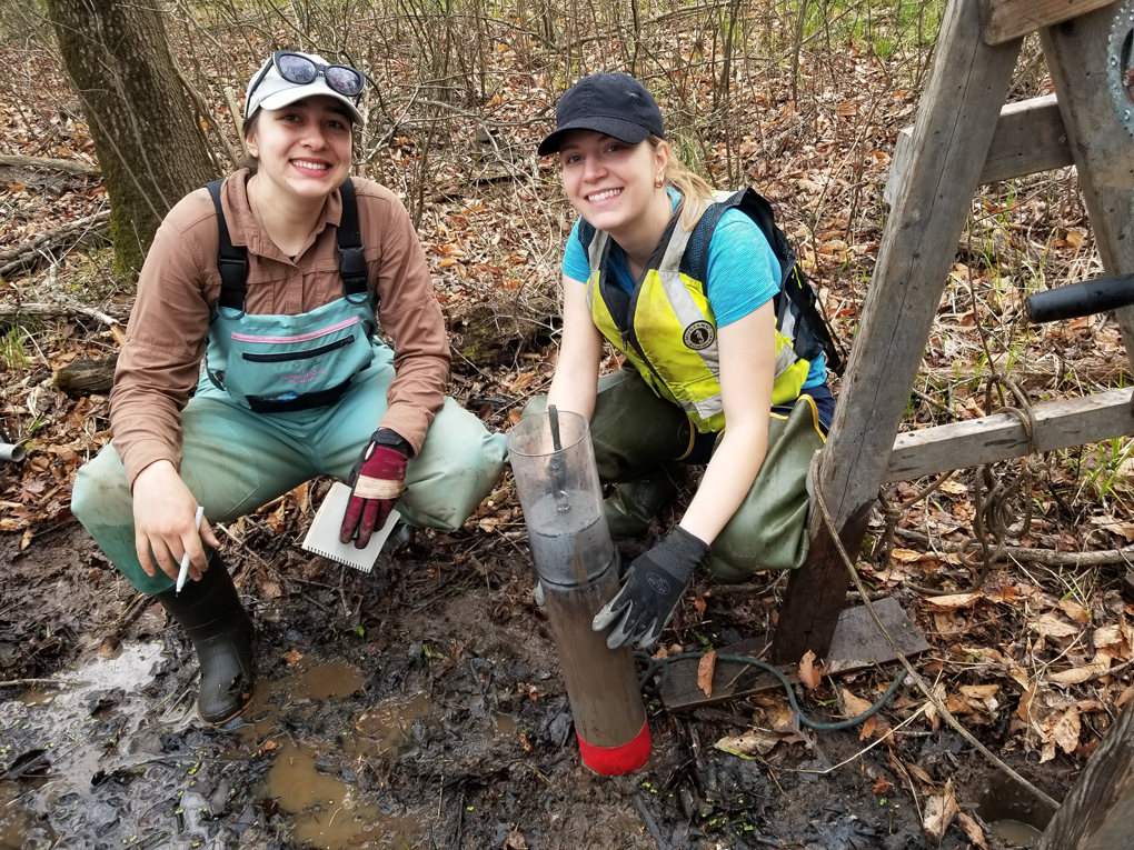
U.S. Geological Survey (USGS) collaborators Simone Gibson (USGS Woods Hole Coastal and Marine Science Center) and Molly Huber (USGS Florence Bascom Geoscience Center) collecting a sediment core from a forested freshwater wetland for age-dating analysis. Photograph by the U.S. Geological Survey.
Information Science
Data collected for analysis by USGS scientists are in demand by scientists at other agencies and universities; resource managers and policymakers at Federal, State, and local levels; and the public. The Information Science group at the center is responsible for managing and maintaining the scientific data, ensuring that they are readily available in a variety of formats and online systems. The group also assists stakeholders in understanding their data needs and locating useful products.
Additionally, members of this group produce physical and electronic information products, manage social media accounts, highlight research efforts by writing articles and social media posts, organize and participate in outreach activities, and maintain the center’s web presence.
2022 by the Numbers
-
• 135 information products initiated in the USGS Information Product Data System
-
• 25 journal articles approved for publication
-
• 38 abstracts approved for presentations at professional meetings
-
• 30 data releases made available to the public and over 75 accompanying metadata records
-
• 107 social media posts
Follow us!
Facebook: @USGScoastalandoceanscience
Twitter: @USGScoastchange
-
• 160 8-millimeter tapes read to transfer raw digital data from aging storage media to computer hard drive
Data Management and Preservation
Highlights of 2022
Good data management is vital for the sharing and reuse of data collected and published by USGS scientists. Good data management also reduces data redundancy and costs in terms of time and money. Well-documented data that are easily accessed may be integrated readily into a new project or dataset. Best practices of data management attempt to define, document, and use consistent standards and procedures. The goal is to provide the information resources needed for efficient program operations. Staff at the WHCMSC collaborate with the other Coastal and Marine Hazards and Resources Program centers to provide consistency within data management activities.
The Information Science group has developed 15 guidelines that describe data and metadata that are findable, accessible, interoperable, and reusable (FAIR). Data that are aligned with the FAIR Principles are ready to be used in automated analysis and modeling processes that integrate multidisciplinary data and research results to analyze and predict complex interactions among human and earth systems.
The data library at WHCMSC preserves and makes available a rich repository of scientific data spanning many decades of USGS research in Woods Hole. In addition, the data library includes records that document project activities and provide contextual information for the data that were produced. These include field notes, cruise logs, navigation records, and photographs.
Published FAIR Roadmap
A member of the Information Science group led a team of authors that published recommendations to improve the alignment of all USGS data with the principles of being findable, accessible, interoperable, and reusable (FAIR Principles). The resulting FAIR roadmap consists of nine strategies that include actions to support USGS data producers in adhering to the FAIR Principles. The roadmap will improve the USGS infrastructure of information systems and policy and provide USGS employees with information about the methods and benefits of the FAIR Principles.
White Paper on Modernizing the Data Library
A new staff member joined the data library after completing a master of library and information science degree. Her first accomplishment was “Modernizing the Woods Hole Coastal and Marine Center Data Library,” a white paper offering options and priorities as well as references for methods and best practices.
Continued Converting At-Risk Media
The data library continued converting data stored on at-risk media, such as 8-millimeter tapes, CD-ROMs, DVDs, and Jaz disks. Data conversion is made possible by equipment provided by the Sea Floor Mapping Group, as well as their expertise in troubleshooting and resolving issues in accessing the data on the media. So far, the effort has rescued over 115 gigabytes of raw data from 16 field activities occurring between 1991 and 2000.
Diversity, Equity, and Inclusion in Woods Hole
At the WHCMSC, we are committed to improving diverse representation and equity in science for the long haul. We invest time and resources to identify and address blind spots and build an inclusive culture, and we assess and correct our course regularly. Addressing systemic racism, microaggressions, and attitudes of apathy, skepticism, and resignation within the science community toward such efforts is crucial to the future vitality and viability of the USGS as an earth science agency serving the Nation.
The WHCMSC has long promoted diversity, equity, and inclusion in its many forms. In 2004, the six Woods Hole science institutions formed the Woods Hole Diversity Initiative and committed to attracting and retaining a more diverse workforce. The Woods Hole Diversity Initiative in turn established the Woods Hole Diversity Advisory Committee, made up of representatives from each organization, to recommend how the institutions can make the village of Woods Hole more diverse and inclusive. The committee plans events for Black History Month, Native American Heritage Month, and Juneteenth; hosts community discussions; supports events of the lesbian, gay, transgender, queer/questioning, intersex, asexual/ally, plus more (LGBTQIA+) community; and more.
In 2022, the Partnership Education Program—a 10-week residential program for college juniors and seniors from groups underrepresented in the marine and coastal sciences who want to gain practical, scientific experience—welcomed its 14th class. This year, WHCMSC hosted two students through this program. The center’s partnership program with the City College of New York entered its 18th year. Though no City College of New York interns were present in Woods Hole in 2022, this partnership program places student interns at USGS centers across the country.
Additionally, several WHCMSC staff members continue to represent the USGS Peer Support Worker Program. This program was created to promote awareness and provide outreach and education on topics and policies related to antiharassment, discrimination, biases, and scientific integrity.
2022 Diversity Activity Highlights
Peer Support Worker Program
The WHCMSC’s Peer Support Workers organized the Bystander Intervention Part 2 training with Right To Be (formerly Hollaback!) at the request of center staff. The Peer Support Workers rereleased a “Customizing Bystander Intervention” form to collect scenarios that could be discussed during the training.
Woods Hole Diversity Advisory Committee
The Woods Hole Diversity Advisory Committee organized numerous events in 2022, including the following:
-
• A Juneteenth Celebration, including a lecture by B. Chad Starks of BCS and Associates, Inc. and a contemplative freedom walk
-
• The Ambrose Jearld, Jr. Lecture titled “New Scientists for A New America in A New Normal,” by Dr. Orlando Taylor of the Center for the Advancement of STEM Leadership Fielding Graduate University, Santa Barbara, California
-
• A series of events in celebration of Black History Month, including a virtual book reading, “Human Nature” film screening in partnership with the Woods Hole Film Festival, a yoga workshop, a panel discussion about closing the racial gap in swimming skills and water competency, a well-being and mental health workshop centering on the Black community, and other health and well-being-related lectures
-
• Celebration of Native American Heritage Month, including a presentation titled “Indigenous Science in the Era of Climate Change,” by Dr. Jessica Hernandez, transnational Indigenous scholar, scientist, and community advocate, a Wampanoag Nation Singers and Dancers event, and a book discussion
-
• The Woods Hole Summer Student Barbecue
2022 Student and Early Career Mentorships
Scientists at the center mentor students and recent graduates through programs such as the Woods Hole Oceanographic Institution (WHOI) Summer Student Fellowship (SSF), the Woods Hole Partnership Education Program (PEP), the City College of New York/City University of New York partnership, and the USGS/National Association of Geoscience Teachers Cooperative Summer Field Training Program (CSFTP). Through these mentorships, students and early career scientists gain experience, advance skills, and interact socially and scientifically with their cohorts and the Woods Hole community.
Thanks to the dedication of the mentors and the directors of these programs, it was another successful season of student and early career mentorships. After two years of working with mentees virtually, a highlight of this season was having mentees in person throughout the summer and beyond. In celebration, the Woods Hole Diversity Advisory Committee organized the Woods Hole Summer Student Barbecue, an event for the summer students, early career mentees, and their mentors working at all the science institutions throughout Woods Hole. It was attended by about 150 people and provided a great opportunity for participants to make connections, reflect on their hard work, and have fun! Additionally, the center organized a Federal Career Panel for the mentees, in collaboration with the National Oceanic and Atmospheric Administration (NOAA) Northeast Fisheries Science Center. Multidisciplinary USGS and NOAA scientists at career stages ranging from less than a year in Federal service to over 20 years discussed various pathways to Federal science careers, as well as challenges and highlights of their work.
-
Tyvonta Johnson (PEP)
Mentor: Elizabeth Pendleton
-
Rachel Einecker (SSF)
Mentor: Meagan Eagle
-
Lilian Lucas (SSF)
Mentors: Uri ten Brink, Jason Chaytor, and Claudia Flores
-
Zachary Taylor (PEP)
Mentor: Meagan Eagle
-
Simone Gibson (CSFTP)
Mentor: Meagan Eagle
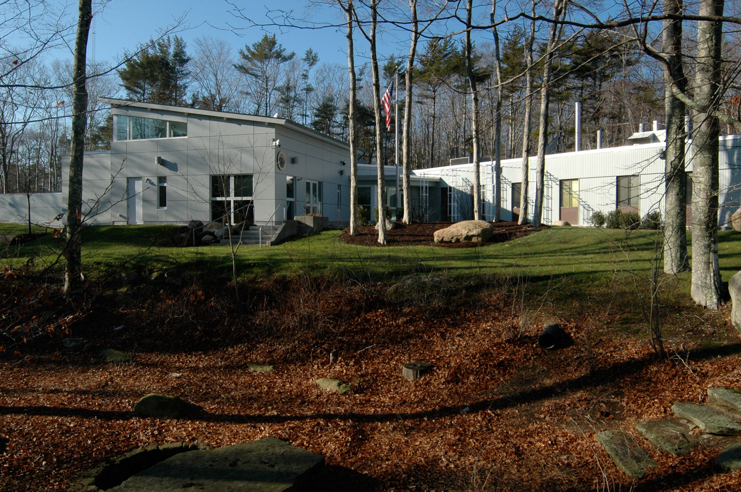
Woods Hole Coastal and Marine Science Center. Photograph by the U.S. Geological Survey.
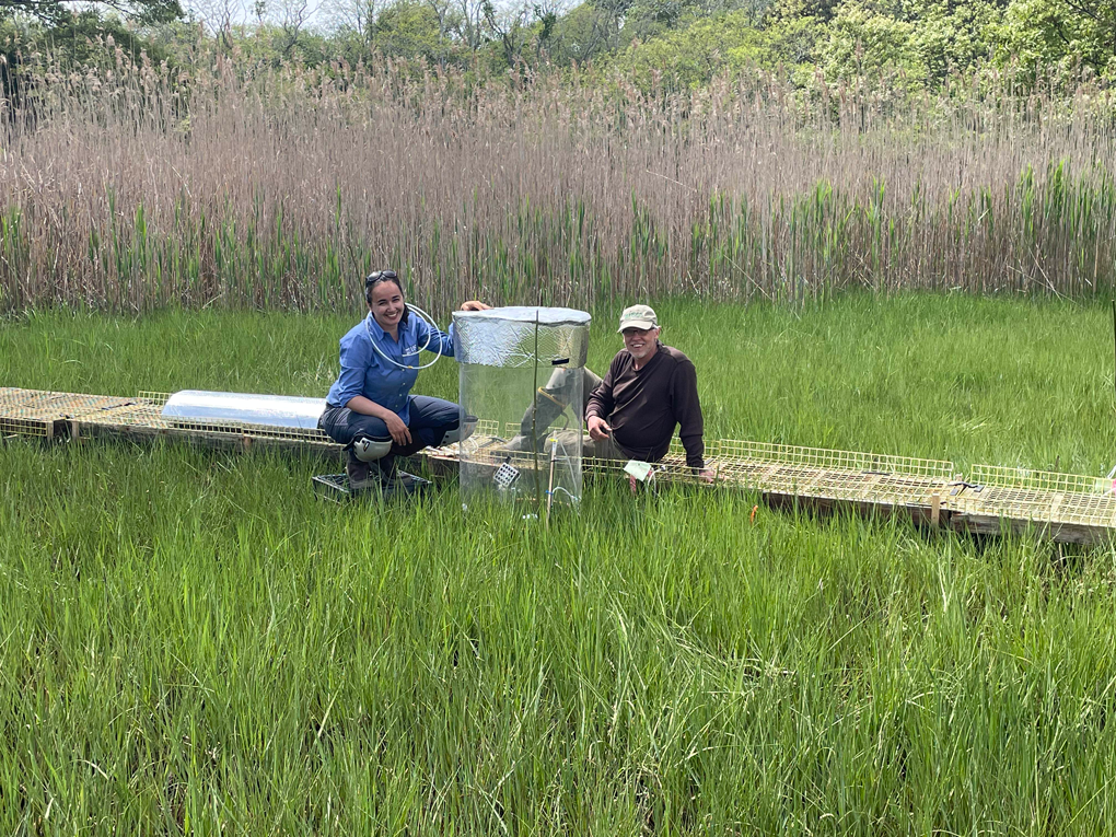
U.S. Geological Survey Woods Hole Coastal and Marine Science Center scientists Rebecca Sanders-DeMott and Kevin Kroeger measure carbon dioxide and methane exchange between a salt marsh ecosystem and the atmosphere. The experiment, as part of the Herring River restoration project in the Cape Cod National Seashore, is a first field trial for carbon dioxide removal and ocean alkalinity enhancement through olivine mineral addition to salt marsh soil. Photograph by the U.S. Geological Survey.
2022 Publications
Journal Articles (31)
Brankovits, D., Pohlman, J.W., and Lapham, L.L., 2022, Oxygenation of a karst subterranean estuary during a tropical cyclone—Mechanisms and implications for the carbon cycle: Limnology and Oceanography, v. 67, no. 12, p. 2691–2705, https://doi.org/10.1002/lno.12231.
Carey, J.C., Kroeger, K.D., and Tang, J., 2022, Higher temperature sensitivity of ecosystem respiration in low marsh compared to high elevation marsh ecosystems: Journal of Geophysical Research. Biogeosciences, v. 127, no. 11, article e2022JG006832, https://doi.org/10.1029/2022JG006832.
Castagno, K.A., Ganju, N.K., Beck, M.W., Bowden, A.A., and Scyphers, S.B., 2022, How much marsh restoration is enough to deliver wave attenuation coastal protection benefits?: Frontiers in Marine Science, v. 8, article 756670, https://doi.org/10.3389/fmars.2021.756670.
Eagle, M.J., Kroeger, K.D., Spivak, A.C., Wang, F., Tang, J., Abdul-Aziz, O.I., Ishtiaq, K.S., O’Keefe-Suttles, J.A., and Mann, A.G., 2022, Soil carbon consequences of historic hydrologic impairment and recent restoration in coastal wetlands: Science of the Total Environment, v. 848, article 157682, https://doi.org/10.1016/j.scitotenv.2022.157682.
Fang, Y., Flemings, P.B., Daigle, H., Phillips, S.C., and O’Connell, J., 2022, Permeability of methane hydrate-bearing sandy silts in the deep-water Gulf of Mexico (Green Canyon Block 955): AAPG Bulletin, v. 106 no. 5, p. 1071–1100, https://doi.org/10.1306/08102121001.
Fang, Y., Flemings, P.B., Germaine, J.T., Daigle, H., Phillips, S.C., and O’Connell, J., 2022, Compression behavior of hydrate-bearing sediments: AAPG Bulletin, v. 106, no. 5, p. 1101–1126, https://doi.org/10.1306/01132221002.
Fouse, J.A., Eagle, M.J., Kroeger, K.D., and Smith, T.P., 2022, Estimating the aboveground biomass and carbon stocks of tall shrubs in a prerestoration degraded salt marsh: Restoration Ecology, v. 31, no. 1, article e13684, https://doi.org/10.1111/rec.13684.
Ganju, N.K., Couvillion, B.R., Defne, Z., and Ackerman, K.V., 2022, Development and application of Landsat-based wetland vegetation cover and unvegetated-vegetated marsh ratio (UVVR) for the conterminous United States: Estuaries and Coasts, v. 45, p. 1861–1878, https://doi.org/10.1007/s12237-022-01081-x.
Gutierrez, B.T., Zeigler, S.L., Lentz, E.E., Sturdivant, E.J., and Plant, N.G., 2022, Integrating Bayesian networks to forecast sea-level rise impacts on barrier island characteristics and habitat availability: Earth and Space Science, v. 9, no. 11, article e2022EA002286, https://doi.org/10.1029/2022EA002286.
He, R., Wang, J., Pohlman, J.W., Jia, Z., Chu, Y.-X., Wooller, M.J., and Leigh, M.B., 2022, Metabolic flexibility of aerobic methanotrophs under anoxic conditions in Arctic lake sediments: The ISME Journal, v. 16, p. 78–90, https://doi.org/10.1038/s41396-021-01049-y.
Hegermiller, C.A., Warner, J.C., Olabarrieta, M., Sherwood, C.R., and Kalra, T.S., 2022, Modeling of barrier breaching during Hurricanes Sandy and Matthew: Journal of Geophysical Research: Earth Surface, v. 127, no. 3, article e2021JF006307, https://doi.org/10.1029/2021JF006307.
Jang, J., Waite, W.F., Stern, L.A., and Lee, J.Y., 2022, Diatom influence on the production characteristics of hydrate-bearing sediments—Examples from Ulleung Basin, offshore South Korea: Marine and Petroleum Geology, v. 144, article 105834, https://doi.org/10.1016/j.marpetgeo.2022.105834.
Johnson, J.E., MacLeod, D.R., Phillips, S.C., Purkey Phillips, M., and Divins, D.L., 2022, Primary deposition and early diagenetic effects on the high saturation accumulation of gas hydrate in a silt dominated reservoir in the Gulf of Mexico: Marine Geology, v. 444, article 106718, https://doi.org/10.1016/j.margeo.2021.106718.
Joung, D., Ruppel, C.D., Southon, J., Weber, T.S., and Kessler, J.D., 2022, Negligible atmospheric release of methane from decomposing hydrates in mid-latitude oceans: Nature Geoscience, v. 15, no. 11, p. 885–891, https://doi.org/10.1038/s41561-022-01044-8.
Kalra, T.S., Suttles, S.E., Sherwood, C.R., Warner, J.C., Aretxabaleta, A.L., and Leavitt, G.R., 2022, Shoaling wave shape estimates from field observations and derived bedload sediment rates: Journal of Marine Science and Engineering, v. 10, no. 2, article 223, https://doi.org/10.3390/jmse10020223.
Lang, G., and ten Brink, U.S., 2022, Quantifying permanent uplift due to lithosphere-hotspot interaction: Tectonics, v. 41, no. 12, article e2022TC007448, https://doi.org/10.1029/2022TC007448.
Lundine, M.A., Brothers, L.L., and Trembanis, A.C., Deep learning for pockmark detection—Implications for quantitative seafloor characterization: Geomorphology, v. 421, article 108524, https://doi.org/10.1016/j.geomorph.2022.108524.
Majumdar, U., Miller, N.C., and Ruppel, C.D., 2022, Neural net detection of seismic features related to gas hydrates and free gas accumulations on the northern U.S. Atlantic margin: Interpretation, v. 10, no. 4, p. T785–T806, https://doi.org/10.1190/INT-2021-0248.1.
Phillips, S.C., Flemings, P.B., You, K., and Waite, W.F., 2022, Thermodynamic insights into the production of methane hydrate reservoirs from depressurization of pressure cores: AAPG Bulletin, v. 5, no. 106, p. 1025–1049, https://doi.org/10.1306/08182120216.
Proveyer, L.V., Sierra-Lorenzo, M., Cruz-Rodriguez, R.C., and Warner, J.C., 2022, Analysis of ocean dynamics during the impact of Hurricane Matthew using ocean-atmosphere coupling: Cuban Journal of Meteorology (Revista Cubana de Meteorología), v. 28, no. 1, https://cu-id.com/2377/v28n1e05.
Proveyer, L.V., Sierra Lorenzo, M., Cruz Rodriguez, R.C., and Warner, J.C., 2022, Impacts of the ocean-atmosphere coupling into the very short range prediction system, during the impact of Hurricane Matthew on Cuba: Ciência e Natura, v. 44, article e3, https://doi.org/10.5902/2179460X66169.
Riedel, M., Scherwath, M., Romer, M., Paull, C.K., Lundsten, E.M., Caress, D., Brewer, P.G., Pohlman, J.W., Lapham, L.L., Chapman, N.R., Witicar, M.J., Spence, G.D., Enkin, R.J., and Douglas, K., 2022, Barkley canyon gas hydrates—A synthesis based on two decades of seafloor observation and remote sensing: Frontiers in Earth Science, v. 10, article 852853, https://doi.org/10.3389/feart.2022.852853.
Ruppel, C.D., Weber, T.C., Staaterman, E.R., Labak, S.J., and Hart, P.E., 2022, Categorizing active marine acoustic sources based on their potential to affect marine animals: Journal of Marine Science and Engineering, v. 10, no. 9, article 1278, https://doi.org/10.3390/jmse10091278.
Sanders-DeMott, R., Eagle, M.J., Kroeger, K.D., Wang, F., Brooks, T.W., O’Keefe-Suttles, J.A., Nick, S.K., Mann, A.G., and Tang, J., 2022, Impoundment increases methane emissions in Phragmites-invaded coastal wetlands: Global Change Biology, v. 28, no. 15, p. 4539–4557, https://doi.org/10.1111/gcb.16217.
Tamborski, J.J., Cai, P., Eagle, M.J., Henderson, P., and Charette, M.A., 2022, Revisiting 228Th as a tool for determining sedimentation and mass accumulation rates: Chemical Geology, v. 607, article 121006, https://doi.org/10.1016/j.chemgeo.2022.121006.
Williams, O.L., Kurtz, A.C., Eagle, M.J., Kroeger, K.D., Tamborski, J.J., and Carey, J.C., 2022, Mechanisms and magnitude of dissolved silica release from a New England salt marsh: Biogeochemistry, v. 161, no. 3, p. 251–271, https://doi.org/10.1007/s10533-022-00976-y.
Xu, Y., Kalra, T.S., Ganju, N.K., and Fagherazzi, S., 2022, Modeling the dynamics of salt marsh development in coastal land reclamation: Geophysical Research Letters, v. 49, no. 6, https://doi.org/10.1029/2021GL095559.
Yang, X., Zhu, Z., Qiu, S., Kroeger, K.D., Zhu, Z., and Covington, S., 2022, Detection and characterization of coastal tidal wetland change in the northeastern US using Landsat time series: Remote Sensing of Environment, v. 276, article 113047, https://doi.org/10.1016/j.rse.2022.113047.
Yin, D., Xue, Z.G., Bao, D., RafieeiNasab, A., Huang, Y., Morales, M., and Warner, J.C., 2022, Understanding the role of initial soil moisture and precipitation magnitude in flood forecast using a hydrometeorological modeling system: Hydrological Processes, v. 36, no. 10, article e14710, https://doi.org/10.1002/hyp.14710.
Yoneda, J., Jin, Y., Muraoka, M., Oshima, M., Suzuki, K., Waite, W.F., and Flemings, P.B., 2022, Comprehensive pressure core analysis for hydrate-bearing sediments from Gulf of Mexico Green Canyon Block 955, including assessments of geomechanical viscous behavior and NMR permeability: AAPG Bulletin, v. 106, no. 5, p. 1143–1177, https://doi.org/10.1306/04272120204.
Zeigler, S.L., Gutierrez, B.T., Lentz, E.E., Plant, N.G., Sturdivant, E.J., and Doran, K.S., 2022, Predicted sea-level rise-driven biogeomorphological changes on Fire Island, New York—Implications for people and plovers: Earth's Future, v. 10, no. 4, article e2021EF002436, https://doi.org/10.1029/2021EF002436.
U.S. Geological Survey Series Publications (4)
Andrews, B.D., Brothers, D.S., Dartnell, P., Barrie, J.V., Haeussler, P.J., Green, K.M., Greene, H.G., Miller, N.C., Kluesner, J.W., and ten Brink, U.S., 2022, Systematic mapping of the ocean-continent transform plate boundary of the Queen Charlotte fault system, southeastern Alaska and western British Columbia—A preliminary bathymetric terrain model: U.S. Geological Survey Open-File Report 2022–1085, 2 sheets, 7-p. pamphlet, https://doi.org/10.3133/ofr20221085.
Buczkowski, B.J., 2022, Collections management plan for the U.S. Geological Survey Woods Hole Coastal and Marine Science Center samples repository: U.S. Geological Survey Scientific Investigations Report 2022–5106, 13 p., https://doi.org/10.3133/sir20225106. [Supersedes U.S. Geological Survey Open-File Reports 2006–1187 and 2018–1100.]
Ernst, S., 2022, Woods Hole Coastal and Marine Science Center—2021 annual report: U.S. Geological Survey Circular 1495, 32 p., https://doi.org/10.3133/cir1495.
Lightsom, F.L., Hutchison, V.B., Bishop, B., Debrewer, L.M., Govoni, D.L., Latysh, N., and Stall, S., 2022, Opportunities to improve alignment with the FAIR Principles for U.S. Geological Survey data: U.S. Geological Survey Open-File Report 2022–1043, 23 p., https://doi.org/10.3133/ofr20221043.
Data Releases (38)
Ackerman, K.V., Defne, Z., and Ganju, N.K., 2022, Geospatial characterization of salt marshes in Chesapeake Bay: U.S. Geological Survey data release, https://doi.org/10.5066/P997EJYB.
Ackerman, S.D., Foster, D.S., Andrews, B.D., Danforth, W.W., Baldwin, W.E., Huntley, E.C., Worley, C.R., and Brothers, L.L., 2022, High-resolution geophysical and geological data collected in Cape Cod Bay, Massachusetts during USGS Field Activities 2019-002-FA and 2019-034-FA: U.S. Geological Survey data release, https://doi.org/10.5066/P99DR4PN.
Ackerman, S.D., Foster, D.S., Andrews, B.D., Danforth, W.W., Baldwin, W.E., Huntley, E.C., Worley, C.R., and Brothers, L.L., 2022, High-resolution geophysical and geological data collected in Cape Cod Bay, Massachusetts during USGS Field Activities 2019-002-FA and 2019-034-FA (ver. 2.0, September 2022): U.S. Geological Survey data release, https://doi.org/10.5066/P99DR4PN.
Andrews, B.D., Barnhardt, W.A., Moore, E.A., Nichols, A.R., Ackerman, S.D., and Berube, P.J., 2022, High-resolution geophysical data collected in the vicinity of Buffalo Reef, Michigan, within Lake Superior, U.S. Geological Survey Field Activity 2021-005-FA: U.S. Geological Survey data release, https://doi.org/10.5066/P9NJY125.
Andrews, B.D., Brothers, D.S., Dartnell, P., and Barrie, V.J., 2022, A bathymetric terrain model of multibeam data collected between 2005 and 2018 along the Queen Charlotte Fault System in the Eastern Gulf of Alaska from Cross Sound, Alaska to Queen Charlotte Sound, Canada: U.S. Geological Survey data release, https://doi.org/10.5066/P9YGDHIQ.
Andrews, B.D., Brothers, D.S., ten Brink, U.S., Kluesner, J.W., Haeussler, P.J., Wyland, R.M., and Currie, J.E., 2022, Multibeam bathymetric and backscatter data collected in the eastern Gulf of Alaska along the Queen Charlotte Fault, U.S. Geological Survey Field Activity 2016-625-FA: U.S. Geological Survey data release, https://doi.org/10.5066/P9BTWEXK.
Aretxabaleta, A.L., Defne, Z., Kalra, T.S., Blanton, B.O., and Ganju, N.K., 2022, Climatological wave height, wave period and wave power along coastal areas of the East Coast of the United States and Gulf of Mexico: U.S. Geological Survey data release, https://doi.org/10.5066/P9HJ0JIQ.
Bales, R.D., Over, J.R., Sherwood, C.R., Olson, A.J., Randall, N.R., and Suttles, S.E., 2022, Grain-size analysis data of sediment samples from the beach and nearshore environments at the Pea Island National Wildlife Refuge DUNEX site, North Carolina in 2021: U.S. Geological Survey data release, https://doi.org/10.5066/P9XEFRYR.
Balster-Gee, A.F., Baldwin, W.E., and Hart, P.E., 2022, Calibrated marine sparker source amplitude decay versus offset offshore Santa Cruz, California: U.S. Geological Survey data release, https://doi.org/10.5066/P9EHITBI.
Balster-Gee, A.F., Brothers, D.S., Kluesner, J.W., Miller, N.C., Haeussler, P.J., O’Brien, T.F., Marcuson, R.K., Hart, P.E., Conrad, J.E., Walton, M.A.L., and Nichols, A.R., 2022, Multichannel sparker and chirp seismic reflection data collected offshore South East Alaska during USGS Field Activity 2017-621-FA: U.S. Geological Survey data release, https://doi.org/10.5066/P9QXL00L.
Barth, G.A., Baldwin, W.E., Reece, R.S., Gulick, S.S., Danforth, W.W., and Wong, F.L., 2022, Multibeam bathymetry and acoustic backscatter from the Alaskan region, Extended Continental Shelf Project, 2011 field season—Gulf of Alaska and Bering Sea: U.S. Geological Survey data release, https://doi.org/10.5066/F7HM56HK.
Brankovits, D., Pohlman, J.W., Lapham, L.L., Casso, M., Mann, A.G., and O’Keefe-Suttle, J.A., 2022, Water column properties and temporal hydrologic and chemical records from flooded caves (Ox Bel Ha and Cenote Crustacea) within the coastal aquifer of the Yucatan Peninsula, Quintana Roo, from December 2013 to January 2015: U.S. Geological Survey data release, https://doi.org/10.5066/P91D2OUN.
Brooks, T.W., Eagle, M., Kroeger, K.D., Mann, A.G., Wang, Z.A., Ganju, N.K., O’Keefe Suttles, J.A., Brosnahan, S.M., Chu, S.N., Song, S., Pohlman, J.W., Casso, M., Tamborski, J.J., Morkeski, K., Carey, J.C., Ganguli, P.M., Williams, O.L., and Kurtz, A.C., 2022, Geochemical data supporting investigation of solute and particle cycling and fluxes from two tidal wetlands on the south shore of Cape Cod, Massachusetts, 2012-19 (ver. 2.0, October 2022): U.S. Geological Survey data release, https://doi.org/10.5066/P9MXLUZ1.
Cramer, J.C., Huntley, E.C., Brosnahan, S.M., Ganju, N.K., Sturdivant, E.J., Pendleton, E.A., Ackerman, S.D., and Borden, J., 2022, Aerial imagery and ground control points collected during an uncrewed aerial systems (UAS) survey at Plum Island Estuary and Parker River NWR (PIEPR), November 14, 2017 and March 28, 2019: U.S. Geological Survey data release, https://doi.org/10.5066/P9PP35F4.
Dartnell, P., Brothers, D.S., and Andrews, B.D., 2022, Multibeam bathymetry and acoustic-backscatter data collected in 2017 and 2018 of Noyes Submarine Canyon and vicinity, southeast Alaska: U.S. Geological Survey data release, https://doi.org/10.5066/P9AU5I03.
De Meo, O.A., Suttles, S.E., Ganju, N.K., and Marsjanik, E.D., 2022, Suspended-sediment concentrations and loss-on-ignition from water samples collected in the Herring River during 2018-19 in Wellfleet, MA: U.S. Geological Survey data release, https://doi.org/10.5066/P9ZL2IPN.
Ganju, N.K., and Defne, Z., 2022, Lifespan of marsh units in Assateague Island National Seashore and Chincoteague Bay, Maryland and Virginia: U.S. Geological Survey data release, https://doi.org/10.5066/P9WSYCAN.
Hegermiller, C.A., Warner, J.C., Olabarrieta, M., Sherwood, C.R., and Kalra, T.S., 2022, U.S. Geological Survey simulations of hydrodynamics and morphodynamics at Matanzas, FL during Hurricane Matthew (2016) and at Fire Island, NY during Hurricane Sandy (2012): U.S. Geological Survey data release, https://doi.org/10.5066/P9CKGQTX.
Jang, J., Waite, W.F., Stern, L.A., and Lee, J.Y., 2022, Dataset of diatom controls on the compressibility and permeability of fine-grained sediment collected offshore of South Korea during the Second Ulleung Basin Gas Hydrate Expedition, UBGH2: U.S. Geological Survey data release, https://doi.org/10.5066/P9ZLO4IM.
Jang, J., Waite, W.F., Stern, L.A., and Lee, J.Y., 2022, Dataset of diatom controls on the sedimentation behavior of fine-grained sediment collected offshore of South Korea during the Second Ulleung Basin Gas Hydrate Expedition, UBGH2: U.S. Geological Survey data release, https://doi.org/10.5066/P9S6S24N.
Kranenburg, C.J., Ritchie, A.C., Brown, J.A., Over, J.R., Sherwood, C.R., Warrick, J.A., and Wernette, P.A., 2022, Aerial imagery of the North Carolina coast—2019-10-11: U.S. Geological Survey data release, https://doi.org/10.5066/P9RRSMOJ.
Kranenburg, C.J., Ritchie, A.C., Brown, J.A., Over, J.R., Sherwood, C.R., Warrick, J.A., and Wernette, P.A., 2022, Aerial imagery of the North Carolina coast—2019-11-26: U.S. Geological Survey data release, https://doi.org/10.5066/P99TL46N.
Kranenburg, C.J., Ritchie, A.C., Brown, J.A., Over, J.R., Sherwood, C.R., Warrick, J.A., and Wernette, P.A., 2022, Aerial imagery of the North Carolina coast—2020-02-08 to 2020-02-09: U.S. Geological Survey data release, https://doi.org/10.5066/P9ISFCVN.
Kranenburg, C.J., Ritchie, A.C., Brown, J.A., Over, J.R., Sherwood, C.R., Warrick, J.A., and Wernette, P.A., 2022, Aerial imagery of the North Carolina coast—2020-05-08 to 2020-05-09: U.S. Geological Survey data release, https://doi.org/10.5066/P9OCDOYZ.
O’Keefe Suttles, J.A., Eagle, M.J., Martin, R.M., Moseman-Valtierra, S., and Kroeger, K.D., 2022, Static chamber gas fluxes and carbon and nitrogen isotope content of age-dated sediment cores from a Phragmites wetland in Sage Lot Pond, Massachusetts, 2015: U.S. Geological Survey data release, https://doi.org/10.5066/P9JM751N.
O’Keefe Suttles, J.A., Eagle, M.J., Sanders-DeMott, R., Nick, S., Brooks, T.W., Mann, A.G., and Kroeger, K.D., 2022, Continuous water level, salinity, and temperature data from coastal wetland monitoring wells, Cape Cod, Massachusetts: U.S. Geological Survey data release, https://doi.org/10.5066/P9T1KOTW.
O’Keefe Suttles, J.A., Eagle, M.J., Sanders-DeMott, R., Nick, S.K., Brooks, T.W., Mann, A.G., and Kroeger, K.D., 2022, Continuous water level, salinity, and temperature data from coastal wetland monitoring wells, Cape Cod, Massachusetts (ver. 2.0, August 2022): U.S. Geological Survey data release, https://doi.org/10.5066/P9T1KOTW.
Over, J.R., Sherwood, C.R., and Traykovski, P., 2022, Topographic and bathymetric data, structure from motion imagery, and ground control data collected at Head of the Meadow Beach, Truro in March 2022, U.S. Geological Survey Field Activity 2022-015-FA: U.S. Geological Survey data release, https://doi.org/10.5066/P9GEVWG1.
Over, J.R., Sherwood, C.R., and Traykovski, P., 2022, Topographic and bathymetric data, structure from motion imagery, and ground control data collected at Head of the Meadow, Truro in February 2021, U.S Geological Survey Field Activity 2021-014-FA: U.S. Geological Survey data release, https://doi.org/10.5066/P9D94NZ3.
Over, J.R., Sherwood, C.R., Traykovski, P., and Bartlett, M.K., 2022, Topographic and bathymetric data, structure from motion imagery, and ground control data collected at Marconi Beach, Wellfleet, MA in March 2022, U.S Geological Survey Field Activity 2022-014-FA: U.S. Geological Survey data release, https://doi.org/10.5066/P9L1KCQB.
Over, J.R., Sherwood, C.R., Traykovski, P.A., Olson, A.J., Randall, N.R., and Brosnahan, S.M., 2022, DUNEX topographic, bathymetric, and supporting GPS data collected in Pea Island National Wildlife Refuge, North Carolina 2020-2021: U.S. Geological Survey data release, https://doi.org/10.5066/P9DPZZG2.
Prouty, N.G., and Chaytor, J.D., 2022, Carbonate chemistry measurements of authigenic carbonates collected offshore the U.S. Mid- and South Atlantic in 2018 and 2019 as part of the DEEPSEARCH Project: U.S. Geological Survey data release, https://doi.org/10.5066/P9DRU8TP.
Ritchie, A.C., Over, J.R., Kranenburg, C.J., Brown, J.A., Buscombe, D.D., Sherwood, C.R., Warrick, J.A., and Wernette, P.A., 2022, Aerial photogrammetry data and products of the North Carolina coast: U.S. Geological Survey data release, https://doi.org/10.5066/P9K3TWY7.
Sanders-DeMott, R., Eagle, M., Kroeger, K., Brooks, W., O’Keefe Suttles, J.A., Nick, S., and Mann, A., 2022, Carbon dioxide and methane fluxes with supporting environmental data from coastal wetlands across Cape Cod, Massachusetts: U.S. Geological Survey data release, https://doi.org/10.5066/P9RRL3T0.
Sanders-DeMott, R., Eagle, M.J., Kroeger, K.D., Wang, F., Brooks, T.W., O’Keefe-Suttles, J.A., Nick, S.K., Mann, A.G., and Tang, J., 2022, Carbon dioxide and methane fluxes with supporting environmental data from coastal wetlands across Cape Cod, Massachusetts (ver. 2.0, June 2022): U.S. Geological Survey data release, https://doi.org/10.5066/P9RRL3T0.
Valentine, P.C., and Cross, V.A., 2022, Station information, seabed and sample imagery, and CTD instrument data collected on Stellwagen Bank from May 2016 to April 2019: U.S. Geological Survey data release, https://doi.org/10.5066/P9ERNGJ2.
Warner, J.C., 2022, U.S. Geological Survey simulations of hydrodynamics and morphodynamics in Cape Cod Bay, MA: U.S. Geological Survey data release, https://doi.org/10.5066/P9I45J6Z.
Warner, J.C., and Kalra, T.S., 2022, Collection of COAWST model forecast for the US East Coast and Gulf of Mexico: U.S. Geological Survey data release, https://doi.org/10.5066/P903KPBJ.
Geonarratives and Other Web Pages (2)
Ernst, S., Cravens, A., Himmelstoss, E., Palmsten, M., Snell, R., and Stoltz, A., 2022, State of our Nation’s coast: U.S. Geological Survey web page, https://www.usgs.gov/natural-hazards/coastal-marine-hazards-and-resources/science/state-our-nations-coast.
Warner, J.C., Defne, Z., Hegermiller, C., Sherwood, C.R., He, R., Zambon, J.B., Xue, G., Bao, D., Yin, D., and Moulton, M., 2022, Hurricane Florence numerical modeling—Coupling hydrology and ocean models to investigate coastal impacts of hurricanes: U.S. Geological Survey web page, https://geonarrative.usgs.gov/florence_2018_modeling/.
Software Releases (2)
Gutierrez, B.T., and Plant, N.G., 2022, LinkedBNs4Habitat—Matlab codes developed to link and run Bayesian networks created with Netica: U.S. Geological Survey software release, https://doi.org/10.5066/P9R63EMY.
McCann, M.P., Anderson, D.L., Sherwood, C.R., Bruder, B., Bak, A.S., and Brodie, K.L., 2022, CoastalImageLib—An open-source Python package for creating common coastal image products: SoftwareX, v. 20, article 101215, https://doi.org/10.1016/j.softx.2022.101215. [Software available directly at https://github.com/ElsevierSoftwareX/SOFTX-D-21-00144.]
Book Chapters (2)
Ruppel, C.D., and Hart, P.E., 2022, Gas hydrates on Alaskan marine margins, in Mienert, J., Berndt, C., Tréhu, A.M., Camerlenghi, A., and Liu, C-S, eds., World atlas of submarine gas hydrates in continental margins: Cham, Switzerland, Springer, p. 209–223, https://doi.org/10.1007/978-3-030-81186-0_17.
Ruppel, C.D., Shedd, W., Miller, N.C., Kluesner, J., Frye, M., and Hutchinson, D., 2022, U.S. Atlantic margin gas hydrates, in Mienert, J., Berndt, C., Tréhu, A.M., Camerlenghi, A., and Liu, C-S, eds., World atlas of submarine gas hydrates in continental margins: Cham, Switzerland, Springer, p. 287–302, https://doi.org/10.1007/978-3-030-81186-0_24.
Abbreviations
AIMG
Aerial Imaging and Mapping Group
CSFTP
Cooperative Summer Field Training Program
COAWST
Coupled Ocean-Atmosphere-Wave-Sediment Transport [modeling system]
DSAS
Digital Shoreline Analysis System
DUNEX
During Nearshore Event Experiment
ECS
extended continental shelf
FAIR
findable, accessible, interoperable, and reusable [principles]
GIS
geographic information system
GPS
Global Positioning System
LGBTQIA+
lesbian, gay, transgender, queer/questioning, intersex, asexual/ally, plus more
NOAA
National Oceanic and Atmospheric Administration
NOPP
National Oceanographic Partnership Program
PEP
Partnership Education Program
SEABOSS
Seabed Observation and Sampling System
SFMG
Sea Floor Mapping Group
SSF
Summer Student Fellowship
TCA
Technical Capabilities and Applications [project]
TWL&CC
Total Water Level and Coastal Change [forecast viewer]
UAS
uncrewed aircraft system
USGS
U.S. Geological Survey
UVVR
unvegetated-vegetated marsh ratio
WHCMSC
Woods Hole Coastal and Marine Science Center
WHOI
Woods Hole Oceanographic Institution
Director, Woods Hole Coastal and Marine Science Center
U.S. Geological Survey
384 Woods Hole Road
Quissett Campus
Woods Hole, MA 02543–1598
WHSC_science_director@usgs.gov
(508) 548–8700 or (508) 457–2200
or visit our website at
Disclaimers
All photographs and other images by the U.S. Geological Survey unless otherwise indicated.
Some text in this report has been retained, with or without modification, from previous annual reports of the Woods Hole Coastal and Marine Science Center of the U.S. Geological Survey.
Any use of trade, firm, or product names is for descriptive purposes only and does not imply endorsement by the U.S. Government.
Although this information product, for the most part, is in the public domain, it also may contain copyrighted materials as noted in the text. Permission to reproduce copyrighted items must be secured from the copyright owner.
Suggested Citation
Ernst, S., 2023, Woods Hole Coastal and Marine Science Center—2022 annual report: U.S. Geological Survey Circular 1513, 36 p., https://doi.org/10.3133/cir1513.
ISSN: 2330-5703 (online)
ISSN: 1067-084X (print)
| Publication type | Report |
|---|---|
| Publication Subtype | USGS Numbered Series |
| Title | Woods Hole Coastal and Marine Science Center—2022 annual report |
| Series title | Circular |
| Series number | 1513 |
| ISBN | 978-1-4113-4536-2 |
| DOI | 10.3133/cir1513 |
| Publication Date | October 17, 2023 |
| Year Published | 2023 |
| Language | English |
| Publisher | U.S. Geological Survey |
| Publisher location | Reston, VA |
| Contributing office(s) | Woods Hole Coastal and Marine Science Center |
| Description | iv, 36 p. |
| Online Only (Y/N) | N |
| Additional Online Files (Y/N) | N |