

The 3D National Topography Model Call for Action—Part 1. The 3D Hydrography Program
Links
- Document: Report (6.98 MB pdf) , HTML , XML
- Version History: Version History (1.42 KB txt)
- Download citation as: RIS | Dublin Core
Abstract
The U.S. Geological Survey is initiating the 3D Hydrography Program (3DHP), the first systematic remapping of the Nation’s surface waters since the original 1:24,000-scale topographic mapping program was active from 1947 to 1992. Building on decades of experience maintaining the National Hydrography Dataset (NHD), the Watershed Boundary Dataset (WBD), and the NHDPlus High-Resolution (NHDPlus HR), the 3DHP will completely refresh the Nation’s hydrography data and improve discovery and sharing of water-related data. The design of the 3DHP is based on the results of a study that estimated that the fully implemented program would have the potential to provide more than $1 billion in benefits to Federal, State, Tribal, Territorial, and local governments and to private and nonprofit organizations every year, in addition to myriad societal benefits. The 3DHP would directly support better decision making regarding water resources by providing more accurate, complete, and integrated information than is currently available.
The 3DHP datasets will include a three-dimensional (3D) hydrography network generated from and integrated with elevation data from the 3D Elevation Program (3DEP) to better represent stream gradients and channel conditions, along with waterbodies, hydrologic units, hydrologically enhanced elevation and other surfaces, and more consistent and accurate attributes. The 3DHP datasets will inherit key attributes of the NHD, WBD, and NHDPlus HR, and they also will include new attributes and links to other data such as the U.S. Fish and Wildlife Service National Wetlands Inventory, groundwater data, and engineered hydrologic systems such as stormwater networks. The 3DHP will be designed to provide a set of open and interoperable web-based tools, maps, and data catalogs, creating a robust system for users to reference their information about water; the system elements are collectively referred to as the “infostructure.” The 3DHP and the infostructure can provide a foundational geospatial underpinning for the Internet of Water, a community-based effort to modernize tools and technologies to share water data. As proposed, the 3DHP would begin providing products and services to the public in 2024.
Introducing the 3D Hydrography Program
The U.S. Geological Survey (USGS) is establishing the 3D Hydrography Program (3DHP) to completely refresh the Nation’s hydrography data and improve discovery and sharing of water-related data. The new program builds on decades of experience in developing and managing the three national hydrography datasets—the National Hydrography Dataset (NHD), the Watershed Boundary Dataset (WBD), and the NHDPlus High Resolution (NHDPlus HR). The implementation of the 3DHP marks the beginning of a new era of water data, and the first systematic remapping of the Nation’s hydrography since the original USGS 1:24,000-scale topographic mapping program for the conterminous United States was active between 1947 and 1992. The data from the 3DHP, along with data from the 3D Elevation Program (3DEP), will be included in the 3D National Topography Model (3DNTM; box 1).
Box 1. 3D National Topography Model
Topography is defined by terrain and water, each influencing and shaping the other. Introduced in the President’s budget for fiscal year 2023 (U.S. Department of the Interior, 2022, p. 127–130), the 3D National Topography Model (3DNTM) is a new initiative that updates, improves, and integrates U.S. Geological Survey elevation and hydrography data to support the most demanding scientific requirements and enable data-driven decisions across user communities.
The 3DNTM is composed of three components: an ongoing effort to complete national baseline datasets, new development of the next-generation hydrography and elevation programs, and a longer term goal to fully integrate hydrography, elevation, and other data from The National Map (https://www.usgs.gov/NationalMap) in a three-dimensional (3D) data model. The transition to an integrated approach to create and manage the 3D Elevation Program and the 3D Hydrography Program will result in higher quality data that are updated more frequently than was possible before.
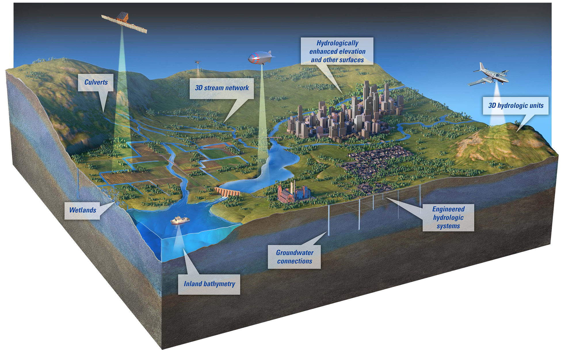
Block diagram showing elevation data being collected over natural and human-made environments. Built using high- resolution 3D Elevation Program and 3D Hydrography Program data, the 3D National Topography Model (3DNTM) will incorporate other critical landscape information such as landcover, structures, transportation, and geology to inform a comprehensive understanding of the landscape to enable data-driven decisions and science. The 3DNTM aspires to augment today’s airborne-acquired elevation data with data acquired from a variety of platforms including satellite, drone, and potentially others. Hydrography data for lakes, rivers, and reservoirs will be derived from that elevation data to form an integrated representation of the landscape that can be connected with other water features such as wetlands and groundwater. The copyrighted base diagram was created by Chuck Carter (of Chuck Carter Media) for the U.S. Geological Survey; used with permission.
When fully implemented, the 3DHP is estimated to have the potential to provide more than $1 billion in benefits to Federal, State, Tribal, Territorial, and local governments and to private and nonprofit organizations every year, in addition to myriad societal benefits (Dewberry, 2016, p. 14). The 3DHP initiative would directly support better decision making across many applications by providing more accurate, complete, and integrated information than is currently available. The next generation of surface-water mapping under the new 3DHP will incorporate the most relevant and impactful components of the existing national hydrography datasets with greatly improved spatial accuracy; thus, it will provide better support for hydrologic modeling and accounting. The resulting products and services will be freely available and freely accessible through modern, widely used open-data standard formats and web services.
The 3DHP is substantially improving the level of detail, currency, and content of hydrography data by deriving (1) three-dimensional (3D) stream network and watershed datasets from high-quality 3D Elevation Program (3DEP; https://www.usgs.gov/3d-elevation-program) data and (2) other elevation-based products to support applications like hydrologic and hydraulic modeling (fig. 1). The 3DHP will improve the ability to track information related to water as it moves through the hydrologic cycle by connecting surface-water features traditionally represented in the NHD to data about wetlands, engineered hydrologic systems, and groundwater. It can also improve the attribution of important hydrologic characteristics such as streamflow permanence.
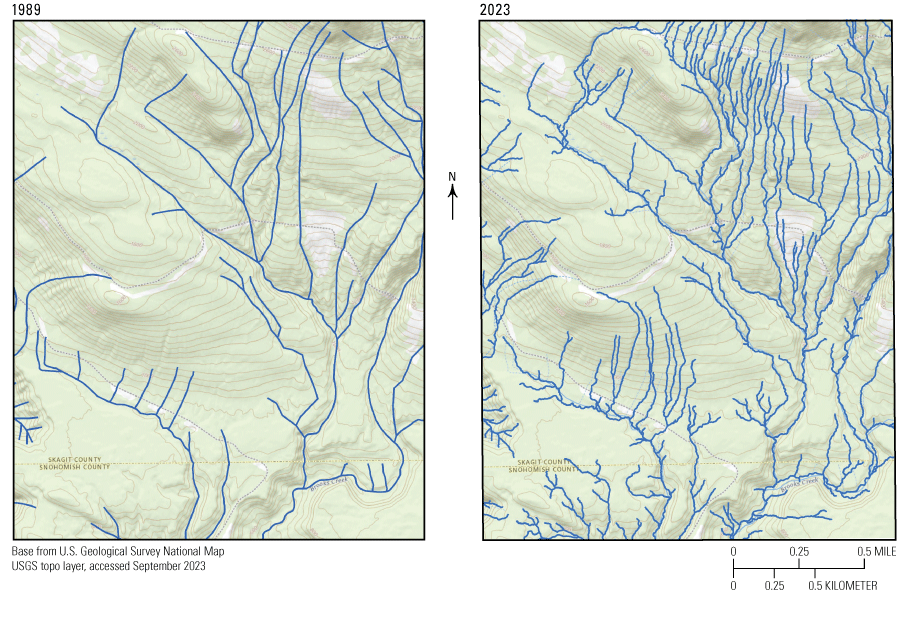
Maps showing the improved alignment possible in the 3D Hydrography Program by using hydrography data derived from high-quality elevation data from the 3D Elevation Program (3DEP). The example maps show topography and streams near the border between Skagit and Snohomish Counties in Washington. The map on the left is from U.S. Geological Survey NHD data derived from the 1989 1:24,000-scale topographic map. The map on the right shows more details of streams and a better alignment of streams with topography that result from using hydrography derived from 3DEP data by the Washington State Hydrography Dataset Program in 2023. NHD, National Hydrography Dataset.
The 3DHP can support an information infrastructure, or “infostructure,” to share and discover water-related data based on the connectivity and flows represented in the improved stream network. The USGS is developing and implementing an operational system, including a modernized data model, to support this vision. In line with the Geospatial Data Act of 2018 (https://www.fgdc.gov/gda/geospatial-data-act-of-2018.pdf) and guidance from the Federal Geographic Data Committee (FGDC; 2021), 3DHP datasets and infostructure are planned to emphasize being FAIR—Findable, Accessible, Interoperable, and Reusable.
As documented in the National Hydrography Requirements and Benefits Study (HRBS; Dewberry, 2016), the 3DHP data and capabilities would allow scientists to more fully model the hydrologic cycle, engineers to make better decisions, water suppliers to improve water quality and availability, disaster response planners to better mitigate natural disasters, and natural resource managers to better protect the environment. The availability of 3DEP data has resulted in new and previously unimagined applications of elevation data. The 3DHP data are expected to be similarly transformative. When 3DHP data are widely available, further private sector and government innovations will follow.
Benefits of Hydrography Data
The HRBS was conducted to document and analyze current and emerging requirements as well as current and future potential benefits of hydrography data. The participants included Federal, State, Tribal, Territorial, and local governments and private and nonprofit organizations. Participants identified $538.5 million in annual benefits from the current national hydrography datasets and estimated an additional $602.55 million in annual benefits if all unmet needs could be satisfied (Dewberry, 2016, p. 14, table 5), for a total of over $1.14 billion in benefits each year. The HRBS results identified many requirements for hydrography data, including better linkage to other water datasets, such as the U.S. Fish and Wildlife Service National Wetlands Inventory (NWI), better positional accuracy, better alignment to elevation data, and more frequent updates, among other findings.
3DHP Datasets
The 3DHP datasets will include a 3D hydrography network generated from and integrated with 3DEP elevation data to better represent stream gradients and channel conditions, along with waterbodies, hydrologic units, hydrologically enhanced elevation and other surfaces, and more consistent and accurate attributes (fig. 2). The 3DHP datasets will be built on high-quality, standardized 3DEP data to ensure spatial and temporal consistency across all derived products. This integration can increase usability of 3DHP datasets for applications like flood modeling and prediction, culvert and bridge engineering design, and stormwater management.
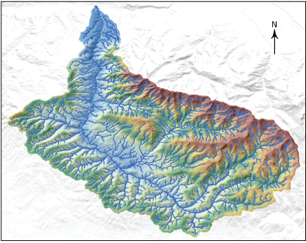
Image showing 3D Hydrography Program data for Canyon Creek watershed, Oregon. The colors indicate elevation from low (blue) to high (brown). Both the colors within the watershed and the shaded relief surrounding the watershed are based on data from the 3D Elevation Program. The blue lines indicate stream locations derived from the elevation data. Figure compiled by Silvia Terziotti, U.S. Geological Survey.
The 3DHP datasets will inherit key attributes of the NHD, WBD, and NHDPlus HR, and they also will include new attributes and links to other data such as the NWI, groundwater data, and information from engineered hydrologic systems such as stormwater networks.
The modernized 3DHP data model includes both the stream network and hydrologic units with more robust logic rules to ensure data quality. The data model would be able to store a highly detailed and accurate set of derived stream network features, as well as attributions for generalizing the stream network and hydrologic units. The features in the stream network can be connected such that flow models will work correctly across the entire network. The 3DHP stream features are expected to be less than 1 meter below, and within 2 meters horizontally, of the water surface where depicted in a high-accuracy elevation surface; these standards greatly improve the positional accuracy of features compared to the accuracy of existing hydrographic data. Improved spatial accuracy can also make the new hydrography data more consistent with other data such as transportation networks and other infrastructure.
A snapshot of all 3DHP data is planned to be made available annually as a national dataset release with a persistent Digital Object Identifier (DOI) to support citations in scientific research. These annual snapshots will be archived so that users may reference older versions as needed. The most current data will be available as individual data layer downloads and accessible as map services between annual data releases. Open data standards will be considered in developing 3DHP datasets.
The 3DHP datasets are planned to be an integrated data stack that includes the following:
-
• A stream network derived from high-quality elevation data of the 3DEP, with attributions to enable generalization and scale-appropriate rendering
-
• Multiple levels of nested hydrologic units derived using the stream network and elevation data
-
• Hydrologically enhanced elevation and other derivative products that align with the stream network and hydrologic units
-
• Additional attributes that assist with hydrologic and stream network routing and analysis
3DHP Infostructure
The 3DHP will be designed to provide a set of open and interoperable web-based tools, maps, and data catalogs, creating a robust system for users to reference their information about water; the system elements are collectively referred to as the “infostructure.” The infostructure can support discovery of data based on the stream network; examples of user data include water levels at streamgages, water temperature, and the health of fish and aquatic life in a stream. The 3DHP and the infostructure are being designed to provide a foundational geospatial underpinning for the Internet of Water, a community-based effort to modernize tools and technologies to share water data.
The 3DHP hydrographic addressing tools can enable users to link water data to create and share the information as authoritatively managed observations and data linked to the 3DHP network. These tools are planned to provide reference locations on the stream network, similar to street addresses, that can be attached to a user’s data records. The 3DHP search and discovery tools can locate data within the stream network, and these tools can also help users to understand relationships among different records or observations at different locations, such as the distance between water-quality observations or possible effects of obstacles to fish passage, such as dams, on spawning or the spread of invasive species. Any kind of water-related information can be given an address on the stream network, including hydrology, geomorphology, water quality, biology, regulations, or public access points (fig. 3).
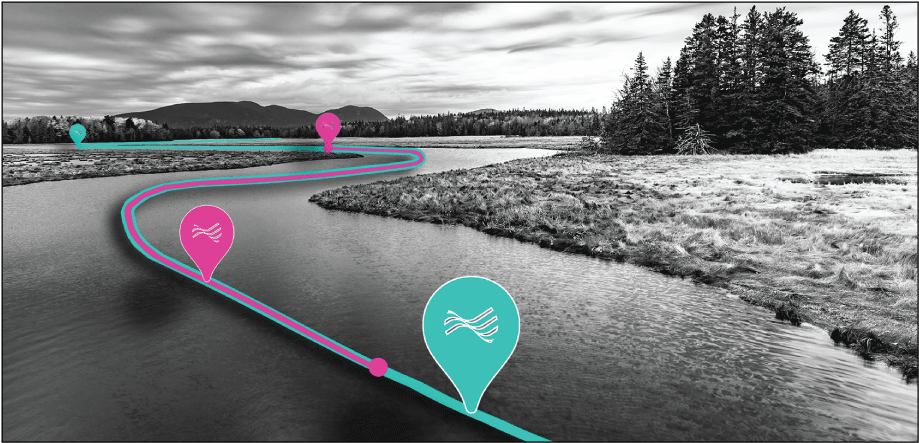
Conceptual graphic illustrating how observations about the Nation’s waters—water-quality information, fish occurrence, flow, bed material, and so on—can be attached to points along the stream network (as shown by the blue pins) or along lengths of the stream network (as shown by the magenta pins and line). Graphic by Alexander Jonesi, U.S. Geological Survey.
3DHP Lifecycle
Because of the large volumes of data to be acquired in the first several years, and the expectation that acquisitions would decline to a maintenance level later in the 3DHP, much of the work to delineate the stream network from elevation can be completed by the private sector for the USGS or partner organizations. The USGS will ensure that all acquired data meet published specifications (U.S. Geological Survey, 2022) regarding the derivation of hydrography features from 1-meter digital elevation models (DEMs) derived from light detection and ranging (lidar) data for the conterminous United States and Hawaii and 5-meter DEMs derived from interferometric synthetic aperture radar (IfSAR) data for Alaska. The USGS will be responsible for data validation prior to accepting data into national data holdings. Once in national data holdings, individual errors within the 3DHP datasets discovered by the USGS or reported by users can be corrected by USGS data editors; a 3DHP maintenance goal will be to correct errors 1–2 months after they are reported. The stream network is planned to be reviewed on a regional basis every 4–5 years, and regional updates are planned to be applied as needed. In the future, change detection based on either the elevation data or hydrography may trigger updates to 3DHP data.
The USGS will also be responsible for producing data related to the stream network, such as hydrologic units and some attributes, as well as the general management and delivery of data to the public. The planned datasets include hydrologic features such as those described in box 2. The USGS will maintain an enterprise system to manage the 3DHP datasets and infostructure. The 3DHP infostructure will be developed, tested, and operationalized to use the 3DHP datasets as the geospatial foundation.
Box 2. Core Hydrologic Features To Be Included in 3DHP Datasets
The 3D Hydrography Program (3DHP) datasets, when the 3DHP is fully implemented, are planned to include a core set of hydrologic features. These planned features include the following:
-
• Stream network—The stream network will be derived from two types of digital elevation models (DEMs): (1) for the conterminous United States and Hawaii, the 3D Elevation Program (3DEP) data will be from 1-meter standard product DEMs derived from light detection and ranging (lidar) data, and (2) for Alaska, the data will be from 5-meter DEMs derived from interferometric synthetic aperture radar (IfSAR) data. The data will include elevation values on each vertex to enable 3D analysis of the data.
-
• Hydrologically enhanced elevation and other surfaces—Hydrologically enhanced raster DEMs will be created as a part of the stream network derivation process so that the flow of water across the surface is represented accurately. Additional derivative surfaces may be developed and provided as products as the program matures.
-
• Topobathymetry—The U.S. Geological Survey (USGS) is researching how to create a continuous topobathymetric surface derived from high-resolution elevation and bathymetry. Plans to advance inland bathymetry towards a more systematic national approach can be addressed in the next generation of 3DEP.
-
• Hydrologic units—Hydrologic units will be derived by using the stream network and elevation data, while retaining and using important outlet point information from the Watershed Boundary Dataset.
-
• Groundwater connections—Connections between surface-water and groundwater features will be supported; for example, by identifying gaining and losing stream reaches or providing estimates of groundwater contributions to streamflow, where known.
-
• Wetlands—Collaborative mapping of the stream network and the National Wetlands Inventory (NWI) will enable the two datasets to function together as a whole and to accurately depict the inland waters of the United States.
-
• Engineered hydrologic systems—The 3DHP will include information on engineered hydrologic systems, with a concerted effort to integrate connection points to, or generalized representations of, stormwater systems in urban areas.
-
• Culverts—Culvert data acquired during the process of deriving hydrography from elevation data will be made available.
-
• Addressed data—The 3DHP will support a hydrographic addressing system such that data produced by users can be assigned a unique location on the network (similar to a street address) and shared across the user community (fig. 3).
Designing the Program
Program Scenarios
The HRBS highlighted the need for a modernized, 3D-enabled hydrography program to support emergent user and stakeholder applications. To help define a modernized program, three scenarios created from the HRBS were considered. Each scenario included the cost of developing the source data, the time required to build the national dataset, and the potential benefits enabled by the data produced as documented in the HRBS. The National Geospatial Program (NGP) consulted extensively with stakeholders and users of hydrography data through both public presentations and smaller venues to gather feedback on the potential program directions.
Scenario 1 (status quo) continues management of the current hydrography data with minimal incremental improvements. While the USGS would make general progress to update the NHD by using current technologies, continued local maintenance programs with a variety of funding sources and priorities would continue to decrease national consistency of the datasets over time.
Scenario 2 replaces all existing hydrography over a 9-year period with data derived from 3DEP-quality lidar data for the conterminous United States and Hawaii or IfSAR-derived data for Alaska. This scenario includes improvements supported by the HRBS, such as improved accuracy, accounting for more components of the hydrologic cycle, and more effective maintenance of data.
Scenario 3 is similar to Scenario 2, except the source data would be 0.5-meter DEMs created from Quality Level 1 (QL1) or better 3DEP lidar data. For a description of topographic data quality levels, please refer to https://www.usgs.gov/3d-elevation-program/topographic-data-quality-levels-qls. Scenario 3 meets more user requirements and provides more benefits, but at a substantially greater cost than Scenario 2. Currently, QL1 data are not readily available across the country, making this scenario difficult to achieve, but it may be a viable program in the future.
The USGS vision for the 3DHP is based on Scenario 2. A comparison of the three implementation scenarios (fig. 4) shows that the new benefits compared with program costs provide the greatest value in Scenario 2. This scenario would meet most mission-critical activity needs identified in the HRBS and has the potential to achieve more than $1.047 billion in annual benefits.
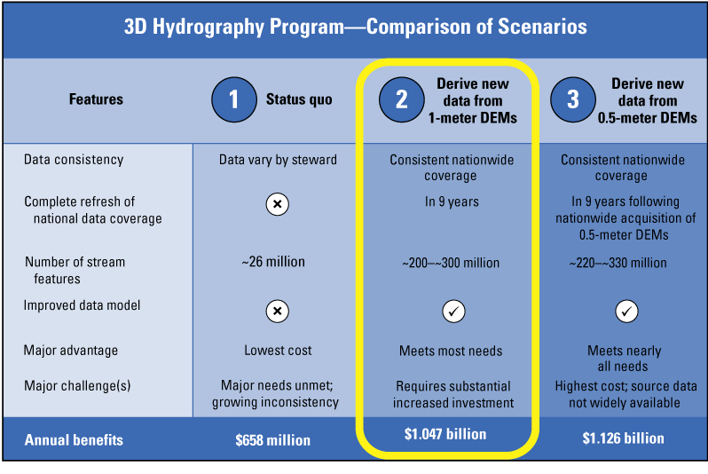
Chart comparing three scenarios for the 3D Hydrography Program (3DHP). The U.S. Geological Survey’s vision for the 3DHP is based on Scenario 2, which is outlined in yellow in the chart. The scenarios were based on data in Dewberry (2016). DEMs, digital elevation models. Symbols: x, feature is not included; ✓, feature is included.
3DHP Potential Community-Wide 9-Year Costs
The 3DHP program of work projects that the 9-year effort will begin in fiscal year 2024 (FY 2024), will have moderate growth for FY 2025, and will grow primarily through partnerships in subsequent years. Investments by Federal, State, Tribal, Territorial, and local government entities and private partners in lidar and IfSAR data collections through 3DEP have made it possible to derive 3DHP features from elevation data for a substantial portion of the Nation. For the proposed operational program to be fully realized, a similar community-wide investment of $685 million ideally would occur within the first 9 years; the timeframe includes 1 year of preparation, 6 years of delineating hydrography data from 3DEP elevation data, and 2 additional years to complete data validation, processing, and publication after the acquisition period. The length of the 9-year timeline may change, depending on available funding.
Just as 3DEP was successful in building community partnerships with government agencies and private organizations to fund data acquisition, the 3DHP plans to follow a similar collaborative funding model that would benefit from investments by partner organizations for shared data acquisition costs. For example, approximately 62 percent of the total funding that has come to 3DEP has been from partnerships (please refer to https://usgs.gov/3DEP/numbers for more information).
Data maintenance and distribution costs, as well as data contracting, validation, and processing expenses would be included in the core USGS budget for the 3DHP. The cost-sharing model (fig. 5) is one potential model and is not intended to allocate cost shares to any organization or to individual government sectors. The actual funding model is expected to evolve and change in the program operations plan.
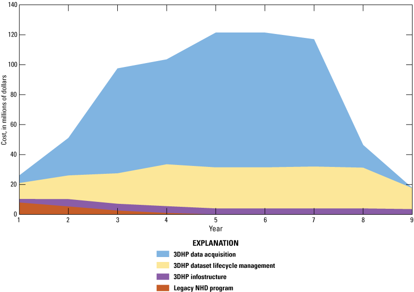
Graph showing the proposed community-wide 9-year costs broken out by category for implementation of the 3D Hydrography Program (3DHP). The highest costs are projected for 3DHP data acquisition and 3DHP dataset lifecycle management; much smaller costs are projected for the 3DHP infostructure and for the legacy NHD program. NHD, National Hydrography Dataset.
Building the Program
Leadership and Governance
Governance of the 3DHP will be led by senior executives from cooperating agencies through the 3D Elevation Federal Interagency Coordinating Committee (FICC) that is being established by the U.S. Department of the Interior as required by the National Landslide Preparedness Act (Public Law 116–323). The committee will oversee the formulation and approval of policies and priorities recommended by the 3DEP and 3DHP Working Groups. The National Hydrography Infrastructure (NHI) Working Group, created in 2018 as a forum for Federal agencies, has transitioned to become the 3DHP Working Group (3DHP WG). The 3DHP WG will provide input and collaboration on the development of the 3DHP datasets and infostructure and will take on new responsibilities for prioritizing and coordinating data acquisition. The structure and next steps for the FICC are being determined by the U.S. Department of the Interior’s Assistant Secretary for Water and Science.
Partnering To Acquire Data
To be successful, the 3DHP can build on existing relationships to establish a systematic and unified process for data acquisition partnerships. The 3DHP intends to use a partnership-based acquisition model, in alignment with the one used for 3DEP data acquisition (fig. 6). When USGS funding is available, partners will be able to propose acquisition projects that use the USGS Geospatial Products and Services Contracts (GPSC) or their own contracts to acquire data that meet the 3DHP specifications. Organizations may also contribute data that meet 3DHP specifications and that were acquired independently; the USGS will implement a standard procedure for reviewing those datasets for inclusion in the 3DHP.
The USGS will facilitate the sharing of partner mapping requirements to help identify common areas of interest and leverage funds. The strategy would help prioritize acquisitions where there are multiple requirements and a high potential for leveraging funds. Data acquisition is planned to take place by whole hydrologic units, with an emphasis on collection through multipartner and multistate funding coalitions.
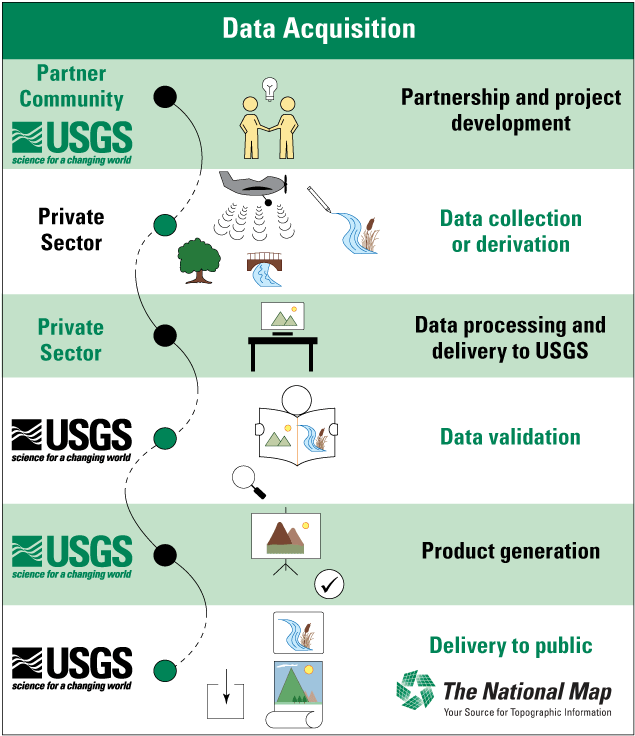
Chart showing phases of data acquisition, processing, and delivery to partners and the public for the 3D Hydrography Program (3DHP). The phases are similar to those used for the 3D Elevation Program (3DEP). USGS, U.S. Geological Survey.
Collaborating To Build the Internet of Water
Community collaboration and cooperation are core components of the 3DHP, the 3DHP infostructure, and the Internet of Water. While the USGS and partner agencies will provide the overarching structure and functionality of the 3DHP infostructure, the data searchable through it will be managed by the datasets’ authoritative producers. This federated structure gives data producers control over their information while sharing it with the broader community. In turn, the community of users can efficiently search and access the most authoritative data.
Outreach and Communications
Outreach will be an important aspect of the program because the success of the 3DHP is dependent on a broad base of support and participation from Federal agencies, State and Tribal governments, and other stakeholders. Outreach will continue to be directed toward growing a user base for 3DHP products and toward gathering feedback to ensure that the 3DHP is responsive to the needs of government and private sector users. Equally important is a focus on building support and a community-wide funding base to move the program forward.
Roles and Responsibilities
The whole water-resources community has a role to play in the 3DHP, from partnerships, to data development, to creating new and unimagined applications (fig. 7). Today, States are major contributors of data and often lead statewide acquisition and maintenance programs through stewardship agreements with the USGS. The 3DHP will not include a formalized stewardship program. Rather, the 3DHP will focus on cooperative community data acquisition and on building and responding to a network of users with local knowledge who improve 3DHP data by reporting errors. Iterative improvements to the 3DHP datasets to support local needs and requirements will be identified jointly, and the 3DHP infostructure will be developed to empower users to manage their water-related data to promote sharing and new and emerging applications.
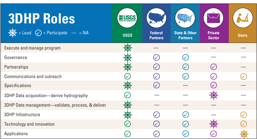
Chart showing the roles to be played by the U.S. Geological Survey (USGS); Federal partners; State, Tribal, and local partners; the private sector; and users in the 3D Hydrography Program (3DHP). Roles include managing the program, acquiring and validating data, and delivering products to partners and the public. NA, not applicable.
Next Steps
As proposed, the 3DHP effort would begin providing products and services to partners and the public in 2024. The strategy is to leverage funding from partners and to encourage increased contributions from all sources. Because 3DHP depends on private sector mapping firms to collect data, jobs will be created as the funding increases. Additional jobs will result when the new applications are developed and implemented based on the 3DHP data, as documented in the HRBS (Dewberry, 2016). At the full funding level for Scenario 2, the 3DHP could return more than $1 billion annually in benefits directly to the private sector and indirectly to citizens through improved government program services (Dewberry, 2016).
Milestones
The project milestones shown in figure 8 represent major and time-sensitive accomplishments that can lead to the successful implementation of the 3DHP. The schedule is based on assumptions of successfully securing community-wide funding and additional assumptions of products and services as described in the figure. A critical transition occurred during 2023, when maintenance on the legacy datasets—NHD, WBD, and NHDPlus HR—was brought to a close, and data acquisition and production shifted to the 3DHP. Static versions of the legacy datasets have been published and continue to be available to support existing applications while 3DHP data are acquired, validated, and published.
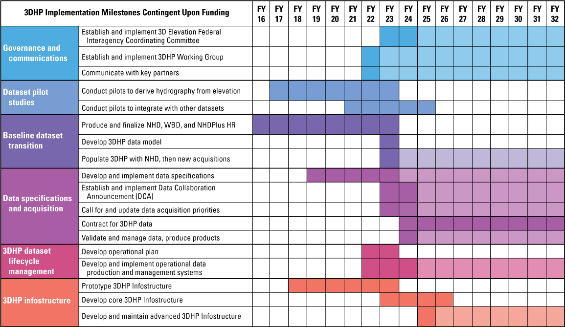
Chart showing the general schedule and implementation milestones for the 3D Hydrography Program (3DHP). Dark cells indicate initiation or active development on a task or activity, and lighter colors indicate continuation or ongoing maintenance of the task or activity. (Note: This chart assumes funding levels that have not been requested nor provided. This timeline may change depending on available funding.) Terms: FY, fiscal year; NHD, National Hydrography Dataset; NHDPlus HR, National Hydrography Dataset Plus High Resolution; WBD, Watershed Boundary Dataset.
Research Requirements
The 3DHP planning process identified numerous issues or questions for which additional assessments, evaluations, and research would be beneficial. A 3DNTM research plan that addresses both 3DHP and next generation 3DEP research needs is expected to be completed by the end of FY 2024. Operational development will be undertaken by the USGS National Geospatial Technical Operations Center. More fundamental geospatial and hydrological research will be carried out by the USGS Center of Excellence for Geospatial Information Science; the USGS Water Resources Mission Area, particularly the Integrated Modeling and Prediction Division; and the broader community of researchers and users. The near-term and immediate research requirements have been identified, and the research agenda will be managed as a cohesive activity by the USGS through the NGP. As the 3DHP develops to include additional functionality, such as incorporating linkages to surficial geology, research is planned to include an expanded set of organizations with appropriate subject matter expertise, such as the National Cooperative Geologic Mapping Program.
To address emerging needs and to test emerging technologies, the development strategy for the 3DHP infostructure calls for an iterative evolution of products and services. Development teams will advance a core functionality, and through feedback from the community, the 3DHP infostructure can be improved. User community input and collaboration will also be provided by the 3DHP Working Group. Over time, the 3DHP infostructure will evolve to improve functionality and grow additional partnerships through the community.
Conclusion
The implementation of the 3D Hydrography Program (3DHP) marks the beginning of a new era of water data. The public and private sectors that depend on high-quality water data have expressed through the results from the National Hydrography Requirements and Benefits Study (Dewberry, 2016) and other mechanisms the need for much better information to answer the most demanding questions about water-resource management, including more precise and accurate flood-inundation modeling, more detailed understanding of tributaries and urban systems, and better accounting of water availability for human and ecosystem use. The USGS proposes to work with partners to share the costs of a new program that will address these needs in approximately 9 years if the community funds are available to complete the work. Federal, State, Tribal, and local governments are making independent investments to improve their water information, and without a coordinated effort, their investments are not contributing to a consistent set of national water data. If government agencies respond to this Call for Action, then the community can implement the 3DHP datasets and infostructure as the national geospatial underpinnings for water information. The return on investment has the potential to be substantial. The datasets can help inform critical water-resources decisions. Together, the community members can help achieve the 3D Hydrography Program.
References Cited
Dewberry, 2016, National hydrography requirements and benefits study—Preliminary results, May 20, 2016: Fairfax, Va., Dewberry, 139 p. plus appendixes A–O, accessed January 28, 2022, at https://www.dewberry.com/services/geospatial/national-hydrography-requirements-and-benefits-study.
Federal Geographic Data Committee, 2021, FGDC technical guidance—Data.gov and The GeoPlatform metadata recommendations including guidelines for National Geospatial Data Assets (NGDA) (version of October 27, 2021): Federal Geographic Data Committee website, accessed January 28, 2022, at https://www.fgdc.gov/technical-guidance/metadata/fgdc-technical-guidance-datagov-geoplatform-ngda.pdf.
U.S. Department of the Interior, [2022], Budget justifications and performance information, fiscal year 2023—U.S. Geological Survey: U.S. Department of the Interior report, 180 p., accessed April 9, 2024, at https://d9-wret.s3.us-west-2.amazonaws.com/assets/palladium/production/s3fs-public/media/files/FY23-USGS-Greenbook.pdf.
U.S. Geological Survey, 2022, Hydrography standards and specifications: U.S. Geological Survey website, accessed January 28, 2022, at https://www.usgs.gov/ngp-standards-and-specifications/hydrography-standards-and-specifications.
Abbreviations
3D
three dimensional
3DEP
3D Elevation Program
3DHP
3D Hydrography Program
3DHP WG
3D Hydrography Program Working Group
3DNTM
3D National Topography Model
DEM
digital elevation model
DOI
Digital Object Identifier
FAIR
Findable, Accessible, Interoperable, and Reusable
FGDC
Federal Geographic Data Committee
FICC
3D Elevation Federal Interagency Coordinating Committee
FY
fiscal year
GPSC
Geospatial Products and Services Contracts (USGS)
HRBS
National Hydrography Requirements and Benefits Study
IfSAR
interferometric synthetic aperture radar
lidar
light detection and ranging
NGP
National Geospatial Program
NHD
National Hydrography Dataset
NHDPlus HR
National Hydrography Dataset Plus High Resolution
NHI
National Hydrography Infrastructure
NWI
National Wetlands Inventory (U.S. Fish and Wildlife Service)
QL1
Quality Level 1
USGS
U.S. Geological Survey
WBD
Watershed Boundary Dataset
For additional information, contact:
Director, National Geospatial Program
U.S. Geological Survey
Mail Stop 511
12201 Sunrise Valley Drive
Reston, VA 20192
Website: https://www.usgs.gov/programs/national-geospatial-program
Email: 3dhp@usgs.gov
Disclaimers
Any use of trade, firm, or product names is for descriptive purposes only and does not imply endorsement by the U.S. Government.
Although this information product, for the most part, is in the public domain, it also may contain copyrighted materials as noted in the text. Permission to reproduce copyrighted items must be secured from the copyright owner.
Suggested Citation
Anderson, R., Lukas, V., and Aichele, S.S., 2024, The 3D National Topography Model Call for Action—Part 1. The 3D Hydrography Program (ver. 1.1, July 2024): U.S. Geological Survey Circular 1519, 12 p., https://doi.org/10.3133/cir1519.
ISSN: 2330-5703 (online)
ISSN: 1067-084X (print)
| Publication type | Report |
|---|---|
| Publication Subtype | USGS Numbered Series |
| Title | The 3D National Topography Model Call for Action—Part 1. The 3D Hydrography Program |
| Series title | Circular |
| Series number | 1519 |
| ISBN | 978-1-4113-4579-9 |
| DOI | 10.3133/cir1519 |
| Edition | Version 1.0: June 6, 2024; Version 1.1: July 1, 2024 |
| Publication Date | June 06, 2024 |
| Year Published | 2024 |
| Language | English |
| Publisher | U.S. Geological Survey |
| Publisher location | Reston, VA |
| Contributing office(s) | National Geospatial Program |
| Description | iv, 12 p. |
| Online Only (Y/N) | N |
| Additional Online Files (Y/N) | N |