

Plan To Coordinate Post-Earthquake Investigations Supported by the National Earthquake Hazards Reduction Program (NEHRP)
Links
- Document: Report (6.02 MB pdf) , HTML , XML
- Superseded Publications:
- Download citation as: RIS | Dublin Core
Acknowledgments
In 2021, the Applied Technology Council (ATC), with funding from the U.S. Geological Survey (USGS) under contract 140G0121P0309, commenced the ATC-155 Project, “Development of an Updated Plan to Coordinate NEHRP Post-Earthquake Investigations, Phase II.” The purpose of the project was to prepare a second-generation plan with new information to replace USGS Circular 1242, “The Plan to Coordinate NEHRP Post-Earthquake Investigations,” which was published in 2003. ATC is indebted to the leadership of Chris Poland, Project Technical Director, and to the other members of the Project Technical Committee, including Jonathan D. Bray, Laurie Johnson, Sissy Nikolaou, Ellen Rathje, and Brian Sherrod, who prepared this report. The Project Review Panel consisted of Diego Arcas, Luciana Astiz, Tanya Brown-Giammanco, David Green, Abraham Gunn, Thomas Holzer, Katherine Johnson, Keith Knudsen, Gari Mayberry, Jacqueline R. Meszaros, Khalid Mosalam, Michael Oskin, Lori Peek, Andrea Ruminski, Pataya Scott, Vasily Titov, and Heidi Tremayne; the panel provided technical reviews and advice at key stages of the work. ATC also gratefully acknowledges Michael Blanpied and Jonathan Godt (both of the USGS) for their input, review, and guidance, and Ginevra Rojahn and Kiran Khan (both of ATC) for report production services. The names and affiliations of all who contributed to this report, including those who participated in the review workshop on June 1, 2022, are provided in the list of project participants in appendix A.
1.0. Introduction
1.1. Purpose
This report presents a plan supported by the National Earthquake Hazards Reduction Program (NEHRP) to coordinate domestic and international post-earthquake investigations (herein called “the Plan”). The Plan describes the activation and coordination of the four designated NEHRP Agencies in the Federal Government:
-
• Federal Emergency Management Agency (FEMA; https://www.fema.gov/) of the U.S. Department of Homeland Security,
-
• National Institute of Standards and Technology (NIST; https://www.nist.gov/) of the U.S. Department of Commerce (NIST is the lead NEHRP Agency),
-
• U.S. National Science Foundation (NSF; https://www.nsf.gov/), and
-
• U.S. Geological Survey (USGS; https://www.usgs.gov/) of the U.S. Department of the Interior.
The Plan also describes coordination between NEHRP Agencies and other organizations that participate in pre-event and post-earthquake investigations. They may include non-NEHRP Federal agencies; State, regional, local, Tribal, and territorial agencies; domestic nongovernmental organizations; academic institutions and affiliated organizations; private companies; foreign governmental agencies and nongovernmental organizations; and international organizations.
NEHRP is the Federal Government’s coordinated nationwide program to reduce risks to life and property in the United States, U.S. territories, and federally recognized Tribal Nations (all herein included in the “United States”) that result from earthquakes. The Earthquake Hazards Reduction Act of 1977 (Public Law 95–124), as amended by the National Earthquake Hazards Reduction Program Reauthorization Act of 2018 (Public Law 115–307) (herein called “the Act”), authorizes the investigation of significant domestic and international earthquakes to learn lessons that can be applied to reduce future earthquake losses in the United States. The Act states that the investigations shall begin as rapidly as possible and results shall be disseminated widely.
The Act also specifically directs the USGS to organize post-earthquake investigations to study the implications of earthquakes in the responsibility areas of each of the four NEHRP Agencies and to utilize expertise of other Federal agencies and private contractors. Thus, the USGS is the lead NEHRP Agency for activating and coordinating NEHRP post-earthquake investigations and for implementing this Plan. The Plan does not preclude any of the four NEHRP Agencies from studying the implications of earthquakes, domestic or international, within the areas of their own responsibilities and outside the scope of this Plan.
In addition to delineating the coordination of NEHRP post-earthquake investigations, the Plan identifies pre-event activities necessary to ensure that post-earthquake investigations are executed effectively. The USGS also leads coordination of the NEHRP Agencies in completing the pre-event activities identified in the Plan.
The Plan should be viewed as guidance for pre-event and post-earthquake activities to be undertaken by NEHRP Agencies depending upon their available resources and priorities.
Additional background information, a description of the development process for the Plan, and a list of project participants are contained in appendix A. The responsibilities of the NEHRP Agencies as enumerated by the Act are presented in appendix B.
1.2. Achieving an Earthquake-Resilient Nation
The United States must be ready and capable to withstand, respond to, and recover from earthquakes and their consequences. The strategic goals and objectives in the NEHRP Strategic Plan (NIST, 2023) describe how the United States enhances its resilience and security against earthquake effects by developing, advancing, and disseminating knowledge, tools, practices, and policies.
Post-earthquake investigations should be coordinated to maximize learning and to translate lessons quickly and effectively into practices that mitigate the effects of future earthquakes. Experience has demonstrated that post-earthquake investigations can substantially further the achievement of the following goals:
-
• Improved societal preparedness,
-
• Enhanced emergency response and recovery,
-
• Better characterization of earthquake hazards,
-
• A safer and more resilient built environment, including improved land-use practices that support community resilience, and
-
• More cost-effective construction of new structures and rehabilitation of older ones.
Achieving a more resilient Nation demands that we understand what happens to the built environment and to society when an impactful earthquake occurs. Documenting and sharing the key lessons learned from earthquakes worldwide contribute significantly to advancing the understanding of earthquake processes and their effects. Earthquakes provide critical information, and many engineering design procedures and community response plans are based on insights gleaned from the observations of past events. Field observations are particularly important because it is difficult to replicate in the laboratory geologic features built by nature over millions of years; interdependencies of large-scale infrastructure systems; the seismic performance of large inventories of buildings; the impacts of cascading, compounding, and co-occurring events, such as tsunamis, landslides, or fire-following earthquake; and the behavior of people confronted by death and destruction.
Coordination of multidisciplinary and interdisciplinary research efforts following earthquakes can enhance the information acquired and its dissemination. The nature and quality of this information can significantly reduce losses from future events through improved planning, design, and construction. Because many of the data generated by earthquakes are perishable, organizations should be prepared to respond in a timely and sustained manner to collect observational data describing what happens when earthquakes strike.
Domestic earthquakes provide the best opportunity to evaluate seismic hazards, the performance of the built environment, and the effects on the socioeconomic environment in the United States, where lessons learned can be implemented directly. International earthquakes can also provide valuable learning opportunities. They often affect geologic environments similar to those in the United States, which can provide knowledge to advance U.S. geoscience and geotechnical engineering. Because building codes and practices in some countries are similar to U.S. codes and practices, insights on building and lifeline performance in international earthquakes can directly inform future U.S. codes and practices. And insights gleaned from social science research abroad are often relevant to the United States.
However, conducting investigations in foreign countries often presents challenges that are not present for domestic investigations. For example, investigations in foreign countries greatly benefit from, perhaps even require, collaboration with local agencies to be effective; proficiency in languages other than English may be necessary; and travel can be more restricted than it is in the United States. Consequently, the Plan has descriptions of different responses to domestic earthquakes and international earthquakes.
2.0. Plan Organization, Maintenance, and Exercises
2.1. Plan Structure and Phases
The main purpose of the Plan is to facilitate the activation and coordination of NEHRP post-earthquake investigations. The decision to undertake a NEHRP post-earthquake investigation is primarily based on whether an earthquake presents an important opportunity to learn lessons that can reduce the loss of lives and property in future earthquakes. Thus, the specific criteria for activation considered by the NEHRP Agencies are likely to evolve over time and will be informed by critical gaps in research and practice that are needed to achieve seismic resilience. NEHRP Agencies should retain flexibility to activate post-earthquake investigations when important opportunities that may not have been previously identified arise following an earthquake.
This Plan describes the response for various levels of earthquake impacts, both domestic and international, indicates which actions are part of the coordinated response of NEHRP Agencies, and designates actions that may be taken for international earthquakes. More details on the criteria for activating implementation of the Plan following an earthquake are provided in section 3.0. Individual NEHRP Agencies may also study the implications of earthquakes within the areas of their own responsibilities and outside the scope of this Plan.
The Plan has post-earthquake investigations organized into three phases:
-
• Phase 1: Plan Activation (Minutes to Days)
-
• Phase 2: Perishable Data Reconnaissance (Days to Months)
-
• Phase 3: Research and Knowledge Transfer (Months to Years)
The event-specific activities related to each phase are provided in sections 4.0 through 6.0. A flow chart of the phases and key activities addressed in the Plan is shown in figure 1.
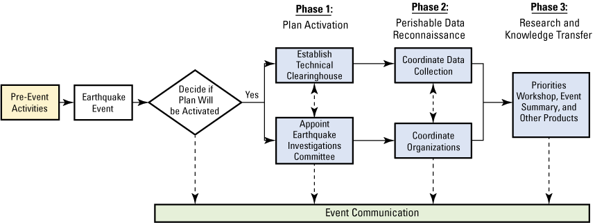
Flow chart showing phases and key activities addressed in the plan presented in this report that are related to post-earthquake investigations supported by the National Earthquake Hazards Reduction Program (NEHRP).
2.2. Key Participants in the Plan
The work of NEHRP is coordinated at the highest level by the Interagency Coordinating Committee (ICC) on Earthquake Hazards Reduction and at the working level by the Program Coordination Working Group (PCWG). The ICC is chaired by the NIST Director and includes the Administrator of FEMA and the Directors of the U.S. National Science Foundation, the Office of Management and Budget, the Office of Science and Technology Policy, and the U.S. Geological Survey. The PCWG has designated representatives from each of the NEHRP Agencies who meet regularly to report on individual Agency activities and coordinate program efforts, including budget reporting and strategic planning.
The USGS, acting through its Earthquake Hazards Program (EHP) is the lead Agency for activating and coordinating NEHRP post-earthquake investigations and calls upon the PCWG to help the USGS fulfill its responsibilities as Investigation Coordinator under the law and to lead pre-event and post-earthquake coordination activities on behalf of NEHRP as specified in the Plan. The PCWG can be a nexus through which NEHRP coordination is managed.
Following an earthquake, the PCWG may appoint an ad hoc Earthquake Investigations Committee (EIC) to carry out the day-to-day coordination, or the PCWG may choose to serve in this capacity itself; to include these options, the PCWG-EIC is designated in the Plan as the main coordinating body. The PCWG-EIC should include at least one representative from each of the NEHRP Agencies. The representative from the USGS will serve as the committee chair and lead the investigations coordination. The PCWG-EIC is discussed further in section 4.0.
For pre-event and post-earthquake investigations to be effective, the NEHRP Agencies may coordinate with other organizations, as described in the Plan. As mentioned in section 1.1, other potential partners include non-NEHRP Federal agencies; State, regional, local, Tribal, and territorial agencies; domestic nongovernmental organizations; academic institutions and affiliated organizations; private companies; foreign governmental agencies and nongovernmental organizations; and international organizations (fig. 2). Potential partnering organizations should evolve over time and be informed by advances in technology, programs, and policy, as well as by research and practice on achieving seismic resilience. Additional information about potential partnering organizations is presented in appendix C and appendix D.
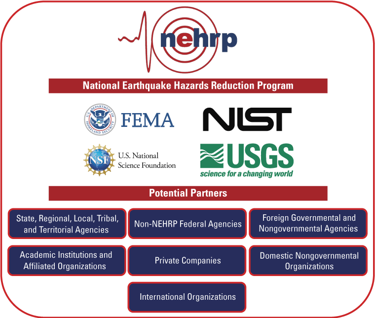
Diagram showing categories of potential domestic and foreign partnering organizations for pre-event and post-earthquake investigations supported by the National Earthquake Hazards Reduction Program (NEHRP). The four NEHRP Agencies are the Federal Emergency Management Agency (FEMA), the National Institute of Standards and Technology (NIST), the U.S. National Science Foundation (NSF), and the U.S. Geological Survey (USGS).
2.3. Pre-Event Activities
Advance planning helps ensure that the Plan and potential partners are ready for post-earthquake activation. The following pre-event activities are recommended for the PCWG for both domestic and international earthquakes.
-
1. Maintain a contact catalog of potential partnering organizations opting in to receive notifications and schedules of NEHRP post-earthquake investigation coordination calls. Widely announce the opportunity to be included in coordination calls and provide a means for organizations to easily update their contact information.
-
2. Maintain a database of regional and State earthquake Technical Clearinghouse plans that are submitted for inclusion, as well as key contacts for the plans. Ask State geologists to enroll their Technical Clearinghouse plans in the database. Develop a process for quickly launching and managing a Technical Clearinghouse in States and territories where such capabilities do not exist.
-
3. Develop the content template and protocols for posting key information about NEHRP response activities on the USGS event page, or another suitable public-facing website determined by the PCWG, for the purpose of broadly communicating NEHRP post-earthquake investigations information. This site is referred to as the event page in the Plan (please refer to section 3.1).
-
4. Provide links to existing guidelines for ethical and safety considerations for conducting post-earthquake investigations, and encourage training.
-
5. Develop a process to engage with foreign countries and international organizations for NEHRP-sponsored post-earthquake investigations in foreign countries where lessons can be learned. This process should include clarifying when U.S. State Department approval is necessary.
-
6. Develop a process for engaging with international investigators in declared NEHRP investigations of domestic earthquakes.
-
7. Seek to identify funding and staffing for Plan operations, where possible.
In addition, the USGS, with support from the PCWG, should work to ensure that the activation, coordination, and overall objectives of NEHRP post-earthquake investigations help to facilitate disaster response and recovery operations. These objectives should align with the “National Response Framework” (NRF) from FEMA (2019b) and the “National Disaster Recovery Framework” (NDRF), also from FEMA (2016). Both frameworks define the Federal role in response to all types of disasters and emergencies and in enabling effective recovery support to disaster-impacted States and local, Tribal, and territorial jurisdictions. Appendix E provides additional information on both frameworks.
2.4. Testing and Exercising the Plan
As part of its coordination role, the USGS, with support from the PCWG, should develop and conduct exercises and training sessions on the Plan to test it against realistic earthquake scenarios and promote Plan awareness, working knowledge, and coordination among NEHRP Agencies, potential partners, and other stakeholders. Exercises and training sessions may vary in style and levels of participation, be held remotely or in person, and include the following:
-
• Walk-throughs, workshops, sessions at regularly scheduled earthquake conferences, or orientation seminars,
-
• Tabletop exercises,
-
• Functional exercises to role play specific features of the plan,
-
• Full-scale exercises, perhaps as part of larger, regional earthquake response exercises, and
-
• Unannounced or no-notice exercises.
An exercise should be conducted within 1 year of completion of the Plan and at least once every 3 years thereafter, or as needed to ensure that PCWG representatives are prepared to launch and support post-earthquake investigations whenever needed. Organizers choosing dates and locations for exercises may consider timing and coordination opportunities with NEHRP Agencies, professional association meetings, and earthquake-response exercises hosted by Federal, State, and local emergency management agencies and regional earthquake consortia.
Realistic earthquake scenarios should vary in earthquake intensity, geographic coverage across different regions of the United States, stakeholders engaged, and scale and consequences of earthquake impacts and data-gathering needs; scenarios may include compounding and cascading earthquake disasters involving other natural and technological hazards, and co-occurrences of tsunamis, fire-following earthquake, and other events. These exercises and their results can be recorded as playbooks to be referenced by the PCWG and key agencies when actual earthquakes with similar characteristics occur.
Exercises and training will include training on safety and the ethical procedures and protocols of post-earthquake investigations and other activities defined by the Plan. Exercise and training evaluations should assess (1) if actions identified in the Plan were effectively implemented during the exercise, (2) if the contents of the Plan need revision, and (3) if the engagement and performance of all participants led to positive results.
Finally, ensuring Plan readiness means that there should be live, online access for relevant parties to the Plan document at all times, with any amendments also available as they occur. The USGS and other NEHRP Agencies should be mindful of staffing changes and the need to familiarize new representatives with Agency responsibilities under the Plan.
2.5. Reviewing and Updating the Plan
Given the relative infrequency of damaging earthquakes in the United States, it is important that the Plan be reviewed regularly. The PCWG leads the process of reviewing and amending the plan, as needed:
-
• When there are new or changed laws related to NEHRP that affect the Plan,
-
• When the Plan is activated for a Level 1 domestic earthquake (section 3.1), or
-
• When technology advancements are relevant to aspects of the Plan.
All NEHRP Agencies, key partners, and a broad array of stakeholders should be involved in the review, including members of the professional and research communities.
3.0. Guidelines for Activating Post-Earthquake Investigations
Guidance for characterizing earthquake events and activating NEHRP post-earthquake investigations is presented in this section.
3.1. Descriptions of Earthquakes in the Plan
Information on the impact of an earthquake is obtained from sources listed below:
-
• The USGS Prompt Assessment of Global Earthquakes for Response (PAGER) system uses an Earthquake Impact Scale (EIS) to provide summary alert levels (herein called “PAGER alerts”). PAGER is the primary tool envisioned in the Plan for categorizing the potential impact of an earthquake. PAGER is described at https://earthquake.usgs.gov/data/pager/. PAGER provides estimated fatality and economic-loss alert levels (green, yellow, orange, red) following significant earthquakes. The higher of the fatality and economic-loss alert levels is the EIS summary alert level for an event. Part of the orange PAGER alert for the 2018 Anchorage, Alaska, earthquake is shown in figure 3 as an example of its information. Some USGS products for the Anchorage earthquake use the alternate name, Point MacKenzie earthquake (fig. 4), but the Anchorage name is more commonly used.
-
• The information from a PAGER alert should be complemented with information from other reputable sources, including the following:
-
o USGS Earthquake Hazards Program event page for the earthquake, which includes the PAGER alert, among other data and products, and which can be found via the USGS EHP website at https://www.usgs.gov/programs/earthquake-hazards/earthquakes. An example of an event page is shown in figure 4.
-
o National Oceanic and Atmospheric Administration (NOAA) U.S. Tsunami Warning System website, which shows alert levels at https://tsunami.gov/.
-
o FEMA’s Geospatial Resource Center, which links to earthquake advisories from https://gis-fema.hub.arcgis.com/.
-
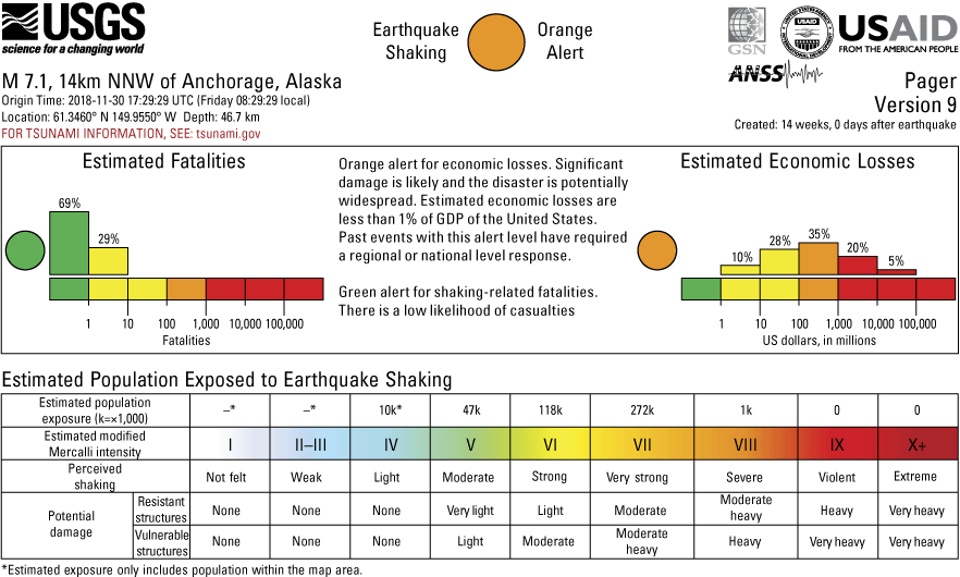
Screenshot of part of a PAGER alert for the 2018 Anchorage, Alaska, earthquake (from https://earthquake.usgs.gov/product/losspager/ak20419010/us/1552072494530/onepager.pdf; accessed June 21, 2024). Terms: ANSS, Advanced National Seismic System; GDP, gross domestic product; GSN, Global Seismographic Network; km, kilometer; M, magnitude; N, north; NNW, north-northwest; PAGER, Prompt Assessment of Global Earthquakes for Response; USAID, U.S. Agency for International Development; USD, U.S. dollar; UTC, coordinated universal time; W, west.
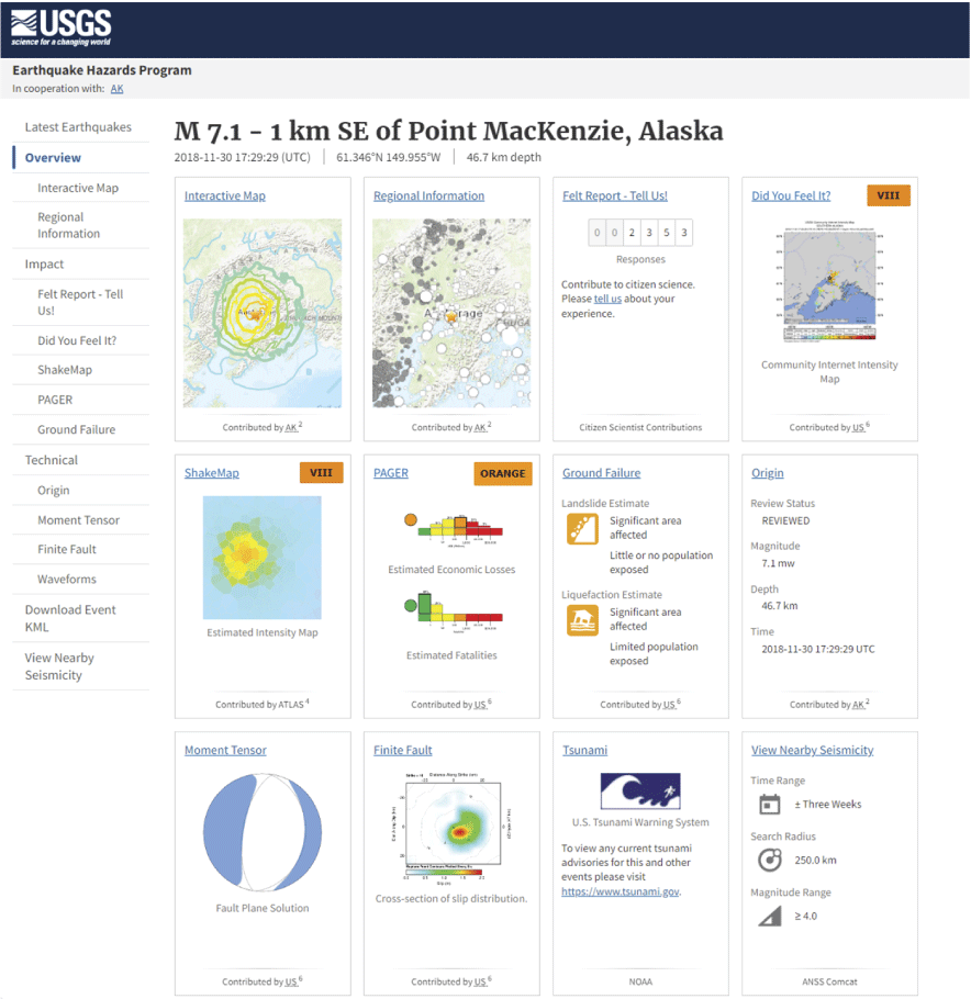
Screenshot of part of the U.S. Geological Survey (USGS) Earthquake Hazards Program event page for the 2018 Anchorage, Alaska, earthquake (from https://earthquake.usgs.gov/earthquakes/eventpage/ak20419010/executive; accessed June 21, 2024). The USGS provided the event page for the 2018 Anchorage earthquake under the alternate name, Point MacKenzie earthquake. Event pages provide information about a recent or previously recorded earthquake. Each rectangle, or “card,” is a link to a situational awareness product or web page with further information. The USGS creates an event page for each earthquake as soon as it is detected; information and cards are added or updated as additional data are gathered and analyses performed.
Earthquake levels for the Plan are assigned on the basis of initial data. The NEHRP Agencies may adjust the level of an earthquake after considering information in addition to that provided by PAGER or the other sources listed above. Levels are defined below:
-
• A significant earthquake is an event considered by NEHRP Agencies to provide an opportunity to learn how to reduce future earthquake losses in the United States. It presents an important opportunity to address high-priority critical gaps in knowledge. The determination of whether an earthquake is significant is made through consideration of the goals of the NEHRP Strategic Plan (NIST, 2023). NEHRP Agencies should retain flexibility to identify important opportunities that may not have been identified before an earthquake occurs to ensure that an event that produces important information is investigated.
-
• A significant domestic earthquake occurs within the United States or is an international earthquake that causes damage in the United States. It is categorized in one of three potential impact levels:
-
o Level 1: A significant domestic earthquake is categorized as Level 1 if it has a red or orange PAGER alert. Level 1 is also used for an international earthquake that causes significant damage in the United States, including damage from a tsunami (designated a WARNING alert level on the NOAA Tsunami Warning System website). NEHRP Agencies should also consider categorizing an earthquake as Level 1 if a Federal disaster activation has been made or is likely to be made, especially if a Presidential disaster declaration is likely.
-
o Level 2: A significant domestic earthquake is categorized as Level 2 if it has a yellow PAGER alert. Level 2 is also used for an international earthquake that causes moderate damage in the United States, including damage from a tsunami.
-
o Level 3: A significant domestic earthquake is categorized as Level 3 if it has a green PAGER alert. Level 3 is also used for an international earthquake that causes minor damage in the United States, including damage from a tsunami. Such an earthquake may be categorized as Level 3 if the NEHRP Agencies judge that it could provide an opportunity to address high-priority critical gaps in knowledge.
-
-
• A significant international earthquake is an international earthquake that does not cause damage in the United States but provides an important opportunity to learn how to reduce future U.S. earthquake losses. In assessing an international earthquake, the NEHRP Agencies should also consider the PAGER alert level, security issues, politics, the availability of local partnering agencies, whether U.S. agencies are invited to participate by foreign governments, and if key lessons can be learned from in-country organizations without implementing the Plan. It is categorized in one of two levels:
-
o Level A: A significant international earthquake is categorized as Level A if a comprehensive, multidisciplinary post-earthquake investigation is appropriate.
-
o Level B: A significant international earthquake is categorized as Level B if a limited, focused post-earthquake investigation is appropriate.
-
3.2. Earthquake Notification and Plan Activation
Upon receiving notification of a potentially significant earthquake event regardless of location, the PCWG should consider whether a NEHRP post-earthquake investigation may be appropriate through the following actions:
-
1. All domestic earthquakes with a yellow PAGER alert or higher that are automatically announced by the National Earthquake Information Center (NEIC) Earthquake Notification Service (ENS) or an international earthquake that produces a tsunami with moderate damage in the United States should include an alert to the PCWG that the USGS will initiate a coordination call within 24 hours. All international earthquakes with an orange PAGER alert or higher that are automatically announced by NEIC through the ENS should be considered for initiation of an email discussion within 48 hours by the USGS with the PCWG, which may lead to a coordination call. A domestic earthquake with a green PAGER alert may initiate a coordination call if one or more NEHRP Agencies identifies the earthquake as being significant due to the opportunities it presents to address high-priority critical gaps in knowledge.
-
2. The USGS should convene the initial PCWG coordination call to complete these tasks:
-
a. To review the available event page, other relevant data sources provided in section 3.1, and the opportunities to advance the goals of the NEHRP Strategic Plan (NIST, 2023).
-
b. To initially categorize the event as a Level 1, 2, or 3 significant domestic earthquake, as a Level A or B significant international earthquake, or as an event that is not a significant earthquake using the guidance in section 3.1. Each NEHRP Agency should share their assessment of the significance of the earthquake and their thoughts on what they might do.
-
c. To decide whether to activate a NEHRP post-earthquake investigation. If the PCWG decides to activate a NEHRP post-earthquake investigation, the specific scope and timing of the post-earthquake investigation will be determined in Phase 1 of the Plan (section 4.0) considering the final categorization of the event. If the decision is not to activate a NEHRP investigation, individual NEHRP Agencies or other organizations may decide to perform post-earthquake investigations, but these activities will not be considered a NEHRP post-earthquake investigation.
-
4.0. Phase 1: Plan Activation (Minutes to Days)
The successful coordination of post-earthquake investigations will be facilitated when real-time communication of plans and activities occurs among all investigators. Publicly available, automated event alerts from the USGS, tsunami warnings provided by NOAA, and geospatial data from FEMA provide a near-instant view of the estimated extent of damage, as well as opportunities to refine the allocation of emergency response capabilities and to optimize the gathering of perishable data with the least impact on emergency response. These technological advancements allow coordination efforts among participating investigators to be based on real-time communication of activities and observations.
When activated, the subsequent NEHRP response should be directed by the PCWG and led by the USGS. The PCWG may agree to convene an EIC to assist them with carrying out the day-to-day coordination. The PCWG-EIC efforts should focus on coordinating broad-based post-earthquake investigations by engaging with active investigators and creating an opportunity for them to communicate in real time and share investigation plans, details about data gathered, and lessons learned. The post-earthquake investigations coordination activities envisioned in the Plan are expected to be conducted by all investigators who participate, not just the NEHRP Agencies alone. The PCWG-EIC is expected to remain active until the event summary is produced as described in section 6.0.
This section describes a broad suite of activities that may be undertaken following a significant domestic or international earthquake. For a Level 1 significant domestic earthquake, there are comprehensive, multidisciplinary deployments of reconnaissance teams and a focus on interdisciplinary collaboration. All NEHRP Agencies are involved and most, if not all, of the activities in the Plan are implemented. A subset of the activities is undertaken following a Level 2 significant domestic earthquake or a Level A significant international earthquake. Investigations following a Level 3 significant domestic earthquake or Level B significant international earthquake are limited and focused. The final categorization of an event is thus tied to the level of response agreed to by the NEHRP Agencies and may change in the immediate hours and days following an earthquake as more information becomes available.
Implementing the Plan should be initiated immediately through scheduled planning calls and activation of a Technical Clearinghouse after a decision to investigate has been made. The event page, which is described in sections 2.3 and 3.1 and serves as NEHRP’s public-facing source of information about the investigations, should be regularly updated. The types and scope of activities initiated in Phase 1 may evolve over the course of the investigation.
Tsunamis can cause significant earthquake impacts that, like ground failure, in some cases deserve NEHRP’s attention, and investigations of their impacts can further NEHRP goals. Tsunami impacts should be among the factors included in consideration of whether to activate a NEHRP post-earthquake investigation and should also factor into the scope and nature of the investigations. NEHRP is not specifically delegated responsibility for investigating the effects of tsunamis. Post-earthquake tsunami investigation falls under the purview of NOAA and the National Tsunami Hazard Mitigation Program (NTHMP). The NTHMP is developing a post-tsunami investigation plan. The PCWG-EIC should collaborate with NOAA when the desire to investigate the effects of a tsunami is a factor for activating a NEHRP post-earthquake investigation.
4.1. Reconnaissance Planning and Initial Communication
The first phase of the post-earthquake investigation is dedicated to Plan activation, initial communication, and emergency response support. The following recommended Phase 1 steps apply to all sizes of earthquakes regardless of location when the Plan is activated by the PCWG.
-
1. For all NEHRP post-earthquake investigations:
-
a. The PCWG should convene and, when appropriate, appoint an EIC with representatives provided by each NEHRP Agency involved. The representative from the USGS will serve as the committee chair and lead the investigation coordination. Additional members, such as a public information officer, may be added depending on the extent of the investigations. The PCWG-EIC should consider inviting representatives of relevant partner organizations (for example, NOAA).
-
b. The PCWG-EIC should finalize the categorization of the event as a Level 1, 2, or 3 significant domestic earthquake or as a Level A or B significant international earthquake.
-
c. The PCWG-EIC should identify and coordinate with involved State agencies.
-
d. The USGS and FEMA, in coordination with the PCWG-EIC, should support and participate in the formation of the Technical Clearinghouse, in collaboration with relevant partners, unless a State agency is organized and prepared to lead its establishment. The focus of the Technical Clearinghouse is on enabling real-time field communication between investigators through designated communication channels, organized briefings, and on-site presence if appropriate.
-
e. The PCWG-EIC should initiate a series of coordination calls. A schedule of these calls should be announced as soon as possible to the catalog of partners developed and maintained during the pre-event activities, as described in section 2.3. These calls are in addition to the field communication in the Technical Clearinghouse and should stimulate coordination and collaboration among the organizations to achieve broad-based, comprehensive, and complete data gathering. During the calls, reports should be shared as described below:
-
i. The PCWG-EIC should report on its activation status and planned reconnaissance activities and highlight areas for potential collaboration. All NEHRP Agencies also should report their planned reconnaissance activities that fall outside the scope of this Plan.
-
ii. Each participant should report their planned reconnaissance activities and status, highlight areas for potential collaboration, and share key points of contact, as well as provide ongoing status reports at each subsequent call.
-
-
-
2. Following the initiation of the Technical Clearinghouse and a series of organization coordination calls, the PCWG-EIC should encourage participants to post information links on the event page.
4.2. Technical Clearinghouse
A Technical Clearinghouse is a mechanism for coordinating and facilitating post-earthquake field communication and for sharing observations and knowledge among organizations participating in post-earthquake investigations.
It is crucial that emergency response activities are not impeded by scientific and engineering investigations, and it is important that response and recovery managers, notably emergency managers and building officials, are provided with timely and relevant information from ongoing investigations. To meet these goals, direct communication needs to be established and maintained between the Technical Clearinghouse and Federal and State coordinating officers designated for a particular earthquake.
-
1. It is recommended that the broader response and research community be notified of the formation of the Technical Clearinghouse and invited to participate. It is anticipated that the Technical Clearinghouse will be set up early in Phase 2 of the post-earthquake investigations and include a physical location during the initial days to weeks, and that appropriate communication channels to permit remote participation will be provided.
-
2. A Clearinghouse Management Team (CMT) should be appointed by the Federal and State government agencies involved in forming the Technical Clearinghouse and may include nongovernmental organizations (for example, EERI). The CMT will take the lead within the Technical Clearinghouse, suggest multidisciplinary and interdisciplinary data-gathering efforts, interface with international investigators (section 4.4), and host the communication channels.
-
3. It is anticipated that the following organizations may support the CMT by providing specific coordination efforts within the Technical Clearinghouse to encourage and support collaboration among investigators.
-
a. FEMA may initiate efforts related to Federal disaster information and assistance being developed to support response and recovery and provide available information.
-
b. State agencies and regional consortia may interface with regional efforts and emergency response managers.
-
c. USGS, NSF-Geosciences, NSF-Engineering, and NSF-Social, Behavioral and Economic Sciences may interface with university research communities, including geoscientists, engineers, and social scientists; networks of disaster-ready researchers (such as Extreme Events Reconnaissance networks); and disaster-relevant research infrastructures, such as the Natural Hazards Engineering Research Infrastructure (NHERI) facilities.
-
d. A Technical Clearinghouse representative, embedded in the Federal joint field office, is recommended to help incident command personnel interpret and incorporate real-time information on clearinghouse activities and findings that are related to response and recovery operations. A joint field office is a temporary Federal facility that provides a central location for coordination of response efforts among governmental and nongovernmental organizations. (Appendix E provides additional information on the NRF and NDRF.)
-
-
4. The CMT should ensure that the Technical Clearinghouse includes the following functions:
-
a. A physical on-site meeting location and designated communication channels, including hybrid conference capabilities available to remote participants. The physical location should remain open as long as it is useful, and thereafter the Technical Clearinghouse may continue to be maintained via the established communication channels.
-
b. A hub for conducting daily registration and tracking of investigators, facilitating access to secured areas, and organizing recorded meetings for investigators to share their findings.
-
c. Links to available guidelines for ethical considerations for conducting post-earthquake investigations involving human subjects.
-
d. A resource for connecting the affected communities with investigators.
-
e. A data integrator to assist investigators with archiving data for future curation as defined in section 5.5.
-
f. A virtual media specialist to assist with mapping the data-gathering efforts.
-
g. Messaging applications for asynchronous field team coordination that allow groups to easily share information as it is gathered.
-
h. Website and cloud storage for broad and rapid sharing of earthquake observations and synthesis products such as situation reports, slide presentations, and recorded webinars.
-
4.3. Event Communication
Event communication, which primarily should be disseminated using the event page, serves to provide centralized, publicly available information related to ongoing investigations, preliminary findings, and funding opportunities through up-to-date links to other sites. It is intended to provide information to academic researchers, policymakers, professional communities, and the interested public who are not involved in the investigations process. It is not intended as a means for research coordination or a data repository.
-
1. The PCWG-EIC should ensure that the following information is included on the event page.
-
a. Links to relevant information from the FEMA Geospatial Resource Center and the NOAA U.S. Tsunami Warning System.
-
b. Links to preliminary and available summary information drawn from initial data-gathering efforts that are posted on the Technical Clearinghouse channels.
-
c. Links to reconnaissance field reports and other published data, including volunteer posting by credible sources.
-
d. Links to related workshops and conference proceedings, including significant longitudinal studies.
-
-
2. The PCWG-EIC should consider issuing press releases and messaging through traditional and social media outlets regarding the status and availability of information on the event page.
-
3. The PCWG-EIC should consider creating an archiving process for event information at the conclusion of the NEHRP post-earthquake investigations. This archive should be accessible through the NEHRP website.
4.4. International Investigators
If a domestic earthquake is significant and receives prominent coverage by the news media, international researchers are likely to come to the United States to investigate the earthquake. Where appropriate, international researchers should be encouraged to partner with U.S. researchers and engage in the Technical Clearinghouse coordination activities.
Partnerships between U.S. and international researchers can be mutually beneficial. They can increase the number of people and resources involved in investigations; provide opportunities for joint data collection, sharing, and publishing; and help foster consistent messaging about the causes and consequences of disasters. In some cases, it may be appropriate to develop formal agreements between U.S. agencies and partner international agencies.
5.0. Phase 2: Perishable Data Reconnaissance (Days to Months)
The second phase of the Plan focuses on reconnaissance, which includes the gathering, sharing, and publishing of perishable data; it can extend for a period of days to months to longer. The activities of Phase 2 apply to Level 1 significant domestic earthquakes. Relevant differences for Level 2 or Level 3 significant domestic earthquakes and significant international earthquakes are identified when applicable.
A key issue during Phase 2 is the coordination among organizations sending teams to the field and among field reconnaissance teams. Coordination among organizations is achieved through USGS-organized coordination calls (section 4.1) and coordination among field reconnaissance teams is achieved through the Technical Clearinghouse (section 4.2). The activation, coordination, and overall objectives of NEHRP post-earthquake investigations should also align with and help to facilitate disaster response and recovery operations.
Field reconnaissance teams may focus on specific technical disciplines with the goal of understanding earthquake effects associated with that discipline. Interdisciplinary field teams, which include members from various disciplines, play an important role in understanding how different discipline-specific effects influence the earthquake impact. Both approaches to field reconnaissance are encouraged.
All NEHRP Agencies and cooperating organizations active in reconnaissance should encourage investigators to adhere to safe and ethical guidelines established by their organizations and to take ethics training. For example, two publicly available online trainings provided by CONVERGE are “Institutional Review Board (IRB) Procedures and Extreme Events Research” (Wu and others, 2020) and “Broader Ethical Considerations for Hazards and Disaster Researchers” (Adams and others, 2021).
5.1. Data-Gathering Principles
The main goal of data gathering is to collect perishable observations of the earthquake effects that can be used to understand the broader impacts of the event, inform hazard mitigation, and enable future research efforts that address the strategic goals and objectives delineated in the NEHRP Strategic Plan (NIST, 2023) and enhance the Nation’s resilience and security against earthquakes. Earthquake effects include the direct, indirect, and cascading physical and societal impacts of fault rupture and ground shaking hazards, as well as secondary hazards such as landslides, liquefaction, fire-following earthquakes, and tsunamis.
Observations that inform our understanding of the earthquake will come from the field, but increasingly more information is being gathered from online resources (such as social media, citizen scientists) and new technologies (such as satellite imagery). These observations may be broadly categorized within geoscience, engineering, and social science disciplines.
The disciplinary data collection described in the next sections encompasses a broad range of activities. Most of these activities may be undertaken following a Level 1 domestic earthquake, but only a subset may be undertaken following a Level 2 or Level 3 domestic earthquake or a significant international earthquake. For Level 1 domestic earthquakes, there should also be a special focus on interdisciplinary collaboration among the different data-gathering disciplines. The types and scope of Phase 2 activities will likely evolve over the course of the investigation.
In collecting data after an earthquake, several overarching principles should be followed:
-
• Technical investigation efforts should not interfere with emergency response activities.
-
• Data should be collected in a manner that will best support understanding the earthquake impacts across all dimensions.
-
• All observations (for example, photographs, damage surveys, interviews) should be timestamped and geotagged such that they can be spatially located and integrated with other observations.
-
• Data and observations should be shared quickly through the Technical Clearinghouse.
-
• Advanced data-collection methods (for example, light detection and ranging [lidar], drone images, seismic sensors and stations) should be utilized when appropriate. Equipment to support these advanced data-collection methods may be available through various shared-use entities, such as the NHERI Natural Hazards Reconnaissance Facility (the RAPID Facility), the Seismological Facility for the Advancement of Geoscience (SAGE), and the Geodetic Facility for the Advancement of Geoscience (GAGE), or their equivalents in the future.
-
• Data should be collected with the anticipation that they will be preserved and shared through a data repository (section 5.5).
5.2. Geoscience Data Collection
The goals of earth geoscience data collection are to investigate seismic sources and aftershocks and document fragile and perishable primary and secondary earthquake effects. The entities involved in geoscience data collection generally will include USGS, NSF-supported and other academic researchers, NIST, NOAA (for tsunamigenic earthquakes), and the National Aeronautics and Space Administration (NASA).
The geoscience response will focus on complete mapping and documentation of ground rupture, deformation, and ground failures, including areas where deformation and failures did not occur. Seismic and geodetic data collection will capture mainshock and foreshock characteristics, aftershock sequences, and ground motions to illuminate the relationships among mainshock slip characteristics, aftershock occurrence, and site response.
The objective is to collect a complete set of field observations for testing predictive models of earthquake rupture and ground response. This set will help researchers to improve future seismic hazard mapping and to discern the interplay among ground shaking, geology, geomorphology, and various types of damage and failure in both the natural and built environments.
The types of data collections listed below are not intended to be exhaustive and are listed as suggestions for typical post-earthquake research.
-
• Mapping of surface deformation to determine the locations and magnitudes of displacement, surface ruptures, and warping from uplift and subsidence. This mapping may include high-resolution topography and imagery (for example, lidar), structure-from-motion imagery, airborne imagery, interferometric synthetic aperture radar (InSAR), direct field measurements, and geodetic measurements.
-
• Investigations of seismologic characteristics may include compiling definitive summaries of initial seismic network information; performing source inversions and preparing fault rupture models based on Advanced National Seismic System (ANSS) and regional seismic network information; deploying temporary instruments (such as nodals, broadbands) with coordination among the USGS, NSF-sponsored facilities, regional networks, and NSF rapid response research awardees; making seismicity and aftershock forecasts; analyzing ground motion observations (in coordination with engineering researchers); conducting strain analyses; and measuring and mapping afterslip.
-
• Mapping of the earthquake effects caused by fault rupture and ground shaking often involves coordination with geotechnical, structural, and lifeline engineering researchers and tsunami researchers. These activities may include mapping gravitational failures (for example, terrestrial and subaqueous landslides, rockfalls, lacustrine disturbance deposits, turbidites); mapping areas of observed liquefaction; and mapping spatial and vertical limits of tsunami inundation and tsunami deposits. Mappers should document the absence of effects that were expected but were not found.
5.3. Engineering Data Collection
Collection of engineering data immediately after an earthquake involves observation and documentation of both detected damage and the lack thereof. The main goal of data collection is to advance empirical methodologies and state-of-practice analyses, which ultimately lead to improved engineering codes, standards, and guidelines. The engineering data-gathering needs for geotechnical systems, buildings, and lifelines are discussed separately below.
5.3.1. Geotechnical Systems
Advances in geotechnical earthquake engineering are mainly driven by experience from the observed behavior of subsurface soils or rocks and geotechnical systems after seismic events. Since 1999, geotechnical data gathering after earthquakes generally has been coordinated by the Geotechnical Extreme Events Reconnaissance (GEER) Association, in collaboration with geoscience and structural engineering researchers from other organizations, such as EERI, NIST, and USGS, among others.
Collected information should identify the unique characteristics of the earthquake and document observed failures, geotechnical effects, soil-structure interaction, the relationship between geotechnical performance and building or lifeline performance, and cases that demonstrated resilience.
In addition to collecting perishable data, long-term monitoring can provide information that fully documents the case history. An instrumentation plan may be designed to capture the response of large failures, such as slopes or dams, to monitor potential effects on adjacent structures or to assist in recovery operations by setting alerts that help to ensure public safety.
The priorities of geotechnical data collection may include the following items:
-
• Local amplification of ground shaking due to site or topographic effects, and its relationship to damage patterns.
-
• Liquefaction and its effects, including lateral spreading, settlement, and ejecta, as well as the absence of liquefaction in areas where it would be expected.
-
• Induced landslides, rockfalls, and debris flows, as well as the absence of these failures in areas where they would be expected.
-
• Performance of earth structures (such as slopes, dams, levees, retaining walls).
For geotechnical data collection done in collaboration with structural and lifeline engineers, the priorities may include the following:
5.3.2. Buildings
Modern buildings have traditionally been designed for earthquakes by using approaches that were heavily influenced by, if not entirely derived from, post-earthquake investigations; the approaches were incorporated into building design codes, standards, and guidelines. Most modern buildings are designed to provide occupant safety with little regard for the potential extent of damage and cost of repairs. Current trends are to develop design criteria for the design of new buildings and rehabilitation of existing buildings for functionality in terms of safety, cost of repair, and time needed for reoccupancy and to restore function. To continue to support the documentation of significantly damaged buildings and to support the development of functionality design approaches, data are needed regarding the performance (both good and poor) and characteristics of buildings due to fault rupture and ground shaking, as well as secondary hazards of landslides, liquefaction, fire-following earthquakes, and tsunamis. The entities involved in this data collection generally will include EERI, NIST, NSF-funded and other academic researchers, and teams of engineers from private companies.
For domestic earthquakes, specific data should be collected for all buildings in areas experiencing Modified Mercalli Intensity (MMI) values equal to or greater than VIII. This MMI level is associated with widespread damage and will be useful for understanding building response. A representative inventory of buildings in the affected area will therefore provide a credible dataset related to the distribution of damage based on building age, type, occupancy, and other key characteristics. Such information will be useful in developing functionality design standards and refining the loss estimation tools used in community resilience planning.
For domestic earthquakes experiencing MMI values less than VIII, specific data should be collected for all buildings with significant damage that restricts or prohibits occupancy. The lack of damage in buildings that experience lower intensities of shaking is not a good predictor of expected performance in larger design-level events and therefore not as useful in improving design standards and refining loss estimation tools.
Specific data to be collected may include the following items.
-
• Building location (for example, latitude, longitude).
-
• Building type as defined by Standard ASCE/SEI 41–17, “Seismic Evaluation and Retrofit of Existing Buildings” (American Society of Civil Engineers [ASCE], 2017), with subcategories added as appropriate.
-
• Building occupancy as defined in the “Community Resilience Planning Guide for Buildings and Infrastructure Systems” (NIST, 2016) and “Hazus Inventory Technical Manual” (FEMA, 2021).
-
• Building age including history of modifications.
-
• Extent of movement; permanent horizontal displacement; and physical damage to contents, finishes, nonstructural elements, and structural systems including foundations using the metrics defined in the FEMA P–58 Series, “Seismic Performance Assessment of Buildings” (FEMA, 2018).
-
• The physical impacts of landslides, liquefaction, fire-following earthquakes, and tsunamis on buildings.
-
• Level of strong motion experienced at the site in terms of instrumental intensity, response spectra, or time-history record of ground motion and building response.
-
• Post-earthquake safety evaluation rating (for example, Red Tag, Yellow Tag, Green Tag) used to determine a building’s suitability for immediate occupancy. These inspections are conducted immediately after an event by the local jurisdiction and are most often based on ATC 20–1, “Field Manual—Post Earthquake Safety Evaluation of Buildings” (ATC, 2005). The rating information is usually available from the local building department and reported to the Emergency Operations Center.
-
• Occupancy status during the recovery period, including time to return to reoccupancy, functional recovery, and full recovery.
5.3.3. Lifelines
Lifelines are the most fundamental services in a community and are essential to human health, safety, and socio-economic security. Earthquakes can damage and disrupt the functioning of lifelines systems, which in turn can have a multitude of cascading effects on the flow of resources within communities and lead to significant social and economic impacts at the regional, national, and even global scale. The American Society of Civil Engineers (ASCE) Infrastructure Resilience Division identifies the following principal infrastructure lifeline systems: communications, electric power, natural gas and liquid fuels, potable water, solid waste management, storm water drainage (or inundation protection), transportation, and wastewater (Davis and others, 2018). The “Community Lifelines Implementation Toolkit” (FEMA, 2019a) defines community lifelines more broadly, with major lifeline categories of safety and security; food, water, and shelter; health and medical; energy (power and fuel); communications; transportation; and hazardous materials.
The entities involved in lifelines data collection generally will include ASCE, EERI, and NSF-funded and other academic researchers, among others. To improve the performance of lifeline systems during future earthquakes, post-earthquake investigations may include the following items.
-
• Descriptions of system elements and components as defined in “Community Resilience Planning Guide for Buildings and Infrastructure Systems” (NIST, 2016), “Community Lifelines Implementation Toolkit” (FEMA, 2019a), and “Hazus Inventory Technical Manual” (FEMA, 2021), including the age of key elements and components and the history of modifications.
-
• Descriptions of levels of strong motion experienced throughout the system in terms of instrumental intensities, response spectra, or time-history records of ground motions and system response.
-
• Details of direct physical and operational damage, including disruption and resilience of the network of assets, services, and capabilities that comprise different lifeline systems, including damage from fault rupture, ground shaking, landslides, liquefaction, fire-following earthquakes, and tsunamis.
-
• Identification of system elements or components that proved to be critical to the post-earthquake functioning of the system.
-
• Identification of inter-system dependencies among different lifeline systems.
-
• Recognition of indirect and cascading impacts—positive or negative—of lifelines damage and disruption.
-
• Details of post-earthquake restoration and repair activities, including time to restore basic intended functions and service capabilities.
-
• Documentation of pre-earthquake improvements made to the system (or any policies, codes, or plans influencing its operation) that affected the system’s earthquake performance and post-earthquake functioning.
-
• Documentation of post-earthquake improvements being undertaken to allow the system and community resilience to surpass its pre‐earthquake condition.
5.4. Social Science Data Collection
During social science investigations following earthquakes, researchers consider aspects of human behavior, decision making under uncertainty, policy, and socioeconomic relationships, especially as connected to the built and natural environments. The social sciences involve many unique disciplines, including anthropology, economics, geography, planning, political science, psychology, public administration, public health, and sociology, among others. The entities involved in social science data collection are broad and will include EERI and NSF-funded and other academic researchers, among others.
The data that social scientists collect are diverse and can involve qualitative, quantitative, and mixed methods approaches to gathering data. This may involve, for example, surveys, interviews, observations, or the analysis of secondary data. As applicable, timestamping, geotagging, social science identifiers, and other data-collection best practices should be part of investigation protocols and procedures.
Social science priorities for data collection in the immediate and longer term aftermath of an event may focus on a range of issues that rapidly evolve based on community- and societal-level impacts. For example, social scientists may study any of the following topics:
-
• The delivery and receipt of earthquake early warning messages across diverse publics.
-
• Social milling and other human behavior during the earthquake.
-
• Emergency management response and communication activities.
-
• Rates of injury and death among affected populations.
-
• The experiences of socially excluded or marginalized populations, such as people experiencing poverty, children, the elderly, people experiencing homelessness, and non-English speaking populations.
-
• The health, social, and economic effects of school and business closures.
-
• Rates of population displacement in moderately to heavily damaged geographic areas.
This list is not meant to be exhaustive but instead indicative of the range and types of issues that social scientists may study and that may be influenced by the status of the built environment.
Post-earthquake socioeconomic investigations often include research involving human subjects and the collection of personally identifiable information (PII) and other sensitive information. McCallister and others (2010, p. 2–1) identified PII broadly as “any information about an individual maintained by an agency, including (1) any information that can be used to distinguish or trace an individual’s identity, such as name, social security number, date and place of birth, mother’s maiden name, or biometric records; and (2) any other information that is linked or linkable to an individual, such as medical, educational, financial, and employment information.”
It is crucial that social science teams—as well as geoscience and engineering teams—adhere to ethical standards in data gathering and employ appropriate approaches for storing and sharing protected data. Social science investigators should comply with the procedures approved by their respective IRBs and data protections specified in the Family Educational Rights and Privacy Act of 1974 (Public Law 93–380), the Privacy Act of 1974 (Public Law 93–579), the Paperwork Reduction Act of 1980 (Public Law 96–511), and the Health Insurance Portability and Accountability Act of 1996 (Public Law 104–191), as applicable.
5.5. Data Sharing, Publishing, and Archiving
Data sharing during Phase 2 is focused on providing access to data products (such as reports, spreadsheets, image files, maps) collected by field teams or virtual reconnaissance teams. Online access to these data products may take advantage of existing online cloud storage resources provided by the Technical Clearinghouse. It may be appropriate for the Technical Clearinghouse to delegate coordination of data uploads to a single person, a data integrator (section 4.2.4.e), who is familiar with online resources. It will be useful to interact with data-sharing portals (for example, FEMA Geospatial Resource Center, the NSF-supported DesignSafe facility) associated with the NEHRP Agencies, as well as with portals created or supported by non-NEHRP Federal agencies, such as NASA. Other geographic information system (GIS)-enabled data sharing (commonly discipline specific) may be utilized, if available.
It is anticipated that most of the datasets collected during Phase 2 reconnaissance activities ultimately will be published formally in a stable, online data repository with an assigned Digital Object Identifier (DOI). Data publishing will allow the collected data to be used and reused by the broader research community. Individual reconnaissance teams will be responsible for curating and publishing their data in an appropriate data repository. Researchers may choose to publish their data in repositories that are specific to a technical domain (for example, USGS ScienceBase for geoscience data, DesignSafe Data Depot for natural hazards engineering and social science data) or in repositories that are open to any type of data (for example, Zenodo). The selected data repository should offer long-term archiving and follow FAIR (Findable, Accessible, Interoperable, Reusable) data principles.
6.0. Phase 3: Research and Knowledge Transfer (Months to Years)
The dissemination of results from NEHRP post-earthquake investigations is explicitly called for by the Act, and this step is critical for transmitting findings and lessons learned in the immediate and long-term phases of post-earthquake recovery. To increase the impact of post-earthquake investigations, findings and lessons learned should be reported and published in a wide variety of conferences, journals, and reports in a timely manner. The activities of the third phase of the Plan apply to significant domestic earthquakes.
The PCWG-EIC should determine which products are appropriate for each earthquake response. Not all earthquake responses will require the same set of products, and the PCWG-EIC should select from a menu the most applicable and useful products to provide for a given event. The PCWG-EIC will take the lead in organizing and coordinating the products. Some products, especially workshop and conference proceedings, can be completed in a virtual workflow or a combination of virtual and in-person (that is, hybrid) work to reduce costs and enable the broadest possible participation. Other products may require publication via a NEHRP Agency report or peer-reviewed journal. Bundling results in special volumes published by leading scientific and engineering journals can reduce costs to NEHRP Agencies and lead to more rapid publication of results.
Possible information products, suggested timelines, and dissemination modes are provided in table 1.
Table 1.
Possible information products, suggested timelines, and dissemination modes for publishing results of post-earthquake investigations for significant domestic earthquakes.[Hybrid meetings are held in person and virtually by videoconferencing]
6.1. Event Page
This Plan identifies the online event page as the starting point for public-facing information dissemination following an earthquake. The page should be updated with documents and relevant information as approved by the PCWG-EIC. Documents and information maintained, mirrored, or linked on the event page will serve as the basis for later event reports and summaries. The page should be available to the scientific and engineering communities and the broader public in perpetuity.
6.2. Priorities Workshop
Establishing priorities for long-term investigations, development, and implementation strategies following a major earthquake is an important role for NEHRP. Large damaging earthquakes typically provide many opportunities to improve our understanding of seismic events and their impacts. NEHRP Agencies, State agencies, and multistate consortia could jointly sponsor a workshop, which could be held virtually or in a hybrid fashion. Geoscientists, engineers, social scientists, and others involved in and with an interest in post-earthquake investigations should be invited to participate.
When evaluating investigation priorities, workshop attendees should focus on applicable local and State hazard mitigation and recovery initiatives and opportunities for multidisciplinary and interdisciplinary research. Results from the workshop can help ensure that NEHRP Agency funding decisions and written agreements are issued as quickly as possible following earthquakes. The PCWG-EIC may issue a workshop report identifying short- and long-term research needs and opportunities, with a list of recommended funding priorities.
6.3. Event Summary
The event summary, which should be made available as a link on the event page, is intended as a multidisciplinary and interdisciplinary document aimed at a general and broad audience and should cover geosciences, engineering, and social sciences. This proposed new product is not intended to substitute for institutional reports, such as EERI reconnaissance reports, USGS circulars, or reports by other organizations, that currently are produced following significant earthquakes.
The event summary should be widely accessible and serve as a definitive summary for key statistics and observations. The summary should be well illustrated and comprehensive and should integrate preliminary observations on the seismological processes controlling the event and impacts on the natural, built, and socioeconomic environments. Various formats could be used for event summaries. Preliminary information was used to create a prototype of an event summary on a USGS web page (Schmitt and others, 2024).
It is recommended that the event summary be prepared within 3 months to 1 year after the event and be linked to the event page. The contributions of major scientific and engineering investigative efforts supported under NEHRP should be integrated and incorporated. The PCWG-EIC should designate editors and co-editors from contributing organizations to facilitate broad participation.
6.4. After-Action Report
The USGS, in coordination with the PCWG-EIC, should lead the development of a brief after-action report that describes how the Plan was implemented, what worked well and what could be improved in its implementation, and recommended changes to the Plan.
6.5. Conferences and Events
There may be a need from about 6 months to 5 years following an earthquake for conferences or events focused on disseminating reconnaissance and earthquake findings and lessons learned to various audiences. The PCWG-EIC should consider events for various stakeholders, from technical experts to government policymakers, who will benefit from research and technology transfer. These events, which may be virtual or hybrid, should leverage and align with significant earthquake milestones or existing conferences that target the desired audiences. Findings may be shared as focused activities at existing events to leverage costs or at standalone events when appropriate.
6.6. Integrative Special Publication
An overarching goal of post-earthquake investigations is the preparation of an in-depth set of reports that synthesize the findings from reconnaissance and detailed studies carried out by research and professional-practice communities. For instance, the USGS published a series of six papers detailing the results of investigations of the 1964 Alaska earthquake (Hansen and others, 1966). However, these publications are costly to produce and take a considerable amount of time in production and publication. More recently, earthquake response syntheses have been collections of papers published in special volumes in peer-reviewed journals, such as the “Bulletin of the Seismological Society of America” and EERI’s “Earthquake Spectra.” These volumes are an efficient route to disseminate investigation summaries in a timely fashion.
Within 2 to 5 years following a significant domestic earthquake, an in-depth report consisting of one or more volumes should bring together relevant data in a concise fashion and emphasize the significant contributions of post-earthquake investigations to the knowledge base on earthquakes and earthquake-loss reduction. The publication should contain overviews of important findings derived from scientific and engineering research. This synthesis should include an extensive bibliography of post-earthquake reports and should focus on damage and disruption, as well as on situations where the built environment performed well and little or no damage occurred. A thorough synthesis is valuable for researchers and practitioners in that it provides both rapid entry into the literature on the earthquake and an overview of studies that have been conducted in different disciplines. A synthesis also distills significant lessons learned for future research, practice, and loss-reduction policy. The PCWG-EIC should share the special publication with research and practice communities using the event page and other mechanisms.
6.7. Long-Term Studies
The geoscience, engineering, and socioeconomic aspects of earthquake impacts and recovery will evolve over time, possibly on the order of years to decades. The PCWG-EIC should encourage long-term studies as one way to gage the total effects of earthquakes. Due to the long-term nature of these studies, workshops may be held and reports issued on a periodic basis, or results summarized in a detailed report at the end of the studies, with links to the studies eventually added to the event page. Membership on the PCWG may evolve as these studies are conducted, so incoming PCWG members should be briefed on any ongoing studies and the need to continue to fund them as appropriate.
References Cited
Adams, R.M., Evans, C.M., and Peek, L., 2021, Broader ethical considerations for hazards and disaster researchers—A CONVERGE training module: University of Colorado Boulder, Natural Hazards Center, accessed September 25, 2023, at https://converge.colorado.edu/resources/training-modules.
Davis, C.A., Mostafavi, A., and Wang, H., 2018, Establishing characteristics to operationalize resilience for lifeline systems: Natural Hazards Review, v. 19, no. 4, article 04018014, 21 p., accessed September 25, 2023, at https://doi.org/10.1061/(ASCE)NH.1527-6996.0000303.
Federal Emergency Management Agency [FEMA], 2016, National disaster recovery framework (2d ed.): Federal Emergency Management Agency, 53 p., accessed September 25, 2023, at https://www.fema.gov/emergency-managers/national-preparedness/frameworks/recovery.
Federal Emergency Management Agency [FEMA], 2018, Seismic performance assessment of buildings: Federal Emergency Management Agency P–58 Series, December 2018, prepared by the Applied Technology Council, 7 v., accessed September 25, 2023, at https://femap58.atcouncil.org/reports.
Federal Emergency Management Agency [FEMA], 2019a, Community lifelines implementation toolkit, version 2.0: Federal Emergency Management Agency, 63 p., accessed September 25, 2023, at https://www.fema.gov/sites/default/files/2020-05/CommunityLifelinesToolkit2.0v2.pdf.
Federal Emergency Management Agency [FEMA], 2019b, National response framework (4th ed.): Federal Emergency Management Agency, 51 p., accessed September 25, 2023, at https://www.fema.gov/emergency-managers/national-preparedness/frameworks/response.
Federal Emergency Management Agency [FEMA], 2021, Hazus inventory technical manual—Hazus 4.2 Service Pack 3, February 2021: Federal Emergency Management Agency, variously paged [174 p.], accessed September 25, 2023, at https://www.fema.gov/sites/default/files/documents/fema_hazus-inventory-technical-manual-4.2.3.pdf.
Hansen, W.R., Eckel, E.B., Schaem, W.E., Lyle, R.E., George, W., and Chance, G., 1966, The Alaska earthquake, March 27, 1964—Field investigations and reconstruction effort: U.S. Geological Survey Professional Paper 541, 111 p., accessed September 25, 2023, at https://doi.org/10.3133/pp541.
McCallister, E., Grance, T., and Scarfone, K., 2010, Guide to protecting the confidentiality of personally identifiable information (PII)—Recommendations of the National Institute of Standards and Technology: National Institute of Standards and Technology Special Publication 800–122, variously paged [53 p.], accessed September 25, 2023, at https://csrc.nist.gov/publications/detail/sp/800-122/final.
National Institute of Standards and Technology [NIST], 2016, Community resilience planning guide for buildings and infrastructure systems: National Institute of Standards and Technology Special Publication 1190, 2 v. (v. I, 114 p.; v. II, 258 p.). [Also available at https://www.nist.gov/community-resilience/planning-guide.]
National Institute of Standards and Technology [NIST], 2023, Strategic plan for the National Earthquake Hazards Reduction Program, fiscal years 2022–2029: National Institute of Standards and Technology, 54 p., accessed September 25, 2023, at https://www.nehrp.gov/pdf/FY2022-29%20NEHRP%20Strategic%20Plan%20-%20Post%20Version.pdf.
Schmitt, R., Herman, M., Barnhart, W., Furlong, K., and Benz, H., 2024, The 2023 Kahramanmaraş, Turkey, earthquake sequence—[Preliminary information in a story map]: U.S. Geological Survey web page, accessed April 30, 2024, at https://earthquake.usgs.gov/storymap/index-turkey2023.html.
Wu, H., Villarreal, M., Adams, R.M., Evans, C.M., and Peek, L., 2020, Institutional Review Board (IRB) procedures and extreme events research—A CONVERGE training module: University of Colorado Boulder, Natural Hazards Center, accessed September 25, 2023, at https://converge.colorado.edu/resources/training-modules.
Appendix A. Background and Development Process for the NEHRP Plan
A.1. Background
The Earthquake Hazards Reduction Act of 1977, as amended, calls for the investigation of major earthquakes so as to learn lessons that can be applied to reduce the loss of lives and property in future earthquakes. The U.S. Geological Survey (USGS) is directed to organize the post-earthquake investigations to study the implications of earthquakes in the areas of responsibilities of each National Earthquake Hazards Reduction Program (NEHRP) Agency and to utilize the expertise from other Federal agencies and private contractors. The act states that the investigations shall begin as rapidly as possible and that the results shall be disseminated widely. The USGS is directed to report on significant domestic and international earthquakes. International cooperation is desirable for mutual learning from damaging earthquakes that occur infrequently in any one nation.
Title 42, chapter 86 of the United States Code as currently written declares the congressional findings and stated purpose of the Earthquake Hazards Reduction Act and sets authorizations for appropriations. Among other items, the act establishes the following entities: (1) the National Earthquake Hazards Reduction Program, (2) an Advanced National Seismic System, (3) a Network for Earthquake Engineering Simulation, and (4) a Scientific Earthquake Studies Advisory Committee. The act was first enacted in 1977 and was modified and expanded through various reauthorizations, the most recent in 2018. The post-earthquake investigations program was added by Public Law 101–614 in 1990, and the USGS was assigned responsibility to implement the program.
In 2003, the USGS published Circular 1242, “The Plan to Coordinate NEHRP Post-Earthquake Investigations” (Holzer and others, 2003), as the guide to implement the investigations envisioned by the Earthquake Hazards Reduction Act. The 2003 plan was based on decades of experience that led to a refined understanding of how these investigations should be conducted and the roles for each participating NEHRP Agency and other organizations. Although the act is very general regarding the specific roles and responsibilities, the 2003 plan identifies and assigns specific roles for the NEHRP Agencies, in addition to describing functions for other participating organizations and participants that reflect a vision for improving the investigations.
After the inception of the Earthquake Hazards Reduction Act, it became apparent that information being gathered for research was usable immediately to support emergency responses. The 2003 plan’s information dissemination, therefore, begins immediately with alerts to the public and government agencies at all levels about the occurrence and scope of each event; the alerts are followed by information on the types and concentrations of damage that are being observed. Information provided in a coordinated manner improves the effectiveness of emergency responses and long-term recovery operations.
In the two decades since the publication of the 2003 plan, more than 30-domestic and international earthquakes have occurred that involved opening a U.S.-based Technical Clearinghouse reported by the Earthquake Engineering Research Institute (EERI). About half were significant international earthquakes that led to published reconnaissance reports and extensive research. The most significant responses to domestic earthquakes were for the following four events: South Napa, California, in 2014; Alaska in 2018; Ridgecrest, California, in 2019 (image on front cover); and Puerto Rico in 2020. The NEHRP Agencies traditionally followed the spirit of the 2003 plan when responding to these and other events, and the most direct applications of the 2003 plan occurred after the Alaska and Ridgecrest earthquakes. The investigations have contributed to the significant advancement of earthquake science and engineering over the past two decades and have highlighted how to improve post-earthquake data-gathering efforts going forward.
Since the publication of the 2003 plan, researchers have become more aware of and concerned about the ethical considerations of conducting post-earthquake reconnaissance. At issue is the need to follow approved guidelines for conducting fieldwork involving human subjects, as well as the need for broader ethical considerations for hazards and disaster research that adhere to a set of core ethical principles that protect the dignity, rights, and welfare of the subjects affected.
The researchers preparing the second-generation plan described in this report recognized and sought to leverage the remarkable advances in technology related to data gathering, curation, archiving, and publishing. Technology has developed rapidly in aerial and satellite reconnaissance, computing, processing and utilizing big data, structure monitoring, strong-motion instrumentation, and other fields.
The second-generation plan prepared in 2024 includes the specific recommended activities to be carried out by the NEHRP Agencies in preparation for post-earthquake investigations and after all domestic and international earthquakes that meet specified criteria. It outlines opportunities for how non-NEHRP Federal agencies, academic researchers, domestic nongovernmental organizations, private companies, foreign governmental agencies and nongovernmental organizations, and international organizations can participate in and benefit from these organized investigations. This plan calls for the use of appropriate ethical and safety procedures and protocols and recommends ethics training for all participants.
A.2. Development Process
This report was developed as a second-generation plan for the USGS organizational efforts going forward related to NEHRP post-earthquake investigations. The USGS will work closely with the Program Coordination Working Group (PCWG) of NEHRP’s Interagency Coordinating Committee (ICC). This plan was developed in consultation with the NEHRP Agencies in three steps aimed at providing an expanded view of the investigations and a series of recommended actions to improve the effectiveness and completeness of coordinated activity.
The first step was preparing a report sponsored by the National Institute of Standards and Technology (NIST) and published in 2013 as GCR 14–917–29, “A Framework to Update the Plan to Coordinate NEHRP Post-Earthquake Investigations” (Holmes and others, 2013). In a comprehensive set, 25 possible changes were defined; they were presented along with multiple recommendations for how they could be incorporated in an expanded post-earthquake investigations program.
The second step involved a listening session organized by the USGS at the 2020 National Earthquake Conference in San Diego. The session brought together experienced investigators, government agency representatives, and other stakeholders to discuss recent activations and investigation objectives, coordination, roles, clearinghouses, dissemination of information, data handling, and outreach.
This report represents the third step and is based on the decisions made and direction set by the NEHRP Agencies utilizing the Applied Technology Council (ATC) project process to build on the information provided in the first two steps. ATC provided project management and the professional, technical, and support personnel and services necessary to conduct the work. ATC formed a six-member Project Technical Committee (PTC), which was chaired by a Project Technical Director, to be responsible for the technical quality, practical direction, and execution of the work necessary to prepare the second-generation plan. Members of the PTC were selected on the basis of their diverse technical backgrounds and recognized national leadership in post-earthquake investigations. A 17-member Project Review Panel (PRP) was created to provide guidance at key development stages of the work, helping to ensure that the plan reflects a broad spectrum of opinion, while also providing liaisons to organizations that are involved in post-earthquake investigations. Together, the PTC and PRP formed the project team, with at least two representatives from each NEHRP Agency as members.
In preparing this plan, PTC members conducted interviews with individuals representing key stakeholder groups involved in post-earthquake investigations. These interviews provided input that reflected broader perspectives than would otherwise have been available through the project team. These individuals are referred to as Subject Matter Liaisons. In addition, a remote workshop was held on June 1, 2022, involving 74 participants, where a draft version of the plan was reviewed and discussed. Feedback from the workshop was collected and considered in finalizing this second-generation plan. The names and affiliations of all who contributed to the plan are provided in the list of project participants in the next section of this appendix A.
A.3. Project Participants
U.S. Geological Survey
Michael Blanpied (Project Officer)
U.S. Geological Survey
4412 McKinney Ave. #1
Dallas, Texas 75025
Jonathan Godt (Technical Advisor)
U.S. Geological Survey
1711 Illinois St.
Golden, Colorado 80401
Applied Technology Council
Jon A. Heintz (Project Executive)
Applied Technology Council
201 Redwood Shores Parkway, Suite 240
Redwood City, California 94065
Justin Moresco (Project Manager)
Applied Technology Council
201 Redwood Shores Parkway, Suite 240
Redwood City, California 94065
Project Technical Committee
The committee authored this report.
Chris Poland (Project Technical Director)
Chris D Poland Consulting Engineer
30688 Spyglass Way
Canyon Lake, California 92587
Jonathan D. Bray
Department of Civil and Environmental Engineering
University of California, Berkeley
Berkeley, California 94720
Laurie Johnson
Laurie Johnson Consulting
23 Portola Avenue
San Rafael, California 94903
Sissy Nikolaou
National Institute of Standards and Technology
100 Bureau Drive, Mailstop 8615
Gaithersburg, Maryland 20899
Ellen Rathje
Department of Civil, Architectural, and
Environmental Engineering
University of Texas at Austin
Cockrell Hall ECJ 9.227C
Austin, Texas 78712
Brian Sherrod
U.S. Geological Survey,
Department of Earth and Space Sciences
University of Washington, Box 351310
Seattle, Washington 98195
Project Review Panel
The panel reviewed drafts and provided guidance at key development stages of the project.
Diego Arcas
National Oceanic and Atmospheric Administration,
Center for Tsunami Research
7600 San Point Way NE, Bldg. 3
Seattle, Washington 98115
Luciana Astiz
U.S. National Science Foundation
2415 Eisenhower Avenue
Alexandria, Virginia 22314
Tanya Brown-Giammanco
National Institute of Standards and Technology
100 Bureau Drive, Mailstop 8615
Gaithersburg, Maryland 20899
David Green
National Aeronautics and Space Administration,
Science Mission Directorate,
Earth Science Division
300 E Street SW
Washington, D.C. 20546
Abraham Gunn
Federal Emergency Management Agency,
Response Directorate,
Office of Policy and Performance
500 C Street SW
Washington, D.C. 20472
Thomas Holzer
U.S. Geological Survey (retired)
15 Phillips Road
Palo Alto, California 94303
Katherine Johnson
National Institute of Standards and Technology
100 Bureau Drive, Mailstop 8615
Gaithersburg, Maryland 20899
Keith Knudsen
U.S. Geological Survey
350 N. Akron Rd.
Moffett Field, California 94035
Gari Mayberry
U.S. Agency for International Development
1300 Pennsylvania Ave. NW
Washington, D.C. 20523
Jacqueline R. Meszaros
U.S. National Science Foundation
2415 Eisenhower Avenue
Alexandria, Virginia 22314
Khalid Mosalam
Department of Civil and Environmental Engineering
University of California, Berkeley
Berkeley, California 94720
(Structural Extreme Events Reconnaissance, StEER)
Michael Oskin
University of California, Davis,
Earth and Planetary Sciences Department
2119 Earth and Physical Sciences
One Shields Avenue
Davis, California 95616
(Southern California Earthquake Center, SCEC)
Lori Peek
Department of Sociology
University of Colorado Boulder
UCB 327 Ketchum 195
Boulder, Colorado 80309
(Natural Hazards Center, CONVERGE, and
Social Science Extreme Events Research (SSEER) Network)
Andrea Ruminski
U.S. Army Corps of Engineers,
South Pacific Division
450 Golden Gate Ave., 6th fl
PO Box 36023
San Francisco, California 94102
Pataya Scott
Federal Emergency Management Agency
400 C Street SW
Washington, D.C. 20472
Vasily Titov
National Oceanic and Atmospheric Administration,
Center for Tsunami Research
7600 San Point Way NE, Bldg. 3
Seattle, Washington 98115
Heidi Tremayne
Earthquake Engineering Research Institute
499 14th Street, Suite 220
Oakland, California 94612
Subject Matter Liaisons
In preparing the 2023 plan, Project Technical Committee members conducted interviews with the following individuals, who represent key stakeholder groups involved in post-earthquake investigations.
Adam Barker
Federal Emergency Management Agency
Tina Faecke
National Institute of Standards and Technology
Jay Harris
National Institute of Standards and Technology
Mike Mahoney
Federal Emergency Management Agency
Steve McCabe
National Institute of Standards and Technology
Maggie Ortiz-Millan
Earthquake Engineering Research Institute
Katherine Scharer
U.S. Geological Survey
Kimberly Stephens
Federal Emergency Management Agency
Christopher Vaughan
Federal Emergency Management Agency
Lisa Wald
U.S. Geological Survey
Workshop Participants and Report Reviewers
The following list includes 74 people who participated in a remote workshop on June 1, 2022, during which a draft version of the NEHRP Plan was reviewed and discussed. It also includes 3 people who provided additional reviews.
Mohammad Alam
University of Notre Dame
Corina Allen
Washington Geological Survey
Luciana Astiz
U.S. National Science Foundation
Adda Athanasopoulos-Zekkos
University of California, Berkeley
Scott Ausbrooks
Arkansas Geological Survey
Giovanna Biscontin
U.S. National Science Foundation
Sharon Blankenheim
California Office of Emergency Services
Michael Blanpied
U.S. Geological Survey
Jeff Briggs
Missouri State Emergency Management Agency
Tanya Brown-Giammanco
National Institute of Standards and Technology
Veronica Cedillos
GeoHazards International
David Cocke
Structural Focus
John Crofts
Utah Division of Emergency Management
Shideh Dashti
University of Colorado Boulder
Tim Dawson
California Geological Survey
Nicole Errett
University of Washington
Robert Ezelle
Washington Military Department, Emergency Management Division
J. David Frost
Georgia Tech
Jonathan Godt
U.S. Geological Survey
Ryan Gold
U.S. Geological Survey
Abraham Gunn
Federal Emergency Management Agency
Jay Harris
National Institute of Standards and Technology
Youssef Hashash
University of Illinois
Gavin Hayes
U.S. Geological Survey
David Heeszel
U.S. Nuclear Regulatory Commission
Carolina Hincapie-Cardenas
National Oceanic and Atmospheric Administration
Thomas Holzer
U.S. Geological Survey (retired)
Tran Huynh
Southern California Earthquake Center/USC
Bruce Jaffe
U.S. Geological Survey
Katherine Johnson
National Institute of Standards and Technology
Laurie Johnson
Laurie Johnson Consulting
Keith Knudsen
U.S. Geological Survey
Laura Kong
National Oceanic and Atmospheric Administration
Abbie Liel
University of Colorado
Bret Lizundia
Rutherford + Chekene
Jay Love
Degenkolb Engineers
Jeff Lusk
U.S. Small Business Administration/ODA
Tim Manner
Federal Emergency Management Agency, Region 10
Sean McGowan
Federal Emergency Management Agency, Region 8
Chiara McKenney
Applied Technology Council
Jacqueline Meszaros
U.S. National Science Foundation
Justin Moresco
Applied Technology Council
Khalid Mosalam
University of California, Berkeley
Regan Murray
U.S. Environmental Protection Agency
Sissy Nikolaou
National Institute of Standards and Technology
Michael Oskin
University of California, Davis
Lori Peek
University of Colorado Boulder
Marie Peppler
U.S. Geological Survey
Maryann Phipps
Estructure
Chris Poland
Chris D Poland Consulting Engineer
Thomas Pratt
U.S. Geological Survey
Cynthia Pridmore
California Geological Survey
Sharyl Rabinovici
Sharyl Rabinovici Consulting
Tom Rockwell
San Diego State University
Ginevra Rojahn
Applied Technology Council
Stephanie Ross
U.S. Geological Survey
Andrea Ruminski
U.S. Army Corps of Engineers
Katherine Scharer
U.S. Geological Survey
Pascal Schuback
Cascadia Region Earthquake Workgroup
Pataya Scott
Federal Emergency Management Agency
Jerry Shen
Federal Highway Administration
Brian Sherrod
U.S. Geological Survey
Amanda Siok
Federal Emergency Management Agency
Vasily Titov
National Oceanic and Atmospheric Administration
Heidi Tremayne
Earthquake Engineering Research Institute
Elizabeth Vanacore
University of Puerto Rico
Christa von Hillebrandt-Andrade
National Oceanic and Atmospheric Administration
David Wald
U.S. Geological Survey
Joe Wartman
University of Washington
Barry Welliver
BHW Engineers
Courtney Welton-Mitchell
University of Colorado Boulder
James Wilkinson
Central U.S. Earthquake Consortium
Seth Wittke
Wyoming Geological Survey
Kent Yu
SEFT Consulting Group
References Cited
Holmes, W.T., Bray, J., Holzer, T., Johnson, L.A., Moehle, J., and Wood, S., 2013, A framework to update the plan to coordinate NEHRP post-earthquake investigations: National Institute of Standards and Technology, Grant/Contract Report NIST GCR 14–917–29, prepared by the NEHRP Consultants Joint Venture, a partnership of the Applied Technology Council and the Consortium of Universities in Earthquake Engineering, under contract SB134107CQ0019, task order 12–478, variously paged, accessed September 25, 2023, at https://tsapps.nist.gov/publication/get_pdf.cfm?pub_id=915148.
Holzer, T.L., Borcherdt, R.D., Comartin, C.D., Hanson, R.D., Scawthorn, C.R., Tierney, K., and Youd, T.L., 2003, The plan to coordinate NEHRP post-earthquake investigations: U.S. Geological Survey Circular 1242, 17 p., accessed September 25, 2023, at https://doi.org/10.3133/cir1242.
Appendix B. Roles of NEHRP Agencies
-
• Section 7705e: Post-Earthquake Investigations Program (42 U.S.C. § 7705e)
-
• Section 7704a, NEHRP Establishment and Program Activities (42 U.S.C. § 7704a)
-
• Section 7704b, Responsibilities of Program Agencies (42 U.S.C. § 7704b)
B.1. Section 7705e: Post-Earthquake Investigations Program
The following quotation from Section 7705e of the Earthquake Hazards Reduction Act of 1977, as amended, describes roles of the NEHRP agencies in the post-earthquake investigations program.
There is established within the United States Geological Survey a post-earthquake investigations program, the purpose of which is to investigate major earthquakes, so as to learn lessons which can be applied to reduce the loss of lives and property in future earthquakes. The United States Geological Survey, in consultation with each Program agency, shall organize investigations to study the implications of the earthquake in the areas of responsibility of each Program agency. The investigations shall begin as rapidly as possible and may be conducted by grantees and contractors. The Program agencies shall ensure that the results of investigations are disseminated widely. The Director of the Survey is authorized to utilize earthquake expertise from the Agency, the National Science Foundation, the National Institute of Standards and Technology, other Federal agencies, and private contractors, on a reimbursable basis, in the conduct of such earthquake investigations. At a minimum, investigations under this section shall include—
-
(1) analysis by the National Science Foundation and the United States Geological Survey of the causes of the earthquake and the nature of the resulting ground motion;
-
(2) analysis by the National Science Foundation and the National Institute of Standards and Technology of the behavior of structures and lifeline infrastructure, both those that were damaged and those that were undamaged; and
-
(3) analysis by each of the Program agencies of the effectiveness of the earthquake hazards mitigation programs and actions relating to its area of responsibility under the Program, and how those programs and actions could be strengthened.
B.2. Section 7704a: NEHRP Establishment and Program Activities
The following quotation from 42 U.S.C. § 7704a describes the establishment of the National Earthquake Hazards Reduction Program and its activities.
(a) Establishment
(2) Program activities
The activities of the Program shall be designed to—
-
(A) develop effective measures for earthquake hazards reduction;
-
(B) promote the adoption of earthquake hazards reduction measures by Federal, State, and local governments, national standards and model code organizations, architects and engineers, building owners, and others with a role in planning and constructing buildings, structures, and lifeline infrastructure through—
-
(i) grants, contracts, cooperative agreements, and technical assistance;
-
(ii) development of standards, guidelines, and voluntary consensus codes for earthquake hazards reduction for buildings, structures, and lifeline infrastructure;
-
(iii) development and maintenance of a repository of information, including technical data, on seismic risk, community resilience, and hazards reduction; and
-
(iv) publishing a systematic set of maps of active faults and folds, liquefaction susceptibility, susceptibility for earthquake induced landslides, and other seismically induced hazards; and [sic]
-
-
(C) improve the understanding of earthquakes and their effects on communities, buildings, structures, and lifeline infrastructure, through interdisciplinary research that involves engineering, natural sciences, and social, economic, and decisions sciences; and
-
(D) continue the development of the Advanced National Seismic System, including earthquake early warning capabilities and the Global Seismographic Network.
B.3. Section 7704b: Responsibilities of Program Agencies
The following quotation from 42 U.S.C. § 7704b describes the responsibilities under NEHRP of four agencies: National Institute of Standards and Technology, Federal Emergency Management Agency, U.S. Geological Survey, and National Science Foundation.
(b) Responsibilities of Program agencies
(1) Lead agency
The National Institute of Standards and Technology shall have the primary responsibility for planning and coordinating the Program. In carrying out this paragraph, the Director of the Institute shall—
-
(A) ensure that the Program includes the necessary steps to promote the implementation of earthquake hazard reduction measures by Federal, State, and local governments, national standards and model building code organizations, architects and engineers, and others with a role in planning, constructing, evaluating, and retrofitting buildings and lifeline infrastructure;
-
(B) support the development of performance-based seismic engineering tools, and work with appropriate groups to promote the commercial application of such tools, through earthquake-related building codes, standards, and construction practices;
-
(C) request the assistance of Federal agencies other than the Program agencies, as necessary to assist in carrying out this chapter; and
-
(D) work with the Federal Emergency Management Agency, the National Science Foundation, and the United States Geological Survey, to develop a comprehensive plan for earthquake engineering research to provide new and effectively use existing testing facilities and laboratories (existing at the time of the development of the plan), upgrade facilities and equipment as needed, and integrate new, innovative testing approaches to the research infrastructure in a systematic manner.
(2) Department of Homeland Security; Federal Emergency Management Agency
-
(A) Program responsibilities
The Administrator of the Federal Emergency Management Agency—
-
(i) shall operate a program of grants and assistance to enable States to develop mitigation, preparedness, and response plans, purchase necessary instrumentation, prepare inventories and conduct seismic safety inspections of critical structures and lifeline infrastructure, update building, land use planning, and zoning codes and ordinances to enhance seismic safety, increase earthquake awareness and education, and provide assistance to multi-State groups for such purposes;
-
(ii) shall support the implementation of a comprehensive earthquake education, outreach, and public awareness program, including development of materials and their wide dissemination to all appropriate audiences and support public access to locality-specific information that may assist the public in preparing for, mitigating against, responding to and recovering from earthquakes and related disasters;
-
(iii) shall, in conjunction with the Director of the National Institute of Standards and Technology, other Federal agencies, and private sector groups, use research results to support the preparation, maintenance, and wide dissemination of seismic resistant design guidance and related information on building codes, standards, and practices for new and existing buildings, structures, and lifeline infrastructure, aid in the development of performance-based design guidelines and methodologies, and support model codes that are cost effective and affordable in order to promote better practices within the design and construction industry and reduce losses from earthquakes;
-
(iv) shall enter into cooperative agreements or contracts with States and local jurisdictions and other Federal agencies to establish demonstration projects on earthquake hazard mitigation, to link earthquake research and mitigation efforts with emergency management programs, or to prepare educational materials for national distribution; and
-
(v) shall support the Director of the National Institute of Standards and Technology in the completion of programmatic goals.
-
-
(B) State assistance program criteria
In order to qualify for assistance under subparagraph (A)(i), a State must—
-
(i) demonstrate that the assistance will result in enhanced seismic safety in the State;
-
(ii) provide 25 percent of the costs of the activities for which assistance is being given, except that the Administrator may lower or waive the cost-share requirement for these activities for a small impoverished community, as defined in section 5133 of this title; and
-
(iii) meet such other requirements as the Administrator shall prescribe.
-
(3) United States Geological Survey
The United States Geological Survey shall report on significant domestic and international earthquakes and conduct research and other activities necessary to characterize and identify earthquake hazards, assess earthquake risks, monitor seismic activity, and improve earthquake forecasts. In carrying out this paragraph, the Director of the United States Geological Survey shall—
-
(A) conduct a systematic assessment of the seismic risks in each region of the Nation prone to earthquakes, including, where appropriate, the establishment and operation of intensive monitoring projects on hazardous faults, seismic microzonation studies in urban and other developed areas where earthquake risk is determined to be significant, and engineering seismology studies;
-
(B) work with officials of State and local governments to ensure that they are knowledgeable about the specific seismic risks in their areas;
-
(C) develop standard procedures, in consultation with the Administrator of the Federal Emergency Management Agency and the Director of the National Institute of Standards and Technology, for issuing earthquake alerts and early warnings;
-
(D) issue when necessary and feasible, and notify the Administrator of the Federal Emergency Management Agency, the Director of the National Institute of Standards and Technology, and State and local officials, an alert and an earthquake warning;
-
(E) operate, including the National Earthquake Information Center, a forum for the international exchange of earthquake information which shall—
-
(i) promote the exchange of information on earthquake research and earthquake preparedness between the United States and other nations;
-
(ii) maintain a library containing selected reports, research papers, and data produced through the Program;
-
(iii) answer requests from other nations for information on United States earthquake research and earthquake preparedness programs; and
-
(iv) direct foreign requests to the agency involved in the Program which is best able to respond to the request;
-
-
(F) operate a National Seismic System;
-
(G) support regional seismic networks, which shall complement the National Seismic Network;
-
(H) work with the National Science Foundation, the Federal Emergency Management Agency, and the National Institute of Standards and Technology to develop a comprehensive plan for earthquake engineering research to effectively use existing testing facilities and laboratories (in existence at the time of the development of the plan), upgrade facilities and equipment as needed, and integrate new, innovative testing approaches to the research infrastructure in a systematic manner;
-
(I) work with other Program agencies to coordinate Program activities with similar earthquake hazards reduction efforts in other countries, to ensure that the Program benefits from relevant information and advances in those countries;
-
(J) maintain suitable seismic hazard maps and data in support of building codes for structures and lifeline infrastructure, including additional maps needed for performance-based design approaches; and
-
(K) support the Director of the National Institute of Standards and Technology in the completion of programmatic goals.
(4) National Science Foundation
-
(A) In general
The National Science Foundation shall be responsible for funding research on earth sciences to improve the understanding of the causes and behavior of earthquakes, on earthquake engineering, and on human response to earthquakes. In carrying out this paragraph, the Director of the National Science Foundation shall—
-
(i) encourage prompt dissemination of significant findings, sharing of data, samples, physical collections, and other supporting materials, and development of intellectual property so research results can be used by appropriate organizations to mitigate earthquake damage;
-
(ii) in addition to supporting individual investigators, support university research consortia, State agencies, State geological surveys, and centers for research in geosciences and in earthquake engineering;
-
(iii) work closely with the United States Geological Survey to support applied science in the production of a systematic series of earthquake-related geologic hazard maps, and to identify geographic regions of national concern that should be the focus of targeted solicitations for earthquake-related research proposals;
-
(iv) support research that improves the safety and performance of buildings, structures, and lifeline systems using experimental and computational facilities;
-
(v) emphasize, in earthquake engineering research, development of economically feasible methods to retrofit existing buildings and to protect lifeline infrastructure to mitigate earthquake damage;
-
(vi) support research that studies the political, economic, and social factors that influence the implementation of hazard reduction measures;
-
(vii) include to the maximum extent practicable diverse institutions, including Historically Black Colleges and Universities and those serving large proportions of Hispanics, Native Americans, Asian-Pacific Americans, and other underrepresented populations;
-
(viii) develop, in conjunction with the Federal Emergency Management Agency, the National Institute of Standards and Technology, and the United States Geological Survey, a comprehensive plan for earthquake engineering research to effectively use existing testing facilities and laboratories (in existence at the time of the development of the plan), upgrade facilities and equipment as needed, and integrate new, innovative testing approaches to the research infrastructure in a systematic manner; and
-
(ix) support the Director of the National Institute of Standards and Technology in the completion of programmatic goals.
-
* * * * * * *
(5) National Institute of Standards and Technology
In addition to the lead agency responsibilities described under paragraph (1), the National Institute of Standards and Technology shall be responsible for carrying out research and development to improve community resilience through building codes and standards and practices for structures and lifeline infrastructure. In carrying out this paragraph, the Director of the National Institute of Standards and Technology shall—
-
(A) work closely with national standards and model building code organizations, in conjunction with the Agency, to promote the implementation of research results;
-
(B) promote better building practices among architects and engineers;
-
(C) work closely with national standards organizations to develop seismic safety standards and practices for new and existing lifeline infrastructure;
-
(D) support the development and commercial application of cost effective and affordable performance-based seismic engineering by providing technical support for seismic engineering practices and related building code, standards, and practices development; and
-
(E) work with the National Science Foundation, the Federal Emergency Management Agency, and the United States Geological Survey to develop a comprehensive plan for earthquake engineering research to effectively use existing testing facilities and laboratories (in existence at the time of the development of the plan), upgrade facilities and equipment as needed, and integrate new, innovative testing approaches to the research infrastructure in a systematic manner.
Appendix C. Roles of Non-NEHRP Federal Agencies in Post-Earthquake Investigations
C.1. Engaging Non-NEHRP Federal Agencies
Four Federal agencies coordinate post-earthquake investigations supported by the National Earthquake Hazards Reduction Program (NEHRP); their roles are described in appendix B. Several Federal agencies that are not part of NEHRP (non-NEHRP Federal agencies) also have important roles to play in post-earthquake response and investigations. Appropriate Federal agencies can be engaged in the coordination and implementation of NEHRP post-earthquake investigations, although the decision to implement the second-generation plan described in this report remains the responsibility of the NEHRP Agencies. Because NEHRP Agencies do not have authority to direct other agencies, the plan cannot assign essential post-earthquake activities to non-NEHRP Federal agencies.
C.2. Identification of Non-NEHRP Federal Agencies That May Participate in Post-Earthquake Investigations
Some non-NEHRP Federal agencies have missions and capabilities that can enhance the success of NEHRP post-earthquake investigations. Before an earthquake occurs, NEHRP Agencies can reach out to relevant Federal agencies and assess their interest in participating in NEHRP post-earthquake investigations. Primary and alternative points of contact for each non-NEHRP Federal agency can be provided by these agencies, and the contact information can be maintained in a catalog that is updated regularly.
To identify potential non-NEHRP Federal agencies, NEHRP Agencies should consider mandates and capabilities that they cannot address well without the participation of other Federal agencies. For example, none of the NEHRP Agencies has a mandate to perform activities related to highway infrastructure, but the Federal Highway Administration regularly conducts post-earthquake reconnaissance focused on highway infrastructure. Another example is the National Oceanic and Atmospheric Administration (NOAA), which is a member of the International Charter Space and Major Disasters (https://disasterscharter.org/), which aims to provide a unified system of space data acquisition and delivery to those affected by natural disasters. Additionally, NOAA is responsible for providing tsunami alerts, and it has tsunami detection capabilities that provide valuable information. The National Aeronautics and Space Administration (NASA) has remote sensing capabilities that span the globe. Potential capabilities and the non-NEHRP Federal agencies that have these capabilities include the following:
-
• Education and education infrastructure assessment—U.S. Department of Education (ED)
-
• Emergency response—U.S. Department of Homeland Security (DHS)
-
• Energy infrastructure assessment—U.S. Department of Energy (DOE) and U.S. Nuclear Regulatory Commission (USNRC)
-
• Environmental impacts—U.S. Environmental Protection Agency (EPA)
-
• Health and health infrastructure assessment—Centers for Disease Control and Prevention (CDC), U.S. Department of Health and Human Services (HHS), National Institutes of Health (NIH), and Veterans Administration (VA)
-
• Housing assessment and mass sheltering—U.S. Department of Housing and Urban Development (HUD) and ED
-
• International relations—U.S. Department of State and U.S. Agency for International Development (USAID)
-
• Pipeline performance assessment—Federal Energy Regulatory Commission (FERC) and U.S. Department of Transportation (DOT)
-
• Remote sensing—NASA and affiliated laboratories and National Oceanic and Atmospheric Administration (NOAA)
-
• Transportation infrastructure assessment—Federal Aviation Administration (FAA), Federal Highway Administration (FHWA), and DOT
-
• Tsunami detection, alerts, and effects—NOAA
-
• Water storage and conveyance infrastructure assessment—U.S. Army Corps of Engineers (USACE), Bureau of Reclamation (Reclamation), and FERC
C.3. Pre-Event Coordination
NEHRP Agencies can contact relevant Federal agencies to discuss opportunities for collaboration, including roles and responsibilities following a major domestic earthquake, and in some cases, a major international earthquake. Although NEHRP Agencies are not authorized to coordinate the activities of other Federal agencies, voluntary cooperation among agencies could facilitate access and data collection.
Although not required, written agreements between NEHRP Agencies and interested non-NEHRP Federal agencies regarding their roles and responsibilities in post-earthquake investigations could be useful to establish before an event occurs. Written agreements, if made, should distinguish primary commitments to collaborate in mutually beneficial areas of effort from those activities that are of lesser importance. Written agreements may include a commitment to invite the non-NEHRP Federal agency to participate in NEHRP post-earthquake coordination calls. The efforts to develop a written agreement can identify existing and new techniques and technologies that can achieve the goals of NEHRP post-earthquake investigations. Testing and exercising the activities described in the written agreements regularly, such as through tabletop exercises, will maintain the effectiveness of the collaborations.
Non-NEHRP Federal agencies should be given the opportunity to opt in to receive notifications and schedules of NEHRP post-earthquake coordination calls, as described in section 2.3.
C.4. Post-Event Coordination
Post-earthquake engagement starts with inviting relevant non-NEHRP Federal agencies to participate in the NEHRP post-event coordination calls. In addition to including Federal agencies with written agreements, NEHRP Agencies should consider reaching out to other agencies if their involvement would be critical to the implementation of the NEHRP post-earthquake investigation for a particular event. The decision to participate in a NEHRP post-earthquake investigation should be made by a non-NEHRP Federal agency in consideration of its written agreement with NEHRP Agencies or, if there is no written agreement, its ability to assist in learning lessons that can be applied to reduce the loss of lives and property in future earthquakes.
Appendix D. Roles of Non-Federal Governmental Agencies and Nongovernmental Organizations in Post-Earthquake Investigations
D.1. Engaging Non-Federal Governmental Agencies and Nongovernmental Organizations
Non-Federal governmental agencies and nongovernmental organizations play an important and often irreplaceable role in post-earthquake investigations. In some cases, State and local governmental agencies play a primary role in standing up technical clearinghouses and providing regional expertise in scientific and emergency management responses. Nonprofit organizations often coordinate field engineering surveys and serve a critical role in curating engineering and social science data.
The National Earthquake Hazards Reduction Program (NEHRP) is coordinated at the working level by the Program Coordination Working Group (PCWG). Following an earthquake, the PCWG may appoint an ad hoc Earthquake Investigations Committee (EIC) to carry out the day-to-day coordination. It is vital that the PCWG-EIC actively engage and coordinate with non-Federal governmental agencies and nongovernmental organizations prior to, during, and after an earthquake response. Key personnel from these organizations should be invited to join the post-event coordination calls with members of the four NEHRP Federal Agencies (app. B) and the relevant non-NEHRP Federal agencies (app. C).
D.2. Identification of Non-Federal Governmental Agencies and Nongovernmental Organizations That May Participate in Post-Earthquake Investigations
Non-Federal governmental agencies and nongovernmental organizations that may serve valuable roles during post-earthquake investigations include the following:
-
• State, local (county and city), and Tribal governmental geological surveys, transportation agencies, building departments, public works departments, utility departments, insurance departments, and environmental agencies
-
• State, local (county and city), and Tribal emergency management departments
-
• University research communities, including geoscientists, engineers, and social scientists
-
• Regional and local sections of nonprofit engineering coalitions—such as the American Society of Civil Engineers (ASCE), Earthquake Engineering Research Institute (EERI), and Structural Engineers Association of Washington (SEAW)
-
• National, regional, and local sections of nonprofit geoscience and engineering organizations—such as the Applied Technology Council (ATC), Association of Environmental and Engineering Geologists (AEG), Cascadia Region Earthquake Workgroup (CREW), Central United States Earthquake Consortium (CUSEC), Pacific Earthquake Engineering Research Center (PEER), and Seismological Society of America (SSA)
-
• Regional and local nonprofit economic and social science organizations—such as the California Earthquake Authority (CEA), Earthquake Country Alliance (ECA), and Pacific Northwest Economic Region (PNWER)
-
• Private companies—such as professional practice firms and material suppliers
D.3. Pre-Event Coordination
Pre-event engagement, coordination, and planning are crucial to a successful earthquake response. A contact list created according to section 2.3 will help identify willing partners that can contribute to an effective earthquake response and will help establish working relationships prior to a response. In many cases, these relationships will be informal; in others, a more formal agreement may be needed. These should be identified and put into place before a response is initiated. For example, regional coordinators for the U.S. Geological Survey (USGS) Earthquake Hazards Program typically have long-standing informal relationships with their State and local counterparts and frequently discuss each other’s response roles. These relationships are occasionally tested and improved during responses to smaller regional events.
Exercises play an important role is establishing and honing relationships among responders. Several USGS groups conduct annual tabletop exercises and are encouraged to include partners from other governmental and nongovernmental groups. These relationships typically exist at the regional level and are fairly well established on the U.S. West Coast.
D.4. Post-Event Coordination
Post-earthquake coordination starts with inviting non-Federal governmental agencies and nongovernmental organizations to attend post-event coordination calls and meetings. Other governmental and nongovernmental organizations have earthquake response plans, which should be shared with relevant NEHRP representatives in pre-event planning. These plans should be considered in the implementation of NEHRP post-earthquake investigations to identify potential areas for collaboration. In many cases, these other governmental and nongovernmental organizations will play an important if not primary role in technical clearinghouses and field data collection.
Appendix E. Coordination with National Response and Recovery Frameworks and Unified Coordination
E.1. National Response Framework
The NRF, which is based on the Incident Command System (ICS) and employs flexible concepts drawn from the National Incident Management System (NIMS), identifies key roles and responsibilities and coordinating structures across multiple levels of government and with other partner organizations in managing incidents. The framework focuses on the immediate response to the initial recovery period following an incident. Fifteen Federal emergency support functions (ESFs) are the primary, but not exclusive, structure for coordinating Federal interagency support to States and support between Federal agencies, both for Presidentially declared disasters and emergencies and for other incidents. Each ESF has a designated Federal agency as the ESF coordinator along with a number of primary and support agencies. Federal agencies that support ESFs may be selectively activated by FEMA or as directed by the Secretary of Homeland Security to support response activities. FEMA may also issue mission assignments to Federal agencies to obtain specific response resources and services.
E.2. National Disaster Recovery Framework
The NDRF provides a flexible structure that enables disaster recovery managers to operate in a unified and collaborative manner. The NDRF focuses on how best to restore, redevelop, and revitalize the health, social, economic, natural, and environmental fabric of the community and build a more resilient Nation. It also defines a coordinating structure that can be activated and scaled as appropriate depending upon the size and nature of the disaster. The coordinating structure centers around several key positions—Federal, State, and Tribal disaster recovery coordinators and local disaster recovery managers—as well as eight recovery core capabilities and six recovery support functions. FEMA is designated as the lead Federal agency to facilitate and coordinate recovery activities and recovery planning at the national level. A Federal agency is designated as the recovery coordinator for each core capability, and it works with a number of primary agencies and supporting organizations. The NDRF timeframe can extend for months, even years, following a major disaster.
E.3. Unified Coordination
Unified coordination describes how the primary incident management activities of State, Tribal, and Federal agencies are conducted during response and recovery. As described in the NRF (FEMA, 2019, p. 19–20):
Unified coordination is typically directed from a Joint Field Office (JFO), a temporary federal facility that provides a central location for coordination of response efforts by the private sector, NGOs [nongovernmental organizations], and all levels of government. Unified coordination is organized, staffed, and managed in a manner consistent with NIMS principles using an ICS structure. The Unified Coordination Group (UCG) is composed of senior leaders representing state, tribal, territorial, insular area and federal interests, and, in certain circumstances, local jurisdictions, the private sector, and NGOs. … The composition of the UCG varies from incident to incident, depending on the scope and nature of the disaster. The UCG leads the unified coordination staff. Personnel from state, tribal, territorial, insular area, and federal departments and agencies; other jurisdictional entities; the private sector; and NGOs may be assigned to the unified coordination staff at various incident facilities (e.g., JFOs, staging areas, and other field offices). The UCG determines staffing of the unified coordination staff based on incident requirements.
Although unified coordination is based on the ICS structure, it does not manage on-scene operations. Instead, unified coordination supports on-scene response efforts and conducts broader support operations that may extend beyond the incident site. Unified coordination must include robust operations, planning, public information, and logistics capabilities that integrate local, state, and federal—as well as tribal, territorial, and insular area governments—personnel, when appropriate, so that all levels of government work together to achieve unity of effort.
When incidents affect multiple localities and states or the entire Nation, multiple UCGs with associated unified coordination staff may be established. In these situations, coordination occurs according to the principles of area command, as described in NIMS.
As the primary field entity for federal response, unified coordination integrates diverse federal authorities and capabilities and coordinates federal response and recovery operations. Figure 4 shows a unified coordination organization that might be assembled to deal with a major incident … . Federal agencies that conduct on-scene, tactical-level activities may also establish incident and area command structures, generally in conjunction with their counterpart local, state, tribal, territorial and/or insular area government agencies, to manage that work.
Figure E1 shows a simplified unified coordination organizational structure that could be used in the recovery efforts after a major earthquake.
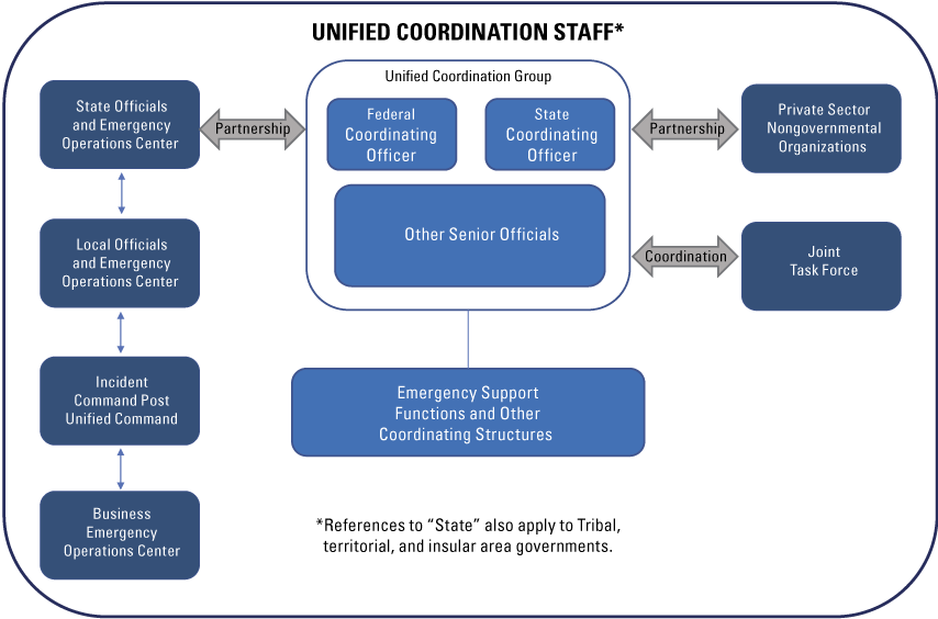
Diagram of a simplified unified coordination organizational structure. Adapted from Federal Emergency Management Agency (2019, fig. 4).
E.4. Linking NEHRP Post-Earthquake Investigations with National Organizational Structures
NEHRP post-earthquake investigation personnel, products, and insights could be an important resource for those conducting the NRF and NDRF activities and other post-earthquake response and recovery operations, providing timely and relevant subject matter expertise and information from ongoing investigations to response and recovery managers, notably emergency managers and building officials. In turn, it is crucial that formal emergency management response activities, particularly life-saving operations, are not impeded by NEHRP post-earthquake investigations. This two-way coordination may require NEHRP representation in the formal disaster response and recovery management structures in place following an earthquake. NEHRP representation would be in addition to specific roles and responsibilities that individual NEHRP agencies have within the NRF and its 15 emergency support functions and the NDRF and its 8 recovery core capabilities and 6 recovery support functions.
A NEHRP representative embedded in the Federal incident command center is recommended to help incident command personnel interpret and incorporate real-time information (particularly as it relates to safety) into response and recovery operations. It is also important that the second-generation plan described in this report, interagency coordination, communication, data sharing, and investigation products be consistent and interchangeable with NIMS incident management systems and practices.
It should be noted, however, that NEHRP itself cannot be directly tasked to perform work since it is not an agency and funds cannot be transferred to it. However, individual NEHRP Agencies may perform response- and recovery-related activities under their own authorities and funding or through reciprocal mutual assistance and reimbursement agreements, and the Agencies do not require a Presidential declaration to do so. Also, with respect to the NRF and NDRF, the individual NEHRP Agencies have some specifically defined roles in the frameworks and also can be, and have previously been, individually tasked to perform response and recovery functions. However, it may be difficult to task and fund non-Federal partner organizations with roles identified in this plan to fulfill key response and recovery functions; and this problem is likely to persist regardless of the linkages made to the NRF or NDRF.
References Cited
Federal Emergency Management Agency [FEMA], 2016, National disaster recovery framework (2d ed.): Federal Emergency Management Agency, 53 p., accessed September 25, 2023, at https://www.fema.gov/emergency-managers/national-preparedness/frameworks/recovery.
Federal Emergency Management Agency [FEMA], 2019, National response framework (4th ed.): Federal Emergency Management Agency, 51 p., accessed September 25, 2023, at https://www.fema.gov/emergency-managers/national-preparedness/frameworks/response.
Abbreviations
AEG
Association of Environmental and Engineering Geologists
ANSS
Advanced National Seismic System
ASCE
American Society of Civil Engineers
ATC
Applied Technology Council
CDC
Centers for Disease Control and Prevention
CEA
California Earthquake Authority
CMT
Clearinghouse Management Team
CREW
Cascadia Region Earthquake Workgroup
CUSEC
Central United States Earthquake Consortium
DHS
U.S. Department of Homeland Security
DOE
U.S. Department of Energy
DOI
Digital Object Identifier
DOT
U.S. Department of Transportation
ECA
Earthquake Country Alliance
ED
U.S. Department of Education
EERI
Earthquake Engineering Research Institute
EHP
Earthquake Hazards Program (USGS)
EIC
Earthquake Investigations Committee
EIS
Earthquake Impact Scale
ENS
Earthquake Notification Service
EPA
U.S. Environmental Protection Agency
ESFs
Emergency Support Functions
FAA
Federal Aviation Administration
FAIR
Findable, Accessible, Interoperable, Reusable
FEMA
Federal Emergency Management Agency
FERC
Federal Energy Regulatory Commission
FHWA
Federal Highway Administration
GAGE
Geodetic Facility for the Advancement of Geoscience
GEER
Geotechnical Extreme Events Reconnaissance
GIS
geographic information system
HHS
U.S. Department of Health and Human Services
HUD
U.S. Department of Housing and Urban Development
ICC
Interagency Coordinating Committee
ICS
Incident Command System
InSAR
interferometric synthetic aperture radar
IRB
Institutional Review Board
JFO
Joint Field Office
lidar
light detection and ranging
MMI
Modified Mercalli Intensity
NASA
National Aeronautics and Space Administration
NDRF
National Disaster Recovery Framework
NEHRP
National Earthquake Hazards Reduction Program
NEIC
National Earthquake Information Center
NGOs
nongovernmental organizations
NHERI
Natural Hazards Engineering Research Infrastructure
NIH
National Institutes of Health
NIMS
National Incident Management System
NIST
National Institute of Standards and Technology
NOAA
National Oceanic and Atmospheric Administration
NRF
National Response Framework
NSF
U.S. National Science Foundation
NTHMP
National Tsunami Hazard Mitigation Program
OES
Office of Emergency Services
PAGER
Prompt Assessment of Global Earthquakes for Response
PCWG
Program Coordination Working Group
PCWG-EIC
Program Coordination Working Group-Earthquake Investigations Committee
PEER
Pacific Earthquake Engineering Research Center
PII
personally identifiable information
PNWER
Pacific Northwest Economic Region
PRP
Project Review Panel
PTC
Project Technical Committee
RAPID
Natural Hazards Reconnaissance Facility
SAGE
Seismological Facility for the Advancement of Geoscience
SEAW
Structural Engineers Association of Washington
SSA
Seismological Society of America
UCG
Unified Coordination Group
USACE
U.S. Army Corps of Engineers
USAID
U.S. Agency for International Development
USGS
U.S. Geological Survey
USNRC
U.S. Nuclear Regulatory Commission
VA
Veterans Administration
For additional information, contact:
Program Coordinator, Earthquake Hazards Program
U.S. Geological Survey
Mail Stop 905
12201 Sunrise Valley Drive
Reston, VA 20192
Publishing support provided by the U.S. Geological Survey Science Publishing Network, Reston Publishing Service Center
Disclaimers
Any use of trade, firm, or product names is for descriptive purposes only and does not imply endorsement by the U.S. Government.
Although this information product, for the most part, is in the public domain, it also may contain copyrighted materials as noted in the text. Permission to reproduce copyrighted items must be secured from the copyright owner.
Suggested Citation
Poland, C., Bray, J.D., Johnson, L., Nikolaou, S., Rathje, E., and Sherrod, B., 2024, Plan to coordinate post-earthquake investigations supported by the National Earthquake Hazards Reduction Program (NEHRP): U.S. Geological Survey Circular 1542, 36 p., https://doi.org/10.3133/cir1542. [Supersedes USGS Circular 1242.]
ISSN: 2330-5703 (online)
ISSN: 1067-084X (print)
Study Area
| Publication type | Report |
|---|---|
| Publication Subtype | USGS Numbered Series |
| Title | Plan to coordinate post-earthquake investigations supported by the National Earthquake Hazards Reduction Program (NEHRP) |
| Series title | Circular |
| Series number | 1542 |
| ISBN | 978-1-4113-4584-3 |
| DOI | 10.3133/cir1542 |
| Publication Date | August 26, 2024 |
| Year Published | 2024 |
| Language | English |
| Publisher | U.S. Geological Survey |
| Publisher location | Reston, VA |
| Contributing office(s) | Earthquake Hazards Program |
| Description | viii, 36 p. |
| Country | United States |
| Online Only (Y/N) | N |
| Additional Online Files (Y/N) | N |