

U.S. Geological Survey Colorado River Basin Science and Technology Collaboration Meetings on Drought (2021)—Synthesis of Findings
Links
- Document: Report (3.05 MB pdf) , HTML , XML
- Data Release: USGS data release - Summary of Responses at the 2021 Colorado River Basin Science and Technology Meetings
- Download citation as: RIS | Dublin Core
Abstract
Ongoing, prolonged, and severe drought and water overuse during the first two decades of the 21st century have reduced water supplies of the Colorado River Basin, with effects cascading to ecosystems and human communities throughout the basin. In June and July 2021, the U.S. Geological Survey (USGS) Colorado River Basin Actionable and Strategic Integrated Science and Technology initiative team held a series of 12 collaboration meetings with USGS scientists and managers to discuss complicated, integrated science challenges and solutions related to drought in the Colorado River Basin. These Science and Technology collaboration meetings were structured to identify challenges experienced by meeting participants when working on complex problems, explore opportunities for coproducing scientific information, and envision future collaborative programs that leverage new technology. The 12 meetings were attended by 79 USGS staff representing 43 unique affiliations (for example, USGS science centers, mission areas, and regional offices). Meeting participants submitted 865 individual responses to six general discussion prompt topics (“Challenges,” “Knowledge Gaps,” “Existing Capabilities,” “Strategies and Actions,” “Example Applications,” and “Next Steps”) using a structured online collaboration tool. However, specific questions or tasks from each general discussion prompt varied by meeting topic. Terms from the USGS Thesaurus (https://apps.usgs.gov/thesaurus/) and USGS Data Lifecycle Model (https://www.usgs.gov/data-management/data-lifecycle) were used to identify and summarize participant responses relevant to science integration, stakeholder engagement, and information management technology. From these responses, opportunities for the Colorado River Basin Actionable and Strategic Integrated Science and Technology initiative to facilitate science integration in the Colorado River Basin are highlighted in this report, including (a) pursuing specific interdisciplinary research topics that require integrating knowledge across spatial and temporal scales, (b) connecting scientists across disciplines, (c) reducing barriers to stakeholder engagement, (d) identifying new technologies, and (e) facilitating data access. Multiple strategies for designing future Science and Technology collaboration meetings are also outlined in this circular to better collect and analyze participant responses.
Introduction
The Colorado River Basin (fig. 1) is affected by continually increasing demand and competition for natural resources, risks from natural hazards, and the effects of severe drought. Indeed, the Colorado River Basin experienced severe drought during the first two decades of the 21st century (Salehabadi and others, 2022; McCabe and others, 2024). Warmer temperatures (Udall and Overpeck, 2017) and water use exceeding supply (Wheeler and others, 2022; Schmidt and others, 2023) contributed to dwindling water resources. In 2020, the U.S. Geological Survey (USGS) initiated the Colorado River Basin Actionable and Strategic Integrated Science and Technology (ASIST) initiative in response to a demonstrated need to build interdisciplinary1 connections and scientific knowledge related to drought conditions and associated effects in the Colorado River Basin (Dahm and others, 2023). The complexities of drought and its effects on human and natural systems in the Colorado River Basin necessitate an interdisciplinary approach to provide the data, tools, and communication to address multiple, interwoven resource-management needs. The ASIST initiative is a regional approach to addressing the grand challenges for integrated USGS science (Jenni and others, 2017, p. 2). Consistent with Jenni and others (2017; p. 20), integrated science is defined in this report as the fusion of data, knowledge, and models from multiple science disciplines using existing and new research and technologies. The principal objective of the Colorado River Basin ASIST initiative is to provide dedicated support for USGS scientists, science centers, programs, partners, or stakeholders to expand and codevelop interdisciplinary science and technology projects related to drought in the Colorado River Basin. In this report, the term “stakeholder” refers to any person or entity with interests in a resource or location (Tillery and others, 2022). References to stakeholders also apply to partners working with the USGS to produce actionable science. In this report, stakeholders and partners are primarily external to the USGS, and include public land and resource managers from local, State, and Federal agencies; Tribal entities; nongovernmental organizations; and the interested public. The Colorado River Basin ASIST initiative supports collaboration among stakeholders, scientists, and technology specialists to efficiently develop and deliver accurate and actionable scientific products and tools to stakeholders (fig. 2).
Glossary terms are shown in boldface text.
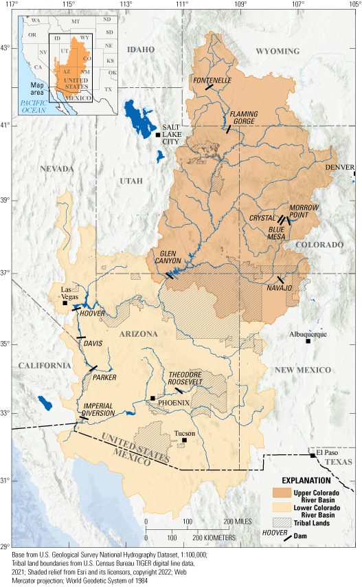
Map showing the location of the Upper and Lower Colorado River Basin. Map modified from Dahm and others (2023).
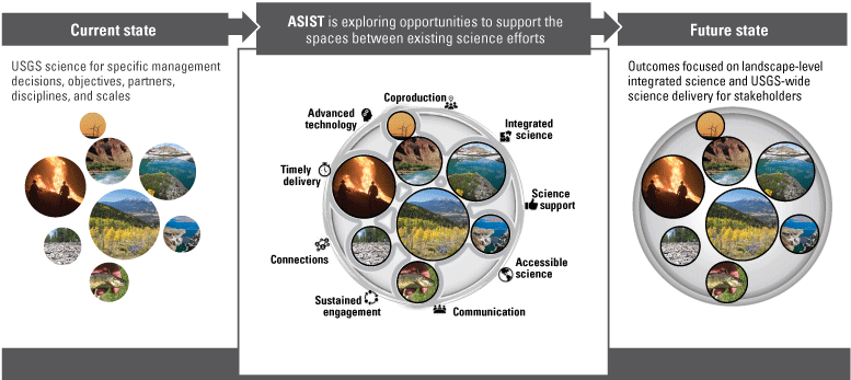
Conceptual diagram for the Colorado River Basin Actionable and Strategic Integrated Science and Technology (ASIST) initiative’s framework for collaboration. This framework takes individual U.S. Geological Survey (USGS) science efforts (left) and finds opportunities for integrating multiple science disciplines, engaging stakeholders, and applying advanced information management technology (middle), to deliver actionable science to stakeholders (right).
To better understand stakeholder science needs related to drought in the Colorado River Basin, members of the Colorado River Basin ASIST initiative reviewed stakeholder communications compiled from more than 200 recently published sources (Frus and others, 2021). These stakeholder communications were used to characterize more than 400 stakeholder science needs by assessing their priorities, strategies, missions, and concerns related to drought. Scientific gaps identified in the Stakeholder Needs Assessment (Frus and others, 2021; Tillery and others, 2022) were used to develop the Colorado River Basin ASIST Science Strategy, determining opportunities and directions for the USGS to expand drought science in the Colorado River Basin (Dahm and others, 2023). The Colorado River Basin ASIST Science Strategy highlights the importance of expanding integration across science disciplines and using advanced information management technology (IMT) to increase efficiency, enhance innovation, and advance ongoing science activities and new science directions related to drought.
In April 2021, in response to the need for integrated science and based on input from USGS experts and challenges identified in the Colorado River Basin ASIST Stakeholder Needs Assessment (Frus and others, 2021; Tillery and others, 2022) and the Colorado River Basin ASIST Science Strategy (Dahm and others, 2023), the Colorado River Basin ASIST team selected 12 topics representing a variety of stakeholder drought science needs and science priorities for discussion (table 1). Members of the Colorado River Basin ASIST team then organized 12 Science and Technology collaboration meetings (hereafter referred to as “S&T meetings”) to discuss each topic. The S&T meetings assembled USGS experts from different science fields related to the 12 topics for discussion of challenges, knowledge gaps, existing capabilities, and solutions related to drought science in the Colorado River Basin. The meetings were also intended to generate science questions and identify (1) technologies that may increase efficiency and innovation related to research, environmental, and societal challenges; (2) opportunities for future engagement among participants; and (3) priorities for the Colorado River Basin ASIST initiative to facilitate integrated science (Dahm and others, 2023). Meeting participants discussed interdisciplinary approaches to develop actionable science and meet stakeholder needs, thereby connecting USGS experts working on complex scientific problems.
Table 1.
Meeting details for the 12 U.S. Geological Survey Colorado River Basin Science and Technology collaboration meetings on drought held virtually in 2021.[Data from Monroe and others (2024). Unique affiliations are the number of different participant-reported work locations such as science centers, mission areas, or regional offices. AI, artificial intelligence; ML, machine learning; HPC, high-performance computing; Cloud, cloud computing]
Approach
The USGS is organized into disciplinarily defined mission areas, each with individual science strategies and programs that support and organize the USGS capacity for addressing complex science problems in coordination with other agencies (Ostroff and others, 2017). As of 2024, the USGS has five mission areas: Core Science Systems, Ecosystems, Energy and Minerals, Natural Hazards, and Water Resources. Each mission area has mission-specific directives, funding models, stakeholder-engagement strategies, and programmatic support for projects conducted by scientists with diverse experience and skillsets, technological capabilities, and science capacities. Summarizing responses from experts from across the USGS required an organizing framework relevant to all mission areas and Colorado River Basin ASIST initiative objectives. A three-part framework was therefore used to gather, summarize, and interpret response data:
-
1. Twelve S&T meeting topics were chosen before responses were collected that contextualize individual responses.
-
2. Six discussion prompt topics were used in all S&T meetings.
-
3. After responses were collected, vocabulary terms for science topics and data lifecycle processes were chosen and used as categories to summarize and compare responses.
A common vocabulary was required to standardize participant responses across a diversity of training, duties, and backgrounds and to compare response terms with the terms also used in the Stakeholder Needs Assessment (Frus and others, 2021; Tillery and others, 2022). Vocabulary terms from the USGS Thesaurus (USGS, 2022b) and the USGS Data Lifecycle Model (Faundeen and others, 2014) were chosen to summarize participant responses to meeting topics and discussion prompts. There were two additional considerations that motivated our creation of a common vocabulary: (1) maintaining cohesion with ongoing focus areas of Colorado River Basin ASIST, including integrated science (Dahm and others, 2023), stakeholder engagement (Tillery and others, 2022), and IMT (Anderson and others, 2022), and (2) using an organizing framework relevant to all mission areas and Colorado River Basin ASIST initiative objectives to inform future collaborative meetings.
Science and Technology Collaboration Meetings
In June and July 2021, experts from USGS science centers and mission areas across the United States were invited to participate in 1 or more 3-hour online meetings, each centered on 1 of 12 topics related to drought in the Colorado River Basin (table 1). Outreach materials (announcements, information about meeting topics, save-the-dates, and registration links) were distributed through the Rocky Mountain Region Science Exchange, the Colorado River Basin ASIST email lists, the Rocky Mountain Regional Director, center directors from the USGS Rocky Mountain and Southwest Regions, the USGS Community for Data Integration, the USGS Risk Research and Applications Community of Practice, and the S&T meeting participants. Meetings were held virtually during regular work hours, and no additional compensation was offered to participants for their participation. Microsoft Teams software was used for meetings and to solicit participant input using a virtual whiteboard (fig. 3). In addition to providing information on their professional background, participants contributed free-form responses to six open-ended prompts motivating discussions specific to each meeting topic: (1) “Challenges,” (2) “Existing Capabilities,” (3) “Example Applications,” (4) “Knowledge Gaps,” (5) “Strategies and Actions,” and (6) “Next Steps.” Refer to table 2 for further details on each prompt. General discussion prompts were initially modified for relevance to each meeting topic (for example, “Brainstorm challenges related to integrated science to study groundwater-dependent streams, ecosystems, and research in the Colorado River Basin” was used for the Groundwater-Dependent Ecosystems meeting), but additional questions could be posed by the facilitator based on the participants in attendance and what was previously discussed during the meeting.
Table 2.
Discussion prompts and definitions for the 12 U.S. Geological Survey Colorado River Basin Science and Technology collaboration meetings on drought held virtually in June and July 2021.Participant responses were recorded on individual “sticky notes” on the virtual whiteboard, and popular responses could be electronically upvoted by fellow participants wishing to emphasize similar ideas (fig. 3). Typical responses were in the form of complete sentences or sentence fragments and were qualitative in nature. For example, one response to the “Challenges” prompt in the meeting about climate change (table 1) was “Understanding what type of information stakeholders and decision makers need most and in what form” (fig. 3). After all collaboration meetings were completed, participant responses were exported to a spreadsheet, organized by meeting topic and discussion prompt, and upvotes for each response were tallied.
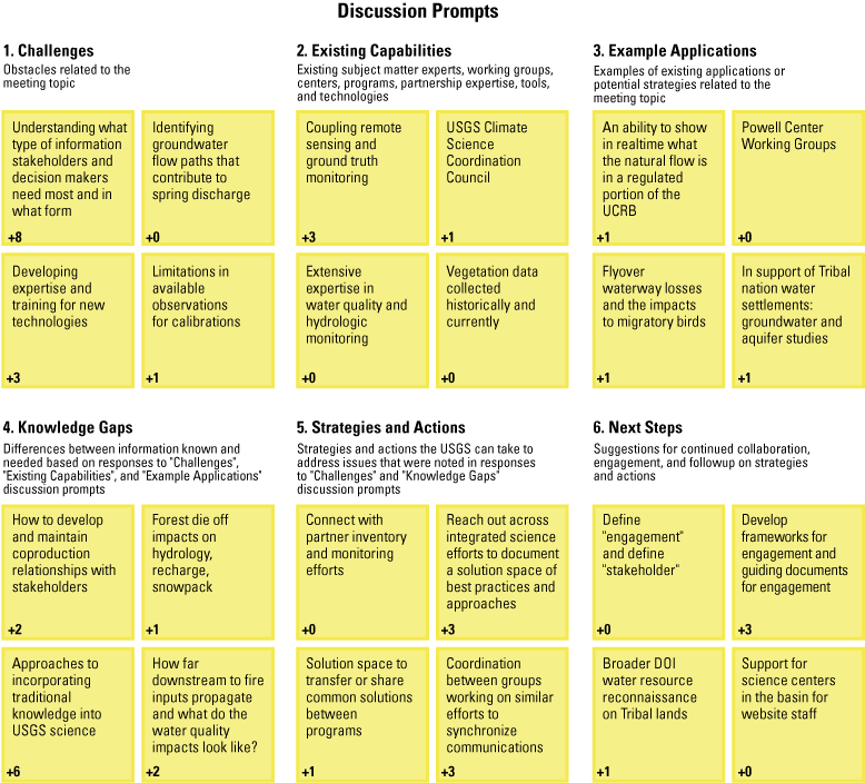
Diagram of a virtual whiteboard setup example with the six discussion prompts provided to participants, actual responses submitted by U.S. Geological Survey (USGS) participants (yellow sticky notes), and the number of upvotes for each response (bottom left of each sticky note) during their respective Science and Technology collaboration meetings held virtually in June and July 2021. Wording provided by Science and Technology collaboration meeting participants has been retained verbatim, except for minor additions and modifications made to improve clarity. (DOI, U.S. Department of the Interior; UCRB, Upper Colorado River Basin).
Response Summary
After collecting participant responses, USGS Thesaurus terms were used to organize response data (USGS, 2022b). The USGS Thesaurus was created to categorize science topics and methods and was previously used by the Colorado River Basin ASIST team to organize stakeholder communications (Frus and others, 2021; Tillery and others, 2022). The hierarchy of the USGS Thesaurus also allows for collapsing or expanding terms into precise categories, thereby facilitating the analysis of responses without losing information. Each response was examined for relation to one or more USGS Thesaurus terms used in the Stakeholder Needs Assessment (Frus and others, 2021). The Stakeholder Needs Assessment list consisted of 73 thesaurus terms, and 5 additional terms were added from the USGS Thesaurus (USGS, 2022b) to better characterize S&T meeting responses (78 terms total; for additional details, please refer to Monroe and others, 2024). To increase the relevance of response characterization to IMT, we also assigned as many as five terms from the USGS Data Lifecycle Model (Faundeen and others, 2014) to each response (“acquire,” “process,” “analyze,” “preserve,” and “publish”). We did not use the term “plan” as this was not a focus of meeting discussions, but we recognize its importance for the USGS Data Lifecycle Model (Faundeen and others, 2014). Terms from the USGS Thesaurus and the USGS Data Lifecycle Model were then used to identify and summarize responses relevant to three Colorado River Basin ASIST priorities: integrated science, stakeholder engagement, and IMT. Terms from the USGS Data Lifecycle Model were only used to summarize responses for IMT. Terms assigned to each response are available as a USGS data release (Monroe and others, 2024). Discussion prompts and meeting names also were used to provide additional context to responses. The first author of this report assigned terms, and they were reviewed by multiple Colorado River Basin ASIST team members. Summaries were restricted to unique responses and upvotes were not used to weigh summaries.
Outcomes
From the 12 meetings, 865 individual responses were registered from 79 participants representing 43 unique affiliations (self-reported work locations of city, science centers, mission areas, or regional offices; table 1). Many participants (30 participants, 38 percent) attended more than one meeting. Participants represented a variety of science disciplines including chemistry, computer science, ecology, geography, geology, geomorphology, hydrology, and social sciences. Data collected in the S&T meetings likely constitute the most expansive interdisciplinary input as of 2024 within the USGS for science and technology priorities specific to the Colorado River Basin. The discussion prompts with the greatest number of responses were “Challenges” (217) and “Existing Capabilities” (199) followed by “Knowledge Gaps” (137), “Strategies and Actions” (127), “Example Applications” (120), and “Next Steps” (65). The USGS Thesaurus is organized as a hierarchy and the highest-level terms (Tier 1) are grouped into categories that include “Methods,” “Product types,” “Sciences,” and “Topics.” (The “Topics” category is further defined as “themes, subjects, and concerns for which USGS information resources are relevant”; USGS, 2022b.) Among the top 20 (out of 78) USGS Thesaurus terms assigned to responses across all S&T meetings, terms common to both the S&T meetings and the Stakeholder Needs Assessment (Frus and others, 2021; Tillery and others, 2022; fig. 4) were almost exclusively in the “Topics” category (9 out of 10 terms; Monroe and others, 2024). Conversely, most USGS Thesaurus terms seldom assigned in the Stakeholder Needs Assessment (less than 10 out of 484 science needs, or less than 3 percent) but frequently assigned in the S&T meetings were in the categories “Methods” (5 out of 10 terms) or “Product types” (1 out of 10 terms; Monroe and others, 2024; fig. 4). This result reflects a more technical focus of many responses from S&T meetings compared with responses from the Stakeholder Needs Assessment (Frus and others, 2021).
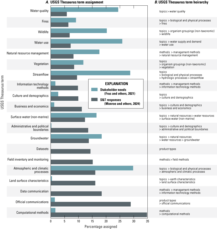
Histogram showing A, the percentage of responses from the 2021 Science and Technology (S&T) collaboration meeting (865 total responses) and the Stakeholder Needs Assessment (484 total responses) that are assigned to U.S. Geological Survey (USGS) Thesaurus (USGS, 2022b) terms, and B, the hierarchical categories of the USGS Thesaurus terms. Out of the 78 USGS Thesaurus terms assigned to unique responses, only the 20 most frequently assigned to S&T meeting responses are shown.
Responses Relevant to Integrated Science
We determined whether terms belonged to the “Sciences” and “Topics” groupings from the highest hierarchical level of the USGS Thesaurus (Tier 1 terms; USGS, 2022b) to classify terms as “science-related.” Many responses from the 12 S&T meetings were assigned multiple science-related terms, indicating integrated science (Monroe and others, 2024). Examples of integrated science projects mentioned in participant responses include web-based visualization tools; public-facing, plain-language web pages of scientific information; existing integrated science projects; and proposed models to predict effects of climate scenarios by integrating physical and biological processes. However, rather than being representative of integrated science, examples in responses were often about delivering and visualizing independent datasets, such as broad-based scientific information and tools for public consumption and decision making (for example, water use; Eberts and others, 2019) or geography-specific science projects, including USGS Vizlab water data visualizations (USGS, 2019) and the USGS Smart Energy Tool (USGS, 2022a). Responses from the “Existing Capabilities” prompt were largely related to understanding and visualizing current and former water supplies in the western United States and were generally restricted to model simulations for scenario prediction.
Integrated science needs were commonly reported in the Groundwater-Dependent Ecosystems, Climate Change, and Ecosystem Responses S&T meetings and in the methods-based S&T meetings (for example, Innovative Data Collection; table 1). Participants proposed models and research about hydrology, ecology, or both to study links among climate, surface water, groundwater, vegetation, and wildlife dynamics. Responses to the “Knowledge Gaps” prompt during the Innovative Data Collection and Climate Change meetings identified the lack of interdisciplinary research, such as research on how shifts in precipitation patterns alter vegetation dynamics and affect human systems. The Groundwater-Dependent Ecosystems, Climate Change, and Innovative Data Collection meetings identified the need to understand groundwater mechanisms (for example, recharge, residence time, discharge) and their effects on aquatic and terrestrial ecosystems. Responses also highlighted a need for efficient decision-making tools to understand and predict broad dynamics among climate, soils, vegetation, and hydrology. The Innovative Data Collection meeting and the Artificial Intelligence, Machine Learning, Cloud Computing, and High-Performance Computing (AI, ML, Cloud, and HPC) meeting (table 1) reported the need for an efficient, integrated model for planning and management purposes and information integration to improve research and applications across spatial and temporal scales. Other meeting responses suggested the need for interdisciplinary research addressing the cascading effects of extreme drought on reservoir dynamics, fires or mine drainage on water quality, and drought on human health.
The term “atmospheric and climatic processes” was frequently assigned to responses in the Stakeholder Needs Assessment (Frus and others, 2021). During the S&T meetings, many “Existing Capabilities” discussion prompt responses that we assigned with the term “atmospheric and climate processes” were related to various aspects of drought. These responses mentioned a growing number of interdisciplinary drought metrics, predictive capabilities, and early warning prototypes, such as the Drought Early Warning System (National Integrated Drought Information System, 2021) and the Landscape Evaporative Response Index (Rangwala and others, 2019). Participants suggested using existing partnerships with the National Oceanic and Atmospheric Administration (NOAA), National Aeronautics and Space Administration (NASA), and Climate Adaptation Science Centers, and tools such as National Integrated Drought Information System drought monitoring data, to leverage and expand capabilities related to drought science.
Many Colorado River Basin stakeholders identified science needs that included the ability to monitor, analyze, and predict landscape changes and effects related to drought (Frus and others, 2021). Correspondingly, USGS participants in the S&T meetings suggested that sufficient capabilities exist to expand projects integrating climate, land use, air quality, snowpack, and water availability data in the Colorado River Basin. Such approaches would address gaps in understanding how multiple system components are linked, and how links could vary under a changing climate. Participants from the USGS also referenced recent progress in technological and computational capabilities to advance water science, such as the USGS Integrated Water Availability Assessments (IWAAs; Miller and others, 2020). When fully implemented, the IWAAs are designed to provide seasonal to decadal forecasts of water availability and insights into the drivers affecting such forecasts.
Responses Relevant to Stakeholder Engagement
Coproduction creates actionable science through collaboration between researchers and science end users (Meadow and others, 2015). Expanding integrated science requires repeated engagement with stakeholders to understand interdisciplinary science needs and delivery methods related to drought. Determining successful examples of interdisciplinary engagement with new and existing stakeholders can facilitate the coproduction of data and science (Dahm and others, 2023). Participants identified successful examples of stakeholder engagement, including the North American Bat Monitoring Program (NABat; Reichert and others, 2021), IWAAs, using art to communicate ecological risk at uranium mines (Velasco, 2021), and examples of coproduction among Federal agencies and stakeholders. Examples of such projects are the Wyoming Landscape Conservation Initiative (Anderson and others, 2021) and ARIES (Artificial Intelligence for Environment and Sustainability; Villa and others, 2009). Participants also mentioned collaboration venues such as the USGS John Wesley Powell Center, which is described in Baron and Goldhaber (2011). Participant responses related to stakeholder engagement also focused on collections of information in virtual locations such as registries, online science portals, data visualizations, and web pages disseminating science to the public and stakeholders. Organizations, roles, and principles from the USGS that support and guide new and continuing collaboration, communication, outreach, and science dissemination include the USGS Office of Tribal Relations, Water Mission Area communications coordinator, communities of practice, Integrated Information Dissemination Division, Office of Communications and Publishing training classes and other USGS trainings on collaboration, and Office of Collaborative Action and Dispute Resolution. Participant responses related to resources that support stakeholder engagement and coproduction of science include the USGS and Bureau of Land Management coproduction toolkit (Selby and others, 2023) and the Colorado River Basin ASIST Stakeholder Needs Assessment (Frus and others, 2021).
Comprehensive interdisciplinary science typically involves engaging with multiple stakeholders. Stakeholder engagement can occur across a continuum (refer to fig. 2 in Tillery and others, 2022), and participants in the S&T meetings acknowledged varying approaches to engagement with stakeholders across USGS. Participants repeatedly highlighted how challenging it was to incorporate engagement activities for varying interest levels, especially when conducting interdisciplinary science. A common barrier identified by meeting participants was a lack of communication and coordination among USGS specialists regarding their knowledge of stakeholder needs. Many USGS scientists work with individual stakeholders with whom they have a positive and meaningful rapport. Whereas such relationships are a necessary and functional approach, these relationships can unintentionally exclude other stakeholders during collaborative projects. In addition, participants reported minimal crossover knowledge of stakeholder science needs among USGS research groups and a lack of information about stakeholder decision-making processes and the spatial extents and timing needed for actionable science data and delivery. Lack of internal coordination reduces the USGS’s ability to identify shared stakeholder science needs, leverage work across USGS expertise, and develop and integrate science tools to address complex challenges at varying spatial and temporal scales. The following list includes some of the common responses to “Challenges” and “Knowledge Gaps” discussion prompts from S&T meeting participants:
-
• Understanding stakeholder priorities and the decision-making contexts of diverse stakeholders,
-
• Addressing conflicts among stakeholder ideas and priorities,
-
• Developing and maintaining coproduction relationships with stakeholders,
-
• Maintaining continuity amid stakeholder staffing changes, and
-
• Applying broad participation to be less dependent on a few individuals.
Meeting participants also highlighted a need for engagement strategies and communication planning across USGS science centers. Participants indicated that, without these strategies and plans, stakeholders might be contacted repeatedly by numerous USGS investigators from multiple projects, increasing fatigue or confusion about their roles or project outcomes. Sharing project plans across the USGS to engage and communicate with stakeholders could reduce burdens on stakeholders, identify ways to integrate science projects, and lead to improved relationships and willingness to participate among stakeholders. Additional internal USGS barriers to successful stakeholder engagement reported by participants included understanding current and future capacity in scientific communication, identifying skills and resources needed for successful stakeholder engagement, and having adequate institutional support (providing staff the time and capacity to work on integrated science with stakeholders, encouraging stakeholder engagement, and including stakeholder engagement in performance metrics) for staff and primary investigators to engage and coproduce science.
Suggested strategies and actions from participants for successful stakeholder engagement centered almost exclusively on administrative actions to increase engagement skills and capacity. For example, participants recommended the USGS develop a network of stakeholders the USGS scientists could access to disseminate information and solicit feedback. A coordinated approach to such a network could identify shared stakeholder needs, consider diverse perspectives, provide stakeholders access to the entirety of USGS expertise, leverage best practices from multiple engagement models, and track and communicate engagement activities.
Developing relevant skills among USGS staff was recognized as a need for successful stakeholder engagement. Participants recommended internal USGS training about how to host and facilitate meetings for stakeholder engagement. Suggestions included holding “brown bag” seminars (informal meetings during lunchtime) about engagement strategies and workshops to exchange ideas for effective stakeholder engagement. Training scientists can increase the quality of stakeholder engagements and encourage stakeholder participation, potentially increasing relevance and applicability of USGS data and products. Other related ideas from participants included (a) using technology and social media to improve data and concept visualizations by platforms such as websites or geonarratives, (b) developing acceptable approaches to use and release data belonging to stakeholders, and (c) providing USGS managers and investigators with program or project materials to assist with external meetings.
Responses Relevant to Information Management Technology
Integration and delivery of science related to decades-long drought conditions in the Colorado River Basin depend on leveraging existing or new IMT resources (Anderson and others, 2022). Among existing IMT resources, participants appreciated the USGS Community for Data Integration-sponsored communities of practice, a group dedicated to increasing knowledge and capacity in working with scientific data (https://www.usgs.gov/centers/community-for-data-integration-cdi). Several responses highlighted data-oriented programs available or in development including NABat (Reichert and others, 2021), tools to make precipitation forecasts using soil and seed germination data in the Southwest (Pilliod and others, 2018; J. Bradford, U.S. Geological Survey, written commun., 2023), integration of hydrologic data with geospatial science in web applications (such as Miller and others, 2022), and collaborations among the USGS, NASA, and NOAA through the Earth Science Information Partners community (https://www.esipfed.org/).
Meeting participants indicated several challenges related to incorporating IMT into research development and delivery. Out of 40 responses to “Challenges” and “Knowledge Gaps” discussion prompts, most were related to the USGS Data Lifecycle Model terms “acquire” (30 responses), “analyze” (26 responses), and “process” (18 responses), and fewer were related to “publish” (6 responses) and “preserve” (5 responses). The prevalence of these terms indicates a greater emphasis on data collection and analysis rather than infrastructure for storage and distribution. A common challenge noted by participants was the time and effort needed to develop expertise and obtain necessary training for new IMT technologies or to find relevant expertise among current USGS employees. Participants reported that specialized skill sets, such as coding in JavaScript, developing visualizations, and using artificial intelligence and machine learning use, are needed but often lacking among USGS staff. Participants also indicated the importance of understanding which tools are required. For example, whether a web map, a geonarrative, a custom application, or Tableau Software would be the best method to prepare data visualizations and interpretations. The need for additional guidance on producing visualizations was noted among responses, including publishing requirements and how those requirements relate to the concurrent timing of data releases. Another reported IMT challenge was understanding the types and forms of information needed most by stakeholders and decision makers. Researchers and managers may be using different IMT systems, and a disconnect was observed between research data and delivery of those data through potential data visualization or decision support tools.
Participants also commonly identified challenges in developing integrated research as challenges for IMT. Data collection is usually not proactively designed to facilitate the integration of research encompassing variables from diverse topics, including climate, soil, vegetation, surface water, fish, and groundwater. Participants also highlighted problems with data availability at relevant spatial and temporal scales. For instance, participants explained that the effects of human systems on water use (such as diversions and pumping) are not characterized at the fine spatial scale where these effects take place. Similarly, participants pointed to a lack of livestock grazing data that could be spatially and temporally related to drought and vegetation status or streamflow and groundwater-level data and a lack of “long-term” data on small headwater streams. Another challenge participants associated with scale is the inability to discern between non-native and native riparian species with available imagery; this could create difficulties when mapping invasive species spread or evaluating restoration treatments. Participants frequently noted the need for fine-resolution, spatially explicit data for downscaling and modeling physical processes, such as snowpack dynamics. Yet participants observed the use and release of such data may be challenging, and guidance is needed when research products include data belonging to various stakeholders or data collected from private lands. Other technical barriers identified by participants included moving field data into databases and the lack of examples of machine learning models to apply to other research needs. Participants reported challenges when working with large datasets derived from multiple sources, such as when compiling, harmonizing, analyzing, and visualizing data. Standardizing data types across the USGS, such as by colocating measurements and addressing mismatches in scale and units, could produce and deliver real-time or forecasted data and data products. Such standardization would also accommodate a diversity of use cases, data and application types, and the development of best practices. Projects mentioned with successful data standardization include ARIES and the USA National Phenology Network (https://www.usanpn.org/). As a semantic web-based technology, ARIES integrates data and models and disseminates science to stakeholders (Villa and others, 2009). The USA National Phenology Network assembles, processes, and releases phenological data products (Schwartz and others, 2012) and complies with Federal open-data policies as required by the Foundations for Evidence-Based Policymaking Act of 2018 (Pub. L. 115-435; Rosemartin and others, 2018).
Several strategies and next steps were proposed by participants, including creating a flowchart describing the workflow for releasing data visualizations that meet USGS Fundamental Science Practices requirements (Fundamental Science Practices Advisory Council, 2023). Other suggestions arose from the need for greater public awareness of research conducted by USGS staff. Awareness could be increased with web maps searchable by region or, specifically for the USGS Tribal Lands Locator Toolkit (https://arcg.is/0LSD9f0), adding fields that expand information on existing connections between Tribes and USGS scientists. Participants also proposed additional coordination among USGS researchers regarding the scope of field-sensor use and deployment, such as recommending a closer look at Next Generation Water Observing System projects in the Delaware River Basin and other basins for transferrable IMT features (Murdoch and others, 2022). Finally, a broad-scope pilot project in the Colorado River Basin was suggested wherein region-wide data services, data-management processes, and remote-monitoring data access could be examined and tested. Such a pilot project could include training integrated sensor technicians and establishing multipurpose installations (for example, multiple sensors, videos, infrared, and low-cost acoustics) to share benefits and potentially increase analytic capacities.
Summarizing Participant Input—Success and Limitations
Grouping responses by discussion prompts allowed the Colorado River Basin ASIST team to efficiently search for responses by topics such as “Knowledge Gaps,” “Example Applications,” or “Strategies and Actions.” Discussion prompts also offered helpful context when responses lacked details, such as only mentioning a project name or website. This assessment also represents the first known application of terms from the USGS Data Lifecycle Model (Faundeen and others, 2014) to characterize and summarize responses. Using five USGS Data Lifecycle Model terms (“acquire,” “process,” “analyze,” “preserve,” and “publish”) provided insights beyond what was revealed from our set of USGS Thesaurus terms (USGS, 2022b; Monroe and others, 2024).
Meeting structures and terms assigned to participant responses were used with mixed success to extract insights relevant to integrated science, stakeholder engagement, and IMT. For example, existing integrated science projects discussed in the meetings often included data delivery and visualization websites, rather than examples of integrated research. The lack of integrated research examples suggests either limits to our approach of identifying responses assigned with more than one science-related term (Monroe and others, 2024) or that integrated science examples were underrepresented among responses. It is also possible that truly integrated research is still uncommon in practice.
This assessment also revealed challenges with summarizing and interpreting responses to questions relevant to the Colorado River Basin ASIST initiative. Some challenges were inevitable given the qualitative and exploratory nature of these meetings, and, therefore, the inability to foresee exactly what the response data would look like and how those data should be analyzed. The data-analysis approach was also hampered by the subjective nature of categorizing qualitative responses using USGS Thesaurus terms (USGS, 2022b). Interpreting USGS participant responses using the lens defined by the Stakeholder Needs Assessment (Frus and others, 2021) enabled direct comparison between the datasets (fig. 4) but also contributed to potential information loss when the USGS Thesaurus terms were too general. The focus on science-related terms reduced specificity among more methodological terms related to IMT, represented by only three USGS Thesaurus terms (“information technology methods,” “computational methods,” and “data communication”). Using broad terms to search for responses also created challenges in summarizing numerous responses (for example, there were 86 responses to the “Existing Capabilities” discussion prompt assigned with IMT-related terms; Monroe and others, 2024). Finally, it should be emphasized that the responses reported here do not represent a complete census of science needs and capabilities related to drought in the Colorado River Basin. In addition to USGS staff that did not attend, some participants may have attended to listen and learn rather than provide input (nonresponse bias). Similarly, the upvote feature of the virtual whiteboard likely reduced redundancy among responses and allowed participants to indicate consensus during discussions. However, because voting was apparently used inconsistently, and the use of upvoting likely depended on factors including meeting topic, the number of participants, and their propensity to engage, it was difficult to use and interpret this metric across the different S&T meetings. As such, upvotes could not be used as an affirmation or prioritization of responses.
Future S&T meetings could benefit from designing analysis-ready data collection strategies. The USGS Thesaurus terms (USGS, 2022b) used for the Stakeholder Needs Assessment (Frus and others, 2021) constrained our inferences regarding IMT challenges and needs, suggesting the importance of selecting the terms most relevant to subsequent analysis. Responses could also be ambiguous, contributing to subjectivity in assigning terms, increasing uncertainty, and reducing reproducibility. Allowing participants to select their own USGS Thesaurus terms or having a discussion on common terminology among interdisciplinary groups could reduce subsequent ambiguity and subjectivity when summarizing responses. Collecting, interpreting, and summarizing responses can be improved with more systematic approaches such as qualitative coding (Guest and others, 2012) and affinity mapping and clustering (Scupin, 1997). Furthermore, whereas responses were submitted anonymously for this study, the ability to identify response authors could allow for followup and clarification, but that capability should be weighed with effects on participation and privacy concerns. Additional consideration also is needed on how to apply or modify the upvote function, for example, by requiring all participants to rank each response by importance. Finally, depending on the meeting topic and objectives, the number of discussion prompts could be expanded or refined, for example, along administrative, scientific, or technical themes.
Main Takeaways for Integrated Science Planning
In addition to the benefits of convening USGS staff to develop integrated science questions and approaches related to drought in the Colorado River Basin, staff from several USGS projects and programs expressed interest in using insights from participant responses to enhance their own disciplinary-focused project teams. To that end, the following lists of priorities for integrated science, stakeholder engagement, and IMT use are offered. After ranking 137 responses to the “Knowledge Gaps” discussion prompt by the number of science-related terms (Monroe and others, 2024), responses were synthesized into priorities for integrated science in Box 1.
Box 1. Priorities for integrated science related to drought in the Colorado River Basin based on responses from U.S. Geological Survey participants of the 2021 Science and Technology collaboration meetings.
• Developing models and research to study links among climate, surface water, groundwater, vegetation, and wildlife dynamics.
• Understanding how variations in precipitation patterns alter vegetation dynamics and affect human systems.
• Understanding groundwater mechanisms (for example, recharge and residence time) that affect aquatic and terrestrial systems.
• Using models and information to understand and predict broad dynamics among climate, soils, vegetation, and hydrology across spatial and temporal scales for plans, management, and decision-making tools related to drought.
• Understanding the effects of extreme drought on reservoir dynamics and human health.
• Understanding the effects of fires and mines on water quality.
Searching for responses mentioning tools (such as technology, training, and best practices) and barriers to successful stakeholder engagement (58 responses from “Challenges,” “Knowledge Gaps,” and “Strategies and Actions” discussion prompts) or responses mentioning applications of IMT (162 responses from all discussion prompts) identified strategies and roles for the Colorado River Basin ASIST initiative to facilitate integrated science in the Basin (Monroe and others, 2024). Based on these responses, priority actions are listed to facilitate stakeholder engagement (Box 2) and to develop IMT (Box 3) for USGS scientists researching drought-related integrated science in the Colorado River Basin.
Box 2. Priorities to facilitate stakeholder engagement related to integrated science and drought in the Colorado River Basin based on responses from the U.S. Geological Survey (USGS) participants of the 2021 Science and Technology collaboration meetings.
• Ensuring adequate institutional support, such as offering employees the time and capacity [to work on integrated science with stakeholders], encouraging participation, and including stakeholder engagement in performance metrics.
• Coordinating stakeholder engagement strategies across USGS science centers.
• Improving communications with stakeholders, particularly emphasizing higher-quality and more effective communication tools including data and knowledge visualizations.
• Developing acceptable approaches to the use and release of potentially proprietary data belonging to various stakeholders.
• Designing approaches for identifying shared stakeholder needs, such as considering diverse perspectives, providing stakeholders access to all USGS expertise, leveraging best practices from across engagement models, and tracking and communicating engagement activities.
Box 3. Priorities for information management technology development related to integrated science and drought in the Colorado River Basin based on responses from the U.S. Geological Survey (USGS) participants of the 2021 Science and Technology collaboration meetings.
• Standardizing diverse data types.
• Developing and implementing advanced technology solutions for data integration.
• Initiating pilot projects to examine and test region-wide data services, data-management processes, and remote-monitoring data accessibility while increasing awareness of resources and experiences within the USGS.
• Addressing problems of inadequate data at relevant scales, including the need for fine-resolution, spatially explicit data for downscaling and modeling physical processes.
Conclusions
In response to decades-long, severe drought across the Colorado River Basin, in 2021, the U.S. Geological Survey (USGS) Colorado River Basin Actionable and Strategic Integrated Science and Technology (ASIST) initiative held 12 Science and Technology collaboration (S&T) meetings with USGS staff to discuss complex issues related to drought. Conversations related to each meeting topic were facilitated by a series of discussion prompts, and responses from participants were interpreted and summarized using terms from the USGS Thesaurus and the USGS Data Lifecycle Model. Contrasting information from the S&T meetings with information from a 2021 stakeholder needs assessment highlighted the science information and processes prioritized by the USGS and other stakeholders. Participant responses also prioritized integrated science, stakeholder engagement, and information management technology to address drought-related science needs in the Colorado River Basin. The organization and summary of responses collected during the S&T meetings proved invaluable for continuing collaboration and integration efforts, including a workshop for codesign held by the Colorado River Basin ASIST team in 2023. Three broad themes (integrated science, stakeholder engagement, and information management technology) were again emphasized for codesign discussions based on the goals of the Colorado River Basin ASIST initiative and priorities elevated by scientists during the S&T meetings. Priority issues and lessons learned from this assessment will help foster the continued improvement of collaboration and integration efforts by the Colorado River Basin ASIST team and across the USGS.
References Cited
Anderson, E.D., Erxleben, J.R., Qi, S.L., Monroe, A.P., and Dahm, K.G., 2022, U.S. Geological Survey Colorado River Basin Actionable and Strategic Integrated Science and Technology (ASIST)—Information Management Technology Plan: U.S. Geological Survey Fact Sheet 2022–3051, 4 p., accessed July 2023 at https://doi.org/10.3133/fs20223051.
Anderson, P.J., Aldridge, C.L., Alexander, J.S., Assal, T.J., Aulenbach, S., Bowen, Z.H., Chalfoun, A.D., Chong, G.W., Copeland, H., Edmunds, D.R., Germaine, S., Graves, T., Heinrichs, J.A., Homer, C.G., Huber, C.C., Johnston, A., Kauffman, M.J., Manier, D.J., McShane, R.R., Eddy-Miller, C.A., Miller, K.A., Monroe, A.P., O’Donnell, M.S., Ortega, A., Walters, A.W., Wieferich, D, Wyckoff, T.B., and Zeigenfuss, L., 2021, U.S. Geological Survey science for the Wyoming Landscape Conservation Initiative—2018 annual report: U.S. Geological Survey Open-File Report 2021–1067, 33 p., accessed April 2023 at https://doi.org/10.3133/ofr20211067.
Baron, J., and Goldhaber, M., 2011, The John Wesley Powell Center for Analysis and Synthesis: U.S. Geological Survey Fact Sheet 2011–3066, 2 p., accessed April 2023 at https://doi.org/10.3133/fs20113066.
Beier, P., Hansen, L.J., Helbrecht, L., and Behar, D., 2016, A how-to guide for coproduction of actionable science: Conservation Letters, v. 10, no. 3, p. 288–296, accessed December 11, 2024, at https://doi.org/10.1111/conl.12300.
Dahm, K.G., Hawbaker, T., Frus, R.J., Monroe, A.P., Bradford, J.B., Andrews, W.J., Torregrosa, A., Anderson, E.D., Dean, D., and Qi, S.L., 2023, Colorado River Basin Actionable and Strategic Integrated Science and Technology Project—Science strategy: U.S. Geological Survey Circular 1502, 57 p., accessed August 2022 at https://doi.org/10.3133/cir1502.
Eberts, S.M., Wagner, C.R., and Woodside, M.D., 2019, Water priorities for the Nation—The U.S. Geological Survey Next Generation Water Observing System: U.S. Geological Survey Fact Sheet 2019–3046, 2 p., accessed January 25, 2024, at https://doi.org/10.3133/fs20193046.
Faundeen, J.L., Burley, T.E., Carlino, J.A., Govoni, D.L., Henkel, H.S., Holl, S.L., Hutchison, V.B., Martín, E., Montgomery, E.T., Ladino, C.C., Tessler, S., and Zolly, L.S., 2014, The United States Geological Survey Data Lifecycle Model: U.S. Geological Survey Open-File Report 2013–1265, 4 p., accessed August 2022 at https://doi.org/10.3133/ofr20131265.
Fleming, A., Bohensky, E., Dutra, L.X.C., Lin, B.B., Melbourne-Thomas, J., Moore, T., Stone-Jovicich, S., Tozer, C., Clarke, J.M., Donegan, L., Hopkins, M., Merson, S., Remenyi, T., Swirepik, A., and Vertigan, C., 2023, Perceptions of co-design, co-development and co-delivery (Co-3D) as part of the co-production process—Insights for climate services: Climate Services, v. 30, no. 100364, 10 p., accessed December 10, 2024, at https://doi.org/10.1016/j.cliser.2023.100364.
Fundamental Science Practices Advisory Council, 2023, Update on U.S. Geological Survey Fundamental Science Practices: U.S. Geological Survey Circular 1503, 6 p., accessed August 16, 2024, at https://doi.org/10.3133/cir1503.
Frus, R.J., Hawbaker, T.J., Anderson, E.D., Anderson, P.J., Andrews, W.J., Bradford, J.B., Dean, D.J., Duniway, M.C., Horton, R.J., Jones, D.K., Monroe, A.P., Qi, S.L., Skinner, C., Thomas, K.A., Tillery, A.C., Torregrosa, A., and Dahm, K.G., 2021, A snapshot of stakeholder science needs related to drought in the Colorado River Basin: U.S. Geological Survey data release, accessed August 2022 at https://doi.org/10.5066/P9CTXP26.
Guest, G., MacQueen, K.M., and Namey, E.E., 2012, Applied thematic analysis: Los Angeles, SAGE Publications, Inc., 320 p., accessed February 6, 2024, at https://doi.org/10.4135/9781483384436.
Jenni, K.E., Goldhaber, M.B., Betancourt, J.L., Baron, J.S.,Bristol, R.S., Cantrill, M. Exter, P.E., Focazio, M.J., Haines, J.W., Hay, L.E., Hsu, L., Labson, V.F., Lafferty, K.D., Ludwig, K.A., Milly, P.C., Morelli, T.L., Morman, S.A., Nassar, N.T., Newman, T.R., Ostroff, A.C., Read, J.S., Reed, S.C., Shapiro, C.D., Smith, R.A., Sanford, W.E., Sohl, T.L., Stets, E.G., Terando, A.J., Tillitt, D.E., Tischler, M.A., Toccalino, P.L., Wald, D.J., Waldrop, M.P., Wein, A., Weltzin, J.F., and Zimmerman, C.E., 2017, Grand challenges for integrated USGS science—A workshop report: U.S. Geological Survey Open-File Report 2017–1076, 94 p., accessed February 1, 2023, at https://doi.org/10.3133/ofr20171076.
Lyall, C., Bruce, A., Tait, J., and Meagher, L., 2011, Interdisciplinary research journeys—Practical strategies for capturing creativity: London, Bloomsbury Academic, 234 p., accessed December 10, 2024, at https://doi.org/10.5040/9781849661782.
McCabe, G.J., Wolock, D.M., and Gangopadhyay, S., 2024, Past and projected future droughts in the Upper Colorado River Basin: Geophysical Research Letters, v. 51, no. 5, article e2023GL107978, 8 p., accessed August 16, 2024, at https://doi.org/10.1029/2023GL107978.
Meadow, A.M., Ferguson, D.B., Guido, Z., Horangic, A., Owen, G., and Wall, T., 2015, Moving toward the deliberate coproduction of climate science knowledge: Weather, Climate, and Society, v. 7, no. 2, p. 179–191, accessed February 29, 2024, at https://doi.org/10.1175/WCAS-D-14-00050.1.
Miller, M.P., Burley, T.E., and McCallum, B.E., 2022, Water priorities for the Nation—The USGS National Water Dashboard: U.S. Geological Survey Fact Sheet 2022–3003, 2 p., accessed January 25, 2024, at https://doi.org/10.3133/fs20223003.
Miller, M.P., Clark, B.R., Eberts, S.M., Lambert, P.M., and Toccalino, P., 2020, Water priorities for the Nation—U.S. Geological Survey Integrated Water Availability Assessments: U.S. Geological Survey Fact Sheet 2020–3044, 2 p., accessed April 2023 at https://doi.org/10.3133/fs20203044.
Monroe, A.P., Alexander, J.S., Anderson, E.D., Anderson, P.J., Andrews, W.J., Driscoll, J.M., Frus, R.J., Hevesi, J.A., Jones, D.K., Thomas, K.A., Tillery, A.C., Torregrosa, A., and Dahm, K.G., 2024, Summary of responses at the 2021 Colorado River Basin Science and Technology meetings: U.S. Geological Survey data release, at https://doi.org/10.5066/P9QIBOJY.
Murdoch, P.S., Blomquist, J., Brakebill, J., Pellerin, B., Konrad, C., and Williamson, T., 2022, Integrated network design for a next-generation water observing system in the Delaware River Basin, in Latimer, J.S., Bosch, D.D., Faustini, J., Lane, C.R., and Trettin, C.C., eds., Enhancing landscapes for sustainable intensification and watershed resiliency—Proceedings of the Seventh Interagency Conference on Research in the Watersheds, Tifton, Ga., November 16–19, 2020: Asheville, N.C., U.S. Department of Agriculture, Forest Service, Southern Research Station, Gen. Tech. Rep. SRS-264, p. 29–43, accessed April 2023 at https://doi.org/10.2737/SRS-GTR-264.
National Integrated Drought Information System, 2021, Intermountain West Drought Early Warning System Strategic Action Plan—2021–2025: Boulder, Colo., National Integrated Drought Information System, 40 p., accessed February 28, 2024, at https://www.drought.gov/sites/default/files/2021-10/2021–2025_IMW_StrategicPlan.pdf.
Ostroff, A.C., Muhlfeld, C.C., Lambert, P.M., Booth, N.L., Carter, S.L., Stoker, J.M., and Focazio, M.J., 2017, USGS integrated drought science: U.S. Geological Survey Circular 1430, 24 p., accessed December 2022 at https://doi.org/10.3133/cir1430.
Pilliod, D.S., Welty, J.L., Jeffries, M.I., Schueck, L.S., and Zarriello, T.J., 2018, Land treatment exploration tool (rev. 1.3, March 2023): U.S. Geological Survey Fact Sheet 2018–3042, 2 p., accessed February 6, 2024, at https://doi.org/10.3133/fs20183042.
Rangwala, I., Smith, L.L., Senay, G., Barsugli, J., Kagone, S., and Hobbins, M., 2019, Landscape Evaporative Response Index (LERI)—A high resolution monitoring and assessment of evapotranspiration across the contiguous United States: U.S. Geological Survey data release, accessed February 2024 at https://doi.org/10.21429/43r4-3q68.
Reichert, B.E., Bayless, M., Cheng, T.L., Coleman, J.T.H., Francis, C.M., Frick, W.F., Gotthold, B.S., Irvine, K.M., Lausen, C., Li, H., Loeb, S.C., Reichard, J.D., Rodhouse, T.J., Segers, J.L., Siemers, J.L., Thogmartin, W.E., and Weller, T.J., 2021, NABat—A top-down, bottom-up solution to collaborative continental-scale monitoring: Ambio, v. 50, no. 4, p. 901–913, accessed April 2023 at https://doi.org/10.1007/s13280-020-01411-y.
Rosemartin, A., Langseth, M.L., Crimmins, T.M., and Weltzin, J.F., 2018, Development and release of phenological data products—A case study in compliance with Federal open data policy: U.S. Geological Survey Open-File Report 2018–1007, 13 p., accessed August 2022 at https://doi.org/10.3133/ofr20181007.
Salehabadi, H., Tarboton, D.G., Udall, B., Wheeler, K.G., and Schmidt, J.C., 2022, An assessment of potential severe droughts in the Colorado River Basin: Journal of the American Water Resources Association, v. 58, no. 6, p. 1053–1075, accessed August 16, 2024, at https://doi.org/10.1111/1752-1688.13061.
Schmidt, J.C., Yackulic, C.B., and Kuhn, E., 2023, The Colorado River water crisis—Its origin and the future: WIREs Water, v. 10, no. 6, article e1672, 11 p., accessed August 16, 2024, at https://doi.org/10.1002/wat2.1672.
Schwartz, M.D., Betancourt, J.L., and Weltzin, J.F., 2012, From Caprio’s lilacs to the USA National Phenology Network: Frontiers in Ecology and the Environment, v. 10, no. 6, p. 324–327, accessed February 28, 2024, at https://doi.org/10.1890/110281.
Scupin, R., 1997, The KJ method—A technique for analyzing data derived from Japanese ethnology: Human Organization, v. 56, no. 2, p. 233–237, accessed March 1, 2024, at https://doi.org/10.17730/humo.56.2.x335923511444655.
Selby, L.B., Carter, S.K., Haby, T.S., Wood, D.J.A., Bamzai-Dodson, A., Anderson, P.J., Herrick, J.E., Samuel, E.M., and Tull, J.C., 2023, A toolkit for coproducing actionable science to support public land management: U.S. Department of the Interior, Bureau of Land Management website, accessed April 21, 2023, at https://www.ntc.blm.gov/krc/legacy/course/1189.
Tillery, A.C., House, S, Frus, R.J., Qi, S.L., Jones, D.K., and Andrews, W.J., 2022, Addressing stakeholder science needs for integrated drought science in the Colorado River Basin: U.S. Geological Survey Fact Sheet 2022–3010, 4 p., accessed August 2022 at https://doi.org/10.3133/fs20223010.
Udall, B., and Overpeck, J., 2017, The twenty-first century Colorado River hot drought and implications for the future: Water Resources Research, v. 53, no. 3, p. 2404–2418,accessed August 16, 2024, at https://doi.org/10.1002/2016WR019638.
U.S. Geological Survey [USGS], 2019, Water data visualizations: U.S. Geological Survey website, accessed July 24, 2024, at https://www.usgs.gov/mission-areas/water-resources/science/water-data-visualizations.
U.S. Geological Survey [USGS], 2022a, Smart Energy Development: Smart Energy Development website, U.S. Geological Survey, accessed August 4, 2022, at https://sciencebase.usgs.gov/smartenergy.
U.S. Geological Survey [USGS], 2022b, USGS Thesaurus: U.S. Geological Survey website, accessed July 22, 2022, at https://apps.usgs.gov/thesaurus.
Velasco, M., 2021, Artist uses Tribal symbolism, traditions to communicate science: Environmental Factor, November 2021, accessed February 28, 2024, at https://factor.niehs.nih.gov/2021/11/beyond-the-bench/scientific-art.
Villa, F., Ceroni, M., Bagstad, K., Johnson, G., and Krivov, S., 2009, ARIES (ARtificial Intelligence for Ecosystem Services)—A new tool for ecosystem services assessment, planning, and valuation, in 11th Annual BIOECON Conference on Economic Instruments to Enhance the Conservation and Sustainable Use of Biodiversity, Venice, Italy, September 21–22, 2009, [Programme and papers]: 10 p., accessed April 2023 at http://bioecon-network.org/pages/11th_2009/Villa.pdf.
Wheeler, K.G., Udall, B., Wang, J., Kuhn, E., Salehabadi, H., and Schmidt, J.C., 2022, What will it take to stabilize the Colorado River?: Science, v. 377, no. 6604, p. 373–375, accessed August 16, 2024, at https://doi.org/10.1126/science.abo4452.
Glossary
- actionable science
“Data, analyses, syntheses, projections, and tools that can support decisions in natural resource management” (Beier and others, 2016, p. 289).
- affinity mapping and clustering
Visualizing relationships and finding themes within written collections of ideas, quotes, or observations.
- codesign
Working with partners to develop specific questions and objectives before initiating a project, sometimes continuing beyond initiation if the design is adaptive (Fleming and others, 2023).
- colocating
Placed in the same location.
- communities of practice
Groups of people gathered to discuss problems and best practices on a shared topic of interest.
- end users
Users of science products.
- geonarratives
Web applications combining maps and narrative text.
- grand challenges
Problems with broad significance to society and solved with Earth sciences.
- integrated science
A fusion of data, knowledge, and models from multiple science disciplines using existing and new research and technologies (Jenni and others, 2017, p. 20).
- interdisciplinary
Integrating information and practices from different scientific disciplines.
- interdisciplinary research
Research addressing questions using various disciplinary perspectives, where scientists acknowledge and integrate contributions from other disciplines to yield a more comprehensive product (Lyall and others, 2011).
- mission area
Research arms of the U.S. Geological Survey focused on major topics.
- qualitative coding
Developing and assigning codes to data.
- residence time
Length of time that a water particle is present in a water system.
- science-related terms
Terms assigned with the USGS Thesaurus Tier 1 categories of “Sciences” or “Topics.”
- stakeholder
Any person or entity with interests in a resource or location.
- upvote
Anonymously registering approval electronically.
- use cases
Applications of a product or service.
- U.S. Geological Survey (USGS) Data Lifecycle Model
A concept describing the expected progression of data management and processing for USGS projects.
- USGS Thesaurus
A hierarchical list categorizing scientific concepts relevant to USGS.
- web map
An interactive visualization of spatial information.
Datums
Vertical coordinate information is referenced to the North American Vertical Datum of 1988 (NAVD 88).
Horizontal coordinate information is referenced to the North American Datum of 1983 (NAD 83).
Abbreviations
AI, ML, Cloud, and HPC
artificial intelligence, machine learning, cloud computing, and high-performance computing
ARIES
Artificial Intelligence for Environment and Sustainability
ASIST
Colorado River Basin Actionable and Strategic Integrated Science and Technology
IMT
information management technology
IWAAs
Integrated Water Availability Assessments
NABat
North American Bat Monitoring Program
NASA
National Aeronautics and Space Administration
NOAA
National Oceanic and Atmospheric Administration
S&T meetings
Science and Technology collaboration meetings
USGS
U.S. Geological Survey
Publishing support provided by the Science Publishing Network,
Denver Publishing Service Center
For more information concerning the research in this report, contact the
Director, USGS Fort Collins Science Center
2150 Centre Ave., Bldg. C
Fort Collins, CO 80526-8118
(970) 226-9100
Or visit the Fort Collins Science Center website at:
Disclaimers
Any use of trade, firm, or product names is for descriptive purposes only and does not imply endorsement by the U.S. Government.
Although this information product, for the most part, is in the public domain, it also may contain copyrighted materials as noted in the text. Permission to reproduce copyrighted items must be secured from the copyright owner.
Suggested Citation
Monroe, A.P., Alexander, J.S., Anderson, E.D., Anderson, P.J., Andrews, W.J., Driscoll, J.M., Frus, R.J., Hevesi, J.A., Jones, D.K., Thomas, K.A., Tillery, A.C., Torregrosa, A., and Dahm, K.G., 2025, U.S. Geological Survey Colorado River Basin science and technology collaboration meetings on drought (2021)—Synthesis of findings: U.S. Geological Survey Circular 1551, 17 p., https://doi.org/10.3133/cir1551.
ISSN: 2330-5703 (online)
Study Area
| Publication type | Report |
|---|---|
| Publication Subtype | USGS Numbered Series |
| Title | U.S. Geological Survey Colorado River Basin science and technology collaboration meetings on drought (2021)—Synthesis of findings |
| Series title | Circular |
| Series number | 1551 |
| DOI | 10.3133/cir1551 |
| Publication Date | May 01, 2025 |
| Year Published | 2025 |
| Language | English |
| Publisher | U.S. Geological Survey |
| Publisher location | Reston VA |
| Contributing office(s) | Fort Collins Science Center |
| Description | Report: iv, 17 p.; Data Release |
| Country | Mexico, United States |
| State | Arizona, California, Colorado, Nevada, New Mexico, Sonora, Utah, Wyoming |
| Online Only (Y/N) | Y |