

The 3D National Topography Model Call for Action—Part 2: The Next Generation 3D Elevation Program
Links
- Document: Report (1.67 MB pdf) , HTML , XML
- Project Sites:
- Version History: Version History (765 B txt)
- Download citation as: RIS | Dublin Core
Abstract
The three-dimensional (3D) National Topography Model initiative to integrate elevation and hydrography data includes the next generation of hydrography data from the 3D Hydrography Program and the next generation of elevation data from the 3D Elevation Program (3DEP). The first-ever collection of light detection and ranging (lidar) data for the nation (IfSAR for Alaska) provides a critical baseline reference, and the addition of multiple repeat elevation mapping projects as part of the next generation of 3DEP would substantially expand analysis capabilities. As the U.S. Geological Survey (USGS) is closing in on our goal of complete coverage with 3DEP data available or in progress for 98.3 percent of the Nation at the end of fiscal year 2024, the USGS is already transitioning to the next generation of 3DEP.
Based on the 3D Nation Study results and input from a broad range of stakeholders, the USGS National Geospatial Program has finalized a new design for 3DEP that provides increased lidar quality levels and refresh rates. The new program is designed with more flexibility to meet changing user needs and take advantage of improvements in mapping technologies. The program will aim to expand the level of interagency coordination for topobathymetric lidar acquisition for inland rivers. The next generation of 3DEP will also aim to emphasize research, including advancing program design, products, and services and engaging and leveraging the evolving 3D industry. Research goals also include becoming more flexible in meeting user needs and taking advantage of evolving remote-sensing technologies. The program also plans to move from focusing on producing standard products to producing a concept of a 3D Nation Ecosystem with a variety of inputs, products, and services.
Introduction
Topography is defined by terrain and water, both influencing and shaping the other. The three-dimensional (3D) National Topography Model (3DNTM) is a new U.S. Geological Survey (USGS) initiative (Anderson and others, 2024) that embraces this inherent relationship between the Earth’s surface and the water that interacts with it. The initiative updates and integrates USGS elevation and hydrography data to model the Nation in 3D. The transition to an integrated approach to create and manage elevation and hydrography data would result in more frequently updated and higher quality data than 3DEP baseline lidar data. The 3DNTM provides the terrestrial component of the USGS’s and National Oceanic and Atmospheric Administration’s (NOAA) shared vision of a 3D Nation to build an elevation foundation—from the peaks of our mountains to the depths of our waters—for stronger, more resilient communities and a stronger U.S. economy. The 3D Nation Elevation Requirements and Benefits Study (3D Nation Study) (NOAA, 2022) conducted jointly by the NOAA and the USGS, identified potential annual benefits of $10.8 billion for new topographic and inland bathymetry data. These benefits are possible when publicly available data without use restrictions are available to support innovative uses and mission critical requirements of a broad user community.
The USGS was designated by the Office of Management and Budget (OMB) through the OMB Circular A–16 as the lead Federal agency for terrestrial elevation data (Office of Management and Budget, 2002). The 3D Elevation Program is managed by the National Geospatial Program (NGP) to fulfill that leadership responsibility on behalf of the community of Federal, State, local, and other partners and users of elevation data. The 3D Elevation Program (3DEP), as envisioned in 2014 (Sugarbaker and others, 2014), collected baseline topographic light detection and ranging (lidar) data for the conterminous United States, Hawaii, and territories, and interferometric synthetic aperture radar (IfSAR) data in Alaska. At the end of fiscal year 2024, 3DEP terrestrial elevation data were available or in progress for 98.3 percent of the Nation. The first generation of 3DEP provides an essential national baseline of consistent, high-quality, publicly available data that will likely continue to grow in value as it is used for comparison with new vintages of data (Dewberry, 2016). Government agencies, nongovernmental organizations (NGOs), Tribes, and private companies have benefited from access to freely available lidar and elevation data (https://www.usgs.gov/3dep/benefits).
The proposed program design for the next generation of 3DEP would meet approximately 66 percent of the needs documented in the 3D Nation Study (NOAA, 2022), provide an estimated $7.6 billion in annual benefits, and cost approximately $259 million annually if fully funded through community-wide investment. To meet user demands, the next generation of 3DEP calls for a shorter collection cycle and repeat coverages of higher quality elevation data for the United States and its territories. Although the initial collection of lidar data for the United States provides an all-important baseline reference, the addition of multiple, repeat topographic lidar coverage substantially expands analysis capabilities. The new data, when compared to the baseline 3DEP data, will aim to support assessments of landscape change due to construction, landslides, lava flows, surface mining, sinkholes, and shoreline erosion, along with a host of other applications to advance a more resilient environment and economy. With additional research and development, an expanded effort to collect inland bathymetry data could support habitat restoration, improved flood inundation mapping and hydrologic modeling, protection of drinking water supplies, bridge engineering, improved recreation opportunities, and other applications.
The research agenda for the next generation of 3DEP would address key program requirements to take advantage of evolving technologies and provide high-quality topographic lidar data for the United States and its territories. Elevation data collection activities would be expanded to include underwater surfaces of inland rivers (inland bathymetry). Program coordination and research to advance the state of bathymetric mapping could provide a more systematic approach to collecting elevation data below surface waters. The USGS NGP would provide 3DEP data through a modernized service portal called the 3D Nation Ecosystem that would also provide connections to data from other agencies and support analysis of an ever-changing landscape. The program design (fig. 1), which depends on research and advancements in these important areas, would be reviewed at the 5-year mark to make any adjustments needed to maximize the effectiveness of the program.

Flow chart showing how data from the 3D Elevation Program (3DEP), the 3D Hydrography Program (3DHP), and the next generation of 3DEP are combined to create the 3D National Topography Model. Abbreviations: 3D; three dimensional.
The National Landslide Preparedness Act (NLPA) (Public Law 116–323, 134 Stat. 5075) authorized the 3D Elevation Program and established a 3D Elevation Federal Interagency Coordinating Committee (3DE-FICC) to provide executive guidance on the strategy and implementation of 3DNTM. Partnerships with Federal agencies, States, Tribes, and other organizations continue to be a primary focus. The private sector would be leveraged to collect, process, and classify lidar data, which would help meet documented Federal, State, Tribal, NGO, and private sector needs. The USGS would continue to provide program leadership and operational support for all aspects of 3DEP, including program administration, production services, data acquisition oversight, and partner communications and coordination.
Next-Generation 3D Elevation Program
The next-generation 3DEP plan (fig. 2) is based on extensive user requirements and benefits documentation and an evaluation of multiple program scenarios to meet these needs. Elevation data would enable analysis, visualization, and data-driven decisions for a broad range of applications, including infrastructure construction and management, energy development, identification of critical minerals, hazard mitigation and response, emergency response, and natural resources management. Repeat collections of higher quality lidar and derived elevation data products would enable new and emerging monitoring and change detection applications.

Chart compares the existing baseline 3D Elevation Program (3DEP) to the planned next generation of 3DEP. The next generation of 3DEP has three major components. First, the plan calls for more frequent collections of higher quality nationwide topographic light detection and ranging (lidar) data compared to the 3DEP baseline dataset to support existing and new user requirements. Second, an increased focus on acquisition of inland topobathymetric lidar for rivers and research on topobathymetric lidar sensor performance would advance efforts to provide a national elevation dataset that includes surfaces below the water line. Finally, improved access to U.S. Geological Survey and partner data would be provided by a new federated data management system called the 3D Nation Ecosystem. Abbreviations: 3D, three dimensional; B, billions; M, millions; %, percent.
Topographic Lidar Data Collection Plan
Multiple topographic lidar data collection scenarios (table 1) were evaluated for the ensuing 3DEP plan. The primary factors considered when evaluating each alternative included an analysis of user needs identified in the 3D Nation Study (NOAA, 2022), current data collection and cost trends, and projected program costs of future investments. The data collection strategies were reviewed in multiple industry and user community forums, and a consensus resulted in the recommendation to adopt scenario 3 to collect quality level (QL) 1 or QL2 (table 2) topographic lidar for the conterminous United States in 5 years, and Alaska, Hawaii, and U.S. territories in 8 years.
Table 1.
Topographic light detection and ranging (lidar) data collection—Comparison of scenarios.[Five program scenarios are compared for data collection quality, update frequency, associated U.S. dollar benefits, and data collection and management costs. Scenario 3 (highlighted) was selected as the best combination of benefits, cost, net present value (NPV), and needs satisfied. Scenario 5 represents a status quo program. The 10-year cost and benefits represent the projected values at year 10 for a program of ongoing data acquisitions and management. The total NPV is calculated after 10 years when all areas have at least one coverage of data collected under 3DEP. All U.S. dollars are expressed in 2022 values. 3D Nation Study results (National Oceanic and Atmospheric Administration, 2022) were 2019 U.S. dollars and will differ from the values listed here. Abbreviations: B, billion; CONUS, conterminous United States; HD, high density; M, million; QL, quality level]
Table 2.
Accuracy specifications for light detection and ranging (lidar) data quality levels for topographic data collection systems.[The digital elevation model (DEM) column depicts the smallest DEM cell size that can be generated from the raw source data. The U.S. Geological Survey typically collects quality level (QL) 2 topographic data as the standard for 3D Elevation Program (3DEP) baseline data collections. The next generation of 3DEP would transition to acquire data at the QL1 or QL2 standard depending on partner requirements determined at the time of data collection for topographic data. Abbreviations: HD, high density; IfSAR, interferometric synthetic-aperture radar; QL, quality level; RMSEZ, root mean square error in the z (elevation) dimension; %, percent; ≥, equal to or greater than]
Scenario 3 provides the flexibility that partner organizations are asking for and allows for data collections that most cost-effectively meet the needs of users. The 3D Nation Study results (NOAA, 2022) based on mission critical activity (MCA) frequency counts by quality level were used to calculate cost and benefits for the mixed quality program scenario. The mix used for planning estimates is about 60 percent QL1 and 40 percent QL2. Much of the Western United States and coastal areas in the Eastern United States were identified as candidates for QL1 data collections. Although these areas were identified in the 3D Nation Study for QL1 data collections, specific partner requirements will likely determine the acquisition quality for each area as it is identified for a collection project. The acquisition approach would be similar to the 3DEP baseline partnership model with some notable changes (table 3) in the acquisition method and the way USGS provides funding by quality level. The USGS aims to participate in more frequent acquisitions in areas where substantial changes to the landscape have occurred. All data would be collected according to the most current USGS Lidar Base Specification (U.S. Geological Survey, 2022) and in accordance with the Geospatial Data Act, section F of the FAA Reauthorization Act (P.L. 115–254, 132 Stat. 3413) standards.
Table 3.
Comparison of 3D Elevation Program (3DEP) baseline and next-generation data collections and partnership participation.[The mechanism to partner with the U.S. Geological Survey (USGS) refers to a fair and open process for non-Federal agencies to enter a funding partnership with USGS for light detection and ranging (lidar) acquisition. Abbreviations: 3D, three dimensional; QL, quality level; USGS, U.S. Geological Survey]
Elevation Requirements and Benefits
The 3D Nation Study identified $13.5 billion in annual benefits across 1,352 mission critical requirements for 45 Federal agencies, 50 States and Washington, D.C., 99 local and 8 Tribal governments, 34 private companies, 5 territories, and 24 other organizations (NOAA, 2022). Topographic and inland topobathymetric lidar benefits, if fully realized, represent $10.8 billion out of a total $13.5 billion documented for all data types and geographies. The comprehensive study assessed a wide range of requirements for inland, nearshore, and offshore topographic and bathymetric elevation data. In the study, participants identified MCAs and potential dollar benefits that could be realized if their data needs could be met. Some of the most important requirements are highlighted below and in the topobathymetric data section. These requirements represent a small portion of the content addressed in the study. 3D Nation Study respondents identified needs for higher quality data (table 4) that are more frequently collected (table 5) than the current baseline 3DEP data. Lidar data quality and collection rates are the two requirements that most directly influenced planning for the next generation of 3DEP data collection activities. When study respondents were asked to rank the importance of update frequency, vertical accuracy, and geographic coverage, update frequency was chosen as the most important at 74 percent, followed by vertical accuracy at 15 percent.
Table 4.
Number of mission critical activities for each inland topographic light detection and ranging (lidar) quality level.[Responses are based on the number of mission critical activities (MCAs) requiring selected quality level. Frequency counts are not adjusted or weighted based on benefit values associated with an MCA. Abbreviations: HD, high density; QL, quality level]
Table 5.
Update frequency requirements for inland topography based on the 3D Nation Study (National Oceanic and Atmospheric Administration, 2022).[The greatest number of 3D Nation Study mission critical activity responses reported a requirement for three-dimensional (3D) inland topographic data to be updated every 4 to 5 years (44 percent). The next most frequently reported requirement is for 3D inland topographic data to be updated every 2 to 3 years (22 percent). Note that 75 percent of responses require an update frequency higher than the 8-year cycle planned for the 3DEP baseline data collection. Abbreviations: lidar, light detection and ranging; MCA, mission critical activity; >, greater than]
The 3D Nation Study participants identified data requirements (required or highly desired) to support MCAs that included the following:
-
• Digital elevation models (DEMs) for 96 percent of MCAs.
-
• Elevation data that are integrated with imagery for 96 percent of MCAs.
-
• Seamless DEMs for 90 percent of MCAs.
-
• Seamless lidar point clouds for 89 percent of MCAs.
-
• Digital terrain models for 89 percent of MCAs.
-
• Elevation data that are integrated with inland surface water features for 84 percent of MCAs.
-
• Classified lidar point cloud data for 77 percent of MCAs.
-
• Digital surface models for 67 percent of MCAs.
-
• Hydro-flattened DEMs for 66 percent of MCAs.
-
• Hydro-enforced DEMs for 58 percent of MCAs.
Topographic Lidar Data Collection Trends
Topographic lidar data collection costs (fig. 3) have been declining since USGS began detailed tracking of lidar acquisition projects in 2012. QL2 topographic lidar data collection costs have leveled off and are projected to remain at or near $200 per square mile, assuming no major shifts in technology or other related costs, such as fuel and labor. QL1 data collection costs have been declining at a faster rate, and future costs are projected at $340 per square mile. The QL1 cost decline in recent years (not leveled off) indicates that further cost declines are possible. While data acquisition costs have declined, other costs for processing data and creating derived products and services have increased due to the increased data density.

Graph displaying data collection cost trends for quality level (QL) 1 and QL2 topographic light detection and ranging (lidar). QL2 data collection costs (per square mile) continued to decline before leveling off in 2017. QL1 data collection costs continue to decline, but the trend indicates that the costs are beginning to level off, but may decline further. The average acquisition costs and projections for future costs are based on U.S. Geological Survey projects and are representative of terrain conditions found in the United States. Individual project acquisition costs can be substantially lower or higher. Note that marked shifts in technology could influence future costs. Abbreviations: 3DEP, 3D Elevation Program.
The reductions in 3DEP data collection costs for QL1 and QL2 topographic lidar have been mirrored by the trend toward QL1 data collection projects (fig. 4). In fiscal year 2022, the number of square miles acquired at QL1 exceeded the number of square miles acquired at QL2. The trend indicates that QL2 data collections would be almost entirely replaced by QL1 (or better) collections in the next few years.
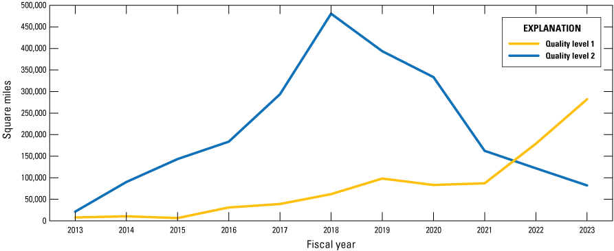
Graph showcasing 10-year trend for 3D Elevation Program (3DEP) light detection and ranging (lidar) data collection quality. The area collected with quality level (QL) 2 topographic lidar began to decline in fiscal year 2019, and the area collected at QL1 exceeded QL2 collections in fiscal year (FY) 2022.
Net Present Value
Net present value (NPV) is one metric for evaluating 3DEP scenarios and is the standard criteria for justifying a new program investment on economic principles by the Office of Management and Budget (OMB, 1992). For each program scenario, the NPV was calculated after 10 years where total costs are subtracted from total benefits using discounted values to 2022 dollars. The 3D Nation Study identified significant benefits for topographic lidar, and every scenario evaluated projected high NPVs (NOAA, 2022). Based on NPV, every program scenario considered would be a beneficial investment strategy.
Inland Topobathymetric Lidar Data Collection Strategy
Federal agencies, including the NOAA, U.S. Army Corps of Engineers (USACE), and USGS collect lidar, sonar, image-derived bathymetry, and other remotely sensed data to meet their bathymetric data needs. These same techniques can be used to acquire bathymetry for inland water bodies, depending on the environmental conditions. The USACE Joint Airborne Lidar Bathymetry Technical Center of Expertise (JALBTCX) is leading a community-driven effort to establish a specification for topobathymetric lidar. The USGS Lidar Base specification (U.S. Geological Survey, 2022) for topographic lidar is being used as the starting point for this development effort. The American Society for Photogrammetry and Remote Sensing (ASPRS) established a lidar bathymetry working group led by USACE and USGS staff to help complete the draft specification and to vet it through the ASPRS community. Through the process of validating several pilot topobathymetric lidar datasets, and research on accuracy and performance, the USGS Earth Resources Observation Science (EROS) Center has gained knowledge about the technology that has improved data validation techniques and has refined the collection requirements outlined in USGS task orders for topobathymetric lidar. These efforts are fundamental to developing a more systematic approach to acquiring and managing topobathymetric data.
Requirements for topobathymetric data were identified in the 3D Nation Study (NOAA, 2022) and at Federal inland bathymetry workshops held in 2019 and 2022. The 3D Nation Study identified $860 million in annual benefits for inland bathymetry that could be realized if all needs were met. Considering that the availability of inland topobathymetric data is limited, this is a substantial potential benefit. The 3D Nation Study documented requirements for inland bathymetry on 831 of the 1,352 (61 percent) identified MCAs, as well as a need to integrate bathymetry with topographic lidar collected for uplands to create seamless terrestrial elevation data. The detailed requirements for data types, quality, update frequency, and use are documented in the study report. These requirements are primary drivers for the research, development, and data collection projects for the next generation of 3DEP and 3DHP within the 3DNTM framework.
Inland bathymetry includes data collected on the bottoms of lakes, reservoirs, and rivers, which requires a mix of lidar and sonar, or other emerging technologies, such as image-derived bathymetry. The initial USGS 3DNTM plans for bathymetric mapping will focus mainly on inland rivers. 3DEP is leveraging the program’s experience with lidar technology to map bathymetry using topobathymetric (green laser) lidar. Topobathymetric lidar is most suitable for relatively clear, shallow water bodies with a bright bottom substrate, which are typically rivers in the context of inland water bodies. Mapping the entire river channel bathymetry plus the surrounding riverbanks is challenging, and usually requires a combination of technologies, such as topobathymetric lidar and multibeam sonar data collected from a boat. Lakes and reservoirs are typically mapped with sonar technology because deeper water bodies with dark bottoms are not suitable for topobathymetric lidar. Many rivers in the United States, particularly in the Midwest and eastern regions, are also unsuitable for current topobathymetric lidar technologies due to poor water clarity.
3DEP has been acquiring airborne topobathymetric lidar for inland river pilot projects through the USGS Geospatial Products and Service Contracts (GPSC). This lidar is typically collected to meet QL2 standards described in the Interagency Working Group on Ocean and Coastal Mapping (2018) National Coastal Mapping Strategy. The purpose of the pilot surveys is to test topobathymetric lidar sensors in a variety of rivers with different bottom types, water clarity, and depth to understand sensor performance and to determine what environmental conditions are suitable for the technology. This information can be used in the future to identify inland rivers where topobathymetric lidar would be effective for mapping bathymetry.
The 3DEP topobathymetric elevation data acquisition strategy is driven by the requirements of USGS science and Federal, State, Tribal, and local partners, and where the aquatic environmental conditions are favorable for topobathymetric lidar. As lidar sensors continue to improve and emerging bathymetric mapping technologies become operational, 3DEP aims to continue to evaluate the program plans and, if possible, expand the types and locations of water bodies that are included. Additional partner investments could accelerate the availability of integrated topobathymetric DEMs for the Nation. For example, the NOAA is currently acquiring topobathymetric lidar for several inland rivers to support flood forecasting. The 3DEP plan currently does not include contracting for sonar or acquiring new topobathymetric data for lakes, which are typically mapped by others with boat-based sonar.
Other groups, including USACE, the Bureau of Reclamation, and the USGS Water Mission Area, are mapping selected rivers, lakes, and reservoirs with sonar and other technologies. The USGS 3DNTM aims to play a complementary role by helping to coordinate inland bathymetry mapping efforts among agencies. The 3DNTM plans involve bringing topographic lidar, topobathymetric lidar, sonar, and other bathymetry data sources together to create a continuous elevation surface that maps both terrestrial and submerged topography.
Coastal, nearshore, and offshore bathymetric mapping is led by NOAA’s Office of Coast Survey and National Geodetic Survey Remote Sensing Division and through the USACE JALBTCX. The JALBTCX National Coastal Mapping Program maps the coast of the United States (including the Great Lakes) on a recurring basis. These agencies work together to acquire and publish topographic and bathymetric elevation data in the coastal zone.
The USGS can leverage the work of the other agencies and contribute to the advancement of an inland topobathymetric component of 3DEP by
-
• Providing program coordination between the producers and users of inland bathymetry and leading the effort to unify interagency goals, specifications, and best practices to reduce costs, avoid redundancy, and create multiuse authoritative datasets.
-
• Supporting and leveraging inland bathymetry lidar acquisition partnerships to extend coverage.
-
• Producing integrated topobathymetric DEMs.
-
• Making other data available by connecting externally owned data repositories through the 3D Nation Ecosystem.
The USGS NGP aims to expand development in the four areas as outlined above and intends to assess the next steps for moving toward a more systematic national approach to acquire and facilitate inland bathymetry data. During the first 5 years, 3DEP will likely focus on coordinating with other Federal agencies to identify and access source data, developing an operational approach for producing topobathymetric DEMs, and determining the need for additional products such as bankfull or top of bank, depth, and thalweg.
3D Nation Ecosystem—Access to Community-Wide Data
3DEP data and products created from standardized topographic lidar and IfSAR data collections are currently (2025) managed within a single nationwide data repository managed by the USGS. In the next generation of the program, 3DEP would retain a partnership approach to collect authoritative data but would expand its facilitation and coordination role to integrate additional data resources under a federated big data governance model to support broader needs for 3D information. A new 3D Nation Ecosystem, in cooperation with NOAA as part of the 3D Nation concept and in partnership with other Federal agencies (fig. 5), could expand access to a broad range of partner data and information services allowing for a more flexible approach to meeting user needs. For example, direct data contributions and sharing of tools and software code among the 3DEP Working Group (refer to governance below) members would enable users to turn data into information and to compare and use datasets interchangeably. The 3D Nation Ecosystem concept would be more fully defined through the research program with an overarching goal to reduce duplication and make more elevation data readily available by connecting to other non-authoritative dataset resources. It is anticipated that the 3D Nation Ecosystem will initially be released as a small set of data (such as connecting to NOAA Digital Coast) and may expand over time with the goal to include data from States, Tribal, and other organizations.
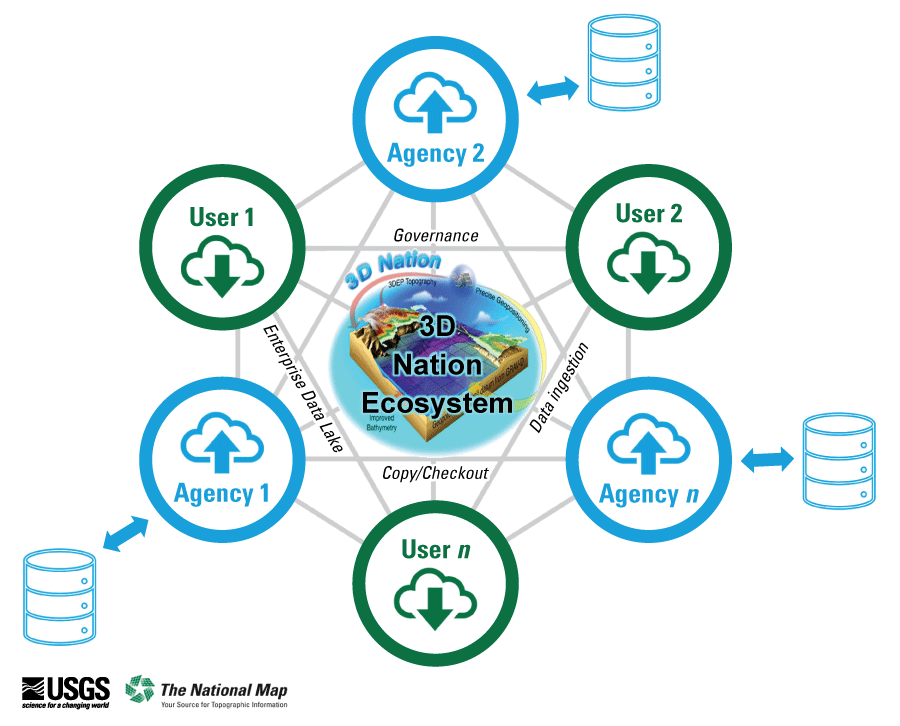
Visualized concept of 3D Nation Ecosystem where large datasets from partner organizations may be combined with 3D Elevation Program (3DEP) data to perform large area analyses. Abbreviations: GRAV-D, Gravity for the Redefinition of the American Vertical Datum; n, number.
Next-Generation 3DEP Research and Development Agenda
The next generation of 3DEP includes program objectives that require new data specifications, improved production throughput, and advanced capability to meet user needs. Each of the 10 research activities identified below is designed to produce an outcome that directly supports these 3DEP requirements. A detailed research plan is under development to address these needs. The research activities may be led by multiple USGS programs or by another partner Federal agency. Partnerships with the private sector, Tribes, universities, and States could advance key elements of the research agenda. Generally, the work will likely be coordinated by the USGS NGP unless another Federal agency is leading the effort. The 3DEP research objectives, which often include multiple components, include the following:
-
• Reduce data validation and publication elapsed times and increase production throughput. Use of private sector production capacity to address this need would be evaluated.
-
• Develop a seamless 1-meter bare-earth DEM product created from a compilation of topographic lidar projects that are hydroflattened using breaklines for the best approximation of water levels.
-
• Develop an integrated imagery and elevation data product.
-
• Develop core capabilities of the 3D Nation Ecosystem and provide iterative improvements over time to expand the network of providers and users.
-
• Develop methodology for using change detection to inform new data collection priorities and to quantify 3D change over time.
-
• Develop procedures needed to support 3D accuracy testing and reporting.
-
• Monitor and assess various technologies to identify improved and lower cost data acquisition solutions, including concurrent lidar-imagery acquisitions.
-
• Evaluate systems and develop methods and specifications for collecting and integrating inland bathymetry for a seamless topobathymetric DEM product. A bare-earth surface DEM contains seamless elevation information for every pixel on the Earth's surface, above and below water. It would be derived from topographic lidar, topobathymetric lidar, and acoustic sonar data, and would contain breaklines delineating the extents of the various sensor modalities used.
-
• Develop a national tiling scheme and specifications for managing and sharing elevation data.
-
• Develop capabilities to create products and enable processing of extremely large areas needed to support data management and large area analysis by users.
Most of the research activities have been initiated and may be periodically reviewed and refined as the next generation of 3DEP is implemented. Research will include continuous evaluations of new technologies and offer recommendations for operational changes. These may involve authoritative data streams or connected resources via the 3D Nation Ecosystem. Timelines (fig. 6) exist for each of the research actions that coincide with program deliverables planned through year 5 of the next generation of 3DEP.
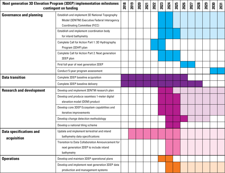
Graph showing next-generation 3D Elevation Program implementation milestones. Dark tones indicate development activities and lighter tones represent ongoing or operational program activities. Abbreviations: 3D, three dimensional; 3DEP, 3D Elevation Program; 3DHP, 3D Hydrography Program; 3DNTM, 3D National Topography Model; DEM, digital elevation model; FICC, Federal Interagency Coordinating Committee; FY, fiscal year.
Governance—An Evolving Model
The past 3DEP governance led by the interagency 3DEP Executive Forum was successful in building partnerships and funding to advance the baseline goal for national lidar coverage (IfSAR in Alaska) through the commitment of key Federal agencies. The NLPA enacted in 2021 established the 3DE-FICC led by the U.S. Department of the Interior (DOI), which has replaced the 3DEP Executive Forum. By codifying the governance into law, the NLPA provides an opportunity to increase the number of agencies engaging with the program. The 3DE-FICC has been established and is being chaired by the DOI Assistant Secretary for Water and Science.
The NLPA directs the 3DE-FICC to coordinate 3D elevation data management across the Federal government, to develop and periodically update a strategic plan that establishes goals and priorities for 3DEP, and to establish a detailed management plan to implement the strategic plan. The law further established a 3DEP subcommittee under the Federal Geographic Data Committee and the National Geospatial Advisory Committee to provide a 3DEP assessment and recommendations to the 3DE-FICC. The subcommittee represents non-federal interests, and by statute, includes representatives of research and academic institutions, industry standards development organizations, units of State and local government, and the private sector. The subcommittee was established in August 2022 to include all the sectors required by NPLA with the addition of Tribal representation. The subcommittee completed its assessment in July 2023.
Composed of 13 Federal agencies and representatives from the American Association of State Geologists (AASG) and the National States Geographic Information Council (NSGIC), the 3DEP Working Group is the operational coordination body for terrestrial elevation. It reports to the newly formed 3DE-FICC. State coordination through NSGIC and AASG is planned to continue to reside with the 3DEP Working Group and through ongoing USGS collaboration with NSGIC. The 3DEP Working Group is responsible for developing, promoting, and executing a national strategy for acquisition, management, and distribution of elevation data consistent with the goals of 3DEP. This includes monitoring elevation and geospatial technology developments that may affect 3DEP and supporting the adoption and application of new technologies for the program. The National Map liaison network helps to further facilitate communications with partner and user communities (https://www.usgs.gov/ngp-user-engagement-office/).
Federal Roles and Responsibilities
The ongoing success of 3DEP depends on the active support of Federal agencies to fulfill the following roles and responsibilities:
-
• Coordinating and facilitating development of annual and multiyear plans for their agencies nationally.
-
• Providing spokespeople and supporting the goals of the next generation of the program.
-
• Becoming members of and participating in the interagency 3DE-FICC planning activities.
-
• Working in partnership and providing financial contributions to data acquisition projects or acquiring and contributing data that meet 3DEP specifications.
State Roles and Responsibilities
The States are major partners and often lead statewide acquisition programs. The 3DEP planning approach is intended to encourage the expansion of state-level partnerships. State roles and structures continue to vary across the country. It is incumbent upon the Federal agencies to recognize this and accommodate the variation that exists. Characteristics of successful State partnerships include the following elements:
-
• A statewide funding strategy to collect and manage 3D elevation data and funding to participate in partnership activities.
-
• An outreach strategy to support the goals of the next generation of the program.
-
• A program to coordinate and facilitate the development of local and regional partnerships.
-
• A commitment to meet or exceed 3DEP data acquisition specifications.
The 3DEP partnership approach addresses findings in the U.S. Government Accountability Office’s report GAO–13–94 on geospatial information coordination and reducing duplication (U.S. Government Accountability Office, 2012) and fulfills OMB’s requirements (Office of Management and Budget, 2013) for managing National Geospatial Data Assets through a unified and well-communicated process of coordination and partnerships.
-
As outlined, the 3DEP data acquisition partnership approach could be beneficial in the following ways:
-
• The level of investments may remain high or increase, improving cost efficiency of acquisition and providing a greater return on individual agency investments in terms of data coverage and quality.
-
• Economic benefits directly attributable to high-quality 3D elevation data could be greater and realized sooner than if USGS does not partner with States.
-
• Multiyear Federal plans would provide advance notice of potential partnerships to help States prepare budget initiatives and participate fully in 3DEP.
-
• Common and standard data collection specifications, if implemented, could ensure that data are compatible and support geographic analyses across State lines and project boundaries.
-
• The USGS GPSC is designed to provide the most consistent and efficient contract mechanism to contribute 3D elevation data to the national collection.
-
• Large-area data acquisition projects are generally expected to be consistent with most State plans that have called for statewide coverage.
-
• The patchwork-quilt effect could be minimized through larger area data collection projects, which accelerate the rate of coverage.
-
• The higher QL1 data acquisition specification under 3DEP could provide for a lower cost upgrade path for States or other partners that want QL0 data.
Tribal Coordination
All Federally recognized Tribes would be notified about the next generation of 3DEP and invited to participate in the program. USGS has determined that the acquisition and publication of airborne lidar for Tribal lands requires Tribal notification to comply with the DOI Tribal consultation policy. USGS notifies Tribes before acquiring and publishing lidar data, and upon request, restricts public access to elevation data products for Tribal lands to respect the data sovereignty and privacy of Tribes. The restricted data are provided to the Tribe for their use if requested.
For lidar data collection efforts, Tribes are encouraged to submit proposals for matching Federal funding through the annual 3DEP Data Collaboration Announcement (DCA). The USGS has funded proposals led by Tribes over the years. The NGP network of National Map Liaisons can assist Tribes with questions about lidar data. The liaisons also attend meetings and conferences hosted by intertribal organizations to share information about 3DEP and other USGS programs and to build relationships with Tribes. Tribes are encouraged to reach out to their liaison to learn more about how to engage with the program.
Funding
3DEP was envisioned as a major data collection effort that would rely heavily on partners working together to fund data acquisition. This model has been highly successful. In addition to funding operations, including managing governance, partnerships, data acquisition and processing, and delivery of 3DEP products and services, the USGS funded 21 percent (while partners [including special appropriations] funded 79 percent) of the total data acquisition cost in fiscal years 2015 to 2023 (fig. 7) to collect data for the Nation (total funding, including program management, is shown in figure 8). Partners funded about 62% of the overall costs of the program. Substantial funding was provided by three Federal agencies—Natural Resources Conservation Service, Federal Emergency Management Agency (FEMA), and the USGS—and by States that participated in data collection projects. More than 350 Federal, State, and other partners have made contributions to 3DEP. In addition to partnership contributions, special appropriations such as supplemental funding for disasters have provided substantial support to data acquisition and operations.

Chart displaying 3D Elevation Program (3DEP) acquisition funding by Federal agencies and non-Federal sources for fiscal years 2015–2023. Supplemental appropriations include disaster supplementals, bipartisan infrastructure law funding through the U.S. Geological Survey’s Earth Mapping Resources Initiative (Earth MRI) program, and Inflation Reduction Act funding for 3DEP. Abbreviations: ARS, Agricultural Research Service; BIA, Bureau of Indian Affairs; BLM, Bureau of Land Management; BOR, Bureau of Reclamation; CBP, U.S. Customs and Border Protection; DOE, U.S. Department of Energy; FEMA, Federal Emergency Management Agency; FWS, U.S. Fish and Wildlife Service; IJC, International Joint Commission; NOAA, National Oceanic and Atmospheric Administration; NPS, National Park Service; NRCS, Natural Resources Conservation Service; OSMRE, Office of Surface Mining Reclamation and Enforcement; TVA, Tennessee Valley Authority; USACE, U.S. Army Corps of Engineers; USFS, U.S. Forest Service; %, percent.
Funding for 3DEP increased each fiscal year from 2015 to 2019 (fig. 8). These funding increases occurred as the program experienced early successes and partner investments grew. Initially, funding from USGS and partner agencies targeted the high-priority areas in the United States. As the program progressed, the remaining lower priority areas without coverage had fewer partnership opportunities, and funding began to decline. The funding declines can, in part, be attributed to Federal and State budget reductions during the COVID-19 pandemic. Although funding has been limited, the areas yet to be collected have significant benefit potential, particularly related to natural resource management, environmental assessments, and energy development. However, requirements and potential benefits do not always translate into funding for lidar when those activities support programs outside of the existing partnership circle. With a mission to provide consistent nationwide data for all areas, including socioeconomically vulnerable communities, the USGS will strive to expand partnership development efforts to attract other Federal and State agencies, NGOs, Tribal, and private sector partnerships in geographies where historical funding has been lacking.
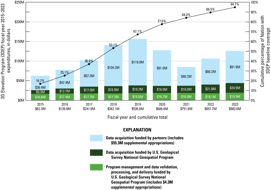
Graphs depicting historical 3D Elevation Program (3DEP) expenditures by major funding group. The bar graph shows the yearly 3DEP costs allocated to program management, data acquisition (partners), and data acquisition (USGS). The line graph shows the accumulated data collection by percentage of the United States and its territories. Abbreviations: M, millions; NGP, National Geospatial Program; USGS, U.S. Geological Survey
Next-Generation 3DEP Funding Strategy
The next generation of 3DEP is designed to support the high-priority needs identified in the 3D Nation Study. The need to collect higher quality data on a 5-year collection cycle has a projected cost that is about 2.4 times the baseline data collection program. Like the original 3DEP Call for Action (Sugarbaker and others, 2014), it is assumed that funding growth will be incremental (fig. 9) until a level necessary to sustain the new data collection rates is achieved. Next-generation 3DEP planning assumes a continuing program where new collection cycles are initiated every 5 years to support business applications or repeat data collections are needed to assess change. This overall change in strategy and program scope requires that partnership investments increase to cover the projected cost. The community response to the next-generation 3DEP plan could directly affect the size and nature of the program moving forward.

Chart illustrating the cost projection for the next generation of the 3D Elevation Program (3DEP). 3DEP assumes a multiple-year period of program growth during the transition years and early years of full production. As with baseline 3DEP data acquisitions, ongoing partnership contributions may be substantial. Transition year 1 (T1) through transition year 3 (T3) represents the transition years from completing baseline 3DEP data collection and management and startup for the next generation of 3DEP. Abbreviations: M, millions.
The funding needs for the next generation of 3DEP may require new partnerships and increased commitments from the USGS and partner organizations. Federal programs and new legislation, such as the next generation of flood hazard and risk information from FEMA, the NOAA National Water Model (National Oceanic and Atmospheric Administration, 2016), NLPA, Inflation Reduction Act, USGS Earth Mapping Resources Initiative (Earth MRI), USDA Farm Production and Conservation Business Center (FPAC), USFS Geospatial Technology and Applications Center (GTAC) and various disaster recovery funds have made substantial contributions to 3DEP. States and Tribes have participated in 3DEP by jointly funding projects or directly contributing elevation data. 3DEP could continue to rely on these funding sources to meet future program needs.
The USGS, with assistance from partner organizations, will likely expand the education and outreach activities to reach new communities of interest. These may include the non-profit sectors (including charitable trusts), education research communities, private sectors, and other government institutions. Although the 3D Nation Study reached a broad community of users, new potential uses may emerge over the next few years. An outreach strategy will seek to reach these new data consumer communities. While the current USGS National Map liaison network may be a critical part of this strategy, additional resources and approaches may be needed to identify and reach new potential partners. A market research and outreach activity could assess new opportunities in the government, private, Tribal, and NGO communities and develop a strategy for engaging key organizations. New funding could be expanded into less traditional areas, such as broadband, precision agriculture, oil and gas, transportation, development, medical research, social services, and others.
Next-Generation 3DEP—The Path Ahead
3DEP provides a national baseline of consistent, high-quality data that could continue to grow in value as it is used for comparison with new 3DEP data collections. 3DEP QL2 (or better) baseline data are available or in progress for about 98.3 percent of the Nation at the end of fiscal year 2024. A map of the current 3DEP lidar point cloud and DEM data that is published and available through several avenues, such as direct file transfer protocol (FTP) download and cloud access, is viewable in the 3DEP Lidar Explorer (https://apps.nationalmap.gov/lidar-explorer) and through The National Map (https://usgs.gov/nationalmap). The USGS continues to prioritize the acquisition of 3DEP baseline data to complete national data coverage and is in transition to the next-generation data that are being collected in areas with existing data that are 5 or more years old. In the remaining areas where the baseline is being completed, the USGS plans to continue to participate at the QL2 level with partners funding QL1 upgrades, if desired. The USGS would become full QL1 project participants for areas that are being recollected under the next-generation 3DEP acquisition plans. The USGS aims to continue to accept and publish data produced by others that meet the 3DEP specifications.
The USGS is drawing on the 3D Nation Study, 3DEP experience, and stakeholder feedback to design the next generation of the program (fig. 6) to provide increased QLs and refresh rates with more flexibility to meet changing user needs. Although the 3DEP baseline goal was intended to complete topographic lidar and DEM coverage that is nationally consistent within a set timeframe, a more flexible next generation of 3DEP will aim to adjust to changing user needs. USGS data product offerings, for example, could be enhanced by a 3D Nation Ecosystem infrastructure that provides user access to data and services from other organizations. It is the intent of the program to reassess the program design in 5 years when it is anticipated the research and development efforts could influence changes to the program design.
The transition to the next-generation 3DEP data collection activities includes substantial operations development in 3DEP and within the 3DHP production environments. Under the umbrella of the 3DNTM, operations would integrate components of both 3DEP and 3DHP production. The result would be synchronized data that more directly support scientific analysis and customer needs. Standard elevation products and services are a cornerstone of 3DEP. These product and service offerings are being expanded under the next generation of 3DEP, pending research outcomes, to include a seamless 1-meter bare-earth DEM and a seamless topobathymetric DEM. The 3D Nation Ecosystem represents a notable step to offering a service that links to elevation data products from other organizations.
The USGS National Geospatial Directorate, which provides operational support to NGP, initiated production operations planning in fiscal year 2024 for the next generation of 3DEP. The plan will likely include continued baseline data, product, and services management, 3D Nation Ecosystem services, and acquisition, including validation and product generation. It is assumed the plan will be updated annually to adjust to partner needs throughout the next generation of 3DEP. The research activities include integrated 3DNTM production systems, noteworthy goals to reduce lidar acquisition to publication times, and the addition of new products and services that could affect operations. Additionally, operational efficiency improvements and expanded data storage could be needed to compensate for the added costs associated with the higher data density of predominantly QL1 data collections. The data life cycle management costs in this next-generation 3DEP Call for Action have been projected for future years as a percentage of acquisition cost and may be refined in the operations plan.
Risk Management and 5-year Program Assessment
The next generation of 3DEP is an ambitious effort to increase data acquisition quality levels, collect data more frequently, shorten the production timeline, expand data collection to include topobathymetric lidar, and expand service offerings. The overall program management approach to provide a forum for quickly recognizing a changing technology landscape and new customer requirements could enable stability and short-term success. As in the past, the program would be managed for continuous improvement. However, a more comprehensive assessment of the program and progress toward these goals could occur about 5 years after the next generation of 3DEP is initiated. At 5 years, the research and development efforts in the areas of change detection methodologies, integrated topobathymetric and topographic data products, new data collection systems, and the 3D Nation Ecosystem are expected to provide insights on how to further advance the 3DEP. The 5-year assessment could provide a more formal program evaluation and substantial adjustments to the long-term goals.
The known program risks have been documented, and strategies have been developed to minimize risk exposure or to have a plan of action when risk cannot be mitigated. The management strategy, as outlined above, allows for the inevitable adjustments to counter these risks. Known risks associated with the 3DEP expansion include the following:
-
• Insufficient funding results in gaps and areas with lower quality or older data. Partnership development in some areas has been difficult and is likely to be a future challenge.
-
• Insufficient funding substantially increases the timeframe to achieve national coverage, preventing the 5-year collection cycle goal from being achieved.
-
• Funds are not allocated to the development of information management or technology infrastructure to meet growing needs. As 3DEP baseline data are completed and higher density QL1 lidar are collected more frequently, the cost of data management and storage could increase substantially.
-
• Products or services are delayed due to weather, validation, and publication staff resource or technology limitations. The timeframe of 18–24 months from collection to publishing data warrants reduction for a program where 5-year collection cycles are planned.
-
• Inland bathymetric data collection systems and processes are at a low maturity level and data acquisition is costly. Advancing to a systematic national approach could be difficult. Engaging users and the bathymetric data collection community to be part of 3DEP may be challenging.
-
• Research funding may be limited, and the timeframe from research to operations may be optimistic.
-
• 3D Nation Ecosystem has dependencies outside of USGS control, including rules on data sharing, privacy, network accessibility, and evolving cloud services. Participation by others may be limited.
The core 3DEP strategies to manage these risks include the following:
-
• Strategy 1: The 3DE-FICC, including partner organizations, would participate in the decision-making process, ensuring that priorities and issue resolution are achieved by consensus.
-
• Strategy 2: The next generation 3DEP is designed and can be executed to scale to any funding level.
-
• Strategy 3: An outreach strategy is planned to be developed to address funding challenges that are unique to parts of the country, such as the arid Southwest, agricultural, and coastal areas. The USGS may leverage the NGAC 3DEP subcommittee to advance and implement the strategy across all sectors.
-
• Strategy 4: 3DEP partnerships are designed to meet and build on the needs of the contributing agencies. Participation in the 3DEP initiative is voluntary, reducing risk exposure to any agency’s mission critical activities.
-
• Strategy 5: To the extent possible, data editing, review, and product generation would be sourced to private sector providers. Data editing, checking, and validation routines would be widely shared with the data collection community to encourage consistency and reduce correction cycles.
-
• Strategy 6: Systems development can be managed into small, low-risk projects with actionable technology solutions at the conclusion of each phase.
-
• Strategy 7: Information technology investments may be minimized and flexible by using cloud services and taking advantage of lease options when technology or services are acquired.
Summary
The next generation of the 3D Elevation Program (3DEP) is ambitious and similar in magnitude to the original 3DEP data collection goal. As with the 3DEP baseline, the next generation of the program requires community-wide support. The degree to which the community requirements documented in the 3D Nation Study will be supported through increased investment cannot be predicted. The U.S. Geological Survey (USGS) plans to evaluate the progress annually and assess the funding levels and other program elements in year 5 to determine if major adjustments are necessary.
The key features of the recommended next-generation 3DEP include the following:
-
• A program design that meets 66 percent of the needs documented in the 3D Nation Study, provides an estimated $7.6 billion in annual benefits, and costs $259 million per year if fully funded.
-
• Quality level (QL) 1 or QL2 topographic lidar for the conterminous United States in 5 years, and QL1 or QL2 for Alaska, Hawaii, and U.S. territories in 8 years.
-
• The next generation of 3DEP assumes that recurring updates will continue once a collection cycle is complete.
-
• Focused coordination and development of best practices for inland bathymetry over the next 5 years that will likely lead to a systematic national approach.
-
• Development of the 3D Nation Ecosystem to improve access to multiple-agency elevation data.
-
• A research agenda to advance topobathymetric lidar systems, investigate new technologies, improve lidar-imagery integration, implement three-dimensional (3D) accuracy testing, and utilize change analysis to drive data collection priorities.
-
• A program assessment in 5 years to evaluate partner needs, funding, and new technologies as outlined in the research plan.
The 3DEP national baseline is nearly complete. The 2014 3D Elevation Program Initiative—A Call for Action, was considered by many to be too ambitious. Yet, about 8 years after the first full year of implementation in 2016, nearly all objectives have been met. More than 98 percent of the United States has light detection and ranging (lidar) or interferometric synthetic aperture radar (IfSAR), as specified in the original program. The initial 3DEP baseline data collection will likely be complete by 2026 (contingent on funding) when the last few data collection projects are completed. The total program cost could be slightly less than the original projections. 3DEP continues to work toward completing baseline data collections and began to fund topographic lidar recollects in fiscal year 2023. Research is yielding promising results for the 3D Nation Ecosystem approach to providing access to federated data systems, and topobathymetric lidar data collections are being refined. Specifications for topobathymetric lidar are in process, and seamless digital elevation models (DEMs) that include bathymetry are being created. 3DEP would not have been possible without Federal, State, Tribal, and other partnerships.
Like 3DEP, the next generation of 3DEP may also be considered too ambitious by some, but the need could prove too great not to proceed. Congress recognized this need when it codified the National Landslide Preparedness Act, which sets forth a series of actions as outlined in this plan. A growing economy can be advanced by better planning as the demands on our natural resources continue to grow. High-quality elevation data can inform flood risk management, infrastructure construction, resource management, energy development, agriculture, and a host of other nationally significant applications. Like the original 3DEP goal to establish a terrestrial elevation baseline for the Nation, a new goal to collect higher quality data may only be successful if new partnerships are forged with the private sector, Federal and State agencies, Tribes, and other communities of use.
Acknowledgments
The authors would like to acknowledge the many partners and stakeholders of 3DEP. The completion of the 3DEP baseline high-resolution elevation data coverage would not be possible without their active engagement and investment. The authors would also like to thank the 3DEP Executive Forum and Working Group members and the newly formed 3DE-FICC for their leadership and support of the program. These interagency groups also provided thoughtful feedback on the next generation of 3DEP plan and this report. Working together in partnership has been the theme of the entire program, and it is with a sense of optimism that the authors put forth the plan for the next generation of the program described in this Call to Action. We would also like to thank the private sector mapping firms who collect the 3DEP elevation data on behalf of the U.S. Geological Survey (USGS) and the user community. The authors are grateful to Dewberry for conducting the 3D Nation Study and to the National Oceanic and Atmospheric Administration for co-leading and co-funding the 3D Nation Study. Finally, the program owes a debt of gratitude to Kevin Gallagher, USGS Associate Director for Core Science Systems, now retired, who wore out his shoe leather promoting the program and bringing in new collaborators and supporters since the inception of 3DEP.
References Cited
Anderson, R., Lukas, V., and Aichele, S.S., 2024, The 3D National Topography Model Call for Action—Part 1. The 3D Hydrography Program (ver. 1.1, July 2024): U.S. Geological Survey Circular 1519, 12 p., accessed February 11, 2024, at https://doi.org/10.3133/cir1519.
Dewberry, 2016, National hydrography requirements and benefits study—Preliminary results, May 20, 2016: Fairfax, Va., Dewberry, 139 p. plus appendixes A–O, accessed January 28, 2022, at https://www.dewberry.com/services/geospatial/national-hydrography-requirements-and-benefits-study.
Interagency Working Group on Ocean and Coastal Mapping [IWG-OCM], 2018, National coastal mapping strategy 1.0—Coastal LIDAR elevation for a 3D Nation: IWG-OCM report, 22 p., accessed July 5, 2023, at https://iocm.noaa.gov/about/documents/strategic-plans/IWG-OCM-Final-Coastal-Mapping-Strategy-2018-with-cover.pdf.
National Oceanic and Atmospheric Administration, 2016, National Water Model, accessed July 11, 2023, at https://water.noaa.gov/about/nwm.
National Oceanic and Atmospheric Administration [NOAA], 2022, 3D Nation Elevation Requirements and Benefits Study, accessed June 26, 2023, at https://iocm.noaa.gov/planning/3DNationStudy.html.
Office of Management and Budget [OMB], 1992, Guidelines and discount rates for benefit-cost analysis of Federal programs: Office of Management and Budget Circular A–94, [22 p.], accessed July 5, 2023, at https://obamawhitehouse.archives.gov/sites/default/files/omb/assets/a94/a094.pdf.
Office of Management and Budget, 2002, Coordination of geographic information and related spatial data activities (revised 2002): Office of Management and Budget Circular A–16, accessed February 21, 2024, at https://www.whitehouse.gov/wp-content/uploads/2017/11/Circular-016.pdf.
Office of Management and Budget, 2013, Open data policy—Managing information as an asset: Office of Management and Budget Memorandum M-13-13, accessed February 21, 2024 at https://obamawhitehouse.archives.gov/sites/default/files/omb/memoranda/2013/m-13-13.pdf.
Sugarbaker, L.J., Constance, E.W., Heidemann, H.K., Jason, A.L., Lukas, V., Saghy, D.L., and Stoker, J.M., 2014, The 3D Elevation Program initiative—A call for action: U.S. Geological Survey Circular 1399, 35 p., accessed May 25, 2023, at https://doi.org/10.3133/cir1399.
U.S. Geological Survey, 2022, Lidar Base specification 2022 rev. A (April 6, 2022), in Lidar Base Specification Online: U.S. Geological Survey web page, accessed June 14, 2023, at https://www.usgs.gov/ngp-standards-and-specifications/lidar-base-specification-online.
U.S. Government Accountability Office, 2012, Geospatial information—OMB and agencies need to make coordination a priority to reduce duplication: U.S. Government Accountability Office report GAO–13–94, accessed August 29, 2024, at https://www.gao.gov/assets/gao-13-94.pdf.
Abbreviations
3D
three dimensional
3DE-FICC
3D Elevation Federal Interagency Coordinating Committee
3DEP
3D Elevation Program
3DHP
3D Hydrography Program
3D Nation Study
3D Nation Elevation Requirements and Benefits Study
3DNTM
3D National Topography Model
ASPRS
American Society for Photogrammetry and Remote Sensing
DCA
data collaboration announcement
DEM
digital elevation model
DOI
U.S. Department of the Interior
Earth MRI
Earth Mapping Resources Initiative
EPA
U.S. Environmental Protection Agency
EROS
Earth Resources Observation Science Center (USGS)
FEMA
Federal Emergency Management Agency
FY
fiscal year
GPSC
Geospatial Products and Service Contracts (USGS)
IfSAR
interferometric synthetic aperture radar
JALBTCX
Joint Airborne Lidar Bathymetry Technical Center of Expertise
lidar
light detection and ranging
MCA
mission critical activity
NGO
nongovernmental organization
NGP
National Geospatial Program
NLPA
National Landslide Preparedness Act
NOAA
National Oceanic and Atmospheric Administration
NPS
National Park Service
NPV
net present value
NRCS
Natural Resources Conservation Service
OMB
Office of Management and Budget
OSMSRE
Office of Surface Mining Reclamation and Enforcement
QL
quality level
RMSEz
root mean square error in the z (elevation) dimension
USACE
U.S. Army Corps of Engineers
USGS
U.S. Geological Survey
Disclaimers
Any use of trade, firm, or product names is for descriptive purposes only and does not imply endorsement by the U.S. Government.
Although this information product, for the most part, is in the public domain, it also may contain copyrighted materials as noted in the text. Permission to reproduce copyrighted items must be secured from the copyright owner.
Suggested Citation
Lukas, V., Sugarbaker, L., Thatcher, C., Jason, A., and Stoker, J., 2025, The 3D National Topography Model Call for Action—Part 2: The Next Generation 3D Elevation Program (version 1.1, July 28, 2025): U.S. Geological Survey Circular 1553, 18 p., https://doi.org/10.3133/cir1553.
ISSN: 2330-5703 (online)
Study Area
| Publication type | Report |
|---|---|
| Publication Subtype | USGS Numbered Series |
| Title | The 3D National Topography Model Call for Action—Part 2: The Next Generation 3D Elevation Program |
| Series title | Circular |
| Series number | 1553 |
| DOI | 10.3133/cir1553 |
| Edition | Version 1.0: July 23, 2025; Version 1.1: July 28, 2025 |
| Publication Date | July 23, 2025 |
| Year Published | 2025 |
| Language | English |
| Publisher | U.S. Geological Survey |
| Publisher location | Reston, VA |
| Contributing office(s) | National Geospatial Program |
| Description | Report: vii, 18 p.; 2 Project Sites |
| Country | United States |
| Online Only (Y/N) | Y |
| Additional Online Files (Y/N) | N |