

Engineering and Risk Research—A Strategic Vision for Extending USGS Earthquake Science to Risk Assessment and Mitigation
Links
- Document: Report (12.1 MB pdf) , HTML , XML
- NGMDB Index Page: National Geologic Map Database Index Page (html)
- Download citation as: RIS | Dublin Core
Abstract
As a part of the U.S. Geological Survey (USGS) Natural Hazards Mission Area, the Engineering and Risk Project (ERP) of the Geologic Hazards Science Center conducts civil engineering research to extend natural hazards science to risk assessments. The ERP includes predominantly, but not exclusively, staff funded by the USGS Earthquake Hazards Program. A major focus of the ERP is to deliver actionable information to decisionmakers that helps promote the safety, security, and economic well-being of the Nation. The report discusses briefly the ERP’s evolution and scope, its organization structure, describes key products and deliverables, their efforts to engage with external partners, and its strategy and vision in conducting range of engineering and risk research. The research topics outlined in this report, as developed by the ERP, may be used to facilitate project planning activities during the next 10 years and serve as a longer-term planning resource for the USGS Earthquake Hazards Program and Geologic Hazards Science Center.
Introduction
Earthquake risk reduction efforts within the United States are primarily directed through the National Earthquake Hazards Reduction Program (NEHRP; https://nehrp.gov/) established by the U.S. Congress in its inception through the Earthquake Hazards Reduction Act of 1977 (42 U.S.C. 7704). The National Earthquake Hazards Reduction Program Reauthorization Act of 2018 (Public Law 115–307) provided continued support to four Federal agencies, the National Institute of Standards and Technology (NIST), the Federal Emergency Management Agency (FEMA), the National Science Foundation (NSF), and the U.S. Geological Survey (USGS), to strengthen the country’s preparedness to reduce the risks of life and property from future earthquakes in the United States.
Since the early 1900s, our understanding about earthquakes, their processes, and the hazards and risk posed from shaking and other nonshaking effects on built environment and the communities have evolved with each significant earthquake. Internal and external USGS researchers, including multidisciplinary professionals, have made important strides in studying, explaining, and laying out procedures for tackling current (2025) and envisioning future aspects of earthquake problem towards building seismically resilient communities.
The main research responsibility of the USGS within the NEHRP is to “characterize and identify earthquake hazards, assess earthquake risks, monitor seismic activity, and improve earthquake forecasts” (42 U.S.C. 7704(b)(3)). The USGS Earthquake Hazards Program (EHP) helps to coordinate these efforts by conducting research on causes, characteristics, and effects of earthquakes and by prioritizing research that increases the accuracy and precision of earthquake hazards assessments, forecasts, and monitoring, including producing situational-awareness products for rapid response (Hayes and others, 2024).
According to a 2018 USGS report that defines the role of USGS in risk research and applications, the word “risk” refers to “the potential for consequences where something of value is at stake and where the outcome is uncertain” (Ludwig and others, 2018, p. 51). By contrast, the word “hazard” refers to “a dangerous process, phenomenon, substance, activity or condition that may cause loss of life, injury or other health effects, property damage, loss of livelihoods and services, social and economic disruption, or environmental damage” (Ludwig and others, 2018, p. 51). The phrase “risk assessment” refers to “the qualitative and/or quantitative scientific estimation of risks” (Ludwig and others, 2018, p. 51).
Earthquakes are common across the United States; most activity is focused within the Western United States, Alaska, and Hawaii, but occasional earthquakes are scattered across the Central and Eastern United States (Petersen and others, 2024). The USGS National Seismic Hazard Model (NSHM) team has led the development of state-of-the-art earthquake hazard assessment efforts, which provide long-term forecast of earthquake shaking for various applications, routinely since the 1990s. These NSHM seismic hazard products provide information needed to save lives and property through application in life-safety-based building design codes and codes for developing earthquake resistant criteria for design of highways, bridges, railroads, dams, pipelines, energy systems, and hazardous waste disposal (Petersen and others, 2024).
Earthquake mortality risk in the United States has been substantially reduced because of the stringent life-safety target embedded directly into the building codes complemented by stricter enforcement of codes into design practice, as evidenced from the effects from large earthquakes in last four decades (for example, from 667 deaths per 100,000 people in 1906 from an earthquake in San Francisco, California, to 3.4 deaths per 100,000 in Alameda County, California, during the 1989 Loma Prieta earthquake; Centers for Disease Control and Prevention, 2001). However, the economic risk outlook remains a major cause of concern. Despite the billions of dollars of economic investments in earthquake science and risk-based engineering and design practice for earthquake preparedness, especially in the aftermath of the 1994 Northridge earthquake, the United States is still among the top three nations in the world facing the largest economic risk from earthquakes (Silva and others 2020, p. 19, table 1). A recent study led by FEMA also highlights the economic benefits of adopting hazard-resistant building codes (since 2000) by considering flood, hurricane, wind, and earthquakes (FEMA, 2020a). Of the 1.6 billion dollars of average annual loss avoidance achieved through the adoption of post-2000 building codes, the seismic portion of total loss avoidance is only 60 million. The role of Engineering and Risk Project (ERP) members in this context is critical because the ERP assists in facilitating the adoption of latest earthquake science not only into the building codes for mitigating future risks but by bringing in engineering expertise and leading more directly in estimating, communicating, and assisting towards mitigating seismic risks.
Project Scope
Extending natural hazards science to risk involves (1) conducting research to develop and improve seismic hazard information and associated uncertainties for various building code applications, and (2) assessing seismic risk to the Nation’s buildings and other infrastructure to better communicate with stakeholders and promote seismic safety. The ERP at the USGS Geologic Hazards Science Center (GHSC) is part of the Hazards, Impact, and Risk subcommittee of the Science Coordination Committee of the EHP. This report focuses on engineering research efforts within the scope of this project. Of the three broad areas of work prioritized by the EHP, namely (1) earthquake monitoring, (2) hazard assessments, and (3) targeted research (Hayes and others, 2024), the ERP provides unique expertise to enhance the first two activities and plays a central role in targeted engineering research for earthquake risk reduction. The ERP has the following two main tasks to extend hazard science to engineering risk assessment and risk mitigation through improvements to the U.S. building code regulations for new and existing buildings and other infrastructure by improving the ability of the built environment to resist hazards:
-
• Task 1—Collaborate with external engineers and NSHM project staff on developing earthquake ground motion requirements for building codes. As of 2024, Task 1 has five subtasks:
-
a. Conduct research on earthquake ground motion models for building codes.
-
b. Adopt USGS earthquake hazard assessments into building codes.
-
c. Develop web services and data releases for dissemination of earthquake ground motion models for building codes.
-
d. Simulate, validate, and use earthquake ground motion time series for building codes.
-
e. Develop alternative ground motion intensity measures.
-
-
• Task 2—Extend natural hazard assessments to risk assessments. As of 2024, Task 2 has five subtasks:
-
a. Assess seismic risks to critical infrastructure.
-
b. Forecast earthquake-induced ground failure.
-
c. Create earthquake ground motion and effect scenarios.
-
d. Assess multihazard risks.
-
e. Evaluate the seismic safety of tall buildings and other long-period structures; for example, long-span cable-stayed bridges and power line transmission towers.
-
Both tasks of the project have research and outreach elements. The research and deliverables of the ERP are designed to benefit the following:
-
• Other projects and products within the USGS.
-
• Academic institutions and research organizations across the Nation and around the world.
-
• External engineering practitioners in the seismic design and construction community.
-
• Local, State, and Federal Government agencies.
-
• Insurance, reinsurance, catastrophe-bond issuing companies and consultants.
-
• The private sector community.
-
• The public.
By applying USGS hazard science to the development of seismic loading criteria for building codes and extending the USGS hazard science to risk assessment, the research and development efforts of the ERP (1) more directly connect hazard science with engineering mitigation and risk reduction, and (2) provide feedback from end users on potential improvements to USGS hazard science.
The ERP tasks and subtasks have been designed to collaborate with the internal USGS community (for example, the USGS NSHM Project and the USGS National Earthquake Information Center) to develop requisite data, methods, and tools for assessing risks to building and other infrastructure systems (fig. 1). Risk estimates are developed using hazard, exposure, vulnerability, and consequence models (fig. 1). The hazard model is a probabilistic assessment of the severity of earthquake shaking; the exposure model assesses the engineering characteristics of assets (demographics, buildings, or other infrastructure) that are exposed to the hazard. The vulnerability model assesses the potential damage to assets when subjected to hazards such as earthquake ground shaking. The consequence model assesses the relation between damage and the resulting consequences such as injuries, fatalities, direct economic loss, or indirect economic loss. The goals of the ERP are achieved by collaborating with the external community, for example, the Building Seismic Safety Council (BSSC) and FEMA, to assess seismic loads and help mitigate seismic risk through building codes.
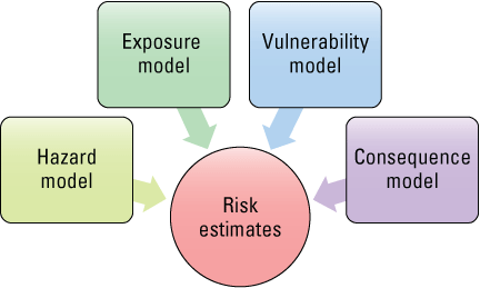
Diagram showing the four key models used to assess risk.
Strategic Priorities
The following are current (2025) key strategic priorities for the ERP:
-
• Improving communication and application of USGS earthquake science for seismic mitigation and risk reduction.
-
• Providing geotechnical and structural engineering expertise to enhance and broaden the use of USGS earthquake science for building code and risk applications.
-
• Developing understanding, methods, and tools to perform quantitative loss and risk modeling of buildings and infrastructure (for example, bridges, pipelines, and dams).
-
• Increasing research capabilities and external collaborations to enhance engineering seismology research.
In addition, the ERP is always interested in developing and improving user-centric tools and interfaces. Such resources include tools for obtaining and developing seismic design parameters for different U.S. building codes, online libraries with information on a range of relevant earthquake scenarios and their effects in conjunction with the NSHM, and an interactive online tool for assessing seismic risk to bridge infrastructure. The ERP is also interested in leveraging community resources to coordinate, collaborate, and accelerate engineering research for mitigating earthquake risk.
The ERP is actively collaborating with internal and external stakeholders to achieve the key strategic priorities. For example, the ERP members serve on various building code committees to facilitate the adoption of NSHM (https://www.usgs.gov/programs/earthquake-hazards/science/national-seismic-hazard-model) into building codes. The ERP team members leverage their structural and geotechnical engineering expertise to conduct and implement cutting-edge collaborative research with the external engineering community that ultimately enhances the seismic design regulations in the United States. Similarly, by actively engaging the NEHRP partner FEMA, the ERP collaborates and codevelops nationwide seismic risk assessments of buildings through FEMA P–366 efforts (Jaiswal and others, 2023). Such research helps to leverage from the latest USGS earthquake science, build upon the latest U.S. Census Bureau Census data, and improve upon mapping of population and building exposures, including their valuation to systematically assess seismic risk.
Research Products and Deliverables
Since the ERP was formed in 2017, the ERP has generated a total of nearly 400 peer-reviewed research products, including 90 journal articles, 20 USGS series products (for example, USGS Open-File Reports), 15 book chapters and cooperator publications, multiple data releases and USGS web pages, and more than 250 abstracts and conference proceedings. The ERP manages several online resources that provide earthquake ground motions for engineering design based on the USGS NSHM (https://earthquake.usgs.gov/hazards/designmaps/) as shown in figure 2. These resources include web services to access seismic design parameters for user-defined locations throughout the United States for U.S. building codes (for example, the American Society of Civil Engineers/Structural Engineering Institute [ASCE/SEI] standard for new buildings [ASCE/SEI. 2022], and the American Association of State Highway and Transportation Officials guide specification for bridge design [American Association of State Highway and Transportation Officials, 2024]). These web resources have been developed and maintained by the ERP through various editions of its guidelines and specifications. The ERP also provides tools for computing risk-targeted ground motions (fig. 3).
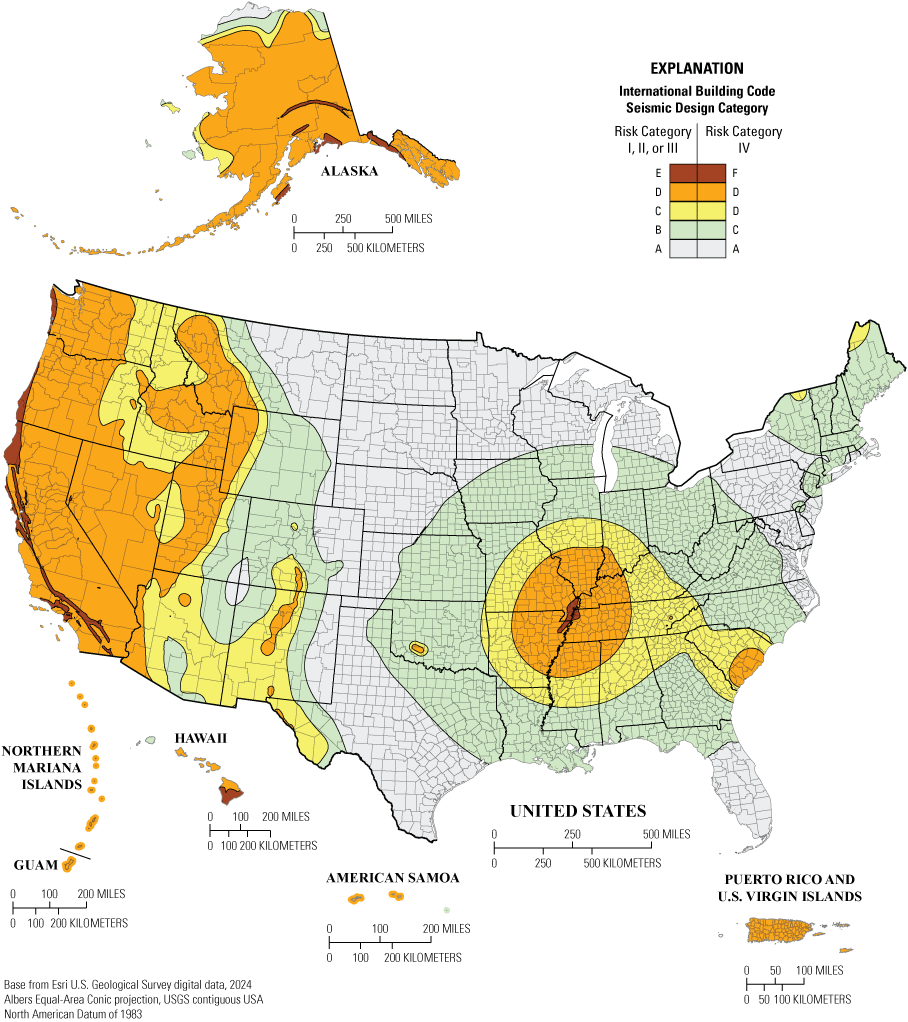
Map of the United States and its territories showing 2024 International Building Code Seismic Design Categories and Risk Categories on the 2020 National Earthquake Hazards Reduction Program recommended seismic provisions (Federal Emergency Management Agency [FEMA] P-2192-4; FEMA, 2020b). The figure shows how specific seismic thresholds are defined by the U.S. Geological Survey (USGS) National Seismic Hazard Model of 2018 (Petersen and others, 2019) and translated into seismic mitigation through the building code efforts and research coordinated through the USGS Engineering and Risk Project. Risk categories (Roman numerals I, II, III, and IV) are defined based on intended usage of the structure and design categories (letters A–D), which are based on location and hazard levels (modified from Petersen and others, 2021).
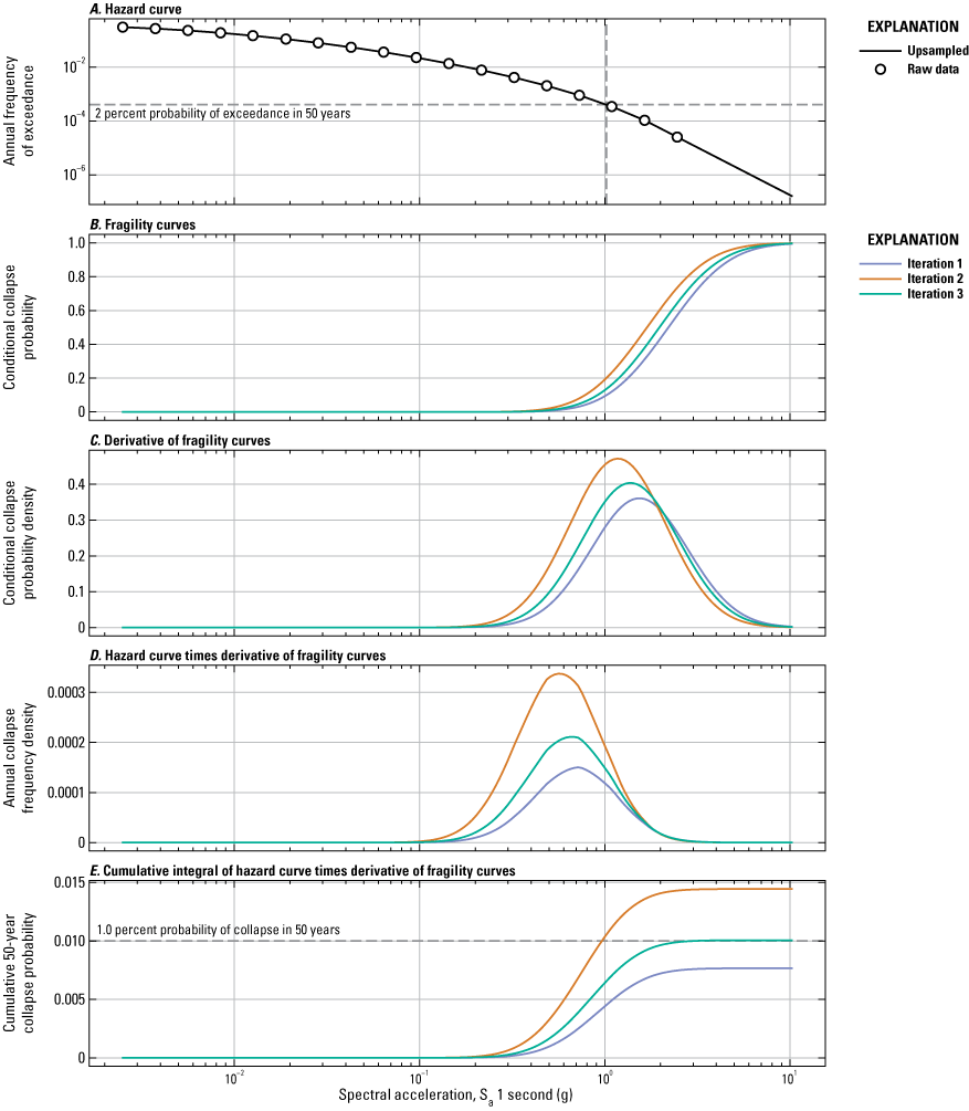
Graphs illustrating the procedure for developing risk-targeted, Maximum Considered Earthquake design parameters A, hazard curve, B, fragility curves, C, derivative of fragility curves, D, hazard curve times derivative of fragility curves, and E, cumulative integral of hazard curve times derivative of fragility curves, in accordance with the American Society of Civil Engineers 7 Hazard Tool guidelines, using the procedures developed in Luco and others (2007) and the U.S. Geological Survey risk-targeted ground motion calculator (Makdisi and others, 2024). The calculator allows the user to estimate risk-targeted ground motion as defined in the building codes for the user-supplied hazard curve inputs (spectral response acceleration values and their corresponding annual frequency of exceedances). Users can perform these calculations using the Python source code or the USGS Earthquake Hazard Toolbox web services (https://earthquake.usgs.gov/ws/nshmp/designmaps/rtgm). g, gravity
In particular, the seismic design web resources provide multiple third-party web graphical user interfaces with access to seismic design parameters (for example, the 2020 NEHRP Recommended Seismic Provisions for New Buildings and Other Structures tool by the National Institute of Building Sciences [https://www.nibs.org/reports/bssc-tool-2020-nehrp-provisions-seismic-design-map-values], American Society of Civil Engineers Hazard Tool [https://ascehazardtool.org], and Structural Engineers Association of California (SEAOC) and California’s Office of Statewide Health Planning and Development (OSHPD) Seismic Design Maps Tool [https://www.seismicmaps.org]. Users from the United States and throughout the world access USGS design motion web services about 3 million times per month by a combination of direct access, third-party graphical user interfaces, and application programming interfaces such as Python or MATLAB (E. Martinez, U.S. Geological Survey, unpub. data, 2024).
Members of the ERP also collaborate with the NSHM and external partners on nationwide seismic risk modeling of buildings (fig. 4) and other infrastructure (fig. 5). They also collaborate with the National Earthquake Information Center on the Prompt Assessment of Global Earthquakes for Response (PAGER) system (https://earthquake.usgs.gov/data/pager/) development efforts. The PAGER system provides near real-time estimates of fatality and economic loss following significant earthquakes anywhere in the world, thereby contributing to risk reduction research and application.
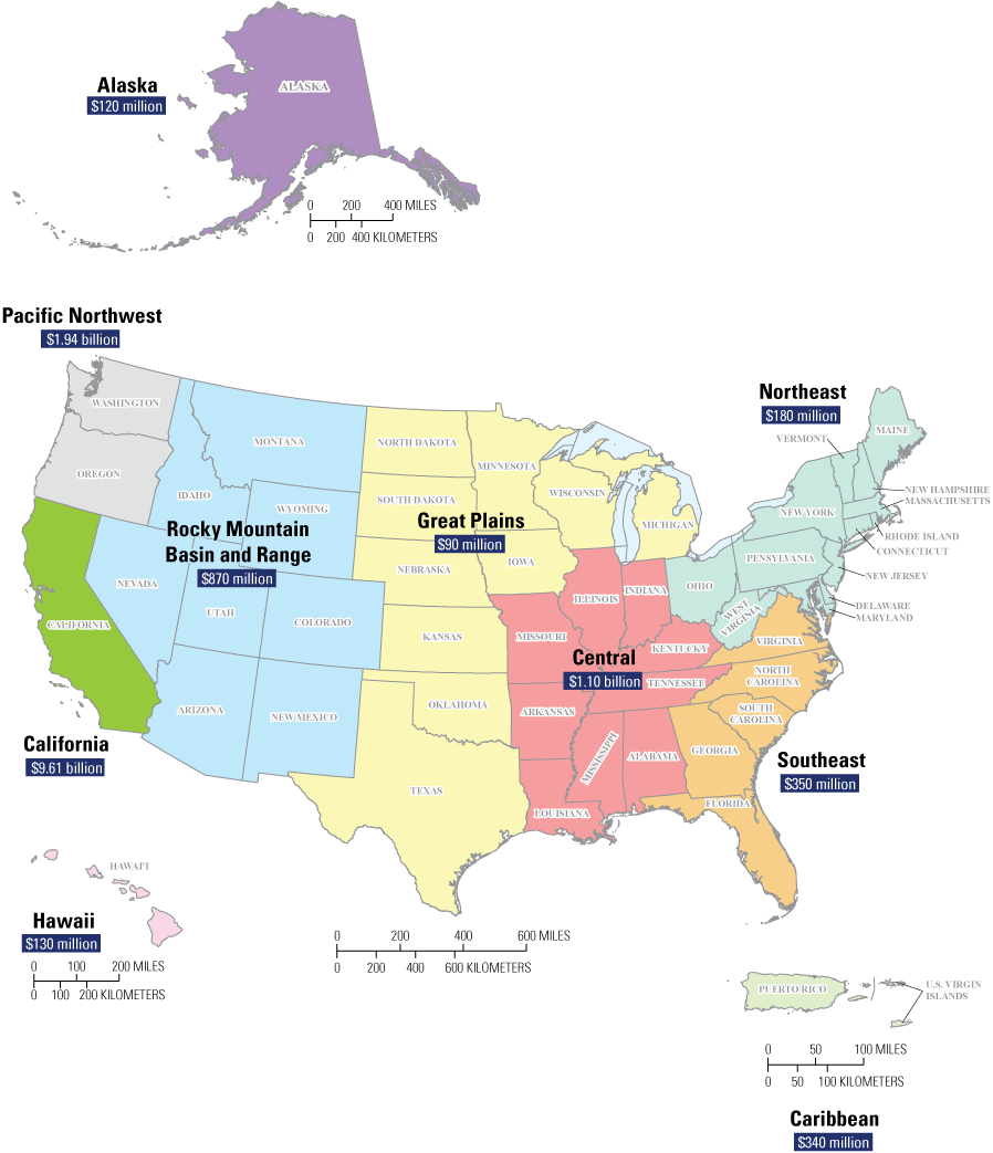
Map of the United States and its territories showing the distribution of average annualized earthquake losses by region (modified from Jaiswal and others, 2023). Economic losses from earthquakes in these nine regions are estimated to average $14.7 billion dollars per year.
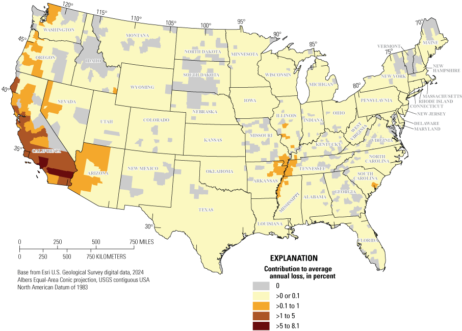
Map of the conterminous United States showing the seismic risk, expressed as contribution to average annual loss, to natural gas transmission pipelines from strong ground shaking (modified from Kwong and others, 2022). >, greater than
External Service and Collaboration
The ERP serves a critical role supporting the NSHM project and contributing to the development of NSHMs in several ways. As one of the first engineering users of NSHM, the ERP provides critical feedback and guidance on developing and implementing new ideas within the NSHM. Additionally, the ERP devotes significant time engaging with the broader practicing engineering and risk research community so that new science gets effectively used and communicated among the wide range of stakeholders. As part of that role, the ERP members serve on numerous external committees and governing bodies to communicate USGS science to various stakeholders and aid in the adoption of NSHM-related engineering design loads into U.S. building codes. For example, ERP members have been a fixture as Federal agency liaisons on the BSSC, which is primarily responsible for updating the NEHRP seismic design provisions on a 5-year cycle. Other standard bodies that the ERP coordinates with and contributes to include the American Association of State Highway and Transportation Officials, American Society of Civil Engineers, and the America Railway Engineering and Maintenance-of-Way Association.
Members of the ERP collaborate internally with geologists, geophysicists, and engineering seismology researchers; computer scientists from the Ground Motion, NSHM, Advanced National Seismic System, Earthquake Geology, and Hazards Development (HazDev) projects at the GHSC; and civil engineering and geophysics researchers from the Shaking, Damage, and Failure project and Pacific Northwest Earthquake Hazards Study project at the USGS Earthquake Science Center (ESC), and the Tsunami and Earthquake Research project at the USGS Pacific Coastal and Marine Science Center. External collaborators include numerous researchers in academia and other government agencies, as well as engineering practitioners from around the United States. The ERP contributes to cross-agency collaborative efforts with Federal agencies and departments, such as:
-
• FEMA, which is the USGS partner for building code-related research and development and has a principal investigative role on development of FEMA P–366—"Hazus Estimated Annualized Earthquake Losses for the United States” (Jaiswal and others, 2023).
-
• The NSF, which notably collaborates with the USGS through joint-funding of the Statewide California Earthquake Center (SCEC), and with which the ERP interacts and coordinates on project and topic-specific focused research.
-
• The U.S. Army Corps of Engineers (Corps), which is primarily focused on seismic risk analysis of dams.
-
• The U.S. Nuclear Regulatory Commission, which collaborates with the ERP on issues related to seismic hazard and risk of nuclear facilities.
-
• The U.S. Agency for International Development, which works on the Training and Communication for Earthquake Risk Assessment project as an associate partner with the Global Earthquake Model Foundation.
-
• The Federal Energy Regulatory Commission (FERC), which works on issues related to soil-fluid-structure interaction of liquefied natural gas terminals subjected to earthquake shaking.
-
• NIST, which evaluates external research grant applications as the subject matter expert and provides NEHRP partner research and development support on assessing seismic hazards and engineering risks and building code maps for use in future design requirements.
Personnel
The ERP team currently (2025) consists of 5 scientific staff, including student interns, who spend their time assisting on ERP-led research. The ERP currently (2025) consists of earthquake engineering researchers with backgrounds in civil, structural, and geotechnical engineering. The ERP also coordinates and conducts non-EHP research on topics covering rockfall hazards (Stock and others, 2014) and work across the USGS Natural Hazards Mission Area evaluating the risk of copper and rhenium supply disruption from global earthquakes (Jaiswal and others, 2024).
Table 1 shows the project tasks and key activities conducted within the ERP by engineering discipline. Members of the ERP have broad expertise in many disciplines, including:
-
• Probabilistic seismic hazard analysis.
-
• Characterization and prediction of strong ground motions.
-
• Performance-based earthquake engineering.
-
• Analysis of seismic risk at site-specific and regional scales.
-
• Simulation, validation, and use of strong ground motion time series for engineering applications.
-
• Selection and modification of ground motion time series for nonlinear analysis of structural and geotechnical systems.
-
• Structural mechanics and nonlinear structural dynamics.
-
• Soil mechanics and nonlinear soil dynamics.
-
• Mechanics of soil liquefaction and liquefaction-induced ground failure.
-
• Simulations of geotechnical systems.
-
• Soil–fluid–structure interaction.
-
• Tsunami hazard and risk analysis.
-
• Postdisaster reconnaissance.
Table 1.
Key activities of the Engineering and Risk Project organized by project tasks and the engineering discipline covering engineering seismology and geotechnical and structural engineering.[Task 1 involves collaboration with external engineers and National Seismic Hazard Model (NSHM) project personnel on earthquake ground motions for building codes. Task 2 involves extending natural hazards to risk. USGS, U.S. Geological Survey]
Research Activities and Growth Opportunities
The research topics outlined in this section, as developed by the ERP, can be used to facilitate project planning activities through the next 10 years and serve as a longer-term planning resource for the EHP and GHSC. These research topics were developed with strong consideration of the critical role the ERP plays in bridging the gap between USGS earthquake science personnel and the external earthquake engineering community, as well as staff expertise, ongoing efforts and collaborations, and unique project strengths. Within the current (2025) fiscal environment, the ERP can reinforce and make incremental improvements to its ongoing research efforts (foundational priorities). However, should additional funding resources become available, the ERP is well-positioned to expand its capabilities to better meet the needs of the public and earthquake engineering communities and the EHP and USGS missions (aspirational priorities).
The ERP long-term research objectives can be organized into five priorities, of which 1, 2, and 3 are foundational and 4 and 5 are aspirational. All five priority areas have significant overlap and coordination:
-
1. Conducting engineering research to facilitate the adoption of the latest USGS science to improve the U.S. seismic design guidelines for engineering practice, in other words, building codes for buildings and other infrastructure systems (structural and geotechnical systems).
-
2. Improving the USGS seismic hazard characterization using, for example, additional spectral periods, site classes, damping ratios, components, and uncertainty characterizations.
-
3. Advancing the assessment of seismic risk at multiple scales for multiple types of infrastructure and communicating such risk assessments to relevant stakeholders.
-
4. Expanding the assessment tools and research on geotechnical earthquake hazards, such as liquefaction-induced ground failure and coseismic landslides.
-
5. Expanding engineering research that contributes to the development and use of earthquake ground motion models (for example, time-series simulations and ground motion model development), and ground failure and structural response models.
Improvements to the U.S. Seismic Design Guidelines (Building Codes)
The ERP currently (2025) plays a critical role as a two-way interface between NSHM products and the earthquake engineering community. The ERP has historically been the primary resource for presenting the NSHM and its periodic updates to practicing engineers. In one direction, the ERP is responsible for clarifying and explaining the advances in the science that underpins the NSHM (for example, changes to the earthquake rupture forecast, ground motion modeling, and characterization of sedimentary basin and coastal plain amplifications) and how those advances affect the resulting design ground motions to the committees that write building codes. In the other direction, the ERP receives feedback from committees on how the NSHM can be updated to enhance engineering practice (for example, more guidance on hazard uncertainties, deterministic earthquake design scenarios, and hazard disaggregation data) and collaborate with NSHM project personnel to assess the feasibility and ultimately deliver such improvements to users. This role is evident in the involvement of ERP personnel as NEHRP agency liaisons to several building code-writing committees, such as BSSC, the American Association of State Highway and Transportation Officials, and others.
Within the context of building codes, ERP researchers have also performed critical research on developing design ground motions and engineered significant improvements to how NSHM hazard data are used in the engineering community (for example, risk-targeted design motions, improvements to site effects, adoption of multiperiod response spectra, and rational incorporation of deterministic earthquakes). These efforts are another example of ERP’s role as a two-way interface between USGS earthquake science and the engineering community. The ERP is keen to continue expanding on this research into the future. Such efforts include the following:
-
• Developing improved seismic design parameters for use in evaluating various geotechnical hazards, such as liquefaction ground failure and coseismic landslides, particularly to address substantial geographic inconsistencies in the acceptable levels of safety against geohazards in typical seismic design guidelines (for example, Makdisi and Kramer, 2024a)
-
• Implementing risk-targeted design motions for performance limit states other than structural collapse (in other words, in service of functional recovery goals for improved community resilience, for example, the FEMA P-2090/NIST SP-1254 report [FEMA, 2021]).
-
• Performing research on methods to improve the selection and modification of ground motion time series for use in nonlinear dynamic analysis of structural and geotechnical systems, and a goal of reducing bias and uncertainty in the probabilistic assessment of various performance limit states; this goal would build on ongoing collaborations with the Corps on seismic risk analysis of dams.
-
• Implementing and adopting improved representation of ground motion hazard uncertainties (for example, report on epistemic uncertainties as discussed in Kwong and Jaiswal [2023]) in building codes.
-
• Researching, in collaboration with the Federal Energy Regulatory Commission, the seismic safety of liquefied natural gas terminals subjected to earthquake shaking.
-
• Developing web tools that interface with the NSHM to help practicing engineers make soil–structure interaction (SSI) computations.
-
• Collaborating internationally with the Global Earthquake Model, supported by the U.S. Departments of State and Defense, to create a web tool that provides seismic hazard data and building code values for a user-specified location in any country covered by the Global Seismic Hazard Model.
Improvements to the U.S. Geological Survey Seismic Hazard Characterization
One of the flagship USGS earthquake science products is the NSHM, which provides valuable information to users on the levels of expected ground shaking from a variety of seismic sources across the United States. Although knowledge of ground shaking hazards is a crucial starting point in understanding how earthquakes may affect human populations, one of the most important uses of the NSHM comes from how it is translated into more actionable information to stakeholders, and, just as importantly, how the NSHM can be improved to enhance its utility for risk-based applications.
To that end, the ERP continues to be well-positioned to use internal and external research, as well as interactions with stakeholders, to facilitate collaboration with the NSHM project to improve its utility as a tool in risk assessment and mitigation. Such ongoing and future efforts include the following:
-
• Establishing a working group on using ground motion data from physics-informed and other broadband earthquake simulations to inform components of the NSHM. The Ground Motion Simulation Validation group is an ongoing effort through the SCEC and includes collaborations with USGS Ground Motion Project personnel and external partners.
-
• Implementing improved and alternative representations of ground shaking in the NSHM for future use in building codes and risk assessment. Examples include alternative intensity measures (for example, energy-based metrics, such as Arias intensity (AI), which represents the time integral of square of ground accelerations, and cumulative absolute velocity (CAV) which is defined as integral of the absolute value of an acceleration time series, and metrics based on nonlinear or inelastic single degree of freedom system response), response spectral accelerations at various damping levels, vertical ground motion components, and improved long-period characterization.
-
• Providing engineering input to the NSHM working group on uncertainties, which is aimed at better incorporating and communicating ground motion hazard uncertainties in NSHM results to users. The long-term goal is to provide users with NSHM mean hazard curve data with some representation of the uncertainty (for example, fractiles and standard deviation), and to facilitate the incorporation of such uncertainties in building codes, insurance models, and a variety of loss and risk modeling applications.
-
• Developing a unified and publicly available database of ground motion time series for use in engineering design and research with cross-agency coordination and support with, for example, the Corps, the U.S. Department of Transportation Federal Highway Administration, and NIST. This effort would also involve coordination with USGS Ground Motion Project, Advanced National Seismic System Project, HazDev, and other USGS EHP personnel. The goal of such an effort would be to streamline ground motion data processing, data management practices, and public availability in a way that reflects the wide range of internal USGS research uses for ground motion data and enhances external user (for example, Federal and State agency partners, practicing engineers, and academic researcher) access to ground motion data for improved earthquake engineering analysis and design.
Risk Assessment
Among the four agencies within the NEHRP, the USGS is the only agency with the stated responsibility of researching and assessing earthquake risks (42 U.S.C. 7704(b)(3)). To assist the USGS with this responsibility, the ERP provides engineering expertise and direct leadership in the estimation and communication of seismic risks. Ensuring that estimated risk information is actionable for decisionmakers and stakeholders requires appropriate communication of risks and the associated uncertainties. Equally important, feedback from stakeholders enhances the quality of the hazard science and subsequent risk assessments.
In addition to figure 1, the distinction between hazard and risk is further illustrated in figure 5. The figure shows the seismic risk to natural gas transmission pipelines in the conterminous United States. The map in figure 5 was originally developed by Kwong and others (2022) by combining the 2018 USGS NSHM map, a logic tree-based exposure model, three different vulnerability models, and a consequence model. Seismic risk is expressed using the average annual cost required to repair pipelines that may be damaged from strong ground shaking alone and, hence, can be interpreted as a lower bound of the actual risk. The dark regions for example, from California, parts of Oregon, Washington, Arizona, and others indicate counties that carry high risk, relative to other counties (fig. 5). Comparing the geospatial distribution of risk against that of hazard demonstrates that two different geographic regions with differing hazard can carry similar levels of seismic risk. For example, although the earthquake hazard in Arizona is less than that in Washington (Petersen and others, 2024), the seismic risk to natural gas transmission pipelines in both States are within a similar order of magnitude. Such discrepancies between hazard and risk arise from differences in exposure (for example, total mileage of pipelines), vulnerability (for example, likelihood of seismic damage), and consequence (for example, costs required to repair a leak). Therefore, changes in seismic risk between USGS NSHM update cycles are not necessarily commensurate with changes in hazard.
To reduce adverse effects of earthquakes on the built environment, seismic risk needs to be assessed routinely and systematically. The ERP has been an integral part of assessing risks for many ongoing projects. For example, the ERP assists, maintains, or enhances many of the USGS products (for example, NSHM, PAGER, and ShakeCast [https://www.usgs.gov/publications/earthquakes-shakecast/]). Ongoing projects and examples of actions taken include the following:
-
• Long-term risk assessments at localized geospatial scales (for example, ground motion selection for engineered systems that are sensitive to the vertical components of ground motion, and collaboration with the Corps in developing resources for selecting ground motion time histories to assess seismic risk of dams).
-
• Long-term risk assessments at national scales (for example, collaboration with FEMA on seismic risk assessments of buildings using different versions of the USGS NSHM, collaboration with the U.S. Department of Transportation on seismic risk assessments of bridges as described in Kortum [2021], or pipelines).
-
• Integration of engineering and risk assessment expertise and postearthquake information products for monitoring and response purposes (for example, the USGS ShakeMap, PAGER, and ShakeCast systems).
-
• Collaboration with the National Park Service on rockfall hazards (for example, as described in Stock and others [2014]).
-
• Collaboration with the USGS National Minerals Information Center on assessment of the disruption potential of global earthquakes on the U.S. supply chain for copper and other mineral commodities (for example, as described in Jaiswal and others [2024]).
-
• Communication of risks to ensure delivered information is actionable by external stakeholders (for example, developing earthquake rupture scenarios that are consistent with the 2023 NSHM, as described in Chase and others [2024] and illustrated in figure 6, which explores potential implications of modeling an earthquake scenario with a shallow rupture and its implication on likely shaking and earthquake losses in various U.S. Census Bureau Census tract and counties in the region).
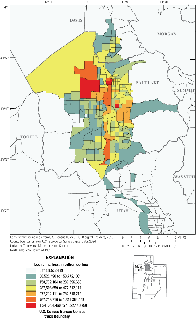
Map of the Salt Lake City, Utah, area showing the distribution of the estimated $75 billion in economic losses throughout the affected U.S. Census Bureau Census tract and counties that could result from a magnitude 7.1 earthquake (modified from Chase and others, 2024). The scenario loss estimates were developed using the Federal Emergency Management Agency (FEMA) Hazus Multi-Hazard (Hazus-MH) 6.0 loss estimation software (FEMA, 2022).
The ERP is well-positioned to continue and expand on risk research into the future. Although current (2025) ERP members are mostly involved in responding to the foundational priorities, some staff have engaged in conducting original engineering research in several areas, mainly through the support of term and temporary staff. However, some of these activities may not continue because of the lack of permanent sources; such efforts include the following:
-
• Developing earthquake rupture scenarios that are consistent with the NSHMs to help communicate new science on the potential effects to the built environment from ground failures, as well as ground shaking, to many different types of end users.
-
• Helping end users of NSHM better understand potential implications of reporting epistemic uncertainties in hazard.
-
• Assessing the risk for the built environment by propagating epistemic uncertainty in hazard to enable improved decision-making.
-
• Improving USGS hazard science for risk assessment of critical infrastructure systems (for example, producing peak ground velocity hazard assessments and estimating ground failure hazards).
-
• Extending risk to resilience (for example, modeling consequences beyond repair costs and fatalities, understanding the interactions among different types of infrastructure and hazards).
-
• Improving USGS web tools to help end users make better use of USGS earthquake science (for example, providing end users with the means to determine risk-targeted ground motions and providing mechanisms to select ground motion time series).
Geotechnical and Geohazards Research
The USGS has a strong history of research in the field of geotechnical earthquake engineering, beginning in the 1980s with work primarily performed at the ESC and the USGS Pacific Coastal and Marine Science Center in northern California, and with more recent efforts from the GHSC. Such efforts were historically geared towards field reconnaissance missions to observe postearthquake geotechnical damage. These studies have been effective for understanding soil liquefaction hazards and a foundational component of modern-day geotechnical earthquake engineering (DuRoss and others, 2024). Since then, USGS geohazards research has also focused on instrumented sites, development of methods for the prediction of earthquake-induced ground failure, and geotechnical site response. Although this research has been critical in advancing the scientific understanding of geohazards, gaps in translating this science into seismic design policy have persisted for decades and represent a key area of growth potential. The ERP’s recent addition of geotechnical personnel and expansion of geohazards-related research objectives is aimed at addressing these needs.
One of the critical ongoing efforts within ERP is research on, and the development of, computational tools for probabilistic liquefaction hazard analysis (PLHA; for example, Makdisi and Kramer, 2024b). This framework makes use of, and extends, the NSHM to provide estimates of hazards from earthquake-induced liquefaction and its consequences at any site within the United States, in terms of annualized probabilities of various liquefaction triggering limit states (fig. 7). As of 2024, it is being used in ERP research efforts to improve seismic design guidelines for the assessment of liquefaction-induced ground failure in the NEHRP provisions (refer to the “Improvements to the U.S. Seismic Design Guidelines (Building Codes)” section). The long-term potential for this project is the release of a planned USGS PLHA computational platform to serve as a resource for practicing engineers and researchers in earthquake geotechnics and have a comparable level of use as the NSHM in design practice and research. The development and implementation of this resource would involve coordination among the ERP and NSHM groups, as well as the establishment of a USGS-led working group that would provide valuable interactions with academic researchers, industry partners, and Federal agency personnel.
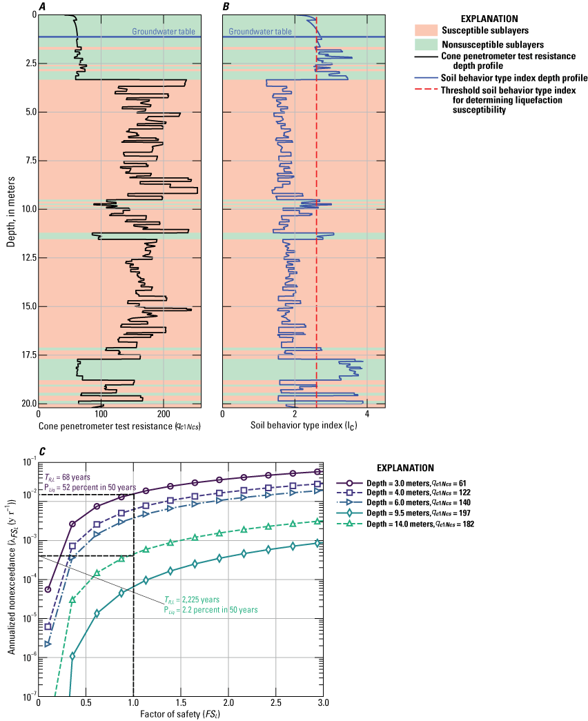
Graphs showing example probabilistic liquefaction hazard calculations for a site in Seattle, Washington (modified from Makdisi and Kramer, 2024b). A, Cone penetrometer test (CPT) data showing the variation with depth of CPT resistance. B, Variation with depth of soil behavior type index (IC). C, Liquefaction triggering factor of safety (FSL) hazard curves that have 50-year probabilities of liquefaction (PLiq) and liquefaction return periods (TR,L) shown at varying depths.
Given the personnel and expertise within the ERP, as well as the collaborative connections to USGS researchers with geotechnical expertise within other GHSC and ESC projects, the ERP has identified several areas of ongoing and future expansions in geotechnical research capabilities, including the following:
-
• Developing regional- and national-scale efforts to map liquefaction hazards throughout the United States, using a combination of geospatial proxy-based predictions and site-specific predictions using the PLHA computational code (where geotechnical data are available, for example the USGS EHP Map of CPT Data [https://earthquake.usgs.gov/research/cpt/data/]). A national liquefaction map would meet a range of external needs (for example, the NEHRP Reauthorization Act of 2018, FEMA, National Institute of Building Sciences, BSSC, and Federal Highway Administration). Although current (2025) resources and personnel are well-positioned to make progress on a technical framework for achieving this goal and producing preliminary or prototype maps, longer-term efforts towards code maintenance, data management, and periodic updates would require project expansion and additional resources.
-
• Establishing consistency in means and methods used to map earthquake-induced ground failure within the context of long-term hazard and risk forecasting, and near-real-time effects and scenario assessment (for example, PAGER and ShakeCast; fig. 8). This coordination and development can largely be achieved among current (2025) USGS personnel.
-
• Expanding probabilistic earthquake ground failure hazard forecasting towards evaluating effects on infrastructure and risk, and a goal of such efforts to inform improvements to building code provisions to achieve life safety (preventing building collapse and resulting casualties and loss of life) and functional recovery (minimizing re-occupancy times for residential and commercial infrastructure) performance objectives. This effort can be most directly achieved, using existing resources and personnel, by leveraging and integrating external research advances as they become available into the USGS PLHA code.
-
• Using physics-based simulations of liquefiable geotechnical systems to supplement gaps in field observations of liquefaction-induced ground and infrastructure damage. Areas that could fill gaps include studying near-field effects on liquefaction hazards, the effects of long-duration ground motions from subduction zone earthquakes on liquefaction hazards, and complex SSI effects. Although the ERP group has developed inhouse simulation capabilities to meet these needs for smaller-scale preliminary studies (for example, Makdisi and others, 2024), more sustained long-term research in this area would require an expansion of project resources and personnel.
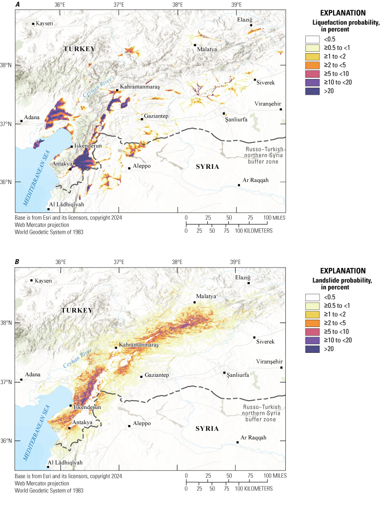
Maps showing A, liquefaction and B, landslide ground failure estimates from the 2023 magnitude 7.8 earthquake in Pazarcik, Turkey (modified from Allstadt and others, 2022). <, less than; ≥, greater than or equal to; >, greater than
Simulation, Validation, and Use of Earthquake Ground Motions
One of the most significant challenges in earthquake hazards research is the lack of high-quality earthquake observations, especially near-source observations, particularly given the lengthy geologic timescales through which such observations are needed to make meaningful conclusions about earthquake occurrences and effects. Among the most promising approaches for addressing this limitation is the use of simulated ground motions using various types of numerical techniques from physics-informed broadband stochastic approaches. Such simulations can generate predictions of strong ground motions in areas where certain events are deemed likely to occur, or are known to have occurred in the past, but before the advent and proliferation of ground motion recording instrumentation. The recognition of the importance of earthquake ground motion simulations is evident in the USGS’s collaboration with the NSF to jointly fund the SCEC—a significant contributor to the research on simulation of ground motions. The ERP has collaborated with the SCEC throughout the years to coordinate on projects to develop validation approaches for simulations with the goal of promoting using simulated ground motions in engineering practice.
A critical component of earthquake research is understanding how ground motions will affect infrastructure and human populations. A lack of observational data is a similar challenge for engineering researchers, but one that can also be addressed by using simulations. Earthquake engineers have long used numerical tools to simulate the response of structural and geotechnical systems to a wide range of earthquake ground motions, in practical settings (such as, nonlinear response history analysis of a single site or structure) and research applications (such as, large-scale parametric studies or regional-scale simulations). Research on strong ground motion simulations (Rezaeian and others, 2024), validation of already simulated motions, and use in engineering applications represents a growth opportunity for ERP because several personnel additions to the ERP have substantial prior experience and interest in numerical modeling. Potential efforts that could be established in the relative near-term include the following:
-
• Continued research on improving broadband stochastic simulations for all tectonic regions within and outside of the United States and for regional effects such as near-fault simulations; the goal is better representing ground motion variabilities.
-
• Research on ground motion selection techniques for structural and geotechnical nonlinear response history analysis in engineering applications.
-
• Validation of simulated ground motions for engineering applications.
-
• Development of validation frameworks for simulated ground motions, in collaboration with the SCEC Ground Motion Simulation Validation group and the newly formed simulation group of Consortium of Organizations for Strong Motion Observation Systems (COSMOS; https://strongmotion.org/), for structural and geotechnical engineering and SSI-related applications. Efforts may lead to future internal research using simulated motions to explore the effects of certain ground motion characteristics that cannot be studied purely from historical data (for example, long-duration motions from subduction environments or near-field pulses), or to further collaborate with the NSHM project to use validated simulations in future update cycles.
Given the opportunity for further expansion in staff, ERP can work on the following topics: Development of computational workflows and protocols internally for structural and geotechnical modeling using open-source simulation software (OpenSees, https://opensees.berkeley.edu/) and potential scalability to high-performance computing environments (for example, Amazon Web Services [AWS; https://aws.amazon.com/hpc/] and Natural Hazards Engineering Research Infrastructure [NEHRI] DesignSafe [https://www.designsafe-ci.org/]). Such efforts would expand earthquake engineering research capabilities in the following areas:
-
• Development of simulation-based parametric studies of free-field liquefiable systems (that is, without the presence of structural systems) to systematically provide new insights (for example, ground motion characteristics that most efficiently describe liquefaction effects, interactions among multiple liquefiable layers, and the timing of liquefaction and its effect on ground deformations) and potentially serve as the basis for new empirical liquefaction prediction models.
-
• Using simulations to fill knowledge gaps in SSI problems (for example, improving SSI modeling in liquefiable soils, how timing of liquefaction affects foundation or superstructure response, and inertial and kinematic SSI effects in soft or loose soils).
-
• Collaboration with the NSF-funded NHERI SimCenter (https://simcenter.designsafe-ci.org/) on simulating natural hazards effects at the regional scale, specifically to risk assessment for lifelines (for example, the Regional Resilience Determination [R2D] tool [https://simcenter.designsafe-ci.org/research-tools/r2dtool/] and the SCEC project with the University of California at Berkeley).
-
• Expansion of ongoing collaborations with the Corps in seismic risk assessment of dams. Current (2025) collaborations are limited to seismic hazard assessments and ground motion selection and modification for nonlinear analysis of dams, but future efforts could be aimed at improving numerical models of the dams themselves using ERP expertise.
Summary
The U.S. Geological Survey’s Engineering and Risk Project (ERP) is responsible for key research and product deliverables that bridge earthquake science and hazards research with engineering risk and practice to mitigate earthquake risk to people and infrastructure. The project relies on the core capabilities of members, covering a broad range of disciplines from engineering seismology to geotechnical and structural engineering with domain expertise on earthquake ground motion characterization, risk, and loss modeling. The ERP has a proven track record of producing high quality research extending hazard science to engineering risk assessment and mitigation through improvements to U.S. building code regulations for new and existing buildings and other infrastructure. The ERP leverages peer-to-peer connections and strong interagency collaborations and is keen on establishing strong ties with external partners in practice and academia. As such, the ERP is uniquely positioned to undertake and maintain long-term projects, which are not as easily addressed by industry or academia, while engaging and coordinating with collaborators and stakeholders on such efforts. The ERP research activities elaborated in this report will continue to evolve to meet the current and future engineering-related development needs of the Earthquake Hazards Program mission.
References Cited
Allstadt, K.E., Thompson, E.M.,Jibson, R.W., Wald, D.J.,Hearne, M.,Hunter, E.J.,Fee, J., Schovanec, H., Slosky, D., and Haynie, K.L., 2022, The U.S. Geological Survey ground failure product—Near-real-time estimates of earthquake-triggered landslides and liquefaction: Earthquake Spectra, v. 38, no.1, p. 5–36, accessed October 13, 2024, at https://doi.org/10.1177/87552930211032685.
American Society of Civil Engineers/Structural Engineering Institute [ASCE/SEI], 2022, Minimum design loads and associated criteria for buildings and other structures: Reston, Va., American Society of Civil Engineers, 975 p., accessed October 13, 2024, at https://doi.org/10.1061/9780784415788.
Centers for Disease Control and Prevention, 2001, Earthquake-associated deaths—California: Centers for Disease Control and Prevention MMWR Weekly, November 17, 1989, accessed February 18, 2025, at https://www.cdc.gov/mmwr/preview/mmwrhtml/00001498.htm. [Page electronically converted August 5, 1998, and last reviewed May 2, 2001.]
Chase, R.E., Jaiswal, K.S., and Petersen, M.D., 2024, Earthquake scenario development in conjunction with the 2023 USGS National Seismic Hazard Model: Earthquake Spectra, v. 40, no. 3, p. 1818–1844, accessed October 13, 2024, at https://doi.org/10.1177/87552930241253837.
DuRoss, C.B., Reitman, N.G., Hatem, A.E., Mason, H.B., Lavrentiadis, G., Milliner, C., Asimaki, D., Karakaş, M., and Seçen, B., 2024, Field observations of surface rupture and fault displacement in the 2023 Mw 7.8 Pazarcık, Türkiye earthquake: U.S. Geological Survey data release, accessed October 13, 2024, at https://doi.org/10.5066/P969BHT4.
Federal Emergency Management Agency [FEMA], 2020a, Building codes save—A nationwide study—Losses avoided as a result of adopting hazard-resistant building codes: Federal Emergency Management Agency, 189 p., accessed February 18, 2025, at https://www.fema.gov/sites/default/files/2020-11/fema_building-codes-save_study.pdf.
Federal Emergency Management Agency [FEMA], 2020b, NEHRP recommended seismic provisions—Seismic design category maps for 2024 International Residential Code (IRC) and International Building Code (IBC): Federal Emergency Management Agency report no. FEMA P-2192-4, 32 p., accessed October 13, 2024, at https://www.fema.gov/sites/default/files/documents/fema_p-2192-nehrp-provisions-seismic-design-maps-2024-irc-ibc.pdf.
Federal Emergency Management Agency [FEMA], 2021, Recommended options for improving the built environment for post-earthquake reoccupancy and functional recovery time: Federal Emergency Management Agency and National Institute of Standards and Technology report no. FEMA P-2090/NIST SP-1254 [Special Publication], 135 p., accessed October 13, 2024, at https://doi.org/10.6028/NIST.SP.1254.
Federal Emergency Management Agency [FEMA], 2022, Hazus (ver. 6.0, November 2022): Federal Emergency Management Agency, accessed August 2023 at https://msc.fema.gov/portal/resources/hazus.
Hayes, G.P., Baltay Sundstrom, A.S., Barnhart, W.D., Blanpied, M.L., Davis, L.A., Earle, P.S., Field, N., Franks, J.M., Given, D.D., Gold, R.D., Goulet, C.A., Guy, M.M., Hardebeck, J.L., Luco, N., Pollitz, F., Ringler, A.T., Scharer, K.M., Sobieszczyk, S., Thomas, V.I., and Wolfe, C.J., 2024, U.S. Geological Survey Earthquake Hazards Program decadal science strategy, 2024–33: U.S. Geological Survey Circular 1544, 55 p., accessed February 17, 2025, at https://doi.org/10.3133/cir1544.
Jaiswal, K.S., Luco, N., Schnebele, E.K., Nassar, N.T., and Otarod, D., 2024, Quantitative risk of earthquake disruption to global copper and rhenium supply: U.S. Geological Survey Open-File Report 2024–1028, 19 p., accessed October 13, 2024, at https://doi.org/10.3133/ofr20241028.
Jaiswal, K., Rozelle, J.,Tong, M.,Sheehan, A.,McNabb, S.,Kelly, M.,Zuzak, C.,Bausch, D., and Sims, J., 2023, Hazus estimated annualized earthquake losses for the United States: Federal Emergency Management Agency report no. FEMA P-366, 98 p., accessed October 13, 2024, at https://www.fema.gov/sites/default/files/documents/fema_p-366-hazus-estimated-annualized-earthquake-losses-united-states.pdf.
Kortum, Z., 2021, Impacts of Cascadia Subduction Zone M9 earthquakes on bridges in Washington State—SDOF idealized bridges: Seattle, Wash., University of Washington, M.S. thesis, 24 p., accessed October 13, 2024, at http://hdl.handle.net/1773/47407.
Kwong, N.S., Jaiswal, K.S., Baker, J.W., Luco, N., Ludwig, K.A., and Stephens, V.J., 2022, Earthquake risk of gas pipelines in the conterminous United States and its sources of uncertainty: ASCE-ASME Journal of Risk and Uncertainty in Engineering Systems, Part A, Civil Engineering, v. 8, no. 1, art. 04021081, 22 p., accessed October 13, 2024, at https://doi.org/10.1061/AJRUA6.0001202.
Kwong, N.S., and Jaiswal, K.S., 2023, Uses of epistemic uncertainties in the USGS National Seismic Hazard Models: Earthquake Spectra, v. 39, no. 2, p. 1058–1087, accessed October 13, 2024, at https://doi.org/10.1177/87552930231157424.
Luco, N., Ellingwood, B.R., Hamburger, R.O., Hooper, J.D., Kimball, J.K., and Kircher, C.A., 2007, Risk-targeted versus current seismic design maps for the conterminous United States, in SEAOC 2007 Convention Proceedings, Squaw Creek, Calif., September 26–29, 2007: Sacramento, Calif., Structural Engineers Association of California, 13 p., accessed October 13, 2024, at https://api.semanticscholar.org/CorpusID:127729005.
Ludwig, K.A., Ramsey, D.W., Wood, N.J., Pennaz, A.B., Godt, J.W., Plant, N.G., Luco, N., Koenig, T.A., Hudnut, K.W., Davis, D.K., and Bright, P.R., 2018, Science for a risky world—A U.S. Geological Survey plan for risk research and applications: U.S. Geological Survey Circular 1444, 57 p., accessed October 13, 2024, at https://doi.org/10.3133/cir1444.
Makdisi, A.J., and Kramer, S.L., 2024a, Framework for mapping liquefaction hazard-targeted design ground motions: Journal of Geotechnical and Geoenvironmental Engineering, v. 150, no. 12, 13 p., accessed October 13, 2024, at https://doi.org/10.1061/JGGEFK.GTENG-12804.
Makdisi, A.J., and Kramer, S.L., 2024b, Improved computational methods for probabilistic liquefaction hazard analysis: Soil Dynamics and Earthquake Engineering, v. 176, art. 108272, 23 p., accessed October 13, 2024, at https://doi.org/10.1016/j.soildyn.2023.108272.
Makdisi, A.J., Luco, N., Clayton, B.S., and Kortum, Z.A., 2024, erp-rtgm-calculator—Python source code for USGS risk-targeted ground motion calculator: U.S. Geological Survey software release, accessed October 13, 2024, at https://doi.org/10.5066/P9A2F2B8.
Petersen,M.D., Shumwa,yA.M., Powers,P.M., Mueller, C.S., Moschetti, M.P., Frankel, A.D., Rezaeian, S., McNamara, D.E., Luco, N., Boyd, O.S., Rukstales, K.S., Jaiswal, K.S., Thompson, E.M., Hoover, S.M., Clayton, B.S., Field, E.H., and Zeng, Y., 2019, The 2018 update of the US National Seismic Hazard Model—Overview of model and implications: Earthquake Spectra, v. 36, no. 1, p. 5–41, accessed October 13, 2024, at https://doi.org/10.1177/8755293019878199.
Petersen,M.D., Shumway,A.M., Powers,P.M., Mueller, C.S., Moschetti, M.P., Frankel, A.D., Rezaeian, S., McNamara, D.E., Luco, N., Boyd, O.S., Rukstales, K.S., Jaiswal, K.S., Thompson, E.M., Hoover, S.M., Clayton, B.S., Field, E.H., and Zeng, Y., 2021, The 2018 update of the US National Seismic Hazard Model: Where, why, and how much probabilistic ground motion maps changed: Earthquake Spectra, v. 37, no. 2, p. 959–987, accessed October 13, 2024, at https://doi.org/10.1177/8755293020988016.
Petersen, M.D., Shumway, A.M., Powers, P.M., Field, E.H., Moschetti, M.P., Jaiswal, K.S., Milner, K.R., Rezaeian, S., Frankel, A.D., Llenos, A.L., Michael, A.J., Altekruse, J.M., Ahdi, S.K., Withers, K.B., Mueller, C.S., Zeng, Y., Chase, R.E., Salditch, L.M., Luco, N., Rukstales, K.S., Herrick, J.A., Girot, D.L., Aagaard, B.T., Bender, A.M., Blanpied, M.L., Briggs, R.W., Boyd, O.S., Clayton, B.S., DuRoss, C.B., Evans, E.L., Haeussler, P.J., Hatem, A.E., Haynie, K.L., Hearn, E.H., Johnson, K.M., Kortum, Z.A., Kwong, N.S., Makdisi, A.J., Mason, H.B., McNamara, D.E., McPhillips, D.F., Okubo, P.J., Page, M.T., Pollitz, F.F., Rubinstein, J.L., Shaw, B.E., Shen, Z-K., Shiro, B.R., Smith, J.A., Stephenson, W.J., Thompson, E.M., Thompson Jobe, J.A., Wirth, E.A., and Witter, R.C., 2024, The 2023 US 50-State National Seismic Hazard Model—Overview and implications: Earthquake Spectra, v. 40, no. 1, p. 5–88, accessed October 13, 2024, at https://doi.org/10.1177/87552930231215428.
Rezaeian, S.,Stewart, J.P.,Luco, N., and Goulet, C.A.,2024, Findings from a decade of ground motion simulation validation research and a path forward: Earthquake Spectra, v. 40, no. 1, p. 346–378, accessed October 13, 2024, at https://doi.org/10.1177/87552930231212475.
Silva, V., Amo-Oduro, D., Calderon, A., Costa, C., Dabbeek, J., Despotaki, V., Martins, L., Pagani, M., Rao, A., Simionato, M., Viganὸ, D., Yepes-Estrada, C., Acevedo, A., Crowley, H., Horspool, N., Jaiswal, K., Journeay, M., and Pittore, M., 2020, Development of a global seismic risk model: Earthquake Spectra, v. 36, no 1 (suppl.), p. 372–394, accessed February 18, 2025, at https://doi.org/10.1177/8755293019899953.
Stock, G.M., Luco, N., Collins, B.D., Harp, E.L., Reichenbach, P., and Frankel, K.L., 2014, Quantitative rock-fall hazard and risk assessment for Yosemite Valley, Yosemite National Park, California: U.S. Geological Survey Scientific Investigations Report 2014–5129, 52 p., accessed October 13, 2024, at https://doi.org/10.3133/sir2014512.
Abbreviations
AI
Arias intensity
ASCE/SEI
American Society of Civil Engineers/Structural Engineering Institute
AWS
Amazon Web Services
BSSC
Building Seismic Safety Council
CAV
cumulative absolute velocity
COSMOS
Consortium of Organizations for Strong Motion Observation Systems
Corps
U.S. Army Corps of Engineers
EHP
U.S. Geological Survey Earthquake Hazards Program
ERP
U.S. Geological Survey Engineering and Risk Project
ESC
U.S. Geological Survey Earthquake Science Center
FEMA
Federal Emergency Management Agency
FERC
Federal Energy Regulatory Commission
GHSC
U.S. Geological Survey Geologic Hazards Science
HazDev
Hazards Development
NEHRI
Natural Hazards Engineering Research Infrastructure
NEHRP
National Earthquake Hazards Reduction Program
NIST
National Institute of Standards and Technology
NSF
National Science Foundation
NSHM
National Seismic Hazard Model
PAGER
Prompt Assessment of Global Earthquakes for Response
PLHA
probabilistic liquefaction hazard analysis
R2D
Regional Resilience Determination
SCEC
Southern California Earthquake Center
SSI
soil–structure interaction
USGS
U.S. Geological Survey
Publishing support provided by the Science Publishing Network,
Denver Publishing Service Center
For more information concerning the research in this report, contact the
Center Director, USGS Geologic Hazards Science Center
Box 25046, Mail Stop 966
Denver, CO 80225
(303) 273-8579
Or visit the Geologic Hazards Science Center website at
https://www.usgs.gov/centers/geologic-hazards-science-center
Disclaimers
Any use of trade, firm, or product names is for descriptive purposes only and does not imply endorsement by the U.S. Government.
Although this information product, for the most part, is in the public domain, it also may contain copyrighted materials as noted in the text. Permission to reproduce copyrighted items must be secured from the copyright owner.
Suggested Citation
Jaiswal, K.S., Rezaeian, S., Luco, N., Kwong, N.S., Makdisi, A.J., Mason, H.B., Chase, R.E., and Kortum, Z.A., 2025, Engineering and risk research—A strategic vision for extending USGS earthquake science to risk assessment and mitigation: U.S. Geological Survey Circular 1555, 19 p., https://doi.org/10.3133/cir1555.
ISSN: 2330-5703 (online)
Study Area
| Publication type | Report |
|---|---|
| Publication Subtype | USGS Numbered Series |
| Title | Engineering and risk research—A strategic vision for extending USGS earthquake science to risk assessment and mitigation |
| Series title | Circular |
| Series number | 1555 |
| DOI | 10.3133/cir1555 |
| Publication Date | June 10, 2025 |
| Year Published | 2025 |
| Language | English |
| Publisher | U.S. Geological Survey |
| Publisher location | Reston VA |
| Contributing office(s) | Geologic Hazards Science Center - Seismology / Geomagnetism |
| Description | iv, 19 p. |
| Country | United States |
| Online Only (Y/N) | Y |