

Summary of Selenium in the Lower Gunnison River Basin, Colorado—Information and Data Gaps
Links
- Document: Report (36.9 MB pdf) , HTML , XML
- NGMDB Index Page: National Geologic Map Database Index Page (html)
- Download citation as: RIS | Dublin Core
Abstract
The Cretaceous Mancos Shale is a geologic source of selenium in the lower Gunnison River Basin. Natural weathering processes and human activity mobilize selenium from the Mancos Shale and derived materials, and surface water, groundwater, and sediment all affect the transport of selenium from source areas to receiving streams and biota. Selenium accumulates through the aquatic food chain, and its toxic effects can result in invertebrate mortality and mortality, decreased reproduction, and deformities to fish and birds. The Bureau of Reclamation, in cooperation with the State of Colorado and Gunnison River Basin water users, is implementing a Selenium Management Program to reduce selenium concentrations in the lower Gunnison River Basin of Colorado. Goals of the Selenium Management Program are to (1) achieve compliance with the State of Colorado chronic aquatic-life standard for dissolved selenium (4.6 micrograms per liter) in the Gunnison River near Grand Junction, Colorado; (2) sufficiently improve water-quality conditions to assist in the recovery of endangered species in the Gunnison and Colorado Rivers by reducing selenium concentrations; and (3) support continued water uses in the basin.
Many previous studies have contributed to the understanding of selenium in the environment; however, monitoring and research data gaps exist in the lower Gunnison River Basin. The purpose of this report is to summarize information regarding selenium in the lower Gunnison River Basin and describe strategies for scientific research and monitoring to potentially improve understanding of selenium sources; processes affecting the mobilization, transport, and fate of selenium; and the effects of selenium-mitigation projects in the lower Gunnison River Basin. Monitoring and research data gaps discussed in this report include geologic mapping and geochemical source characterization, long-term and ongoing monitoring of the surface-water and groundwater networks, developing and refining statistical models, characterizing selenium on suspended sediment, modeling selenium in the food web, evaluating best management practices, and more.
Introduction
The Bureau of Reclamation (Reclamation), in cooperation with the State of Colorado and Gunnison River Basin water users, implemented a Selenium Management Program (SMP) to reduce selenium concentrations in the lower Gunnison River Basin of Colorado (Reclamation, 2011), as required by a Programmatic Biological Opinion (PBO) issued by the U.S. Fish and Wildlife Service (FWS) in 2009. The goals, as described in the SMP formulation document (Reclamation, 2011), are to (1) achieve compliance with the State of Colorado chronic aquatic-life standard for dissolved selenium (4.6 micrograms per liter [μg/L]) in the Gunnison River near Grand Junction, Colorado; (2) sufficiently improve water-quality conditions to assist in the recovery of endangered species in the Gunnison and Colorado Rivers (primarily Ptychocheilus lucius [Colorado pikeminnow] and Xyrauchen texanus [razorback sucker]) in critical habitat from Delta, Colo., to Grand Junction, Colo., by reducing selenium concentrations; and (3) support continued water uses in the basin. The SMP describes recovery of endangered fish as “naturally occurring, reproducing populations” that are “self-sustaining, with all life stages present and there is natural recruitment into the adult population” (Reclamation, 2011, p. 4). Selenium concentrations in the lower Gunnison and Uncompahgre Rivers, as well as in several tributaries, have historically exceeded Colorado water-quality standards (Butler and Leib, 2002; Thomas and others, 2008); however, there is a strong statistically significant downward trend in selenium concentrations and loads since the 1980s (Reclamation, 2011; Henneberg, 2016, 2018, 2020; Henneberg and others, 2021). Although 66 miles of the Gunnison River downstream from Delta officially achieved compliance with the Colorado water-quality standard in 2021 (Colorado River Water Conservation District, 2021), continued monitoring and studies performed as part of the SMP may support further characterization of the sources, transport, and fate of selenium in the lower Gunnison River Basin.
Purpose and Scope
This report was prepared in cooperation with the Colorado Water Conservation Board, Reclamation, Colorado River Water Conservation District, FWS, Bureau of Land Management, and Natural Resources Conservation Service (NRCS). The purpose of this report is to (1) summarize information regarding selenium in the lower Gunnison River Basin; and (2) describe and identify monitoring and research efforts that may support a more complete understanding of selenium sources, mobilization, transport, fate, and the effects of mitigation projects in the lower Gunnison River Basin. Multiple Federal, State, and local agencies are investigating salinity and selenium issues in the lower Gunnison River Basin, and the SMP maintains a working database of planned and active selenium-mitigation projects being led by Reclamation. This report could support and complement the goals of the SMP by identifying data gaps to better understand selenium in the lower Gunnison River Basin.
Background
Selenium is an essential trace element and dietary micronutrient for humans and animals, but the intake of elevated levels of selenium can be toxic to humans and wildlife (Stadtman, 1974; Gissel-Nielsen and others, 1984; Lemly, 1996, 2002). In the semiarid Western United States, weathering of selenium-bearing rocks and derived sediment contributes dissolved selenium to rivers by natural and human-caused processes (Seiler and others, 1999, 2003; Presser, Hardy, and others, 2004; Presser, Piper, and others, 2004). In western Colorado, the Cretaceous Mancos Shale of marine origin is the primary selenium-bearing formation. Rainfall runoff, wind, infiltration, recharge, and groundwater and surface-water interaction processes naturally weather and erode the selenium-bearing rocks, releasing dissolved selenium to the aquatic environment. These same weathering and erosion processes also generate salinity (dissolved solids) because they release major ions (sulfate, nitrate, calcium, sodium, and chloride), dissolved organic carbon, and other trace elements to groundwater and surface water from rocks and soils in the surrounding basin. Weathering processes are accelerated by water use on the land surface in irrigated areas (Butler and others, 1996; Seiler and others, 2003), and irrigation of agricultural fields or in suburban areas in semiarid climates is considered a primary mechanism of mobilization and movement of selenium from geologic sources to streams (Butler and others, 1996; Seiler and others, 1999, 2003131).
Selenium present in aquatic systems can cycle in and out of the water column because of complexation, adsorption, evaporation, and oxidation-reduction (redox) chemical reactions (McNeal and Balistrieri, 1989; Lemly, 2002). Dissolved and particulate selenium accumulate through the aquatic food chain, and the toxic effects can result in invertebrate mortality (deBruyn and Chapman, 2007; Conley and others, 2013; Henry and Wesner, 2018) and mortality, decreased reproduction, and deformities to fish and birds (Lemly, 1985; Ohlendorf and others, 1986; Ohlendorf, 1989; Presser, 1994). The U.S. Environmental Protection Agency (EPA) has established a primary drinking-water standard for selenium of 50 μg/L (EPA, 2003), and, in 1997, the State of Colorado adopted the criteria of 4.6 μg/L for a chronic aquatic-life standard for selenium (Colorado Department of Public Health and Environment [CDPHE], 2008). EPA guidance recommends the use of chronic aquatic-life criterion that include egg-ovary, whole body, muscle, and water-column concentrations (EPA, 2016).
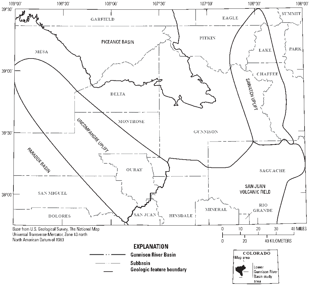
In Colorado, numerous streams are included on the State’s list of impaired waters through provisions of Section 303(d) of the Clean Water Act (33 U.S.C. §1251 et seq.). These streams are on the so-called “Colorado Section 303(d) List,” because concentrations of dissolved selenium exceed the chronic aquatic-life standard of 4.6 μg/L (fig. 1). Many selenium-impaired streams in Colorado are associated with nonpoint source discharge from areas underlain by selenium-bearing Cretaceous shale geologic formations such as the Mancos Shale in western Colorado (Butler and others, 1996; Tuttle and others, 2005) or the Pierre Shale and the Niobrara Formation in central and eastern Colorado (Gates and others, 2009; Ivahnenko and others, 2013; Bern and Stogner, 2017) (fig. 1). The Gunnison River Basin in western Colorado is a major tributary to the Colorado River. Many tributaries in the lower Gunnison River Basin are underlain by the Mancos Shale and several are on the Colorado Section 303(d) List for dissolved selenium concentrations that consistently exceed the aquatic-life standard (figs. 1, 2; table 1).
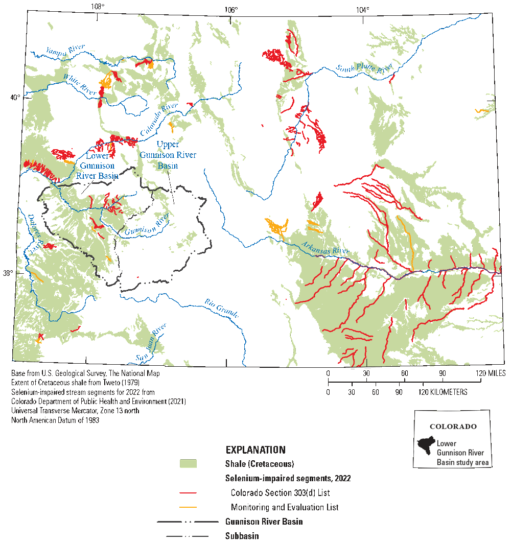
Map showing surficial extent of Cretaceous shale in Colorado and selenium-impaired stream segments on the Colorado Section 303(d) List in 2022. Extent of Cretaceous shale from Tweto (1979). Selenium-impaired stream segments for 2022 from Colorado Department of Public Health and Environment (CDPHE, 2021).
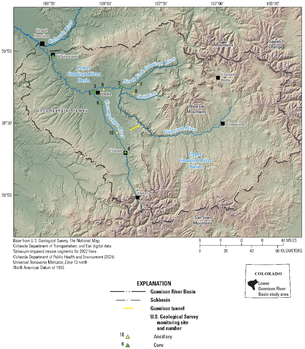
Map showing the lower Gunnison River Basin, its major tributaries, and selected U.S. Geological Survey (USGS) surface-water monitoring sites from the USGS National Water Information System database (USGS, 2021b). Information on the monitoring sites is provided in table 1.
Table 1.
List of selected U.S. Geological Survey (USGS) surface-water monitoring sites in the lower Gunnison River Basin, Colorado.[Site information is from the USGS National Water Information System database (USGS, 2021b). Refer to the “Surface Water” section of this report for additional information. CO, Colorado; Fk, Fork; nr, near; blw, below; Cty, County]
| Map identifier (figs. 2, 13) | Site number | Site name |
|---|---|---|
| 1 | 09152500 | Gunnison River near Grand Junction, CO |
| 2 | 09136100 | North Fk Gunnison River above mouth nr Lazear, CO |
| 3 | 09144250 | Gunnison River at Delta, CO |
| 4 | 09147500 | Uncompahgre River at Colona, CO |
| 5 | 09149500 | Uncompahgre River at Delta, CO |
| 6 | 383946107595301 | Loutsenhizer Arroyo blw North River Road nr Delta, CO |
| 7 | 384822107411201 | Cottonwood Creek at Cty Road J75 nr mouth |
| 8 | 384434107432701 | Alum Gulch nr Hotchkiss, CO |
| 9 | 384551107591901 | Sunflower Drain at Highway 92, near Read |
| 10 | 382802107513301 | Montrose Arroyo at East Niagara Street |
In 2009, the FWS issued a PBO that evaluated the effects of water-use projects on endangered species in the Gunnison River Basin. The PBO stated, “the ongoing operation of irrigation projects and other water uses in the basin will continue to contribute selenium to the Gunnison and Colorado Rivers at levels that adversely affect the endangered fishes and their designated critical habitat and are inhibiting the survival and recovery of the endangered fishes” (FWS, 2009, p. 15). To address these concerns, the PBO called for the creation of a program to implement selenium-reduction efforts. Since its formation, the SMP has supported many improvement projects, studies, and education throughout the lower Gunnison River Basin (Ward and others, 2021). Monitoring data indicated a significant downward trend in selenium concentrations since the 1980s (Reclamation, 2011; Henneberg, 2016, 2018, 2020; Henneberg and others, 2021), and in 2021, the Gunnison River was removed from the list of impaired waters. This milestone represents achievement of the first SMP goal to comply with the State of Colorado aquatic-life standard for dissolved selenium (Reclamation, 2011) and could allow for more focus on the second goal, recovery of endangered fish. This topic could be especially important because aquatic organisms are primarily exposed to selenium through the food web (Chapman and others, 2010), and water-quality standards based on dissolved selenium concentrations alone do not meet EPA recommendations for selenium criteria, which include both fish-tissue and water-quality components (EPA, 2016).
Study Area Description
The lower Gunnison River Basin includes the North Fork of the Gunnison River, the Smith Fork, the main stem of the Gunnison River downstream from the Gunnison Tunnel, and the Uncompahgre River downstream from Colona, Colo. (fig. 2). This section provides an overview of the study area setting. Although the lower Gunnison River Basin is the focus of the report, information on the upper Gunnison River Basin is discussed for comparison and to provide context.
Physiography
Located in western Colorado, the main stem of the Gunnison River originates in the West Elk Mountains near Crested Butte and flows southwest toward Gunnison before turning west and then northwest toward its confluence with the North Fork of the Gunnison River (fig. 2). The North Fork of the Gunnison River flows west from the headwaters in the northeast part of the lower Gunnison River Basin; the Uncompahgre River drains the southern and western parts of the lower Gunnison River Basin, originating in the San Juan Mountains near Ouray, Colo. The Uncompahgre River joins the Gunnison River near Delta, Colo., and the confluence of the Gunnison and Colorado Rivers is in Grand Junction, Colo. (fig. 2).
Physiography of the Gunnison River Basin is characterized by high mountains (elevation up to greater than 14,000 feet) on the eastern and southern edges of the basin, where winter snowpack accumulation supports annual spring snowmelt and runoff that supplies surface water to lower elevations (Sprenger and others, 2024). For the 1981–2010 period of record, average annual precipitation in the mountainous areas ranged from 21 to 71 inches per year with the greatest precipitation falling at the highest elevations (PRISM Climate Group, 2012; fig. 3). A semiarid climate and desert landscape prevail (fig. 4) in lower elevations and downstream parts of the basin, where average annual precipitation ranged from 7 to 20 inches per year for the 1981–2010 period of record (PRISM Climate Group, 2012; fig. 3).
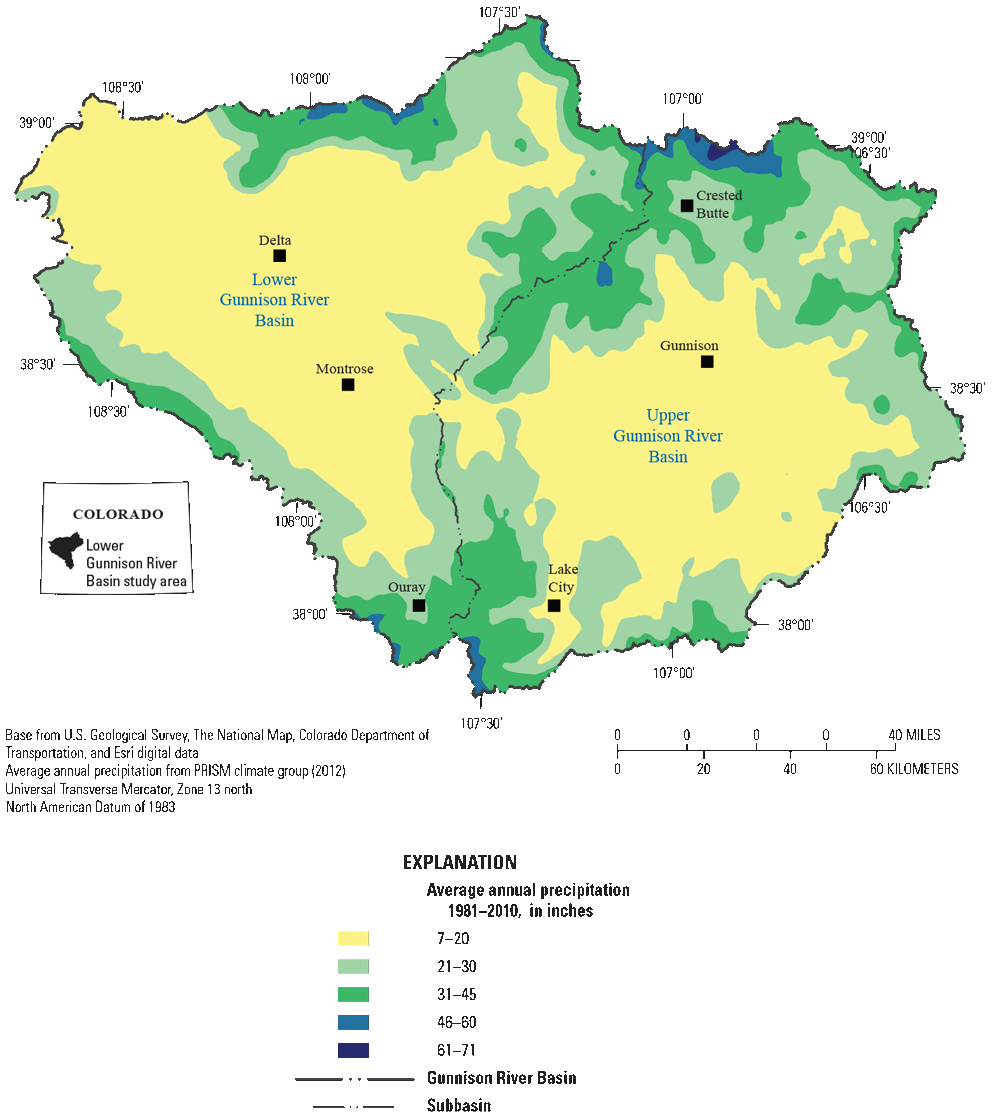
Map showing average annual precipitation for the period 1981–2010 in the Gunnison River Basin, Colorado. Average annual precipitation data from PRISM Climate Group (2012).
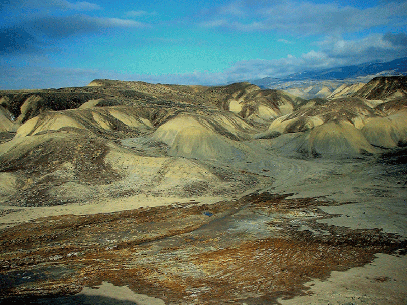
Photograph showing landscape with Mancos Shale in western Colorado. Unirrigated adobe hills of Mancos Shale are in the background. Dark brown coloration in the foreground indicates near-surface shale and soils that are saturated from canal leakage and (or) irrigation. Photograph by Kenneth Leib, U.S. Geological Survey, 2001.
Geologic Setting
The distribution of Paleozoic and Mesozoic sedimentary and volcanic rocks that overlie Precambrian intrusive and metamorphic rocks in the Gunnison River Basin (Lohman, 1965; Tweto, 1979) was established by the geologic history of sediment deposition, tectonics, and volcanism in the central Rocky Mountains during the past 1.7 billion years (Hettinger and others, 2003). The lower Gunnison River Basin is north of the Uncompahgre Plateau along the southeast edge of the structural Piceance basin, west of the Sawatch Uplift (within Delta, Gunnison, Mesa, Montrose, Ouray Counties; figs. 2, 5). The Mesozoic Morrison and Dakota Formations cap the Uncompahgre Plateau and dip gently to the north–northeast toward the structural Piceance basin (Hettinger and others, 2003). Coal and lignite deposits occur in the Dakota Formation on the west side of the lower Gunnison River Basin (Hettinger and others, 2003), and these coal deposits, in addition to Mancos Shale, could be potential sources of selenium to selenium-impaired streams on the western side of the lower Uncompahgre River (Butler and others, 1996; Adriano, 2001; Tuttle and others, 2005; Paschke and others, 2014). Laramide faulting and folding of the Sawatch Range, Elk and West Elk Mountains, and Uncompahgre Plateau contributed further to complex geologic structure in high-elevation parts of the Gunnison River Basin, and much of the Paleozoic section is missing in some areas because of an erosional unconformity on top of the Precambrian rocks (Lohman, 1965). The Mancos Shale (fig. 6) overlies the Dakota Sandstone. The Mancos Shale dips gently toward the north–northeast off the Uncompahgre Plateau and west–northwest off the Elk and West Elk Mountains into the structural Piceance basin. Tertiary volcanic rocks are intruded into the stratigraphic section in a series of calderas that formed the San Juan volcanic field (fig. 5).
Map showing major structural features near the Gunnison River Basin, Colorado (modified from Hettinger and others, 2003).
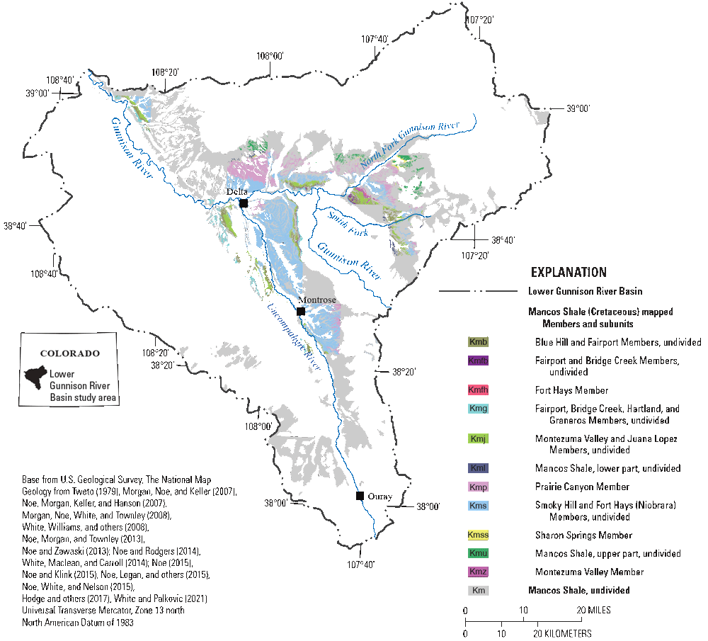
Map showing members and subunits of the Mancos Shale in the lower Gunnison River Basin, Colorado. Geology from Tweto (1979); Morgan, Noe, and Keller (2007); Noe, Morgan, Keller, and Hanson (2007); Morgan, Noe, White, and Townley (2008); White, Williams, and others (2008); Noe, Morgan, and Townley (2013); Noe and Zawaski (2013); Noe and Rodgers (2014); White, Maclean, and Carroll (2014); Noe (2015); Noe and Klink (2015); Noe, Logan, and others (2015); Noe, White, and Nelson (2015); Hodge and others (2017); and White and Palkovic (2021). (Kmb, Blue Hill and Fairport Members, undivided; Kmfb, Fairport and Bridge Creek Members, undivided; Kmfh, Fort Hays Member; Kmg, Fairport, Bridge Creek, Hartland, and Graneros Members, undivided; Kmj, Montezuma Valley and Juana Lopez Members, undivided; Kml, Mancos Shale, lower part, undivided; Kmp, Prairie Canyon Member; Kms, Smoky Hill and Fort Hays [Niobrara] Members, undivided; Kmss; Sharon Springs Member; Kmu, Mancos Shale, upper part, undivided; Kmz, Montezuma Valley Member. The Blue Hill and Fairport Members of the Mancos Shale are from Morgan, Noe, and Keller [2007]; Noe, Morgan, Keller, and Hanson [2007]; Morgan, Noe, White, and Townley [2008]; White, Williams, and others [2008]; Noe, Morgan, and Townley [2013]; Noe and Zawaski [2013]; Noe and Rodgers [2014]; White, Maclean, and Carroll [2014]; Noe and Klink [2015]; Noe, Logan, and others [2015]; and Hodge and others [2017] and Morgan, Noe, and Keller [2007]. The Smoky Hill Member of Mancos Shale is from Morgan, Noe, and Keller [2007]; Noe, Morgan, Keller, and Hanson [2007]; Morgan, Noe, White, and Townley [2008]; White, Williams, and others [2008]; Noe, Morgan, and Townley [2013]; Noe and Zawaski [2013]; Noe and Rodgers (2014); White, Maclean, and Carroll [2014]; Noe [2015]; Noe and Klink [2015]; Noe, Logan, and others [2015]; Noe, White, and Nelson [2015]; and Hodge and others [2017]. The Sharon Springs Member of Mancos Shale is from Noe, Morgan, Keller, and Hanson [2007]; Noe and Zawaski [2013]; Noe and Rodgers [2014]; Noe [2015]; Noe and Klink [2015]; and Noe, White, and Nelson [2015].)
The Mancos Shale occurs primarily in the lower-elevation and semiarid western half of the Gunnison River Basin (fig. 7) and is a major source of selenium (Mast and others, 2014; Tuttle and others, 2014a, b). The Mancos Shale is a marine shale 4,000–5,000 feet thick that was deposited in a Cretaceous inland sea (Lohman, 1965; Hettinger and others, 2003). The Mancos Shale consists of carbonaceous and organic fissile shale containing limited interbedded sandstones (Lohman, 1965). The Mancos Shale underlies the valleys at Grand Junction, Colo., and along the lower Gunnison and Uncompahgre Rivers. These large valleys in the lower Gunnison River Basin, “owe their origin to the ease with which the thick, soft Mancos Shale has been eroded” (Lohman, 1965, p. 66). The Mancos Shale is flat in the lower Gunnison River Basin, forming low adobe hills (fig. 4) dissected by rainfall runoff and arroyos.
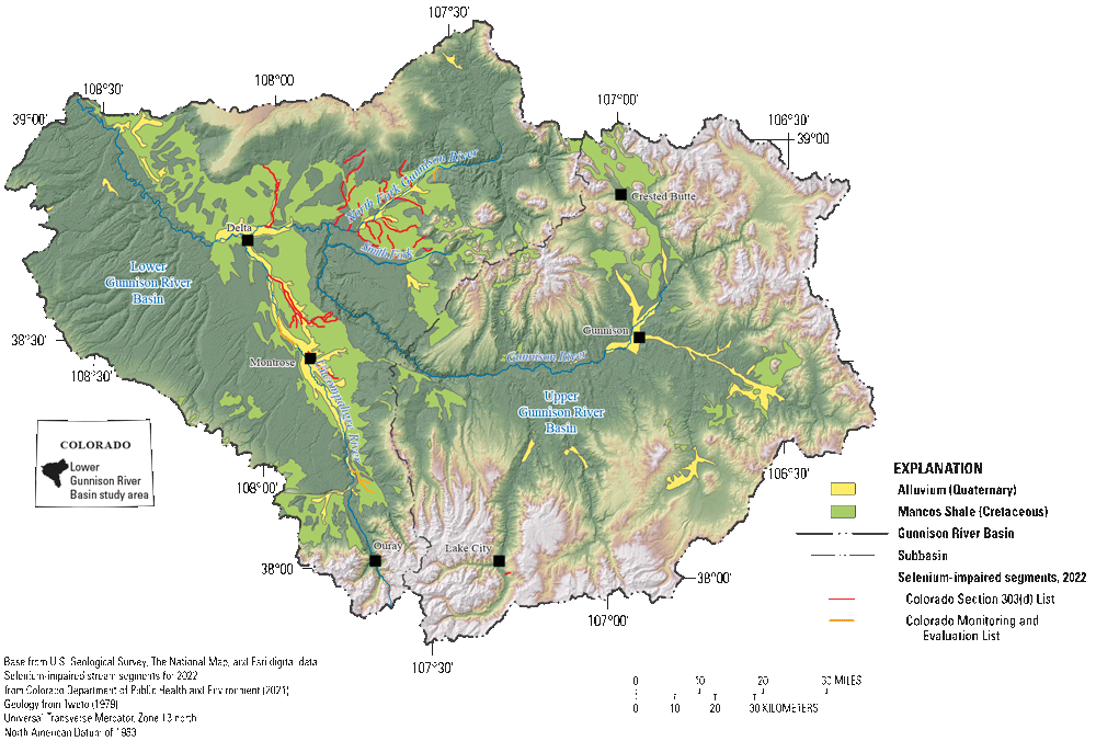
Map showing surficial extent of Cretaceous Mancos Shale, Quaternary alluvial deposits, and selenium-impaired stream segments on the Colorado Section 303(d) List of Impaired Waters or Monitoring and Evaluation List in 2022, Gunnison River Basin, Colorado. Selenium-impaired stream segments for 2022 from Colorado Department of Public Health and Environment (CDPHE, 2021). Geology from Tweto (1979).
Quaternary glacial deposits occur at high elevations in the mountainous areas of the basin, and Quaternary alluvial, colluvial, and aeolian deposits occur in the lower elevations along drainages (Tweto, 1979; fig. 7). In the lower Gunnison River Basin, there are Quaternary terraces above stream channels that can be coarse grained (Hettinger and others, 2003); however, Quaternary deposits and soils formed along streams in areas overlying bedrock of Mancos Shale are generally fine grained and derived from the weathering of Mancos Shale (Lohman, 1965; Tweto, 1979).
Land and Water Use
Land cover in the Gunnison River Basin is characterized by alpine and forested areas, pasturelands, cultivated areas, and mixed-use development (Dewitz and U.S. Geological Survey [USGS], 2021; fig. 8). Forested areas, perennial ice and snow, and barren land compose about 55 percent of the river basin and are primarily in the mountains and higher elevations where the snowpack and precipitation are greatest. At lower elevations with less precipitation, native shrublands, grasslands, and wetlands are present and compose about 38 percent of the Gunnison River Basin area. Pasturelands are primarily along the river valleys and represent about 3 percent of the basin area. Cultivated crops (irrigated agriculture) represent only about 1 percent of the land cover in the basin, but this irrigated agriculture is concentrated in the lower parts of the Gunnison and Uncompahgre River Basins in an area overlying Mancos Shale and Quaternary alluvial deposits (fig. 7). Developed areas represent about 1 percent of the basin area, and Gunnison, Montrose, and Delta are the largest municipalities.
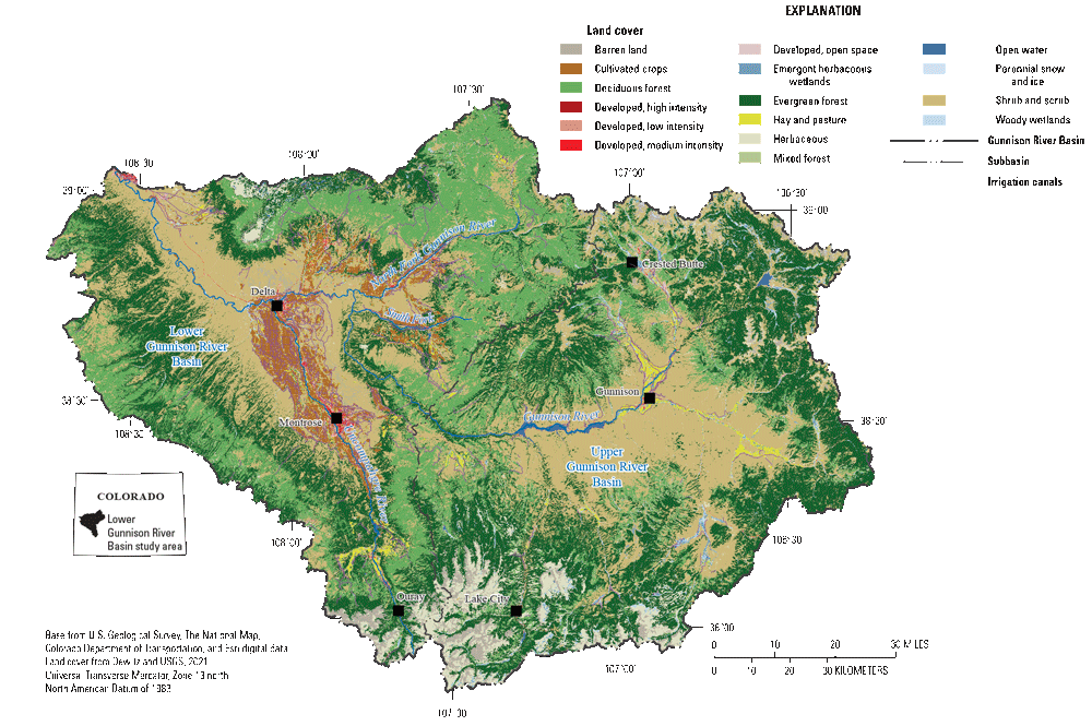
Map showing land cover and irrigation canals in the Gunnison River Basin, Colorado.
Surface water is the primary source of water supply for municipal and agricultural uses in the lower Gunnison River Basin. Natural surface drainages and canals move water from headwater areas to downstream reservoirs for domestic and municipal uses and to agricultural fields to irrigate pastureland and crops. The Gunnison Tunnel (fig. 2) transfers water from the Gunnison River Basin to the Uncompahgre River Basin to support municipal water demands and irrigated agricultural fields in the lower Uncompahgre River Basin. Irrigation canals distribute surface water to irrigate lands in the valleys and lower basin, and irrigation water is a source of recharge to the shallow groundwater system (Mills and others, 2016, Thomas and others, 2019).
Selenium Geochemistry
Many rocks and minerals contain selenium and provide source material for environmental selenium (McNeal and Balistrieri, 1989). Coal and organic-rich, fine-grained sediment (claystone and shale) tend to have high selenium concentrations (Adriano, 2001). These concentrations can range from 0.5 to 11 milligrams per kilogram (mg/kg) because of either the presence of selenium-bearing sulfide minerals or the complexation of selenium with organic matter (McNeal and Balistrieri, 1989; Yudovich and Ketris, 2006). Selenium is associated with volcanic activity and sedimentary rocks with volcanic input, such as bentonite claystones and shale containing volcanic ash (Kulp and Pratt, 2004).
Weathering of selenium-bearing rocks results in deposition of secondary selenium-bearing salts, which also can serve as a geologic source of selenium to groundwater and surface water (Kulp and Pratt, 2004; Tuttle and others, 2005, 2014a, b; Paschke and others, 2014). The chemistry of selenium resembles that of sulfur and, like sulfur, selenium can exist in the 2− (Se2−, selenide), 0 (Se0, elemental selenium), 4+ (SeO32−, selenite), and 6+ (SeO42−, selenate) oxidation states (McNeal and Balistrieri, 1989). Each oxidation state has different chemical behavior such that the concentration, speciation, and association of selenium in the geologic and aquatic environments depend on the existing pH, redox, and salt solubility conditions, and biological interactions (McNeal and Balistrieri, 1989).
Reduced forms of selenium (selenide and elemental selenium) occur in acidic, reducing, and organic-rich environments (McNeal and Balistrieri, 1989; Naftz and Rice, 1989; Kulp and Pratt, 2004). Selenide can exist as insoluble sulfide and selenide minerals, substituted for sulfur in pyrite, or as organic-selenium compounds and complexes (Kulp and Pratt, 2004). Selenium can be reduced and sequestered in organic complexes that are bioavailable to macroinvertebrates and fish (Luoma and Presser, 2009; Chapman and others, 2010).
The oxidized complexes of selenium (selenite and selenate) are soluble and thus are readily transported as dissolved anions by groundwater and surface water in the aquatic environment. For the near-neutral pH and oxidizing conditions present in most aquatic environments, selenite and selenate are generally the dominant forms of dissolved selenium (McNeal and Balistrieri, 1989). Selenite is generally mobile in the aquatic environment in mildly oxidizing conditions, but it can be immobilized by adsorption onto bentonite clays at pH values less than 7 and onto iron oxides at pH values between 5 and 8 (Balistrieri and Chao, 1987; McNeal and Balistrieri, 1989; Boult and others, 1998). Selenate is highly mobile in the aquatic environment, especially in alkaline and oxidizing conditions (Naftz and Rice, 1989), forming soluble salts, and can weakly adsorb to iron oxides, clay particles, and organic matter in some conditions (McNeal and Balistrieri, 1989; Naftz and Rice, 1989; Kulp and Pratt, 2004). Selenate can substitute for sulfate in gypsum (CaSO4-H2O; Fernández-González and others, 2006) and thenardite (NaSO4; Tuttle and others, 2014a, b). The chemical reactions of salt precipitation and dissolution, sorption to iron oxides and clays, sorption and complexation with organic matter, and changes in redox conditions, can cause selenium to cycle in and out of the aquatic environment.
Conceptual Model of Selenium Occurrence in the Lower Gunnison River Basin
This section presents a conceptual understanding of selenium occurrence in the lower Gunnison River Basin. The conceptual model of selenium occurrence, transport, and fate is presented in terms of the geologic source and selenium mobilization and transport processes (fig. 9), as well as the fate of selenium in the environment.
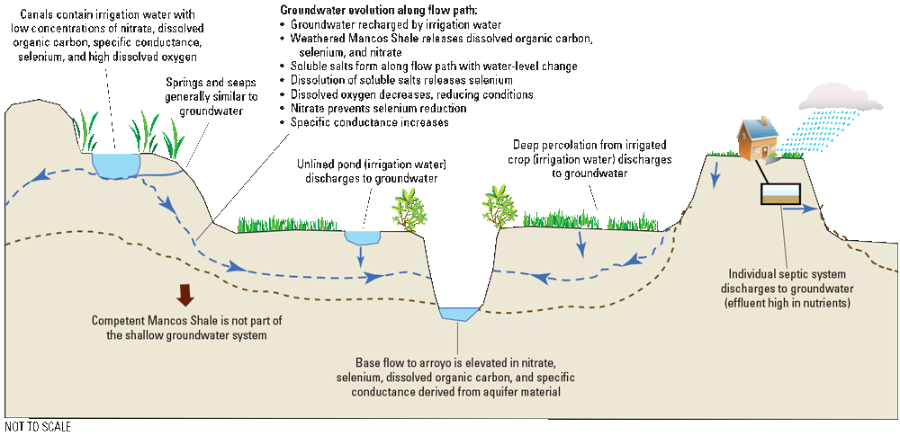
Conceptual diagram depicting the geologic source and mobilization and transport of selenium in the lower Gunnison River Basin (from Thomas and others, 2019).
Geologic Sources
The Mancos Shale is the primary geologic source of selenium to groundwater and surface water in the lower Gunnison River Basin. Seawater, volcanic ash, and pyrite are the primary original sources of selenium to the deposits of Mancos Shale (Byers and others, 1938; Davidson and Powers, 1959; See and others, 1991; Kulp and Pratt, 2004; Tuttle and others, 2014a, b), and in the unweathered shale, selenium is primarily associated with organic shale and pyrite (Tuttle and others, 2014a, b). The weathered shale and derived materials contain secondary weathering products of iron oxides and soluble selenium-bearing salts (Tuttle and others, 2014a, b). The soluble salts that have accumulated in the weathered zone through thousands of years (Tuttle and others, 2014a, b) are the most soluble forms of selenium in naturally weathered Mancos Shale and its derived materials (Mast and others, 2014).Taken together, the weathered and unweathered Mancos Shale could be an ongoing substantial nonpoint source of selenium to the Colorado River, and the present-day distribution of selenium within the Mancos Shale and its derived materials could provide useful information for selenium management in the lower Gunnison River Basin.
Mobilization
Selenium is mobilized from Mancos Shale and derived materials by natural weathering processes and human activity. In undeveloped natural areas, particulates of Mancos Shale can be mobilized to drainages and streams by wind and by local storms and precipitation. Land disturbance in developed areas caused by road construction, agriculture practices, oil and gas development, and residential and urban development can liberate particulates of Mancos Shale and increase wind and water mobilization of selenium. In areas underlain by Mancos Shale and its derived materials, application and deep percolation of water dissolves soluble selenium-bearing salts and related minerals from the unsaturated weathered zone, which can release selenium, sulfur, nitrogen, major ions, and other trace elements to the water table (Mast and others, 2014; Thomas and others, 2019; Mast, 2021). Human activities that apply water to the landscape include domestic water use (lawn irrigation, water infrastructure, and septic tank leachate), irrigation water application (flood and sprinkler irrigation), and irrigation water delivery and return flows (leaking canals, laterals, ditches, and ponds) (Thomas and others, 2019). Dissolved selenium also can be released directly to surface water by runoff, sediment transport, or present-day streams that are in contact with Mancos Shale and its derived materials (Bern and others, 2023).
Selenium-bearing salts in the lower Gunnison River Basin formed from the oxidation of pyrite in shale during thousands of years (Tuttle and others, 2014a, b), and there is little evidence of primary pyrite remaining from the original Mancos Shale in near-surface weathering environments (Mast and others, 2014). Laboratory experiments and geochemical modeling corroborate findings that selenium is primarily released from soluble salts and gypsum dissolution (Mast and others, 2014). In previously irrigated soils, soluble forms of selenium can be depleted (flushed) and most selenium is associated with organic matter that was stable in near-surface weathering conditions. Selenium is also released from previously irrigated materials, but at a much slower rate (Mast and others, 2014). High concentrations of extractable selenium and nitrate were measured in previously unirrigated soils and bedrock. Nitrate salts in previously unirrigated materials are derived from weathered organic matter in the original shale rather than from agricultural sources (Mast and others, 2014), indicating that there are natural sources of nitrate in the lower Gunnison River Basin. Nitrate in groundwater acts as an oxidizing agent and inhibits the reduction of selenium. Oxidized forms of selenium are more soluble than reduced forms, so the presence of nitrate contributes to elevated concentrations of selenium in water (Mast and others, 2014; Mills and others, 2016; Thomas and others, 2019). Sources of nitrate from human activity, such as synthetic fertilizers, could also contribute to elevated selenium concentrations in the lower Gunnison River Basin (Wright, 1995, 1999).
Transport
Selenium can be transported from source areas to receiving streams and biota by surface water, groundwater, and sediment. The major rivers in the lower Gunnison River Basin originate in the high mountains, where winter snowpack accumulation supports annual spring snowmelt and runoff that supplies surface water to lower elevations. The annual hydrograph is characterized by fall and winter base-flow conditions when streamflow is supported by groundwater discharge followed by the annual spring snowmelt and runoff in May or June (Schaffrath, 2012).
Some of the surface water from headwater parts of the basin is diverted by tunnels and canals to lower parts of the basin where it is distributed to irrigated areas by canals and ditches. In irrigated areas, the annual surface-water hydrograph is similar to the natural hydrograph, having a characteristic fall and winter nonirrigation (no irrigation) season base-flow condition but having spring runoff sustained for a longer period by irrigation return flows (surface water and deep percolation) through the summer irrigation season (Mast and others, 2014). Selenium concentrations in surface water are inversely related to flow, and the greatest selenium concentrations typically occur during the nonirrigation season when flows are lower and primarily due to groundwater discharge to the streams (Mast and others, 2014). About one-half of the annual selenium load to Loutsenhizer Arroyo and Sunflower Drain is estimated to come from groundwater base flow (Mast and others, 2014; Thomas and others, 2019).
The shallow groundwater system is supported by recharge (deep percolation) from streams, irrigation canals, irrigated fields, seasonal spring snowmelt, and infrequent summer thundershowers (Butler and others, 1996). On a regional scale, the Mancos Shale is not water bearing and is considered a confining unit rather than an aquifer because of its great thickness and low permeability (Lohman, 1965). Before the development of irrigation, shallow groundwater in the lower Gunnison River Basin was likely insubstantial (Reclamation, 1982; Butler and others, 1996). On a local scale, a small number of wells obtain water from unconfined groundwater that comes from the weathered zone of the Mancos Shale and (or) the alluvium that fills former arroyos in the Mancos Shale (Lohman, 1965; Butler and others, 1996). Data from a 30-well monitoring network installed on the east side of the Uncompahgre River have led to an increased understanding of the shallow groundwater system in the lower Gunnison River Basin (Thomas, 2015; Thomas and Arnold, 2015). Wells completed in alluvial sediment were unconfined, allowing groundwater to flow through unconsolidated material. Wells completed in Mancos Shale, however, were confined and recharge to the confined aquifer is likely along fractures and bedding planes (Thomas and others, 2019). Lithologic and groundwater-level data obtained during well installation were used to map the hydrogeology of the shallow groundwater system, including extent and thickness, consolidated bedrock surface, and potentiometric surface (Arnold, 2017). Study of the well network showed that the isotopic composition of the shallow groundwater system was similar to that of local rivers, indicating that groundwater is recharged by irrigation water. Additionally, groundwater ages ranged from 6 to 20 years (Thomas and others, 2019).
As groundwater moves from recharge to discharge areas, it transports dissolved constituents downgradient to receiving streams, drains, canals, and wetlands. Previous studies of groundwater quality in the lower Gunnison River Basin indicated that high calcium, sodium, sulfate, selenium, and dissolved solid concentrations in groundwater were ubiquitous in areas underlain by Mancos Shale (Butler and others, 1996). Previous study results also showed an inverse relation between groundwater levels and dissolved solid concentrations–the highest groundwater levels and lowest dissolved-solid concentrations occurred during the irrigation season (Butler and others, 1996). Irrigation recharge dominates the hydrologic system during the summer irrigation season, raising groundwater levels (Mills and others, 2016; Thomas and others, 2019; Mast, 2021), increasing streamflow, and diluting selenium concentrations in groundwater (Butler and others, 1996) and surface water (Mast and others, 2014; Mast, 2021).
Selenium-bearing sediment can be transported from natural areas by wind and water erosion. Erosion of steep slopes of Mancos Shale greater than 20 degrees, such as in arroyos and adobe hills, plays an important role in the transport of selenium and gypsum (Elliott and others, 2008; Tuttle and others, 2014a144, b). During erosion, salt and selenium are either removed in solid phases and transported to the valley floor as soil creep or entrained in runoff and wind. Schumm and Gregory (1986) provide a discussion of alluvial deposition of Mancos Shale material.
Fate of Selenium
The fate of selenium, once mobilized and transported, is of interest in the lower Gunnison River Basin because selenium bioaccumulation may prevent the recovery of endangered fish species. Diet is the primary pathway of selenium exposure for aquatic organisms (Luoma and Fisher, 1997; Luoma and Rainbow, 2005; Luoma and Presser, 2009; Chapman and others, 2010; Presser and Luoma, 2010120). In fish and birds, selenium accumulates in tissues and is maternally transferred to eggs (Luoma and Presser, 2009; Chapman and others, 2010). Reproductive impairment caused by maternal transfer results in embryotoxicity and teratogenicity, which are the primary results of selenium toxicity in fish (Chapman and others, 2010).
Selenium enters the food web and diet of consumers from water and particulates, and the factors linking water, particulates in water, and fish-tissue concentrations are an area of active research (Presser and Luoma, 2010; Presser, 2013; Jenni and others, 2017; Luoma and Presser, 2018; Presser and Naftz, 2020; Brandt and others, 2021). In the stream environment, selenium in water and sediment is chemically reduced in the presence of organic matter to bioavailable forms of selenium such as organic particulates, biofilms, and phytoplankton (Presser and Luoma, 2010). These reactions commonly occur at the sediment-water interface in biofilms such as periphyton on the streambed where dissolved selenium is bioconcentrated at the base of the food web through accumulation into phytoplankton, periphyton, or other organic matter (Presser and Luoma, 2010; Presser, 2013; Brandt and others, 2021). The bioavailable selenium is then bioaccumulated through macroinvertebrates to predator fish and birds (Presser and Luoma, 2010). The dissolved concentration of selenium in the water column is not necessarily a good indicator or predictor of selenium accumulation in or toxicity to fish, which highlights the need to evaluate fish recovery with selenium-toxicity studies of the food web in targeted locations (Presser and Luoma, 2010; Presser, 2013). In 2016, EPA updated the recommended national chronic aquatic life criterion for selenium, moving from a water-column basis to standards that include fish egg-ovary, whole body, muscle, and water-column concentrations (EPA, 2016).
Monitoring and Research Data Gaps
This section describes data gaps related to selenium in the lower Gunnison River Basin and types of monitoring and studies to potentially help fill those gaps. The text is organized by media following a source, transport, and receptor order of discussion: geologic sources, groundwater, surface water, sediment, biota, and best management practices (BMPs). Monitoring and research projects that support the SMP goals were outlined initially in the SMP formulation document (Reclamation, 2011) and annual reports (for example, app. B of Ward and others, 2021). The data gaps presented in this section include ongoing and potential additional research that could increase the understanding of selenium in the lower Gunnison River Basin and potentially support the SMP goals (table 2).
Table 2.
List of ongoing and potential additional research needs and monitoring to potentially address identified data gaps regarding selenium in the lower Gunnison River Basin.[Some of the work is ongoing by the U.S. Geological Survey (USGS). Activities not in progress are listed with “data gap” in the “Status” column, meaning the work could be done to address a specific question or concern. The “Timeline” column indicates the anticipated length of the project—short term (1–3 years) or long term (more than 3 years)]
| Research need | Status | Timeline | Comments |
|---|---|---|---|
| Geologic mapping | Data gap | Long term | Map quadrangles within the lower Gunnison River Basin and convert existing paper maps to geographic information system datasets. |
| Soil and core sampling and analysis of Mancos Shale members | Data gap | Short term | Use sequential extraction and column leach experiments to refine understanding of selenium distribution related to Mancos Shale members. May be useful in areas of new development on previously unirrigated Mancos Shale. Work is related to Mast and others (2014). |
| Updated regression models | Data gap | Long term | As they become available, incorporate new geospatial datasets in regression models (Linard, 2013; Williams and others, 2023169). |
| Groundwater characterization and well installation | Data gap | Long term | Install additional groundwater wells to aid in further characterizing the system. Wells could be installed to address site-specific data gap (for example, evaluating changes related to land use or best management practices). |
| Groundwater levels and well maintenance | Ongoing (USGS) | Long term | Measure groundwater levels and maintain wells in the 30-well network (Thomas, 2015; Thomas and Arnold, 2015140). |
| In situ remediation | Data gap | Long term | Explore the feasibility of in situ groundwater remediation or install a demonstration project for in situ removal of selenium from groundwater and monitor system performance. Work is related to Sottilare and Thomas (2018). |
| Selenium concentrations and tracers in groundwater near developed areas | Data gap | Long term | Characterize selenium concentrations and source indicators (tracers) in groundwater downgradient from areas undergoing urban and residential development. |
| Monitoring network | Ongoing (USGS) | Long term | Collect samples at sites in the surface-water monitoring network to track concentrations and loads through time. |
| Monitoring network annual trend report | Ongoing (USGS) | Long term | Use trend analysis at one or more core network sites to evaluate long-term changes in selenium concentration and load. Trend analysis might also be useful for Montrose Arroyo at East Niagara Street (site 382802107513301) and Sunflower Drain at Highway 92 (site 384551107591901) (USGS, 2021b). |
| Yield verification | Data gap | Short term | Sample to verify modeling results (Linard, 2013; Williams and others, 2023169) that could provide calibration data for additional model efforts. |
| Real-time estimates of selenium concentrations and loads | Ongoing (USGS) | Long term | Sample to update statistical regressions for estimating dissolved selenium concentration and load in real time. |
| Suspended sediment flux | Data gap | Long term | Collect suspended sediment samples to identify source areas and patterns of selenium on suspended sediment. |
| Modeling fate and transport of selenium on suspended sediment | Data gap | Short term | Model deposition patterns of suspended sediment and potential effects on aquatic life. |
| Selenium concentrations in fish tissue | Ongoing (USGS) | Long term | Collect muscle-plug samples and analyze selenium concentrations in tissues of endangered fish and surrogate species. |
| Mercury and selenium interactions in fish tissue | Data gap | Short term | Use existing data or collect muscle-plug samples to analyze selenium and mercury concentration in fish tissue and explore interactions between selenium and mercury concentrations and how selenium might mitigate the toxic effects of mercury. Work is related to Day and others (2020). |
| Timing of selenium exposure and transfer to upper trophic levels (fish tissue concentrations) and their prey (aquatic insects and small-bodied fish) | Data gap | Long term | Refine an ecosystem model for selenium partitioning and trophic transfer in the lower Gunnison River Basin. The refined model could be used to simulate water-column selenium concentrations that could be protective of fish health. Work is related to Brandt and others (2021). |
| Trends in selenium concentrations | Data gap | Short term | Use existing data to relate trends in dissolved selenium concentrations to trends in selenium concentrations in fish tissue and fish population estimates. |
Geologic Source Characterization
Characterization of geologic sources includes geologic mapping, soil studies, and geochemical characterization of geologic materials and soils. Geologic mapping and additional targeted studies of geologic sources are identified as data gaps. In addition, developing geospatial representations of the geologic sources of selenium could inform surface-water loading models for the lower Gunnison River Basin and spatial analysis for evaluating selenium-mitigation projects.
Geologic Mapping
The Mancos Shale underlies the Grand Valley at Grand Junction and irrigated valleys in the lower Gunnison River Basin. The Juana Lopez Member of Mancos Shale, Niobrara Member of Mancos Shale, and Smoky Hill Member of Niobrara Formation are recognized as selenium bearing (Tuttle and others, 2005, 2014a, b; Noe, 2010). The unweathered Juana Lopez contains selenium-bearing pyrite (Tuttle and others, 2014a, b), and weathered members and derived materials contain secondary selenium-bearing salts. Mapping of quadrangles in the lower Gunnison River Basin by the Colorado Geological Survey (Noe, 2010) has identified and delineated members of the Mancos Shale and their derived materials. About 18 percent of quadrangles within the lower Gunnison River Basin are published in geographic information system-ready format at the 7.5-minute scale (fig. 10; map status was obtained from the USGS National Geologic Map Database [USGS, 2021a]).
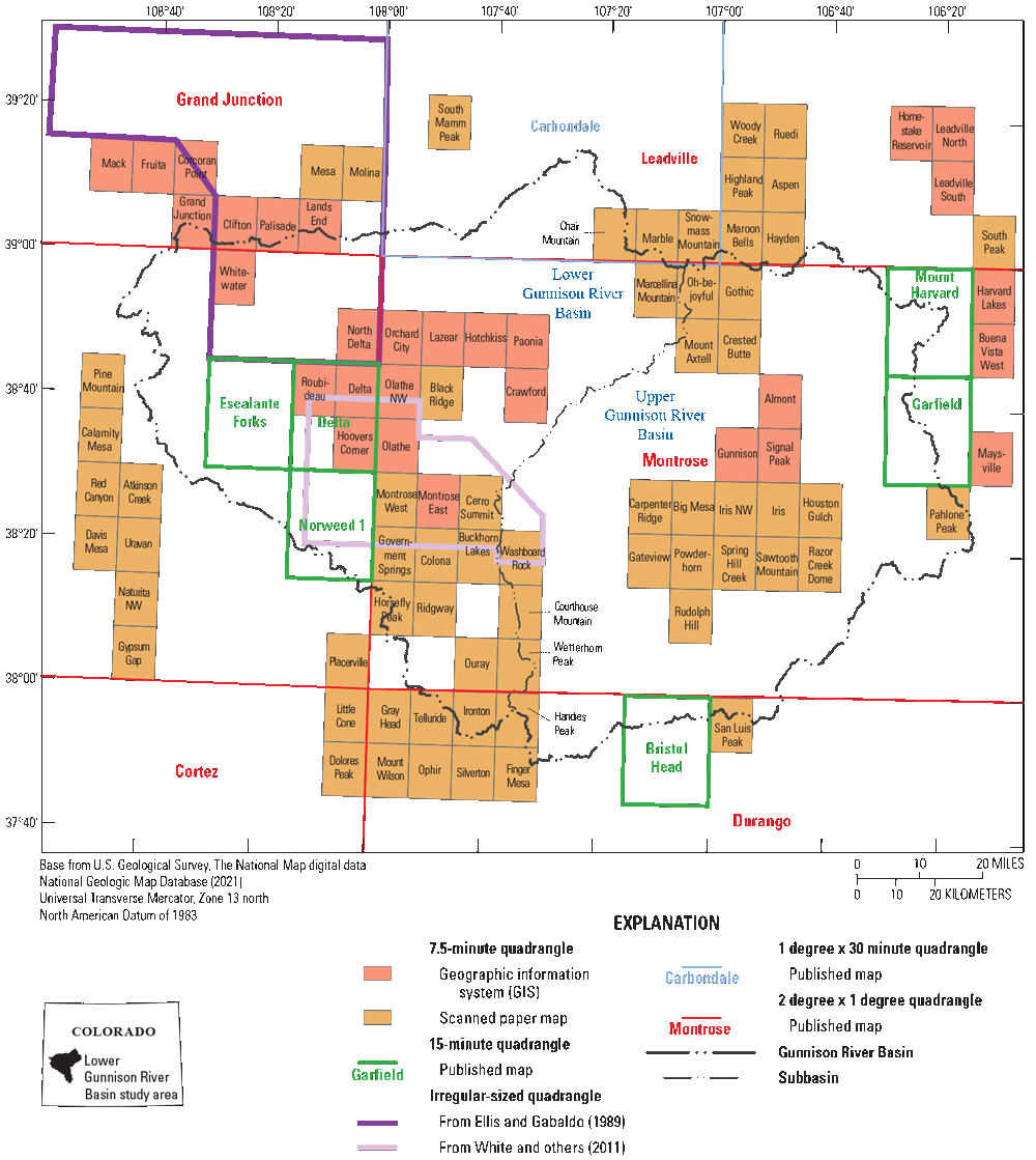
Map showing the status of geologic mapping for quadrangles in the lower Gunnison River Basin, Colorado, 2021. From Ellis and Gabaldo (1989), U.S. Geological Survey (2021a), and White and others (2011).
Soils
Soils have been studied in the lower Gunnison River Basin with respect to selenium (total and water extractable) occurrence and concentration. The NRCS collected soils derived from Mancos Shale for selenium analysis and collected a total of 211 soil samples at 44 locations in the lower Gunnison River Basin (Dearstyne and Brummer, 2005). Soluble selenium concentrations were found to be significantly higher in nonirrigated soils than in irrigated soils, indicating flushing of the soil-water system in irrigated areas (Dearstyne and Brummer, 2005). Similarly, work done near Delta and Montrose to characterize the distribution of selenium in soils derived from weathered Mancos Shale showed that the soils had high selenium content overall, but soluble selenium had been removed from topsoil by irrigation and soluble selenium concentrations generally increased with depth (Elrashidi, 2018).
The NRCS has developed a dataset for selenium leaching potential, which is based on the following soil and climate properties: parent material, soil pH, depth to bedrock, average annual precipitation, and depth and duration of water table (NRCS, 2014). The dataset can be used to develop a map of potential selenium leaching potential levels ranging from low to very high. In the lower Gunnison River Basin, soils with high or very high comparative rankings are primarily east of the Uncompahgre River (fig. 11). The dataset is available through the NRCS Web Soil Survey (Natural Resources Conservation Service, 2014).
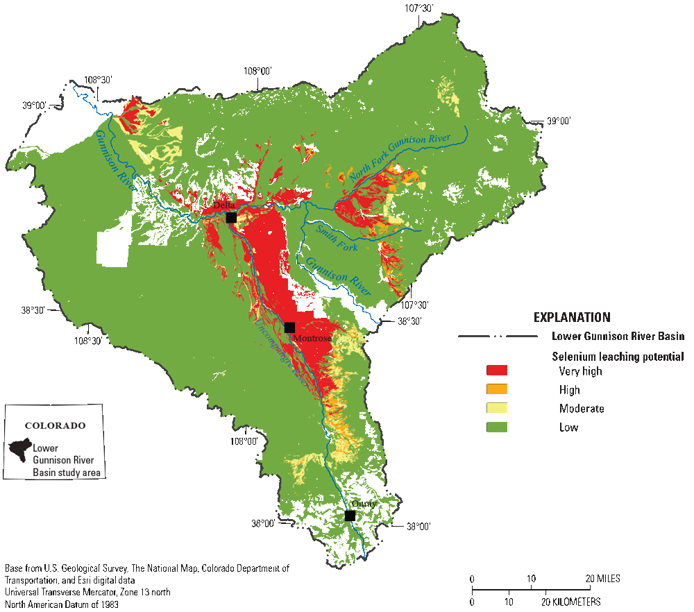
Map showing selenium leaching potential for soils in the lower Gunnison River Basin, Colorado. The selenium leaching potential dataset is available through the Natural Resources Conservation Service Web Soil Survey (Natural Resources Conservation Service, 2014).
Geochemical Characterization of Mancos Shale and Derived Materials
Studies of selenium in the Mancos Shale weathered zone and soils have contributed to the conceptual model of selenium release and mobilization in the lower Gunnison River Basin. Such studies are discussed in Dearstyne and Brummer (2005), Mast and others (2014), Tuttle and others (2014a, b), Mills and others (2016), and Thomas and others (2019). Refer to the “Conceptual Model of Selenium Occurrence in the Lower Gunnison River Basin” section of this report for additional information on these studies.
In the unweathered shale, selenium is associated with organic shale and pyrite (Tuttle and others, 2014a, b). In the near-surface weathered shale and derived materials, secondary weathering products of iron oxides and soluble selenium-bearing salts are geologic sources of selenium (Tuttle and others, 2014a, b). Soluble salts, which have accumulated in the weathered zone and soils through thousands of years (Tuttle and others, 2014a, b), are the most soluble forms of selenium in naturally weathered Mancos Shale and its derived materials (Mast and others, 2014). These soluble salts are readily available for dissolution by groundwater and surface water, especially in previously unirrigated areas (Mast and others, 2014).
The weathered and unweathered Mancos Shale could be a substantial ongoing, nonpoint source of selenium to the Colorado River, and further study of the distribution of selenium within the Mancos Shale and its derived materials could provide useful information for selenium management in the lower Gunnison River Basin. The differences in the solubility and bioavailability of the different forms of selenium allow sequential-extraction methods to be used to quantify the speciation of selenium in operationally defined fractions (Kulp and Pratt, 2004; Mast and others, 2014). Sequential extraction results from cores collected to the east of the Uncompahgre River indicated that soluble salts represented only a small part of the total selenium in cores (Mills and others, 2016). The oxidation and mobilization of insoluble selenium in organic matter and selenide could provide selenium sources in addition to soluble salts; understanding the potential oxidation rates could provide information about additional sources (Mills and others, 2016).
Geologic Source Characterization—Potential Areas of Study
To increase the coverage and utility of geologic maps, additional quadrangles could be mapped, and paper maps could be converted to geographic information system datasets. Mapping could help to delineate Mancos Shale members in areas characterized as undifferentiated Mancos Shale (fig. 6).
Further characterization of the geologic sources of selenium in the lower Gunnison River Basin could benefit from sequential extraction and column leach tests on a broader suite of soil samples reflecting a range of geology, soil type, and land use (irrigated compared to nonirrigated). Samples could be collected from irrigated and nonirrigated areas representative of soils and materials from various Mancos Shale members and soil types. Sampling in previously unirrigated areas slated for residential development could improve understanding of selenium release from soils converted from unirrigated to irrigated land use. Column leaching experiments could be completed on selected soil profiles to investigate the effects of land use and parent material on selenium release rates from soils. The objective of this characterization work is to better understand the occurrence and distribution of selenium in near-surface weathered Mancos Shale and its derived soils. Ultimately, this information could be used as input for models and to improve understanding of additional selenium sources.
Results from geochemical characterization work (Mast and others, 2014; Tuttle and others, 2014a, b; Mills and others, 2016) could be mapped and compared to other available data layers such as geology, irrigated lands, topography, and soil properties to help explain spatial variations in near-surface selenium content. Geostatistical methods could be used to relate selenium concentrations to other datasets for use in regression models that relate basin characteristics to selenium concentrations in streams (for example, Leib and others, 2012; Linard, 2013; Williams and others, 2023).
Groundwater
In 2012, the USGS began to design and implement a 30-well regional groundwater-monitoring network on the east side of the Uncompahgre River in irrigated areas underlain by Mancos Shale (Thomas, 2015; Thomas and Arnold, 2015). The entire 30-well network (fig. 12) was sampled during the irrigation season in 2014 and during the nonirrigation season in 2015 to evaluate regional groundwater conditions (Thomas and others, 2019), and cores collected during the monitoring well installation were used for geochemical source characterization (Mills and others, 2016) and hydrogeologic mapping (Arnold, 2017). As of 2021, one well in the network had been destroyed and another was no longer accessible. In addition to the 30-well network, a total of 4 wells (2 paired wells) were installed in 2012, adjacent to a leaky canal near Olathe, Colo. (Linard and others, 2017). Multiple studies have contributed to the understanding of groundwater and its role in selenium mobilization and transport in the lower Gunnison River Basin (for example, Butler and others, 1996; Mast and others, 2014; Mills and others, 2016; Arnold, 2017; Thomas and others, 2019; Mast, 2021; refer to the “Conceptual Model of Selenium Occurrence in the Lower Gunnison River Basin” section of this report). However, the system is complex and could be better defined through additional study.
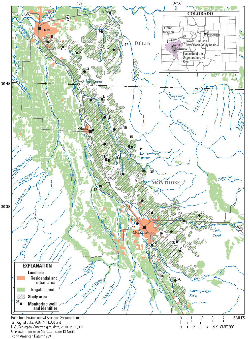
Map showing locations of wells in the 30-well groundwater-monitoring network on the east side of the Uncompahgre River as of 2019. Land use data from Colorado’s Decision Support System (2013). Figure from Thomas and others (2019).
The USGS investigated interactions between surface water and groundwater in Sunflower Drain, an agricultural drainage near Delta (Mast, 2021). Results indicated that groundwater inflow in the study reach is likely focused rather than diffuse and could be related to the distribution of irrigated land and features such as tile drains. The project also involved three pilot studies for techniques to investigate groundwater discharge to surface water: (1) fiber-optic distributed temperature sensing to detect groundwater discharge zones, (2) radon-222 as a geochemical tracer of groundwater discharge, and (3) passive seismic technique to estimate depth to bedrock; these methods all showed promise for investigating groundwater discharge to surface-water systems (Mast, 2021).
Groundwater Potential—Areas of Study
Additional well installation and groundwater system characterization could be done in the lower Gunnison River Basin. The groundwater system is complex, and characterization includes identifying the extent of saturated conditions (aquifer geometry or framework), sources and rates of recharge, groundwater-flow directions, aquifer properties, and areas of groundwater discharge. The USGS has developed maps depicting the base of alluvial aquifer materials, saturated thicknesses, and the water table for parts of the lower Gunnison River Basin using available data, including information from the 30-well monitoring network (Arnold, 2017). Fiber-optic distributed temperature sensing, radon-222 geochemical tracer, and horizontal to vertical spectral ratio passive seismic methods could be used to improve understanding of groundwater flow and recharge, allowing for application of groundwater flow models and improved understanding of the connections between groundwater and surface water throughout the lower Gunnison River Basin.
Long-term monitoring at groundwater wells could provide insight to changes in the groundwater level and water quality in response to SMP projects. Results from studies and monitoring within the regional surface water and groundwater network may indicate specific areas in the lower Gunnison River Basin where site- or situational-specific groundwater studies may be needed. Site-specific monitoring or modeling could be used to evaluate implementation of BMPs in the lower Gunnison River Basin such as canal lining, changes in land use, or conversion from flood to sprinkler irrigation. Studies to address these site-specific data gaps could be considered on a project-by-project basis as the SMP implementation proceeds.
Surface Water
The USGS and other entities routinely sample surface water in the lower Gunnison River Basin. The sampling includes a variety of measurements and analytes, including streamflow, dissolved selenium, and other inorganic chemical analyses. The SMP workgroup coordinates sampling with partners such as USGS, CDPHE’s Colorado Water Quality Control Division, and State and local entities to ensure uniformity and data comparability. The monitoring may differ by sampling agency and station depending on individual site objectives, some of which may address objectives outside the scope of the SMP. Refer to the SMP formulation document (Reclamation, 2011) for additional information on coordination with partners.
The SMP surface-water monitoring network consists of USGS sites located primarily on the main-stem of the Gunnison River, North Fork of the Gunnison, and Uncompahgre Rivers with additional sites on several larger tributaries (fig. 2). Sites in the surface-water network have been strategically placed to account for concentrations and loads of dissolved selenium and other constituents from six major contributing areas (CAs) to the lower Gunnison River Basin. Data collected through the monitoring program supplement a database that provides the basis for statistical analysis at various scales (for example, refer to Henneberg, 2016, 2018, 2020; Henneberg and others, 2021). Data are stored in the USGS National Water Information System database at https://doi.org/10.5066/F7P55KJN. The monitoring network includes both core and ancillary sites (table 1; figs. 2, 6). Core sites have USGS streamgages; ancillary sites do not. The list of ancillary sites may change annually as data gaps are filled, operations change, and cooperator research is completed.
Additional sampling of rivers and streams in the lower Gunnison River Basin is done by the CDPHE. The CDPHE sampling does not usually include streamflow measurements, which limits the utility of the data for load calculations; however, some of the data are collected at USGS streamgages and have associated streamflow measurements that can be used for load calculations. The data collected by CDPHE primarily aid in the determination of instream concentrations for State regulatory purposes, and the data are useful for determining dissolved selenium and other constituent loads from the six major CAs (refer to the following section, “Contributing Areas”).
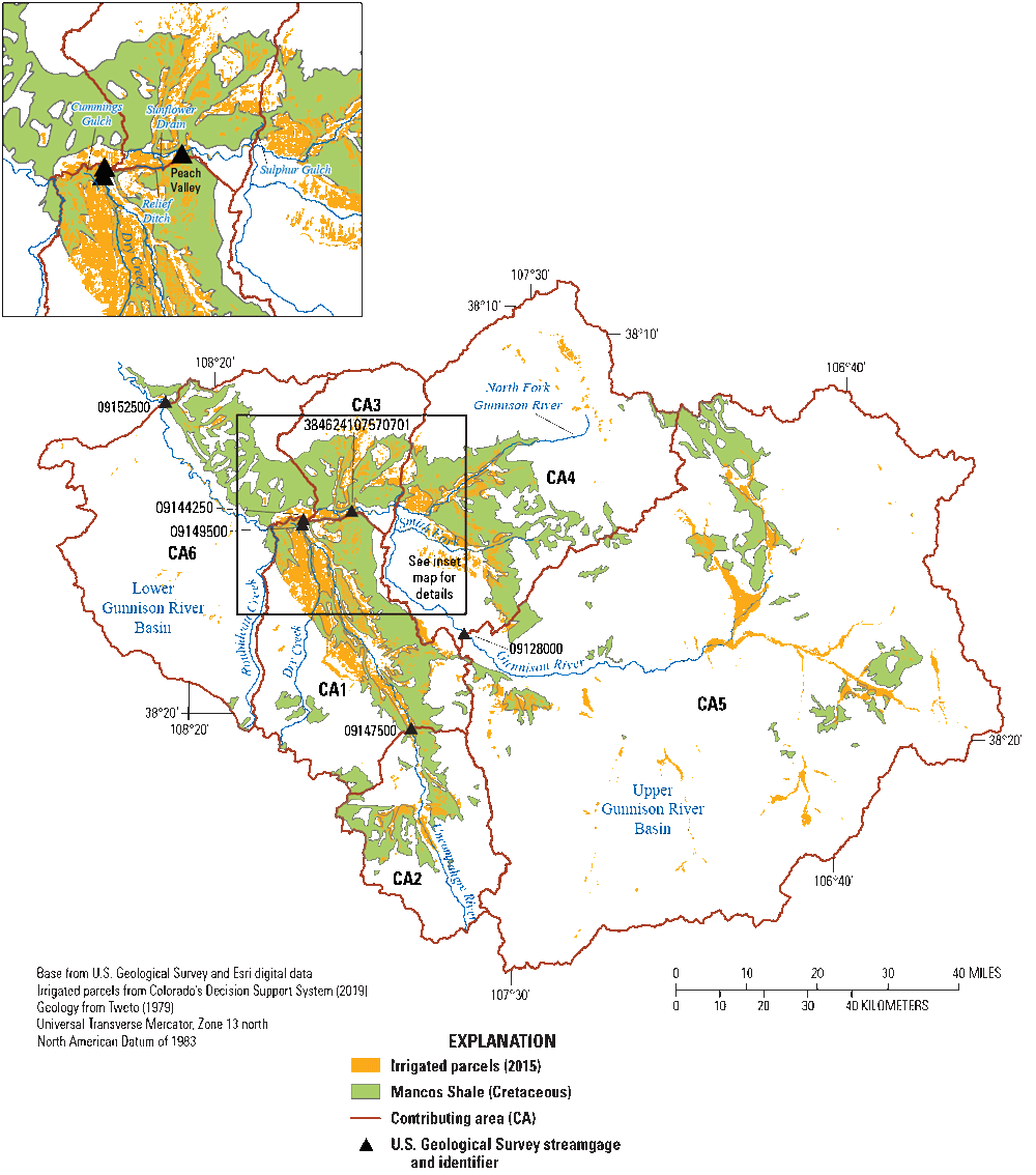
Contributing Areas
The six major CAs in the Gunnison River Basin (table 3, fig. 13) each represent a CA to the USGS streamgage site Gunnison River near Grand Junction, Colo. (USGS streamgage site number 09152500; USGS, 2021b), which is used by the CDPHE as the outflow site for the entire Gunnison River Basin. The CAs are primarily based on basin boundaries and are similar to those described by Reclamation in 2006 to estimate selenium loading from different parts of the Gunnison River Basin (Reclamation, 2006); however, some modifications were made to represent surface-water drainage areas more accurately.
Table 3.
Contributing areas to the U.S. Geological Survey streamgage Gunnison River near Grand Junction, Colorado (streamgage site number 09152500; USGS, 2021b).[CAs are modified from Reclamation (2006); Irrigated acres determined from Colorado’s Decision Support Systems (2019); acres of Mancos Shale determined from Tweto (1979)]
Map showing contributing areas (modified from Reclamation, 2006) used for calculating loads and trends for the lower Gunnison River Basin. Contributing areas CA1, CA2, CA3, CA4, and CA6 make up the lower Gunnison River Basin; CA5 is the upper Gunnison River Basin. Streamgage numbers from USGS (2021b).
CA1 is the Uncompahgre Project area and includes the Uncompahgre River Basin combined with the Peach Valley and Sunflower Drain areas to the north and east and Cummings Gulch and Roubideau Creek to the west. The Uncompahgre Project is a Reclamation water-supply project that involves diversion dams, canals, and other infrastructure to move water from the Uncompahgre and Gunnison Rivers to irrigated land in the Uncompahgre Valley (Reclamation, 2023). The area for CA1 used herein is modified from Reclamation (2006) by removing areas upstream from USGS streamgage site number 09147500 (fig. 13). The change was made to better represent the contribution of selenium load from the Uncompahgre Project, because areas upstream from streamgage site number 09147500 do not use Uncompahgre Project water for irrigation (Reclamation, 2023).
Three CAs are defined in the northern and eastern parts of the Gunnison River Basin. CA3 drains areas primarily to the north of the Gunnison River from the Dry Creek drainage east to Sulphur Gulch. A relatively small area to the south of the Gunnison River served by the Relief Ditch is also included in CA3. CA4 is the drainage area for the North Fork of the Gunnison River, the Smith Fork of the Gunnison River, and several small tributaries. CA5 is the upper Gunnison River Basin, and it constitutes the area upstream from USGS streamgage site number 09128000, Gunnison River below Gunnison Tunnel, Colo. (USGS, 2021b). Dissolved selenium concentrations have generally been below 1 µg/L at this site (Henneberg, 2020).
CA6 is downstream from most of the irrigated land in the Gunnison River Basin and is the least irrigated of the CAs (table 3). This area is distinguished from the other CAs because there is extensive drainage from nonirrigated selenium-bearing rocks and soils, providing contrast with the other areas and perhaps insight into predevelopment conditions for irrigated basins with a similar geologic and hydrologic setting.
Agricultural lands in the lower Gunnison River Basin can be categorized as irrigated and nonirrigated. Irrigated land receives irrigation water transported from other parts of the basin by tunnels, canals, and ditches (Reclamation, 1982). Nonirrigated land receives native precipitation as its only source of applied water. The distinction between irrigated and nonirrigated land is important because irrigated Mancos Shale and derived materials tend to have higher leaching rates of soluble selenium phases compared to nonirrigated materials (Mast and others, 2014).
Field irrigation is the primary agricultural use of imported water in the lower Gunnison River Basin. Land management agencies refer to irrigated land used to grow crops and land used for stock ponds as “on-farm usage” of water, and canal and lateral usage is referred to as “off-farm usage” (Reclamation, 2011). Some common nonagricultural uses of irrigated land include residential neighborhoods, ponds, and recreational areas such as parks and golf courses (Reclamation, 2011). Ponds are considered irrigated land and can be classified as existing for agricultural or nonagricultural uses. Nonagricultural irrigation in the lower Gunnison River Basin could increase as population and residential areas expand. As population grows and development occurs in previously unirrigated areas, the dissolved selenium load from nonagricultural sources could increase (Moore, 2011; Reclamation, 201114; Richards and Moore, 2015).
Stevens and others (2018) studied selenium loading in the reach of the Gunnison River between Delta and Grand Junction (CA6) and found that 5 percent of selenium load was potentially contributed by groundwater inflow. It is possible that some of the dissolved selenium contribution to CA6 may be from nonagricultural land use in and around Delta.
Trends in the Lower Gunnison River Basin
Downward and upward trends in dissolved selenium have been observed and documented at surface-water sites in the lower Gunnison River Basin. Mayo and Leib (2012) reported downward trends in dissolved selenium concentration and load at USGS streamgage site number 09152500 (fig. 13). Specifically, there was a 28.6-percent decrease in selenium load for the period 1986–2008. The downward trends in selenium concentration and load at this site have continued, and the load decreased from 22,400 pounds in water year 1986 to 12,100 pounds in water year 2019, a 46.2-percent reduction (Henneberg and others, 2021). A water year is the 12-month period from October 1 through September 30 of the following year and is designated by the calendar year in which it ends.
In contrast, Moore (2011) reported upward trends in dissolved selenium concentrations and loads in Montrose Arroyo near the confluence with Cedar Creek from 1992 to 2010. Moore (2011) documented changes in land use from unirrigated desert and irrigated agricultural to urban and hypothesized that development on previously unirrigated land may be contributing to the upward selenium concentration trend. Other possible causes of the increasing selenium include the development of golf courses, parks, and ponds as part of urban development on previously irrigated agricultural land, or changes in groundwater geochemistry (oxidation states) possibly caused by fluctuations in the water table. The second phase of the study (Richards and Moore, 2015) included data through 2013 and indicated that selenium loads at the mouth of Montrose Arroyo were no longer increasing and had decreased to levels previously observed by Butler (2001). Richards and Moore (2015) also observed decreases in selenium in a small tributary of Montrose Arroyo, which they attributed to the conversion of previously irrigated agricultural land to residential (urban land use) development.
Thomas and others (2013) documented upward trends in selenium concentration at two sites in CA1 (Uncompahgre Project). An upward trend was observed at USGS streamgage site number 383946107595301 (figs. 12 and 13), Loutsenhizer Arroyo below North River Road near Delta, Colo., for the period 1991–2009. This site receives surface water from an extensive irrigated area and is minimally populated relative to Montrose Arroyo. An upward selenium-concentration trend was also reported for USGS streamgage site number 09149500, Uncompahgre River at Delta, Colo., for the period 2002–2009 (Thomas and others, 2013; fig. 13). Extensive canal and lateral piping changes made by Reclamation and the Uncompahgre Valley Water Users Association and on-farm irrigation system improvement programs by the NRCS have been implemented in the basin (Schaffrath, 2012). The upward trend therefore could be caused by other, unaccounted for, increases in dissolved selenium load offsetting the selenium reduction efforts. In addition, selenium may be responding differently than salinity to system improvements such as canal and lateral piping and on-farm system improvements. This is shown by the downward trend in salinity at the streamgage site Uncompahgre River at Delta, Colo. (Schaffrath, 2012), in contrast to the upward trend in selenium (Thomas and others, 2013). Since the early 2000s, selenium concentration and load have decreased in Sunflower Drain, an agricultural drainage near Delta, and the changes were attributed to canal piping and on-farm improvements (Mast, 2021). However, Mast (2021) also observed that selenium and salinity trends were quite different in that salinity was no longer decreasing in Sunflower Drain.
Statistical Modeling of Dissolved Selenium Loads
Statistical models using linear regression to relate basin and land-use characteristics to salinity and selenium concentrations and loads have been used to rank subbasins in the lower Gunnison River Basin with respect to salinity and selenium yield (Leib and others, 2012; Linard, 2013). The most recent models use geospatial information to estimate annual dissolved selenium and selenium loads and yields from subbasins in the lower Gunnison River Basin (Williams and others, 2023). Unlike previous models (Leib and others, 2012; Linard, 2013), the newer models use adjusted loads to avoid nesting of subbasins, allowing for more accurate load computations (Williams and others, 2023). The selenium model relates physiographic, irrigation, soils, and land use information to surface-water selenium concentrations at USGS sampling sites using multiple linear regression techniques. The regression equations were used to estimate selenium loads for subbasins, and loads were converted to yields to produce a raster map of predicted yields (fig. 14). The yield prediction raster can be used to compute yield for user-defined polygons within the lower Gunnison River Basin.
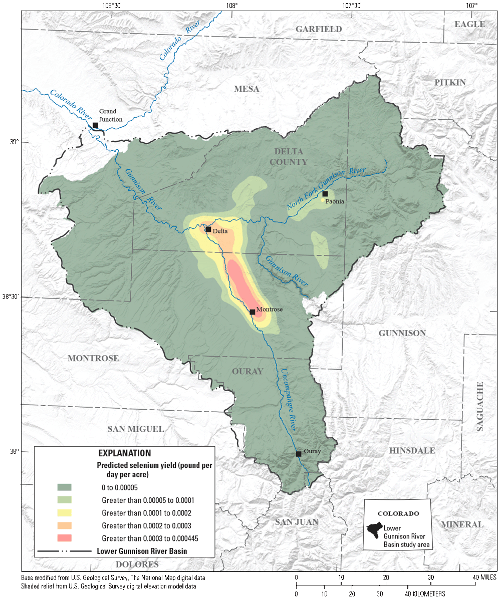
Map showing predicted dissolved selenium yield for the lower Gunnison River Basin (from Williams and others, 2023).
Real-Time Dissolved Selenium Loads
To assist with trend monitoring and statistical analyses, continuous water-quality monitors have been deployed at six locations in the lower Gunnison River Basin (table 4; sites 1–6 on fig. 2). These monitors provide long-term information that supports understanding of temporal fluctuations in selenium concentrations and loads (for example, Henneberg and others, 2021). The monitors, which are co-located with USGS real-time streamflow stations, measure data types such as temperature and specific conductance.
U.S. Geological Survey sites with continuous water-quality monitors in the lower Gunnison River Basin, 2022.
[Site information is from U.S. Geological Survey (2021b). CO, Colorado; Fk, Fork; nr, near; blw]
[Site information is from U.S. Geological Survey (2021b). CO, Colorado; Fk, Fork; nr, near; blw]
| Map identifier (core sites on fig. 2) | Site number | Site name | Parameters measured by continuous monitor |
|---|---|---|---|
| 1 | 09152500* | Gunnison River near Grand Junction, CO | Specific conductance, temperature, streamflow computed selenium, computed dissolved solids |
| 2 | 09136100* | North Fk Gunnison River above mouth nr Lazear, CO | Specific conductance, temperature, streamflow, computed selenium |
| 3 | 09144250* | Gunnison River at Delta, CO | Specific conductance, temperature, streamflow, computed selenium |
| 4 | 09147500* | Uncompahgre River at Colona, CO | Specific conductance, temperature, streamflow, computed selenium |
| 5 | 09149500* | Uncompahgre River at Delta, CO | Specific conductance, temperature, streamflow, computed selenium |
| 6 | 383946107595301 | Loutsenhizer Arroyo blw North River Road near Delta, CO | Specific conductance, temperature, streamflow |
Real-time selenium estimates were available for this site from the USGS National Real-Time Water Quality website (https://nrtwq.usgs.gov/).
Increased interest in real-time monitoring of salinity and selenium in the Colorado River Basin led to the use of multiple linear regression models to relate continuously measured streamflow and specific conductance to measured salinity (total dissolved solids) and selenium concentrations (Mayo and Leib, 2012; Linard and Schaffrath, 2014). The application of real-time selenium-concentration models at five of the six continuous monitors in the lower Gunnison River Basin began in January 2014 (table 4). Real-time estimates of selenium concentrations were available from the USGS National Real-Time Water Quality website (https://nrtwq.usgs.gov/). Real-time estimates can be a useful tool for tracking daily and seasonal variability of dissolved selenium concentrations and loads and to identify the response of dissolved selenium to activities or natural phenomena, such as development, water management, and snowmelt runoff. A better understanding of the response of dissolved selenium to human and natural activity could increase the SMP’s understanding of causes of variations in dissolved selenium in critical habitat.
Surface Water—Potential Areas of Study
Long-term monitoring of dissolved selenium concentrations during years or decades at core sites (sites 1–6 listed in table 1) could help increase the understanding of possible effects of selenium-control projects in the lower Gunnison River Basin. Long-term monitoring could also be helpful to understand the effects of other changes (such as extended drought). Several summaries of load and concentration data from sampling sites in the network have been completed to track sources and standard exceedances of dissolved selenium (Henneberg, 2016, 2018, 2020; Henneberg and others, 2021). Some of the sites (sites 7–10) in table 1 are not core sites but are referred to as “ancillary sites” by the SMP (Reclamation, 2011). The designation of site type has been flexible, meaning that old sites can be discontinued, and new or former sites can be sampled as needed, allowing the monitoring network to be updated as research priorities change.
As part of the load and concentration summaries, trend analysis is completed for the streamgage site number 09152500 (Henneberg, 2016, 2018, 2020; Henneberg and others, 2021). In addition to this site, trend analysis could be completed for other core sites in the monitoring network (table 4), streamgage site number 382802107513301, and streamgage site number 384551107591901. Analysis of data from these additional sites could provide new information to possibly determine if and where selenium levels are changing, and such changes might help indicate how land use or environmental changes are affecting selenium concentrations.
As additional information from monitoring and studies becomes available, existing selenium regression models (Williams and others, 2023) could be updated or recalibrated with new datasets. New datasets related to geology, soils, and geochemical characterization, as well as groundwater characterization and water-quality data generated from the 30-well groundwater-monitoring network (fig. 12) (for example, depth to the water table and groundwater selenium concentrations), also may prove useful for developing new statistical models for the lower Gunnison River Basin.
Simulations of additional scenarios using the existing model (Williams and others, 2023) could be evaluated using new geospatial datasets for existing model parameters as they become available. For example, the selenium model uses the wetted area of unlined irrigation channels in the subbasin as a geospatial input parameter (Williams and others, 2023). If a new geospatial dataset for unlined irrigation channels was available, the new dataset could be evaluated for use with the model to calculate selenium loads. Different scenarios for wet and dry years (different average annual precipitation rates) also might be used to evaluate how the system might respond. This model scenario testing could assume that statistical relations among geospatial parameters remain the same as the published model and could evaluate variability in selenium loads based on new parameter datasets. The validity of using the existing model with input parameter datasets different from those used to develop the model (model calibration) may require additional evaluation, but using an existing model may be more straightforward than developing new model calibrations.
Field verification of modeling results at targeted locations could be another means to quantify selenium loads from different subbasins and thus land uses. For example, model estimates could be verified by comparing model results to surface-water sampling results for ancillary sampling sites. Subbasins representing one predominant land use, such as residential or irrigated agriculture, could be sampled and the results compared to modeling results. Targeted field verification of modeling results for selected subbasins and land uses could help minimize the scope of field studies potentially needed to estimate loads from a variety of land uses. Field-verification sampling also could serve as a beneficial data source for additional model calibration efforts.
The equations used to estimate dissolved selenium concentrations and loads could be evaluated periodically (perhaps every 2 years) for relevancy because correlations at these sites may be changing with changing concentration trends (Mayo and Leib, 2012; Henneberg and others, 2021). This effort could rely on data collection at each site to potentially serve as additional calibration or verification datasets. The real-time estimates of selenium could also be useful as benchmarks for comparison to future selenium levels if the equations are not updated. Comparisons of how far the actual selenium values deviate from the estimates (often referred to as “residuals”) could be informative when trying to assess trend direction and magnitude.
Sediment
Fluvial sediment is often thought of as a physical condition of the stream system, but it also can affect chemical or toxicological characteristics in the aquatic ecosystem. Owing to a combination of physical and chemical processes, along with aquatic physiochemical conditions, fluvial suspended sediment and streambed sediment are both sources of and vectors for inorganic constituents and nutrients (Horowitz, 2008a, b). Solid-state transport of trace elements, such as selenium, is common and can occur at concentrations of orders of magnitude greater than those within the dissolved phase of the water column (Horowitz, 2008a).
Sediment derived from the physical weathering of surficial rock and soil may retain selenium from within the crystalline lattice structure of minerals. Additional retention can occur along or near the surface of particles where selenium complexes are held by sorption or complexation reactions with unbalanced surface charges. These unbalanced surface charges can be caused by clay mineralogy or surface coating of either organic matter or iron and manganese oxides and oxyhydroxides (Förstner and Wittmann, 1981; Förstner, 1989; Horowitz, 1991; Foster and Charlesworth, 1996). Changes in reduction-oxidation potential (Eh) and pH can cause changes in the properties of organic matter and iron and manganese oxides that can result in either additional sorption or desorption of selenium to or from these surface coatings (Horowitz, 1991; Foster and Charlesworth, 1996).
Knowledge of selenium on fluvial sediment is limited in western Colorado and is often based on assessments of Federal Irrigation Project Areas (hereafter, Federal Project Areas [FPAs]) such as the Uncompahgre, Grand Valley, and Dolores FPAs (Butler and others, 1995, 199619). Concentrations of selenium on sediment in the Grand Valley and Uncompahgre FPAs are elevated in comparison to upstream selenium concentrations on bed sediment (Vaill, 2000; table 5). Analysis of bed sediment in the Grand Valley and Uncompahgre FPAs showed that, of the total selenium, less than 1 percent is soluble and between 2.5 and 16.9 percent is surface sorbed. Speciation of the selenium (soluble and sorbed) on the bed sediment showed that, at most sites, most of the selenium was not selenite (Butler and others, 1996). This result is unlike findings from Fujii and others (1988) whose samples from the San Joaquin Valley in California showed that most of the soluble and sorbed selenium was selenite. This contrast may indicate that geochemical processes or soil chemistry in the San Joaquin Valley differ from those in the lower Gunnison River Basin.
Table 5.
Summary of selenium concentrations on streambed sediment in the Grand Valley and Uncompahgre Federal Irrigation Project Areas, Colorado.[Soluble selenium was liberated from sediment through digestions using potassium chloride; sorbed selenium was liberated from sediment through digestions using potassium chloride and potassium phosphate (Fujii and others, 1988). ppm, parts per million (equivalent to micrograms per gram); --, not available]
Data from Vaill (2000).
Data from Butler and others (1996).
Because of the potential reactiveness of selenium sorbed to surface coatings, and the hypothesis that these forms of selenium are more readily available, the term “available selenium” can be used to describe them. The selenium that is retained from the parent material within the lattice structure is less reactive and is referred to as “total extractable selenium” and is quantified by chemical digestions of the minerals and laboratory analysis (for example, Fujii and others, 1988). The differing reactivity of these two states of selenium affects the relative solubility, bioavailability, and toxicity of selenium to organisms. However, differing laboratory analysis methods used to target the soluble, sorbed, and total forms of selenium can produce inconsistent results, and a direct toxicity assessment may be a better means to identify the environmental importance of these concentrations (Tessier and others, 1979; Chao, 1984; Horowitz, 1991, 2008b; Hall and others, 1996).
Comparisons of suspended-sediment flux between the USGS streamgage at Colorado River near Cisco, Utah (09180500; USGS, 2021b), and key upstream locations can be used to evaluate potential selenium from source areas. Findings from Horowitz and others (2001) demonstrate that, in water years 1996 and 1998, as much as 72 percent of the annual load of selenium at the site Colorado River near Cisco, Utah, was in the filtered phase and 28 percent of the total load was measured in the solid phase (sediment). In a wet year (water year 1997), the percentage in solid phase increased to 46 percent, and there was only a small increase in the dissolved selenium load (18 tons in 1996 and 1998, 19 tons in 1997). Specifically, the sediment load ranged from 4.0 to 4.2 million tons (1996 and 1998, respectively) to 9.8 million tons in water year 1997. During 2015–17, USGS measured selenium on suspended sediment at selected sites in the lower Gunnison River Basin in critical habitat for endangered fish species (table 6). The goal was to investigate the role of sediment as a selenium load vector in surface water, including tributaries, where the particulate transport of selenium was largely uncharacterized in the lower Gunnison River Basin. Results showed that selenium concentrations on suspended sediment did not differ greatly, but slightly increased upstream from the site Gunnison River near Grand Junction, and concentrations were slightly higher in tributaries (Sunflower Drain and Loutsenhizer Arroyo) than in the main-stem Gunnison and Uncompahgre Rivers (table 6) (data from the USGS National Water Information System database; USGS, 2021b).
Table 6.
Summary of selenium concentrations on suspended sediment at selected sites in the lower Gunnison River Basin, 2015–17.[Data are available through the U.S. Geological Survey National Water Information System database (USGS, 2021b). CO, Colorado; blw, below; N., North; nr, near; ab, above]
Increases in the surface area of a particle provide increased capacity for sorbed trace elements such as selenium (Horowitz, 2008b). For most sediment particles, surface area per mass increases as particle size decreases. This is especially true for platy particles such as clays where the surface areas are 1,000 times greater than those for the same mass of sand (Black, 1957). Particle size can affect sorbed chemistry concentrations, wherein concentrations increase as particle size decreases (Förstner and Wittmann, 1981; Horowitz, 1991). The enrichment of selenium on fine sediment has not been shown to be substantial in the study area. However, targeting only one specific particle size of suspended sediment, typically based on the separation of silt and clay (less than 0.0625 microns) and sands (0.0625 microns to 2 millimeters), may not be appropriate (Horowitz, 2008b). Understanding the specific particle size is important because there are typically substantial differences in the concentrations for each particle size and the locations where the sediment is deposited.
The importance of characterizing the role of sediment in the lower Gunnison River Basin is further stressed by deficiencies in the conventional assessments of total selenium using whole water (unfiltered) samples. The issue with this type of assessment is related to the quantity of sediment within the water sample and the laboratory reporting limit of the analysis. When there is a small concentration of suspended sediment and the concentration of the sorbed constituent is low, a larger volume of the sediment within the whole water sample is needed to accurately quantify a concentration. A whole water (unfiltered) sample analysis does not represent the total selenium in the water column because, in most conditions, it does not include selenium sorbed to suspended sediment.
Collection of water samples and separate suspended sediment samples allows computation of total selenium concentrations, which can differ from dissolved concentrations because of the presence of particulate selenium (for example, Presser and Luoma, 2006). In the samples collected in the lower Gunnison River Basin as part of the 2015–17 suspended sediment analysis (table 6), selenium associated with the suspended sediment represented between 7 and 17 percent of the total selenium concentrations, on average (table 7). Tributary locations (Sunflower Drain and Loutsenhizer Arroyo) had a greater concentration of selenium associated with suspended sediment, and higher total selenium concentrations than main-stem locations.
Table 7.
Summary of selenium concentrations on suspended sediment and in filtered water, and the combined total at selected sites in the lower Gunnison River Basin, 2015–17.[Data are available through the National Water Information System database (USGS, 2021b). µg/L, micrograms per liter; CO, Colorado; blw, below; N., North; nr, near; ab, above]
Sediment—Potential Areas of Study
To address the specific role and magnitude of selenium on suspended sediment in the lower Gunnison River Basin, additional monitoring could benefit in identifying characteristics, spatial patterns, and selenium source areas. Tracking of suspended sediment by land use or source (off farm and on farm, natural or induced, and energy development and land disturbances) could be valuable in the overall assessment of selenium load sources and the application of potential new BMPs to potentially target and remove selenium attributable to suspended sediment. Suspended-sediment samples could be collected at sites in the surface-water monitoring network to potentially characterize the flux of suspended sediment from different segments of the lower Gunnison River Basin. The Bern and others (2023) study began this work by using a sediment fingerprinting approach to identify sources of selenium-bearing sediment in Sunflower Drain and Loutsenhizer Arroyo. Channel-adjacent sources (streambanks and arroyo walls) were the largest contributors of suspended sediment, followed by upland sources (agricultural fields and rangeland). Selenium concentrations were generally greatest in sediment from streambanks, intermediate in arroyo wall and agricultural samples, and low in rangeland samples (Bern and others, 2023).
The lack of data for selenium on suspended sediment could be addressed by additional inquiry into source area or sediment particle size and could include an evaluation of the fate and transport of selenium on suspended sediment. In the stream environment in the presence of organic matter in such things as organic particulates, biofilms, and phytoplankton, selenium in water and sediment is chemically reduced to bioavailable forms of selenium (Presser and Luoma, 2010). Deposition of suspended sediment in habitat elements (such as, backwater areas, tributary mouths, and floodplains) can affect different species and life stages differently. Additional monitoring efforts for suspended sediment could include modeling of deposition patterns; use of incipient motion (initial motion of sediment that were stationary) to flush fine sediment with the focus on backwater, inundated floodplains, and tributary mouths during pre-spawning periods; and additional characterization of geochemical and biological processes.
Biota
The causes for the decrease in the populations and ranges of the endangered fishes Colorado pikeminnow, razorback sucker, Gila cypha (humpback chub), and Gila elegans (bonytail) in the lower Gunnison River Basin have been a long-standing debate. Although some believe the introduction of nonnative fish and changes to the flow and water temperature regime to be the dominant causes of the declines (Valdez and Muth, 2005; FWS, 2011a), selenium accumulation has also been identified as a threat to endangered fishes in the basin (Hamilton, 1999; FWS, 2011b). Hamilton (1999) suggested that there is evidence that declining populations of these native species predate main-stem reservoirs in the upper and lower Colorado River and may be caused by elevated selenium concentrations. For example, Williams (1935) reported selenium concentrations as high as 220 µg/L at the mouth of the Uncompahgre River and 80 µg/L in the Gunnison River near the confluence with the Colorado River. Hamilton (1999) also maintained the potential importance of addressing selenium in recovery efforts, which is supported by additional studies of toxicity to larval razorback suckers in Utah (Hamilton, 1995; Hamilton and others, 1996).
The determination of appropriate dissolved selenium standards has been another area of discussion, and arguments have been made for a chronic exposure standard below 4.6 µg/L to be protective of aquatic life (Presser and Piper, 1998; Hamilton and Lemly, 1999; Lemly, 1999) or standards based on concentrations in fish tissue rather than concentrations in water (Hamilton, 2002, 2003; EPA, 2016). It is well established that selenium bioaccumulates through the food web (Luoma and Fisher, 1997; Luoma and Rainbow, 2005), and about 95 percent of the selenium in tissues is attributable to dietary exposure; only 5 percent is attributable to dissolved exposure (Fowler and Benayoun, 1976; Luoma and others, 1992; Roditi and Fisher, 1999; Wang and Fisher, 1999; Wang, 2002; Schlekat and others, 2004; Lee and others, 2006). Introduction of selenium into the food web occurs through the organic uptake of selenium by bacteria, algae, fungi, and plants, and the substitution of selenium instead of sulfur into proteins (Presser and Luoma, 2010).
The EPA-recommended chronic aquatic-life criterion for selenium includes two media (fish tissue and water) separated into four elements: fish egg-ovary (15.1 mg/kg dry weight), fish whole body (8.5 mg/kg dry weight), muscle (11.3 mg/kg dry weight), and water column (1.5 µg/L lentic and 3.1 µg/L lotic). In most circumstances, the fish-tissue elements take precedence (EPA, 2016, 2021a150). The State of Colorado chronic aquatic-life standard is based on selenium concentration in water (CDPHE, 2008). Techniques such as muscle-plug sampling (Waddell and May, 1995; Osmundson and others, 2000; May and Walther, 2012, 2013) or determining tissue concentrations in surrogate species such as Catostomus commersonii (white sucker) and Lepomis cyanellus (green sunfish) (Osmundson and Skorupa, 2011) are used to assess selenium concentrations in threatened and endangered species. Other surrogate species that have been tested include Rhinichthys osculus (speckled dace), Gila robusta (roundtail chub), and Cyprinus carpio (common carp). Additional complications of measuring selenium in fish tissue may arise from seasonal changes in selenium concentration within female fish (pre- and post-spawning) when selenium is passed from the adult into the expressed eggs through selenium partitioning (Osmundson and Skorupa, 2011).
A comprehensive assessment of selenium and mercury concentrations in fish tissue across the entire upper Colorado River Basin found that selenium concentrations in endangered native species exceeded thresholds thought to be protective of health in 63 percent of Colorado pikeminnow and 35 percent of razorback sucker individuals (Day and others, 2020). The study compiled data from multiple sources spanning 1962 to 2011. Comparison of subbasins indicated that selenium concentrations in fish tissue were highest in the Gunnison, lower Green, and Colorado headwaters basins, and concentrations throughout the upper Colorado River Basin were elevated compared to other rivers in the Western United States. The two species with the highest mercury concentrations were Colorado pikeminnow and roundtail chub, of which 70 percent and 32 percent, respectively, of individuals had concentrations exceeding the mercury benchmark (Day and others, 2020). Studies have shown that, when selenium and mercury occur together, they may interact antagonistically and reduce each other’s toxicity and bioaccumulation, depending on the molar ratio (Ganther and others, 1972; Peterson and others, 2009; Dang and Wang, 2011; Sørmo and others, 2011). A molar ratio of selenium to total mercury at or above 1 could mean that the toxic effects of mercury are reduced (Ganther and others, 1972; Dang and Wang, 2011). In all tributaries assessed for the upper Colorado River Basin study, molar ratios of selenium to mercury were above 1 (Day and others, 2020).
A risk-management model methodology is presented in Presser and Luoma (2010) and could be used to determine important pathways, exposures, biogeochemistry, and hydrology for specific ecosystems. The model could be tailored to specific species after characterization of environmental partitioning, transformation, bioaccumulation, and trophic transfer for the selected ecosystem (Presser and Luoma, 2009; Presser, 2013; Jenni and others, 2017; Luoma and Presser, 2018; Presser and Naftz, 2020; Brandt and others, 2021). The variability of selenium bioaccumulation is ecosystem specific; local phenomena such as residence time, selenium speciation, carbon and nutrient availability, and food chain length all contribute to the potential for selenium to bioaccumulate in the food web at any given location (Presser and Luoma, 2010). This ecosystem methodology could be applied to developing site-specific selenium criteria that are protective of sensitive species (Presser and Luoma, 2009; Jenni and others, 2017; Luoma and Presser, 2018; Presser and Naftz, 2020; EPA, 2021a).
Brandt and others (2021) investigated the temporal effects of selenium partitioning and trophic transfer of selenium in the lower Gunnison River Basin with an approach similar to that outlined in Presser and Luoma (2010). Selenium concentrations in particulate fractions consumed by aquatic life were decoupled from total dissolved selenium concentrations, meaning that accumulation of selenium into the particulate phases consumed by aquatic life reflected higher dissolved selenium concentrations observed during previous periods of selenium mobilization (that is, concentrations in aquatic life lagged behind dissolved selenium concentrations in the water column). The ecosystem-scale selenium accumulation model parameterized to the food webs of the lower Gunnison River Basin predicted selenium concentrations in razorback suckers and Colorado pikeminnow in excess of the EPA National Selenium Chronic Standard for Aquatic Life (8.5 micrograms per gram dry weight whole body fish tissue; EPA, 2016) during peak flow and irrigation season, which are when razorback suckers and Colorado pikeminnow are reproductively active. These results indicate that contemporary total dissolved selenium concentrations, although decreasing for several decades (Reclamation, 2011; Henneberg, 2016, 2018, 2020; Henneberg and others, 2021), may not protect razorback suckers and Colorado pikeminnow (Brandt and others, 2021).
Biota—Potential Areas of Study
Continued monitoring may be beneficial to evaluate SMP success and to potentially drive research of key selenium bioaccumulation mechanisms in the lower Gunnison River Basin. Determining selenium concentrations in fish tissue may be helpful to evaluating fish health and selenium-mitigation success in the lower Gunnison River Basin. EPA generally recommends sampling egg-ovary tissue because egg-ovary selenium concentrations are strongly correlated with reproductive toxicity; however, these samples can be difficult to collect and whole-body or muscle samples are acceptable alternatives (EPA, 2021b). Assessment of selenium in tissues of surrogate fish species could also be important because there are limited opportunities to sample endangered fish (EPA, 2021b). Further assessment of existing data and modeling tools could be used to relate trends in dissolved selenium concentrations to those in fish tissue and to fish population estimates. Assessing mercury concentrations in fish could also be important for understanding how selenium and mercury interact to affect bioaccumulation and toxicity.
Determining selenium concentrations at different trophic levels could be important to assess exposure and to potentially refine the ecosystem model developed for the lower Gunnison River Basin by Brandt and others (2021). Selenium mobilization in the lower Gunnison River Basin is regulated by hydrologic regimes and seasonal irrigation activity. Brandt and others (2021) found that the highest selenium concentrations in the lower Gunnison River Basin food webs were during peak runoff and irrigation season, not during base flow when total dissolved selenium concentrations were their highest and when fish and invertebrates typically are collected (Brandt and others, 2021). Selenium retention by invertebrates decoupled the timing of selenium uptake by primary producers from the timing of exposure for fish, indicating that periods of pulsed delivery to the base of the food web can have a persistent effect on selenium exposure for upper trophic levels. Patterns in the timing of trophic transfer were different from patterns in dissolved selenium concentrations, and concentrations in the food web remained high after earlier mobilization periods when dissolved concentrations were elevated (Brandt and others, 2021). Understanding of ecological exposure to selenium in the lower Gunnison River Basin could benefit from additional sampling of water, particulates, and biota in different conditions and at different times of the year (for example, during base flow and during peak flow and irrigation season). Collection of spatially and temporally matched datasets of selenium concentrations in particulates and different trophic levels could be important for understanding environmental partitioning and trophic transfer of selenium (Presser and Luoma, 2010). This information could be used to refine the ecosystem model developed for the lower Gunnison River Basin (Brandt and others, 2021). A refined ecosystem model could be used to predict water-column selenium concentrations that are protective of fish health (Presser and Luoma, 2009; Jenni and others, 2017; Luoma and Presser, 2018; Presser and Naftz, 2020; EPA, 2021a).
Best Management Practices
Best management practices are aimed at reducing the potential for selenium mobilization and transport by groundwater and surface-water systems. Through the SMP, Reclamation, in collaboration with other Federal, State, and local agencies, pursues BMPs to reduce groundwater recharge (deep percolation) and surface-water runoff, and thus selenium loading to streams (Ward and others, 2021).
Canal lining and piping is the primary strategy being implemented throughout the lower Gunnison River Basin for selenium and salinity mitigation (URS, 2013; Ward and others, 2021). Leakage from these water conveyance features is known to recharge the groundwater system, create downgradient wetland areas, and contribute substantial salinity and selenium loading to groundwater and surface-water systems (Butler and others, 1996; Butler and Leib, 2002; Mills and others, 2016; Linard and others, 2017; Thomas and others, 2019; Mast, 2021). On-farm improvements also are being pursued in the lower Gunnison River Basin and include a host of mitigation efforts such as improvements in irrigation systems (hardware), irrigation management and oversight by the farmer, soil health, and irrigation efficiency and uniformity (URS, 2013; Ward and others, 2021).
Ponds, water features, and wetlands are associated with golf courses, residential and commercial properties, and agriculture, and leakage from these water features can mobilize and transport selenium (Thomas and others, 2019). “Water Wise Pond Construction for Residential and Commercial Properties” (Isom and others, 2007) is a guide for BMPs for water conservation and pond management that was developed as a cooperative effort of the Gunnison Basin and Grand Valley Selenium Task Forces. Pond seepage (water that leaks from unlined ponds) contributes to groundwater that transports salts and selenium to streams (Mayo, 2008). A variety of BMPs for water features are site specific with considerations such as site selection, soils, types of ponds, lining options, maintenance, presence of a water table, and cost effectiveness. Best management practices that limit or eliminate seepage from ponds and water features could reduce the potential for selenium mobilization and transport.
Best management practices in areas of urban development, land-surface disturbance, and natural environments could also be beneficial in reducing selenium loading, although effects can be difficult to quantify, and additional monitoring could be beneficial to potentially determine efficiency and magnitude of selenium reduction. Urban development on previously irrigated or nonirrigated lands has the potential to increase or decrease selenium loading. Conversion of land from agricultural to residential subdivisions could result in substantially less irrigation-water application and thus reduced deep-percolation rates (Leib, 2008; Mayo, 2008; Richards and Moore, 2015). Golf course irrigation is another source of deep percolation to groundwater, and BMPs related to golf course irrigation and ponds could be important to consider in the lower Gunnison River Basin. Leaks from septic systems not connected to municipal sewers also could become an increasingly important concern (Mast, 2021). Land disturbance from human activities has the potential to expose and mobilize salinity- and selenium-bearing material, which then can be more easily transported during episodic phenomena such as windstorms, snowmelt, and intense thunderstorms (Lusby and Knipe, 1971; Bureau of Land Management, 1978; Elliott and others, 2008; Belnap and others, 2014; Bern and others, 2015; Duniway and others, 2019).
In addition to BMPs that control or limit the mobilization and transport of selenium, recent studies have investigated the potential for treatment practices, such as bioreactors, to remove selenium from water (Walker and Golder Associates Inc., 2010), and reactive media (Sottilare and Thomas, 2018). Sottilare and Thomas (2018) investigated the potential for in situ removal of selenium in groundwater with two media—apatite and zero-valent iron—and three methods of installation—permeable reactive barriers, deep aquifer remediation tools, and injectable permeable reactive barriers. Six candidate sites within the groundwater monitoring network on the east side of the Uncompahgre River (Thomas, 2015; Thomas and Arnold, 2015) were selected for geochemical modeling to evaluate selenium removal with zero-valent iron. Results indicated that zero-valent iron could be effective at removing dissolved selenium from groundwater in the study area (Sottilare and Thomas, 2018).
Best Management Practices—Potential Areas of Study
Monitoring of surface-water quality in subbasins where BMPs are implemented, along with site-specific monitoring of groundwater levels and water quality, could help quantify the effects of BMP implementation. Groundwater modeling completed for candidate sites on the east side of the Uncompahgre River (as done by Sottilare and Thomas, 2018) could be expanded to further explore the feasibility of in situ groundwater remediation in the lower Gunnison River Basin.
Summary
The Cretaceous Mancos Shale is a geologic source of selenium in the lower Gunnison River Basin. Natural weathering processes and human activity mobilize selenium from the Mancos Shale and derived materials, surface water, groundwater, and sediment all affect the transport of selenium from source areas to receiving streams and biota. Selenium accumulates through the aquatic food chain, and its toxic effects can result in invertebrate mortality and mortality, decreased reproduction, and deformities to fish and birds. The Bureau of Reclamation, in cooperation with the State of Colorado and Gunnison River Basin water users, implemented a Selenium Management Program to reduce selenium concentrations in the lower Gunnison River Basin of Colorado. Goals of the Selenium Management Program are to (1) achieve compliance with the State of Colorado chronic aquatic-life standard for dissolved selenium (4.6 micrograms per liter) in the Gunnison River near Grand Junction, Colorado; (2) sufficiently improve water-quality conditions to assist in the recovery of endangered fish in the Gunnison and Colorado Rivers (primarily Ptychocheilus lucius [Colorado pikeminnow] and Xyrauchen texanus [razorback sucker]) in critical habitat from Delta, Colo., to Grand Junction, Colo., by reducing selenium concentrations; and (3) support continued water uses in the basin. Although 66 miles of the Gunnison River downstream from Delta, Colo., officially achieved compliance with the selenium standard in 2021, continued monitoring and studies could be beneficial in the lower Gunnison River Basin.
Many previous studies have contributed to the understanding of sources, mobilization, transport, and fate of selenium in the environment. In areas underlain by Mancos Shale, application (such as for irrigation) and deep percolation of water dissolves soluble selenium-bearing salts and related minerals from the unsaturated weathered zone, which can release selenium, sulfur, nitrogen, major ions, and other trace elements to the water table. Dissolved selenium also can be released directly to surface water by runoff, sediment transport, or where present-day streams are incised and in contact with Mancos Shale and its derived materials. Some of the surface water from headwater parts of the basin is diverted by tunnels and canals to lower parts of the basin where it is distributed to irrigated areas by canals and ditches. The shallow groundwater system is supported by recharge from streams, irrigation canals, irrigated fields, seasonal spring snowmelt, and infrequent summer thundershowers. As groundwater moves from recharge to discharge areas, it transports dissolved constituents downgradient to receiving streams, drains, canals, and wetlands. Irrigation recharge dominates the hydrologic system during the summer irrigation season, raising groundwater levels, increasing streamflow, and diluting selenium concentrations in groundwater and surface water.
Diet is the primary pathway of selenium exposure for aquatic organisms. In fish and birds, selenium accumulates in fish tissue and is expelled by maternal transfer to eggs. The dissolved concentration of selenium in the water column is not necessarily a good indicator of selenium accumulation in or toxicity to fish. In 2016, the U.S. Environmental Protection Agency updated the recommended national chronic aquatic life criterion for selenium, moving from a water-column basis to standards that include fish egg-ovary, whole body, muscle, and water-column concentrations. Currently (as of 2025), the State of Colorado chronic aquatic-life standard is based on selenium concentration in water.
Monitoring and research data gaps related to geologic source characterization, groundwater, surface water, sediment, biota, and best management practices exist for the lower Gunnison River Basin. Potential areas of study include geologic mapping and geochemical source characterization, long-term and ongoing monitoring of the surface-water and groundwater networks, developing and refining statistical models, characterizing selenium on suspended sediment, modeling selenium in the food web, evaluating best management practices, and more. Those studies and others could increase the understanding of selenium in the lower Gunnison River Basin.
References Cited
Adriano, D.C., 2001, Trace elements in terrestrial environments—Biogeochemistry, bioavailability, and risks of metals: New York, Springer, 867 p. [Also available at https://doi.org/10.1007/978-0-387-21510-5].
Arnold, L.R., 2017, Geospatial datasets of regolith thickness, bedrock altitude, depth to water, potentiometric-surface altitude, and saturated thickness for the shallow groundwater system in the lower Gunnison River Basin, Delta, Montrose, Ouray, and Gunnison Counties, Colorado: U.S. Geological Survey data release, accessed March 15, 2021, at https://doi.org/10.5066/F70863S6.
Balistrieri, L.S., and Chao, T.T., 1987, Adsorption of selenium by amorphous iron oxyhydroxide and manganese dioxide: Geochimica et Cosmochimica Acta, v. 54, no. 3, p. 739–751, https://doi.org/10.1016/0016-7037(90)90369-V.
Belnap, J., Walker, B.J., Munson, S.M., and Gill, R.A., 2014, Controls on sediment production in two U.S. deserts: Aeolian Research, v. 14, p. 15–24, accessed April 5, 2022, at https://doi.org/10.1016/j.aeolia.2014.03.007.
Bern, C.R., Clark, M.L., Schmidt, T.S., Holloway, J.M., and McDougal, R.R., 2015, Soil disturbance as a driver of increased stream salinity in a semiarid watershed undergoing energy development: Journal of Hydrology, v. 524, p. 123–136, accessed April 5, 2022, at https://doi.org/10.1016/j.jhydrol.2015.02.020.
Bern, C.R., and Stogner, R.W., Sr., 2017, The Niobrara Formation as a challenge to water quality in the Arkansas River, Colorado, USA: Journal of Hydrology—Regional Studies, v. 12, p. 181–195, accessed March 21, 2023, at https://doi.org/10.1016/j.ejrh.2017.05.001.
Bern, C.R., Williams, C.A., and Smith, C.G., 2023, Source contributions to suspended sediment and particulate selenium export from the Loutsenhizer Arroyo and Sunflower Drain watersheds in Colorado: U.S. Geological Survey Scientific Investigations Report 2023–5056, 32 p., accessed June 5, 2023, at https://doi.org/10.3133/sir20235056.
Boult, K.A., Cowper, M.M., Heath, T.G., Sato, H., Shibutani, T., and Yui, M., 1998, Towards an understanding of the sorption of U(VI) and Se(IV) on sodium bentonite: Journal of Contaminant Hydrology, v. 35, nos. 1–3, p. 141–150, https://doi.org/10.1016/S0169-7722(98)00122-3.
Brandt, J.E., Roberts, J.J., Stricker, C.A., Rogers, H.A., Nease, P., and Schmidt, T.S., 2021, Temporal influences on selenium partitioning, trophic transfer, and exposure in a major U.S. river: Environmental Science & Technology, v. 55, no. 6, p. 3645–3656, accessed April 8, 2021, at https://doi.org/10.1021/acs.est.0c06582.
Bureau of Land Management, Colorado River Salinity Team, 1978, The effects of surface disturbance (primarily livestock use) on the salinity of public lands in the upper Colorado River Basin—1977 status report: Denver, Colo., U.S. Department of the Interior, Bureau of Land Management, Denver Service Center, 180 p., 3 app.
Bureau of Reclamation [Reclamation], 2023, Uncompahgre Project: Bureau of Reclamation website, accessed March 27, 2023, at https://www.usbr.gov/projects/index.php?id=412.
Butler, D.L., 2001, Effects of piping irrigation laterals on selenium and salt loads, Montrose Arroyo Basin, western Colorado: U.S. Geological Survey Water-Resources Investigations Report 01–4204, 14 p. [https://doi.org/10.3133/wri014204.]
Butler, D.L., Krueger, R.P., Osmundson, B.C., and Jensen, E.G., 1995, Reconnaissance investigation of water quality, bottom sediment, and biota associated with irrigation in the Dolores Project area, southwestern Colorado and southeastern Utah, 1990–91: U.S. Geological Survey Water-Resources Investigations Report 94–4041, 126 p. [Also available at https://doi.org/10.3133/wri944041.]
Butler, D.L., and Leib, K.J., 2002, Characterization of selenium in the lower Gunnison River Basin, Colorado, 1988–2000: U.S. Geological Survey Water-Resources Investigations Report 02–4151, 26 p. [https://doi.org/10.3133/wri024151.]
Butler, D.L., Wright, W.G., Stewart, K.C., Osmundson, B.C., Krueger, R.P., and Crabtree, D.W., 1996, Detailed study of selenium and other constituents in water, bottom sediment, soil, alfalfa, and biota associated with irrigation drainage in the Uncompahgre Project Area and in the Grand Valley, west-central Colorado, 1991–1993: U.S. Geological Survey Water-Resources Investigations Report 96–4138, 136 p. [https://doi.org/10.3133/wri964138.]
Chao, T.T., 1984, Use of partial dissolution techniques in geochemical exploration: Journal of Geochemical Exploration, v. 20, no. 2, p. 101–135. [Also available at https://doi.org/10.1016/0375-6742(84)90078-5.]
Chapman, P.M., Adams, W.J., Brooks, M.L., Delos, C.G., Luoma, S.N., Maher, W.A., Ohlendorf, H.M., Presser, T.S., and Shaw, D.P., eds., 2010, Proceedings for a Workshop on ecological assessment of Selenium in the Aquatic Environment, Society of Environmental Toxicology and Chemistry, Pensacola, Fla., February 22–27, 2009 : Boca Raton, Fla., CRC Press, 368 p. [Also available at https://doi.org/10.1201/EBK1439826775.]
Colorado Department of Public Health and Environment [CDPHE], 2008, Water Quality Control Commission Regulation No. 31—The Basic Standards and Methodologies for Surface Water (5 CCR 1002–31; effective May 31, 2008): Colorado Department of Public Health and Environment Water Quality Control Commission, 188 p., accessed November 28, 2009, at https://www.coloradosos.gov/CCR/GenerateRulePdf.do?ruleVersionId=2360&fileName=5%20CCR%201002-31.
Colorado Department of Public Health and Environment [CDPHE], 2021, 2022 spatial representation of stream segmentation: Colorado Department of Public Health and Environment, Water Quality Control Division ArcGIS geodatabase, accessed October 7, 2021, at https://cdphe.colorado.gov/clean-water-gis-maps.
Colorado River Water Conservation District, 2021, Lower Gunnison Project helps achieve “watershed moment”: Glenwood Springs, Colo., Colorado River Water Conservation District press release, August 26, 2021, accessed October 6, 2021, at https://www.coloradoriverdistrict.org/lower-gunnison-river-delisted-from-impaired-waters/.
Colorado’s Decision Support System, 2013, GIS data—Division 4, Gunnison [downloadable data files]: Colorado’s Decision Support System web page, accessed September 11, 2013, at http://cdss.state.co.us/GIS/Pages/ Division4Gunnison.aspx.
Colorado’s Decision Support Systems, 2019, Division 4—Gunnison, Division 4 irrigated lands shapefiles 2015: State of Colorado, Department of Natural Resources, Colorado Water Conservation Board, Colorado Division of Water Resources, Colorado’s Decision Support Systems database, accessed May 27, 2021, at https://cdss.colorado.gov/gis-data/gis-data-by-category.
Conley, J.M., Funk, D.H., Hesterberg, D.H., Hsu, L.-C., Kan, J., Liu, Y.-T., and Buchwalter, D.B., 2013, Bioconcentration and biotransformation of selenite versus selenate exposed periphyton and subsequent toxicity to the mayfly Centroptilum triangulifer: Environmental Science & Technology, v. 47, no. 14, p. 7965–7973, accessed May 13, 2021, at https://doi.org/10.1021/es400643x.
Dang, F., and Wang, W.-X., 2011, Antagonistic interaction of mercury and selenium in a marine fish is dependent on their chemical species: Environmental Science & Technology, v. 45, no. 7, p. 3116–3122, accessed October 6, 2021, at https://doi.org/10.1021/es103705a.
Davidson, D.F., and Powers, H.A., 1959, Selenium content of some volcanic rocks from western United States and Hawaiian Islands: U.S. Geological Survey Bulletin 1084–C, p. 69–81. [Also available at https://doi.org/10.3133/b1084C.]
Day, N.K., Schmidt, T.S., Roberts, J.J., Osmundson, B.C., Willacker, J.J., and Eagles-Smith, C.A., 2020, Mercury and selenium concentrations in fishes of the upper Colorado River Basin, southwestern United States—A retrospective assessment: PLOS ONE, v. 15, no. 1, 20 p., accessed March 23,2023, at https://doi.org/10.1371/journal.pone.0226824.
Dearstyne, D.A., and Brummer, J., 2005, Soils and selenium in the lower Uncompahgre and lower Gunnison valley areas [abs.], in The Geological Society of America Rocky Mountain Section, 57th Annual Meeting, Grand Junction, Colo., May 23–25, 2005, Abstracts with Programs: The Geological Society of America, v. 37, no. 6, p. 40, accessed March 23, 2023, at https://gsa.confex.com/gsa/2005RM/webprogram/Paper87038.html.
deBruyn, A.M.H., and Chapman, P.M., 2007, Selenium toxicity to invertebrates—Will proposed thresholds for toxicity to fish and birds also protect their prey?: Environmental Science & Technology, v. 41, no. 5, p. 1766–1770, accessed May 13, 2021, at https://doi.org/10.1021/es062253j.
Dewitz, J., and U.S. Geological Survey, 2021, National Land Cover Database (NLCD) 2019 Products (ver. 2.0, June 2021): U.S. Geological Survey data release, accessed August 2, 2021, at https://doi.org/10.5066/P9KZCM54.
Duniway, M.C., Pfennigwerth, A.A., Fick, S.E., Nauman, T.W., Belnap, J., and Barger, N.N., 2019, Wind erosion and dust from US drylands—A review of causes, consequences, and solutions in a changing world: Ecosphere, v. 10, no. 3, 28 p., accessed April 5, 2022, at https://doi.org/10.1002/ecs2.2650.
Elliott, J.G., Herring, J.R., Ingersoll, G.P., Kosovich, J.J., and Fahy, J., 2008, Rainfall-runoff and erosion data from the Mancos Shale Formation in the Gunnison Gorge National Conservation Area, southwestern Colorado, 2003–2006: U.S. Geological Survey Open-File Report 2007–1002G, 67 p., accessed August 2, 2021, at https://doi.org/10.3133/ofr20071002G.
Ellis, M.S. and Gabaldo, Virginia, 1989, Geologic map and cross sections of parts of the Grand Junction and Delta 30' x 60' quadrangles, west-central Colorado: U.S. Geological Survey Coal Investigations Map C-124, scale 1:100,000, 1 pl, accessed September 18, 2024, at https://doi.org/10.3133/coal124.
Elrashidi, M.A., 2018, Selenium distribution for soils derived from Mancos Shale in Gunnison and Uncompahgre River Basins, west-central Colorado: Communications in Soil Science and Plant Analysis: v. 49, no. 9, p. 1083–1091, accessed August 2, 2021, at https://doi.org/10.1080/00103624.2018.1448858.
Fernández-González, A., Andara, A., Alía, J.M., and Prieto, M., 2006, Miscibility in the CaSO4·2H2O– CaSeO4·2H2O system—Implications for the crystallisation and dehydration behavior: Chemical Geology, v. 225, nos. 3–4, p. 256–265. [Also available at https://doi.org/10.1016/j.chemgeo.2005.08.019.]
Förstner, U., and Wittmann, G.T.W., 1981, Metal pollution in the aquatic environment (2d ed., revised): New York, Springer-Verlag, 486 p. [Also available at https://doi.org/10.1007/978-3-642-69385-4].
Foster, I.D.L., and Charlesworth, S.M., 1996, Heavy metals in the hydrological cycle—Trends and explanation: Hydrological Processes, v. 10, no. 2, p. 227–261. [Also available at https://doi.org/10.1002/(SICI)1099-1085(199602)10:2<227::AID-HYP357>3.0.CO;2-X.]
Fowler, S.W., and Benayoun, G., 1976, Influence of environmental factors on selenium flux in two marine invertebrates: Marine Biology, v. 37, p. 59–68. [Also available at https://doi.org/10.1007/BF00386779.]
Fujii, R., Deveral, S.J., and Hatfield, D.B., 1988, Distribution of selenium in soils of agricultural fields, western San Joaquin Valley, California: Soil Science Society of America Journal, v. 52, no. 5, p. 1274–1283, accessed June 2023 at https://doi.org/10.2136/sssaj1988.03615995005200050011x.
Ganther, H.E., Goudie, C., Sunde, M.L., Kopecky, M.J., Wagner, P., Oh, S.-H., and Hoekstra, W.G., 1972, Selenium—Relation to decreased toxicity of methylmercury added to diets containing tuna: Science, v. 175, no. 4026, p. 1122–1124, accessed October 6, 2021, at https://doi.org/10.1126/science.175.4026.1122.
Gates, T.K., Cody, B.M., Donnelly, J.P., Herting, A.W., Bailey, R.T., and Price, J.M., 2009, Assessing selenium contamination in the irrigated stream-aquifer system of the Arkansas River, Colorado: Journal of Environmental Quality, v. 38, no. 6, p. 2344–2356, accessed July 13, 2011, at https://doi.org/10.2134/jeq2008.0499.
Gissel-Nielsen, G., Gupta, U.C., Lamand, M., and Westermarck, T., 1984, Selenium in soils and plants and its importance in livestock and human nutrition: Advances in Agronomy, v. 37, p. 397–460. [Also available at https://doi.org/10.1016/S0065-2113(08)60459-9.]
Hall, G.E.M., Vaive, J.E., Beer, R., and Hoashi, M., 1996, Selective leaches revisited, with emphasis on the amorphous Fe oxyhydroxide phase extraction: Journal of Geochemical Exploration, v. 56, no. 1, p. 59–78. [Also available at https://doi.org/10.1016/0375-6742(95)00050-X.]
Hamilton, S.J., 1995, Hazard assessment of inorganics to three endangered fish in the Green River, Utah: Ecotoxicology and Environmental Safety, v. 30, no. 2, p. 134–142, accessed October 25, 2013, at https://doi.org/10.1006/eesa.1995.1017.
Hamilton, S.J., 1999, Hypothesis of historical effects from selenium on endangered fish in the Colorado River Basin: Human and Ecological Risk Assessment—An International Journal, v. 5, no. 6, p. 1153–1180, accessed October 25, 2013, at https://doi.org/10.1080/10807039.1999.10518884.
Hamilton, S.J., 2002, Rationale for a tissue-based selenium criterion for aquatic life: Aquatic Toxicology, v. 57, nos. 1–2, p. 85–100, accessed October 24, 2013, at https://doi.org/10.1016/S0166-445X(01)00262-4.
Hamilton, S.J., 2003, Review of residue-based selenium toxicity thresholds for freshwater fish: Ecotoxicology and Environmental Safety, v. 56, no. 2, p. 201–210, accessed October 23, 2013, at https://doi.org/10.1016/S0147-6513(02)00091-X.
Hamilton, S.J.,, Buhl, K.J., Bullard, F.A., and McDonald, S.F., 1996, Evaluation of toxicity to larval razorback sucker of selenium-laden food organisms from Ouray NWR on the Green River, Utah: National Biological Service, Yankton, SD, Final Report to the Recovery Implementation Program for the Endangered Fishes of the Colorado River Basin, Denver, 79 p..
Hamilton, S.J., and Lemly, A.D., 1999, Water-sediment controversy in setting environmental standards for selenium: Ecotoxicology and Environmental Safety, v. 44, no. 3, p. 227–235, accessed October 25, 2013, at https://doi.org/10.1006/eesa.1999.1833.
Henneberg, M.F., 2016, 2014 annual summary of the lower Gunnison River Basin Selenium Management Program water-quality monitoring, Colorado: U.S. Geological Survey Open-File Report 2016–1129, 25 p., accessed May 13, 2021, at https://doi.org/10.3133/ofr20161129.
Henneberg, M.F., 2018, Assessment of dissolved-selenium concentrations and loads in the lower Gunnison River Basin, Colorado, as part of the Selenium Management Program, from 2011 to 2016: U.S. Geological Survey Scientific Investigations Report 2018–5001, 23 p., accessed May 13, 2021, at https://doi.org/10.3133/sir20185001.
Henneberg, M.F., 2020, Assessment of dissolved-selenium concentrations and loads in the lower Gunnison River Basin, Colorado, as part of the Selenium Management Program, 2011–17: U.S. Geological Survey Open-File Report 2020–1078, 21 p., accessed May 13, 2021, at https://doi.org/10.3133/ofr20201078.
Henneberg, M.F., Longley, P.C., and Homan, J., 2021, Dissolved-selenium concentrations and loads in the lower Gunnison River Basin, Colorado, as part of the selenium management program (ver. 4.0, March 2025): U.S. Geological Survey data release, accessed June 4, 2025, at https://doi.org/10.5066/P92UIS8X.
Henry, B.L., and Wesner, J.S., 2018, Severing ties—Different responses of larval and adult aquatic insects to atrazine and selenium: Environmental Science & Technology, v. 52, no. 15, p. 8848–8857, accessed May 13, 2021, at https://doi.org/10.1021/acs.est.8b01791.
Hettinger, R.D., Roberts, L.N.R., and Kirschbaum, M.A., 2003, Coal resources and coal resource potential, chap. M of Bankey, V., ed., Resource potential and geology of the Grand Mesa, Uncompahgre, and Gunnison (GMUG) National Forests and vicinity, Colorado: U.S. Geological Survey Bulletin 2213–M, 36 p.
Hodge, J., White, J.L., and Nelson, M., 2017, Geologic map of the Roubideau quadrangle, Delta and Montrose Counties, Colorado: Golden, Colo., Colorado Geological Survey Open File Report OF–16–06, 2 plates, scale 1:24,000, accessed May 2013 at https://coloradogeologicalsurvey.org/publications/geologic-map-roubideau-quadrangle-delta-montrose-colorado/.
Horowitz, A.J., 1991, A primer on sediment-trace element chemistry (2d ed.): U.S. Geological Survey Open-File Report 91–76, 136 p. [Also available at https://doi.org/10.3133/ofr9176.]
Horowitz, A.J., 2008b, Determining annual suspended sediment and sediment-associated trace element and nutrient fluxes, Science of the Total Environment, v. 400, nos. 1–3, p. 315–343, accessed October 23, 2013, at https://doi.org/10.1016/j.scitotenv.2008.04.022.
Horowitz, A.J., Elrick, K.A., and Smith, J.J., 2001, Annual suspended sediment and trace element fluxes in the Mississippi, Columbia, Colorado, and Rio Grande drainage basins: Hydrological Processes, v. 15, no. 7, p. 1169–1207, accessed October 23, 2013, at https://doi.org/10.1002/hyp.209.
Isom, R., Beley, D., Kanzer, D., von Guerard, P., Chavez de Baca, S., Cooley, W., Swift, C., Currier, J., Altenburg, R., and Bartholomay, D., 2007, Water wise pond construction for residential and commercial properties—Best management practices for water conservation and pond management: Gunnison Basin and Grand Valley Selenium Task Forces, 15 p.
Ivahnenko, T., Ortiz, R.F., and Stogner, R.W., Sr., 2013, Characterization of streamflow, water quality, and instantaneous dissolved solids, selenium, and uranium loads in selected reaches of the Arkansas River, southeastern Colorado, 2009–2010: U.S. Geological Survey Scientific Investigations Report 2012–5234, 60 p., accessed March 21, 2023, at https://doi.org/10.3133/sir20125234.
Jenni, K.E., Naftz, D.L., and Presser, T.S., 2017, Conceptual modeling framework to support development of site-specific selenium criteria for Lake Koocanusa, Montana, U.S.A., and British Columbia, Canada: U.S. Geological Survey Open-File Report 2017–1130, 14 p., accessed April 10, 2023, at https://doi.org/10.3133/ofr20171130.
Kulp, T.R., and Pratt, L.M., 2004, Speciation and weathering of selenium in Upper Cretaceous chalk and shale from South Dakota and Wyoming, USA: Geochemica et Cosmochemica Acta, v. 68, no. 18, p. 3687–3701, accessed October 23, 2013, at https://doi.org/10.1016/j.gca.2004.03.008.
Lee, B.-G., Lee, J.-S., and Luoma, S.N., 2006, Comparison of selenium bioaccumulation in the clams Corbicula fluminea and Potamocorbula amurensis—A bioenergetic modeling approach: Environmental Toxicological and Chemistry, v. 25, no. 7, p. 1933–1940, accessed October 23, 2013, at https://doi.org/10.1897/05-540R.1.
Leib, K.J., 2008, Concentrations and loads of selenium in selected tributaries to the Colorado River in the Grand Valley, western Colorado, 2004–2006: U.S. Geological Survey Scientific Investigations Report 2008–5036, 36 p., accessed October 23, 2013, at https://doi.org/10.3133/sir20085036.
Leib, K.J., Linard, J.I., and Williams, C.A., 2012, Statistical relations of salt and selenium loads to geospatial characteristics of corresponding subbasins of the Colorado and Gunnison Ribers in Colorado: U.S. Geological Survey Scientific Investigations Report 2012–5003, 31 p., accessed August 8, 2024, at https://doi.org/10.3133/sir20125003.
Lemly, A.D., 1985, Toxicology of selenium in a freshwater reservoir—Implications for environmental hazard evaluation and safety: Ecotoxicology and Environmental Safety, v. 10, no. 3, p. 314–338, accessed October 23, 2013, at https://doi.org/10.1016/0147-6513(85)90079-X.
Lemly, A.D., 1999, Selenium transport and bioaccumulation in aquatic ecosystems—A proposal for water quality criteria based on hydrological units: Ecotoxicology and Environmental Safety, v. 42, no. 2, p. 150–156, accessed March 2017 at https://doi.org/10.1006/eesa.1998.1737.
Lemly, A.D., 2002, Selenium assessment in aquatic ecosystems—A guide for hazard evaluation and water-quality criteria: New York, Springer, 162 p., accessed October 23, 2013, at https://doi.org/10.1007/978-1-4613-0073-1.
Linard, J.I., 2013, Ranking contributing areas of salt and selenium in the lower Gunnison River Basin, Colorado, using multiple linear regression models: U.S. Geological Survey Scientific Investigations Report 2013–5075, 35 p., accessed May 22, 2014, at https://doi.org/10.3133/sir20135075.
Linard, J.I., McMahon, P.B., Arnold, L.R., and Thomas, J.C., 2017, Response of selenium concentrations in groundwater to seasonal canal leakage, lower Gunnison River Basin, Colorado, 2013 (ver. 1.1, January 2017): U.S. Geological Survey Scientific Investigations Report 2016–5047, 30 p. https://doi.org/10.3133/sir20165047.
Linard, J.I., and Schaffrath, K.R., 2014, Regression models for estimating salinity and selenium concentrations at selected sites in the upper Colorado River Basin, Colorado, 2009–2012: U.S. Geological Survey Open-File Report 2014–1015, 28 p., accessed March 2017 at https://doi.org/10.3133/ofr20141015.
Lohman, S.W., 1965, Geology and artesian water supply of the Grand Junction area, Colorado: U.S. Geological Survey Professional Paper 451, 149 p., accessed October 23, 2013, at https://doi.org/10.3133/pp451.
Luoma, S.N., Johns, C., Fisher, N.S., Steinberg, N.A., Oremland, R.S., and Reinfelder, J.R., 1992, Determination of selenium bioavailability to benthic bivalve from particulate and solute pathways: Environmental Science & Technology, v. 26, no. 3, p. 485–491, accessed October 23, 2013, at https://doi.org/10.1021/es00027a005.
Luoma, S.N., and Presser, T.S., 2009, Emerging opportunities in management of selenium contamination: Environmental Science & Technology, v. 43, no. 22, p. 8483–8487, accessed January 4, 2021, at https://doi.org/10.1021/es900828h.
Luoma, S.N., and Presser, T.S., 2018, Status of selenium in south San Francisco Bay—A basis for modeling potential guidelines to meet National tissue criteria for fish and a proposed wildlife criterion for birds: U.S. Geological Survey Open-File Report 2018–1105, 75 p., accessed March 23, 2023, at https://doi.org/10.3133/ofr20181105.
Luoma, S.N., and Rainbow, P.S., 2005, Why is metal bioaccumulation so variable? Biodynamics as a unifying concept: Environmental Science & Technology, v. 39, no. 7, p. 1921–1931, accessed October 23, 2013, at https://doi.org/10.1021/es048947e.
Lusby, G.C., and Knipe, O.D., 1971, Effects of grazing on the hydrology and biology of the Badger Wash basin in western Colorado, 1953–66: U.S. Geological Survey Water Supply Paper 1532–D, 90 p., accessed April 5, 2022, at https://doi.org/10.3133/wsp1532D.
Mast, M.A., 2021, Characterization of groundwater quality and discharge with emphasis on selenium in an irrigated agricultural drainage near Delta, Colorado, 2017–19: U.S. Geological Survey Scientific Investigations Report 2020–5132, 34 p., accessed April 2022 at https://doi.org/10.3133/sir20205132.
Mast, M.A., Mills, T.J., Paschke, S.S., Keith, G., and Linard, J.I., 2014, Mobilization of selenium from the Mancos Shale and associated soils in the lower Uncompahgre River Basin, Colorado: Applied Geochemistry, v. 48, p. 16–27, accessed December 31, 2020, at https://doi.org/10.1016/j.apgeochem.2014.06.024.
May, T.W., and Walther, M.J., 2012, Determination of selenium in fish from designated critical habitat of the Gunnison River, Colorado, summer 2011: U.S. Geological Survey Open-File Report 2012–1235, 4 p., accessed April 2022 at https://doi.org/10.3133/ofr20121235.
May, T.W., and Walther, M.J., 2013, Determination of selenium in fish from designated critical habitat in the Gunnison River, Colorado, March through October, 2012: U.S. Geological Survey Open-File Report 2013–1104, 4 p., accessed April 2022 at https://doi.org/10.3133/ofr20131104.
Mayo, J.W., 2008, Estimating the effects of conversion of agricultural land to urban land on deep percolation of irrigation water in the Grand Valley, western Colorado: U.S. Geological Survey Scientific Investigations Report 2008–5086, 58 p., accessed October 23, 2013, at https://doi.org/10.3133/sir20085086.
Mayo, J.W., and Leib, K.J., 2012, Flow-adjusted trends in dissolved selenium load and concentration in the Gunnison and Colorado Rivers near Grand Junction, Colorado, water years 1986–2008: U.S. Geological Survey Scientific Investigations Report 2012–5088, 33 p., accessed October 23, 2013, at https://doi.org/10.3133/sir20125088.
McNeal, J.M., and Balistrieri, L.S., 1989, Geochemistry and occurrence of selenium—An overview, chap. 1 of Jacobs, L.W., ed., Selenium in agriculture and the environment [proceedings], American Society of Agronomy and Soil Science Society of America 1986 Annual Meeting, New Orleans, La., December 2, 1986: Madison, Wis., Soil Science Society of America and American Society of Agronomy, SSSA Special Publication Number 23, p. 1–13. [Also available at https://doi.org/10.2136/sssaspecpub23.c1.]
Mills, T.J., Mast, M.A., Thomas, J., and Keith, G., 2016, Controls on selenium distribution and mobilization in an irrigated shallow groundwater system underlain by Mancos Shale, Uncompahgre River Basin, Colorado, USA: Science of the Total Environment, v. 566–567, p. 1621–1631, accessed August 2016 at https://doi.org/10.1016/j.scitotenv.2016.06.063.
Moore, J.L., 2011, Characterization of salinity and selenium loading and land-use change in Montrose Arroyo, western Colorado, from 1992–2010: U.S. Geological Survey Scientific Investigations Report 2011–5106, 23 p., accessed October 23, 2013, at https://doi.org/10.3133/sir20115106.
Naftz, D.L., and Rice, J.A., 1989, Geochemical processes controlling selenium in ground water after mining, Powder River Basin, Wyoming, USA: Applied Geochemistry, v. 4, no. 6, p. 565–575, accessed October 23, 2013, at https://doi.org/10.1016/0883-2927(89)90067-X.
Natural Resources Conservation Service [NRCS], 2014, Web soil survey, Selenium leaching potential dataset: U.S. Department of Agriculture, Natural Resources Conservation Service dataset, April 2014 at https://websoilsurvey.nrcs.usda.gov.
Noe, D.C., 2010, New mapping of Mancos Shale in western Colorado, Adapted from oral presentation at American Association of Petroleum Geologists, Rocky Mountain Section, 58th Annual Rocky Mountain Rendezvous, Durango, Colo., June 13–16, 2010: AAPG Search and Discovery Article #30134 (2010), 3 p., accessed October 23, 2013, at https://www.searchanddiscovery.com/documents/2010/30134noe/ndx_noe.pdf.
Ohlendorf, H.M., 1989, Bioaccumulation and effects of selenium in wildlife, chap. 8 of Jacobs, L.W., ed., Selenium in agriculture and the environment [proceedings], American Society of Agronomy and Soil Science Society of America 1986 Annual Meeting, New Orleans, La., December 2, 1986: Madison, Wis., Soil Science Society of America and American Society of Agronomy, SSSA Special Publication Number 23, , p. 133–177, accessed October 23, 2013, at https://doi.org/10.2136/sssaspecpub23.c8.
Ohlendorf, H.M., Hoffman, D.J., Saiki, M.K., and Aldrich, T.W., 1986, Embryonic mortality and abnormalities of aquatic birds—Apparent impacts by selenium from irrigation drainwater: Science of the Total Environment, v. 52, nos. 1–2, p. 49–63, accessed October 23, 2013, at https://doi.org/10.1016/0048-9697(86)90104-X.
Osmundson, B.C., May, T.W., and Osmundson, D.B., 2000, Selenium concentrations in the Colorado pikeminnow (Ptychocheilus lucius)—Relationship with flows in the upper Colorado River: Archives of Environmental Contamination and Toxicology, v. 38, p. 479–485, accessed October 23, 2013, at https://doi.org/10.1007/s002449910063.
Osmundson, B., and Skorupa, J., 2011, CO-Selenium in fish tissue—Prediction equations for conversion between whole body, muscle, and eggs: U.S. Fish and Wildlife Service Region #6 report, FY11 Environmental Contaminants Program, OFF-Refuge Investigations Sub-Activity, Project FFS ID: 6F50, prepared by authors under contract, 43 p.
Paschke, S.S., Walton-Day, K., Beck, J.A., Webber, A., and Dupree, J.A., 2014, Geologic sources and concentrations of selenium in the west-central Denver Basin, including the Toll Gate Creek watershed, Aurora, Colorado, 2003–2007: U.S. Geological Survey Scientific Investigations Report 2013–5099, 30 p., accessed June 2019 at https://doi.org/10.3133/sir20135099.
Peterson, S.A., Ralston, N.V.C., Peck, D.V., Van Sickle, J., Robertson, J.D., Spate, V.L., and Morris, J.S., 2009, How might selenium moderate the toxic effects of mercury in stream fish of the western U.S.?: Environmental Science & Technology, v. 43, no. 10, p. 3919–3925, accessed October 6, 2021, at https://doi.org/10.1021/es803203g.
Presser, T.S., 1994, “The Kesterson effect”: Environmental Management, v. 18, no. 3, p. 437–454, accessed October 23, 2013, at https://doi.org/10.1007/BF02393872.
Presser, T.S., 2013, Selenium in ecosystems within the mountaintop coal mining and valley-fill region of southern West Virginia—Assessment and ecosystem-scale modeling: U.S. Geological Survey Professional Paper 1803, 86 p., accessed March 23, 2023, at https://doi.org/10.3133/pp1803.
Presser, T.S., Hardy, M., Huebner, M.A., and Lamothe, P.J., 2004, Selenium loading through the Blackfoot River watershed—Linking sources to ecosystems, chap. 16 of Hein, J.R., ed., Life cycle of the Phosphoria Formation—From deposition to post-mining environment: Handbook of Exploration and Environmental Geochemistry, v. 8, p. 437–466, accessed April 10, 2023, at https://doi.org/10.1016/S1874-2734(04)80018-4.
Presser, T.S., and Luoma, S.N., 2006, Forecasting selenium discharges to the San Francisco Bay-Delta Estuary—Ecological effects of a proposed San Luis Drain extension: U.S. Geological Survey Professional Paper 1646, 196 p., accessed January 16, 2024, at https://doi.org/10.3133/pp1646.
Presser, T.S., and Luoma, S.N., 2009, Modeling of selenium for the San Diego Creek watershed and Newport Bay, California: U.S. Geological Survey Open-File Report 2009–1114, 48 p., accessed March 23, 2023, at https://doi.org/10.3133/ofr20091114.
Presser, T.S., and Luoma, S.N., 2010, A methodology for ecosystem-scale modeling of selenium: Integrated Environmental Assessment and Management, v. 6, no. 4, p. 685–710, accessed October 23, 2013, at https://doi.org/10.1002/ieam.101.
Presser, T.S., and Naftz, D.L., 2020, Understanding and documenting the scientific basis of selenium ecological protection in support of site-specific guidelines development for Lake Koocanusa, Montana, U.S.A., and British Columbia, Canada: U.S. Geological Survey Open-File Report 2020–1098, 40 p., accessed March 23, 2023, at https://doi.org/10.3133/ofr20201098.
Presser, T.S., Piper, D.Z., Bird, K.J., Skorupa, J.P., Hamilton, S.J., Detwiler, S.J., and Huebner, M.A., 2004, The Phosphoria Formation—A model for forecasting global selenium sources to the environment, chap. 11 of Hein, J.R., ed., Life cycle of the Phosphoria Formation—From deposition to post-mining environment: Handbook of Exploration and Environmental Geochemistry, v. 8, p. 299–319, accessed April 10, 2023, at https://doi.org/10.1016/S1874-2734(04)80013-5.
PRISM Climate Group, 2012, United States average annual precipitation, 1981–2010: Corvallis, Oreg., Oregon State University, PRISM Climate Group database, accessed August 3, 2021, at https://prism.oregonstate.edu/normals/.
Richards, R.J., and Moore, J.L., 2015, Characterization of streamflow, salinity, and selenium loading and land-use change in Montrose Arroyo, western Colorado, from 1992 to 2013: U.S. Geological Survey Scientific Investigations Report 2015–5039, 18 p., accessed April 2021 at https://doi.org/10.3133/sir20155039.
Roditi, H.A., and Fisher, N.S., 1999, Rates and routes of trace element uptake in zebra mussels: Limnology and Oceanography, v. 44, no. 7, p. 1730–1749, accessed October 23, 2013, at https://doi.org/10.4319/lo.1999.44.7.1730.
Schaffrath, K.R., 2012, Surface-water salinity in the Gunnison River Basin, Colorado, water years 1989 through 2007: U.S. Geological Survey Scientific Investigations Report 2012–5128, 47 p., accessed October 23, 2013, at https://doi.org/10.3133/sir20125128.
Schlekat, C.E., Purkerson, D.G., and Luoma, S.N., 2004, Modeling selenium bioaccumulation through arthropod food webs in San Francisco Bay, California, USA, Environmental Toxicology and Chemistry, v. 23, no. 12, p. 3003–3010, accessed October 23, 2013, at https://doi.org/10.1897/03-4.1.
See, R.B., Naftz, D.L., Peterson, D.A., Crock, J.G., Erdman, J.A., Severson, R.C., Ramirez, P., and Armstrong, J.A., 1991, Detailed study of selenium in soil, representative plants, water, bottom sediment, and biota in the Kendrick Reclamation Project Area, Wyoming, 1988–1990: U.S. Geological Survey Water-Resources Investigations Report 91–4131, 142 p.
Seiler, R.L., Skorupa, J.P., Naftz, D.L., and Nolan, B.T., 2003, Irrigation-induced contamination of water, sediment, and biota in the western United States—Synthesis of data from the National Irrigation Water Quality Program: U.S. Geological Survey Professional Paper 1655, 123 p., accessed April 10, 2023, at https://doi.org/10.3133/pp1655.
Seiler, R.L., Skorupa, J.P., and Peltz, L.A., 1999, Areas susceptible to irrigation-induced selenium contamination of water and biota in the western United States: U.S. Geological Survey Circular 1180, 36 p., accessed October 23, 2013, at https://doi.org/10.3133/cir1180.
Sørmo, E.G., Ciesielski, T.M., Øverjordet, I.B., Lierhagen, S., Eggen, G.S., Berg, T., and Jenssen, B.M., 2011, Selenium moderates mercury toxicity in free-ranging freshwater fish: Environmental Science & Technology, v. 45, no. 15, p. 6561–6566, accessed October 6, 2021, at https://doi.org/10.1021/es200478b.
Sprenger, M., Carroll, R.W.H., Marchetti, D., Bern, C., Beria, H., Brown, W., Newman, A., Beutler, C., and Williams, K.H., 2024, Stream water sourcing from high-elevation snowpack inferred from stable isotopes of water—A novel application of d-excess values: Hydrology and Earth System Sciences, v. 28, p. 1711–1723, accessed March 18, 2025, at https://doi.org/10.5194/hess-28-1711-2024.
Stadtman, T.C., 1974, Selenium biochemistry: Science, v. 183, no. 4128, p. 915–922, accessed October 23, 2013, at https://doi.org/10.1126/science.183.4128.915.
Stevens, M.R., Leib, K.J., Thomas, J.C., Bauch, N.J., and Richards, R.J., 2018, Streamflow and selenium loads during synoptic sampling of the Gunnison River and its tributaries near Delta, Colorado, November 2015: U.S. Geological Survey Scientific Investigations Report 2018–5029, 17 p., accessed April 2023 at https://doi.org/10.3133/sir20185029.
Tessier, A., Campbell, P.G.C., and Bisson, M., 1979, Sequential extraction procedure for the speciation of particulate trace metals: Analytical Chemistry, v. 51, no. 7, p. 844–851, accessed October 23, 2013, at https://doi.org/10.1021/ac50043a017.
Thomas, J.C., 2015, Installation of a groundwater monitoring-well network on the east side of the Uncompahgre River in the lower Gunnison River Basin, Colorado, 2014: U.S. Geological Survey Data Series 955, 44 p., accessed January 4, 2021, at https://doi.org/10.3133/ds955.
Thomas, J.C., and Arnold, L.R., 2015, Installation of a groundwater monitoring-well network on the east side of the Uncompahgre River in the lower Gunnison River Basin, Colorado, 2012: U.S. Geological Survey Data Series 923, 29 p., accessed January 4, 2021, at https://doi.org/10.3133/ds923.
Thomas, J.C., Leib, K.J., and Mayo, J.W., 2008, Analysis of dissolved selenium loading for selected sites in the lower Gunnison River Basin, Colorado, 1978–2005: U.S. Geological Survey Scientific Investigations Report 2007–5287, 26 p., accessed October 23, 2013, at https://doi.org/10.3133/sir20075287.
Thomas, J.C., McMahon, P.B., and Arnold, L.R., 2019, Groundwater quality and hydrology with emphasis on selenium mobilization and transport in the lower Gunnison River Basin, Colorado, 2012–16: U.S. Geological Survey Scientific Investigations Report 2019–5029, 69 p., accessed May 2021 at https://doi.org/10.3133/sir20195029.
Thomas, J.C., Moore, J.L., Schaffrath, K.R., Dupree, J.A., Williams, C.A., and Leib, K.J., 2013, Characterization and data-gap analysis of surface-water quality data in the Piceance study area, western Colorado, 1959–2009: U.S. Geological Survey Scientific Investigations Report 2013–5015, 74 p., accessed May 2014 at https://doi.org/10.3133/sir20135015.
Tuttle, M.L.W., Fahy, J.W., Elliott, J.G., Grauch, R.I., and Stillings, L.L., 2014a, Contaminants from Cretaceous black shale—I. Natural weathering processes controlling contaminant cycling in Mancos Shale, southwestern United States, with emphasis on salinity and selenium: Applied Geochemistry, v. 46, p. 57–71, accessed June 2019 at https://doi.org/10.1016/j.apgeochem.2013.12.010.
Tuttle, M.L.W., Fahy, J.W., Elliott, J.G., Grauch, R.I., and Stillings, L.L., 2014b, Contaminants from Cretaceous black shale—II. Effect of geology, weathering, climate, and land use on salinity and selenium cycling, Mancos Shale landscapes, southwestern United States: Applied Geochemistry, v. 46, p. 72–84, https://doi.org/10.1016/j.apgeochem.2013.12.011.
Tuttle, M.L.W., Fahy, J.W., Grauch, R.I., and Stillings, L.L., 2005, Salt and selenium from Mancos Shale, Uncompahgre River Basin, southwestern Colorado, USA, in International Salinity Forum—Managing Saline Soils and Water—Science, Technology, and Social Issues, Riverside, Calif., April 25–28, 2005, Proceedings: Riverside, Calif., USDA-ARS Salinity Laboratory, p. 457–460.
Tweto, O., 1979, MI–16 Geologic map of Colorado: Denver, Colo., Colorado Geological Survey, Department of Natural Resources, 1 plate, scale 1:500,000. [Also available at https://coloradogeologicalsurvey.org/publications/tweto-geologic-map-colorado-1979.]
U.S. Environmental Protection Agency [EPA], 2003, National primary drinking-water standards: U.S. Environmental Protection Agency, EPA 816–F–03–016, 6 p., accessed November 2008, at https://www.epa.gov/safewater/contaminants/index.html.
U.S. Environmental Protection Agency [EPA], 2016, Aquatic life ambient water quality criterion for selenium—Freshwater: U.S. Environmental Protection Agency, Office of Water, EPA 822–R–16–006, 807 p., accessed June 2019 at https://www.epa.gov/sites/default/files/2016-07/documents/aquatic_life_awqc_for_selenium_-_freshwater_2016.pdf
U.S. Environmental Protection Agency [EPA], 2021a, Technical support for adopting and implementing EPA’s 2016 selenium criterion in water quality standards—Draft: U.S. Environmental Protection Agency, Office of Water, EPA 823–D–21–001, 22 p., accessed March 23, 2023, at https://www.epa.gov/system/files/documents/2021-10/selenium-adopting-tsd-draft-2021.pdf.
U.S. Environmental Protection Agency [EPA], 2021b, Technical support for fish tissue monitoring for implementation of EPA’s 2016 selenium criterion—Draft: U.S. Environmental Protection Agency, Office of Water, EPA 823–D–21–002, 93 p., accessed March 23, 2023, at https://www.epa.gov/system/files/documents/2021-10/selenium-fishtissue-tsd-draft-2021.pdf.
U.S. Fish and Wildlife Service [FWS], 2011a, About the Upper Colorado River Endangered Fish Recovery Program: Upper Colorado River Endangered Fish Recovery Program website, accessed July 21, 2011, at https://www.coloradoriverrecovery.org/general-information/about.html.
U.S. Geological Survey [USGS], 2021a, National Geologic Map Database: U.S. Geological Survey website, accessed May 2021 at https://ngmdb.usgs.gov/ngmdb/ngmdb_home.html.
U.S. Geological Survey [USGS], 2021b, USGS water data for the Nation: U.S. Geological Survey National Water Information System database, accessed May 2021 at https://doi.org/10.5066/F7P55KJN.
URS, 2013, Final findings and strategies—Lower Gunnison Basin, Colorado—Comprehensive planning studies for salinity control measures in the upper Colorado River Basin: Bureau of Reclamation, prepared by URS, San Francisco, Calif., 117 p. accessed April 12, 2023, at https://www.coloradoriversalinity.org/docs/Lower%20Gunnison%20-%20Final%20Report%20complete.pdf.
Vaill, J.E., 2000, Chemical characteristics of bottom sediments in the Colorado River upstream from the Price-Stubb diversion dam near Palisade, Colorado, October–November 1998: U.S. Geological Survey Open-File Report 99–601, 6 p., accessed January 16, 2024, at https://doi.org/10.3133/ofr99601.
Valdez, R.A., and Muth, R.T., 2005, Ecology and conservation of native fishes in the upper Colorado River Basin, in Rinne, J.N., Hughes, R.M., and Calamusso, B., eds., Historical changes in large river fish assemblages of the Americas, Proceedings of the American Fisheries Society Symposium 45, Phoenix, Ariz., August 21, 2001: Bethesda, Md., American Fisheries Society, p. 157–204.
Waddell, B., and May, T., 1995, Selenium concentrations in the razorback sucker (Xyrauchen texanus)—Substitution of non-lethal muscle plugs for muscle tissue in contaminant assessment: Archives of Environmental Contamination and Toxicology, v. 28, p. 321–326, accessed January 16, 2024, at https://doi.org/10.1007/BF00213109.
Wang, W.-X., 2002, Interactions of trace metals and different marine food chains: Marine Ecology Progress Series, v. 243, p. 295–309. [Also available at https://doi.org/10.3354/meps243295.]
Wang, W.-X., and Fisher, N.S., 1999, Delineating metal accumulation pathways for marine invertebrates: Science of the Total Environment, v. 237–238, p. 459–472, accessed October 23, 2013, at https://doi.org/10.1016/S0048-9697(99)00158-8.
Ward, J., McWhirter, L., Leib, K., Kanzer, D., and Funk, A., 2021, Selenium Management Program—Gunnison River Basin—2020 annual progress report: Bureau of Reclamation, Western Colorado Area Office, Upper Colorado Basin, Selenium Management Program, 35 p., accessed March 1, 2022, at https://www.usbr.gov/uc/DocLibrary/Reports/SeleniumManagementProgram/20210800-SeleniumManagementProgram-2020Report-508-WCAO.pdf.
White, J.L., Maclean, R., and Carroll, C.J., 2014, Geologic map of the Whitewater quadrangle, Mesa County, Colorado: Colorado Geological Survey Open-File Report OF–14–09, 2 pl., scale 1:24,000, accessed September 18, 2024, at https://coloradogeologicalsurvey.org/publications/geologic-map-whitewater-quadrangle-mesa-colorado/.
Williams, K.T., 1935, Occurrence of selenium in the Colorado River and some of its tributaries: Industrial & Engineering Chemistry Analytical Edition, v. 7, no. 6, p. 431–432, accessed October 23, 2013, at https://doi.org/10.1021/ac50098a031.
Williams, C.A., Gidley, R.G., and Stevens, M.R., 2023, Salinity and selenium yield maps derived from geostatistical modeling in the lower Gunnison River Basin, western Colorado, 1992–2013: U.S. Geological Survey Scientific Investigations Report 2023–5013, 37 p., accessed April 6, 2023, at https://doi.org/10.3133/sir20235013.
Wright, W.G., 1995, Nitrogen fertilizer as an oxidizing agent to mobilize trace constituents from soil in Herrmann, R., Back, W., Sidle, R.C., and Johnson, A.V., eds., Proceedings of the American Water Resources Association annual summer symposium on water resources and environmental hazards—Emphasis on hydrologic and cultural insight in the Pacific Rim, Honolulu, HI, June 25–28, 1995: Herndon, Va., American Water Resources Association, p. 483–490.
Wright, W.G., 1999, Oxidation and mobilization of selenium by nitrate in irrigation drainage: Journal of Environmental Quality, v. 28, no. 4, p. 1182–1187, accessed March 21, 2023, at https://doi.org/10.2134/jeq1999.00472425002800040019x.
Yudovich, Y.E., and Ketris, M.P., 2006, Selenium in coal—A review: International Journal of Coal Geology, v. 67, nos. 1–2, p. 112–126, https://doi.org/10.1016/j.coal.2005.09.003.
Conversion Factors
U.S. customary units to International System of Units
International System of Units to U.S. customary units
Supplemental Information
Concentrations of chemical constituents in water are given in micrograms per liter (µg/L).
A water year is the 12-month period from October 1 through September 30 of the following year and is designated by the calendar year in which it ends.
Publishing support provided by the Science Publishing Network,
Denver and Reston Publishing Service Centers
For more information concerning the research in this report, contact the
Director, USGS Colorado Water Science Center
Box 25046, Mail Stop 415
Denver, CO 80225
(303) 236-4882
Or visit the Colorado Water Science Center website at
Disclaimers
Any use of trade, firm, or product names is for descriptive purposes only and does not imply endorsement by the U.S. Government.
Although this information product, for the most part, is in the public domain, it also may contain copyrighted materials as noted in the text. Permission to reproduce copyrighted items must be secured from the copyright owner.
Suggested Citation
Gidley, R.G., Leib, K.J., and Williams, C.A., 2025, Summary of selenium in the lower Gunnison River Basin, Colorado—Information and data gaps: U.S. Geological Survey Circular 1559, 44 p., https://doi.org/10.3133/cir1559.
ISSN: 2330-5703 (online)
Study Area
| Publication type | Report |
|---|---|
| Publication Subtype | USGS Numbered Series |
| Title | Summary of selenium in the lower Gunnison River Basin, Colorado—Information and data gaps |
| Series title | Circular |
| Series number | 1559 |
| DOI | 10.3133/cir1559 |
| Publication Date | September 12, 2025 |
| Year Published | 2025 |
| Language | English |
| Publisher | U.S. Geological Survey |
| Publisher location | Reston VA |
| Contributing office(s) | Colorado Water Science Center |
| Description | vi, 44 p. |
| Country | United States |
| State | Colorado |
| Other Geospatial | Lower Gunnison River basin |
| Online Only (Y/N) | Y |