

ShakeAlert®—Communication, Education, Outreach and Technical Engagement Strategic Vision
Links
- Document: Report (4.2 MB pdf) , HTML , XML
- Download citation as: RIS | Dublin Core
Acknowledgments
This highly collaborative strategic visioning process was successful because of the strong engagement of ShakeAlert communication, education, outreach, and technical engagement stakeholders. The authors thank the following individuals who provided advice, feedback, input, and comments throughout the process:
Sarah Agan, Gravel Road Consulting
Gail Atkinson, Earthquake Early Warning System External Working Group (EEWEWG)
Jill Barnes, EEWEWG
Alison Bird, Natural Resources Canada (NRCan)
Donna Charlevoix, EarthScope (previously UNAVCO)
Roseann Cordelli, Cordelli Consulting Strategies, LLC
Jennifer Crayne, Oregon Museum of Science and Industry (OMSI)
Yvonne Dorantes, California Governor’s Office of Emergency Services (Cal OES)
Tal Edgecomb, University of California Berkeley (UC Berkeley)
Bill Ellsworth, EEWEWG
Esther Eng, U.S. Geological Survey (USGS)
Douglas Given, USGS
Elizabeth Goldbaum, USGS
Gavin Hayes, USGS
Carla Herran, OMSI
Mariah Jenkins, USGS
Jose Lara, Cal OES
Paul Laustsen, USGS
James Mitchell, USGS
Kaitlyn Nelson, U.S. Department of Energy
Lori Nezhura, Cal OES
Shelley Olds, EarthScope (previously UNAVCO)
Nathan Ortiz, Cal OES
Cynthia Pridmore, California Geological Survey (CGS)
Mouse Reusch, University of Washington (UW)
Corey Reynolds, Corey Reynolds Consulting
Althea Rizzo, Oregon Department of Emergency Management (OR OEM)
Colin O'Rourke, USGS
William Steele, UW
Raquel Stewart, OMSI
Lynn Simmons, USGS
Jennifer Strauss, UC Berkeley
Valerie Thomas, USGS
Harold Tobin, UW
Jennifer Tobin, University of Colorado Boulder
Christopher Trent, USGS
Rubi Trujillo, Trujillo Design
Lucy Walsh, University of Oregon
Alexandra Weill, USGS
Cecily Wolfe, USGS
Executive Summary
In 2006, the U.S. Geological Survey (USGS) began directly supporting ShakeAlert® research and in 2012 the ShakeAlert demonstration system began testing (Given and others, 2018). The ShakeAlert earthquake early warning (EEW) system is a partnership between the U.S. Geological Survey (USGS) and the three West Coast States (Washington, Oregon, and California) served by the ShakeAlert System, which is part of the larger Advanced National Seismic System (ANSS). With more than 143 million people exposed to potentially damaging shaking in the United States (Jaiswal and others, 2015), earthquakes are a national hazard. Most of our Nation’s earthquake risk is concentrated in the highly populated areas on the active plate tectonic boundaries on the West Coast of the conterminous United States. ShakeAlert is the first public alert system in the United States to provide rapid mass notification of earthquake detection, potentially offering seconds of warning before strong shaking arrives. A few seconds may not seem like much time, but the information in ShakeAlert Messages can be used to trigger automated actions that can prevent injury or death, reduce immediate damage, and speed recovery from earthquakes.
The information product issued by the ShakeAlert system is called a ShakeAlert Message and is one of the information products and tools of the ANSS. The ShakeAlert System includes the USGS component, plus the pathways by which ShakeAlert-powered products and (or) services are delivered to end users. Alerts can be delivered to cell phones or be used to trigger automated systems to protect equipment, facilities, and infrastructure, such as slowing or stopping a train. ShakeAlert-powered automated actions can include fire house doors that can be opened to prevent jamming, heavy equipment (for example, trains, elevators, and cranes) that can be automatically stopped or parked in safe positions, and pipeline valves that can be closed to prevent surges and spills. A few seconds of warning also may be sufficient for people to take protective actions, such as drop, cover, and hold on or modified protective actions for a broad range of populations. Advance training may increase the benefit of a speedy response to an alert.
Outreach and education about EEW may raise awareness of the overall earthquake threat and how people can best react when they receive an alert or feel shaking. ShakeAlert communication, education, outreach, and technical engagement (CEO&TE) efforts are highly collaborative and essential for the success of the ShakeAlert System. This strategic vision informs how the vast ShakeAlert CEO&TE Community operates and works together. The CEO&TE Community delineates a strategic framework that is intended to set the path for a long-term, sustainable approach to CEO&TE through three focus areas and five priorities.
Focus Areas
-
1. Technical engagement.—The objective of this focus area is to expand and broaden ShakeAlert technical engagement and implementation.
-
2. External engagement.—This focus area targets engagement in long-term communication, education, and outreach planning, implementation, and evaluation.
-
3. Internal engagement.—The purpose of this focus area is to build and sustain a robust infrastructure to optimize collaboration, information sharing, and project planning among the community of stakeholders charged with implementing ShakeAlert CEO&TE.
Priorities
The enumeration of the five priorities listed below does not suggest priority ranking.
-
1. Public safety, preparedness, and resilience;
-
2. Technical implementation and engagement;
-
3. Consistent messaging and communication;
-
4. Integration with other Federal and State earthquake hazards products; and
-
5. Educational resources development and dissemination.
This strategic vision is a tangible outcome of collaboration among many stakeholders beginning in July 2016. Since then, the work of the ShakeAlert CEO&TE Community has grown into an international effort. The USGS has developed, tested, and implemented a broad spectrum of communication, education, and outreach tools and resources—all of which recognize that seconds matter when it comes to safety and mitigating harm from earthquake hazards. The CEO&TE social science research effort has provided invaluable insights into the ShakeAlert System’s human interface. USGS-licensed technical partners develop, test, and implement real-world applications using ShakeAlert Messages.
The success of ShakeAlert CEO&TE efforts is predicated on robust collaboration across numerous agencies, organizations, and groups. As such, this strategic vision outlines a “partnership model” that delineates roles and responsibilities to ensure alignment with focus areas and priorities. The partnership model includes the CEO&TE lead agency (USGS); its principal partners (State agencies and university partners); its implementation partners (for example, technical partners who build systems to deliver ShakeAlert-powered products and (or) services [focus area one]), earthquake education partners who work to increase public preparedness for seismic events (focus area two); and other organizations that work together to enhance the adoption and effectiveness of the ShakeAlert System. These partners collaborate and convene through a variety of working groups and forums, which are also described in this strategic vision and align with focus area three (internal engagement). The CEO&TE Community collaboratively developed its operating principles and a consensus-based, decision-making strategic framework to guide its collective work. Performance metrics are used to continually measure success. Ultimately, the USGS and ShakeAlert CEO&TE Community are advancing the ShakeAlert System that as of the publication of this strategic vision to “provide earthquake early warning for all” serves more than 50 million people.
Introduction
ShakeAlert Communication, Education, Outreach, and Technical Engagement Strategic Vision
The U.S. Geological Survey (USGS)-managed ShakeAlert earthquake early warning (EEW) system (called the ShakeAlert EEW System, ShakeAlert System, ShakeAlert, or simply the System) detects earthquakes within seconds (fig. 1) and issues data packages called ShakeAlert Messages. The “M” in Message is deliberately capitalized. The ShakeAlert Message is one of the information products and tools of the Advanced National Seismic System (ANSS). The ShakeAlert System includes the USGS component, plus the pathways by which ShakeAlert-powered products and (or) services are delivered to end users. Alerts can be delivered to cell phones or be used to trigger automated systems to protect equipment, facilities, and infrastructure, such as slowing or stopping a train. In other words, these ShakeAlert Messages are then used by USGS-licensed technical partners for the delivery of ShakeAlert-powered products and (or) services, such as an alert. These alerts can be delivered potentially seconds before strong shaking arrives, allowing people to take a self-protective action, such as drop, cover, and hold on, or a modified protective action for a broad range of populations.
ShakeAlert® is a registered trademark of the USGS.
The trademark was registered with the U.S. Patent and Trademark Office by USGS on October 23, 2018, as registration number 5,588,875.
Trademark use convention: Use of ShakeAlert as an adjective.
Example: The USGS issues ShakeAlert Messages and manages the ShakeAlert System. If authorized by USGS, ShakeAlert may be used as a noun provided that “U.S. Geological Survey operated ShakeAlert system” is included. For example, the use of the tagline “Powered by ShakeAlert” is encouraged. Refer to the 2023 ShakeAlert Trademark Guidelines, available at https://www.ShakeAlert.org, for more information. Additionally, with the character limitations established by social media channels, it may be difficult to use ShakeAlert as an adjective. However, do not refer to a ShakeAlert-powered alert as a “ShakeAlert.”
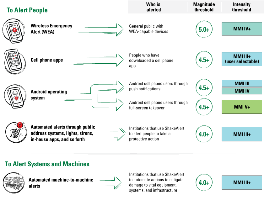
Diagram of alert delivery thresholds for the ShakeAlert System. For example, if an earthquake estimated at magnitude (M) 4.5 or greater occurs, app providers are permitted to deliver alerts to people who could feel weak shaking (at Modified Mercalli Intensity [MMI] III) or greater. Modified from U.S. Geological Survey image available at https://www.usgs.gov/media/images/alert-thresholds-shakealert.
Human Interface with Earthquake Early Warning
A strong factor in the adoption and ultimate success of the ShakeAlert EEW System is effective communication, education, outreach, and technical engagement. The USGS’s 2018 “Revised Technical Implementation Plan for the ShakeAlert System—An Earthquake Early Warning System for the West Coast of the United States” (herein referred to as the “2018 Technical Implementation Plan”; Given and others, 2018) notes that “EEW alerts are useless if people do not know how to respond to them (p. 2),” and “Extensive communication, education, and outreach (CEO) for both public and institutional users is needed for ShakeAlert to have maximum beneficial impact (p. 26).” Human interface refers to any interaction that a person has with ShakeAlert-powered products and (or) services. The interface can be direct, such as an alert delivered to a cell phone, or indirect, such as slowing a train due to a ShakeAlert-powered automated action, or a combination of both (Given and others, 2018). Accordingly, use of the ShakeAlert trademark must adhere to the ShakeAlert trademark guidelines, which are available at https://www.ShakeAlert.org.
Because ShakeAlert communication, education, outreach, and technical engagement (CEO&TE) is a collaborative effort, like the ShakeAlert System itself, the purpose of this strategic vision is to align the USGS, its principal partners, implementation partners, and other key stakeholders around the design and overarching framework for ShakeAlert CEO&TE (refer to “Governance Approach” section of this report for a detailed description of roles and responsibilities). This strategic vision was developed with substantial stakeholder input and is grounded in best practices for Federal agencies and partnership-based programs (refer to U.S. Government Accountability Office [GAO], 2012). ShakeAlert CEO&TE envisions a future where EEW is a widely integrated component of preparedness and mitigation culture in the United States. This strategic vision provides a framework to realize “earthquake early warning for all” through continued and thoughtful stakeholder engagement; a basic management, coordination, and evaluation structure; and the implementation of CEO&TE strategies founded on social science and evidence-based approaches.
Strategic Vision Overview
This strategic vision is the next step in the evolution of ShakeAlert CEO&TE and builds on the 2018 Technical Implementation Plan (Given and others, 2018). This document informs how the CEO&TE Community should operate and work together. It delineates a strategic framework that ideally can set the path for a long-term, sustainable approach to CEO&TE.
The audiences for this strategic vision include
-
• The CEO&TE Community;
-
• ShakeAlert technical partners and end users (current and potential);
-
• USGS personnel and management (Earthquake Hazards Program and other planning programs);
-
• Other agencies or organizations (for example, Federal Emergency Management Agency [FEMA], National Institute of Standards and Technology [NIST], National Science Foundation [NSF], National Oceanic and Atmospheric Administration [NOAA], Washington Emergency Management Division [WA EMD], California Governor’s Office of Emergency Services [Cal OES], Oregon Department of Emergency Management [OR OEM]); and
-
• Legislative entities and their branches (U.S. Government Accountability Office [GAO] and the Congressional Research Service [CRS]).
This strategic vision provides a
-
• Strategic framework that delineates the CEO&TE vision, mission, focus areas, priorities, target sectors, and operating principles;
-
• Governance approach that illustrates the organizational arrangement, delineates roles and responsibilities, defines decision-making parameters, and outlines an implementation approach;
-
• Structure for working groups to use in aligning their strategic and annual plans; and
-
• Performance measurement framework.
This strategic vision is not intended to
Authorities
The USGS was established by the Organic Act of March 3, 1879 (20 Stat. 394, 43 U.S.C. 31 et seq.). The Earthquake Hazards Reduction Act of Oct. 7, 1977 (P.L. 95–124 and subsequent reauthorizations) authorizes the USGS as the Federal agency responsible for providing earthquake notifications. The USGS is tasked with developing an EEW system in the United States by the Earthquake Hazards Reduction Act of 1977 (42 U.S.C. 7701 et seq.), as amended through P.L. 115–307. The most recent National Earthquake Hazards Reduction Program (NEHRP) authorization (P.L. 108–360) notes the loss-reduction value of early warning systems (sec. 7701), and specifically calls for disseminating warnings of earthquakes (sec. 7702) and authorizes the USGS to establish and operate the ANSS “…in order to enhance earthquake research and warning capabilities” (sec. 7707) (Given and others, 2018). FEMA has granted the USGS the authority to alert the public through its Integrated Public Alert and Warning System (IPAWS) (Given and others, 2018). The USGS authority for engaging in technology transfer is under the provisions of the Stevenson-Wydler Technology Innovation Act of 1980 (15 U.S.C. 3710a), as amended.
USGS’s State partners operate under their own unique authorities; of the three State partners, only California provided authorities. The California Emergency Services Act (ESA) directs Cal OES, in collaboration with the California Institute of Technology (Caltech), California Geological Survey (CGS), University of California (UC) at Berkeley, USGS, Alfred E. Alquist Seismic Safety Commission, and other stakeholders to develop a comprehensive, statewide EEW system in California through a public-private partnership (California Gov. Code sec. 8587.8). Additionally, the ESA provides that the California Earthquake Early Warning Program and California Earthquake Early Warning Advisory Board are within Cal OES (Gov. Code sec. 8587.11), and Cal OES is responsible for submitting an annual business plan in consultation with the advisory board (Gov. Code sec. 8587.12).
Current Environment and Evolution
Earthquakes are a national hazard, with more than 143 million people exposed to potentially damaging shaking in the United States (Jaiswal and others, 2015). Most of our Nation’s earthquake risk is concentrated in the highly populated areas on the active plate tectonic boundaries of the West Coast of the conterminous United States. FEMA has estimated that annual earthquake loss to the national building stock is $14.7 billion per year (Jaiswal and others, 2023). Most of the average annual loss of 65 percent ($9.6 billion per year) is concentrated in the State of California. Overall, the West Coast (California, Oregon, and Washington) accounts for 78 percent of the total average annual loss in the United States. The high concentration of loss in California is consistent with the State’s high seismic hazard and large structural exposure. The remaining 22 percent ($3.1 billion per year) of annual loss is distributed throughout the rest of the United States (including Alaska, Hawaiʻi, Puerto Rico, and the U.S. Virgin Islands) (Jaiswal and others, 2023). This estimate is only for structure-related losses and does not include other loss components, such as utility and transportation, business interruptions, and that associated with deaths and injuries.
Evolution
From its inception, ShakeAlert EEW has been a partnership between the Federal Government and the States served by the ShakeAlert System. State agencies in California, Oregon, and Washington have contributed resources to the technical buildout of the ShakeAlert system and the development of public engagement efforts. The first phase of ShakeAlert CEO&TE began in mid-2016 with the development and buildout of a comprehensive CEO&TE effort while simultaneously preparing for the rollouts of automated systems in 2018 and the testing of ShakeAlert-powered alert delivery to cell phones in California (2019), Oregon (2021), and Washington (2021). Between these rollouts, there was large-scale testing of alert delivery via the Wireless Emergency Alert System in California (two tests in 2019) and in three counties in Washington (2021). In 2019, ShakeAlert response was put to its first major test during the Ridgecrest, Calif., earthquakes on July 4 (magnitude 6.4) and on July 5 (magnitude 7.1) (refer to https://earthquake.usgs.gov/earthquakes/eventpage/ci38457511/executive).
Looking Forward
In the coming years, the ShakeAlert system is expected to complete the buildout of the three-State seismic network, introduce new earthquake detection algorithms (ongoing), integrate new sensor technologies, and accommodate the potential expansion of the system into additional States. This current strategic vision is intended to be flexible, responsive, and enduring to support continued advancements in earthquake early warning.
ShakeAlert System Ecosystem—Background and Context
The ShakeAlert Earthquake Early Warning System
The USGS Earthquake Hazards Program (EHP), along with partner organizations described hereunder, operate an EEW system, called ShakeAlert, to reduce the impact of earthquakes on human systems in the highest risk areas of the United States. At the time of publication of this strategic vision, the ShakeAlert System operates in the three West Coast States of Washington, Oregon, and California. When referring to “system” versus “System,” lowercase “s” refers to the USGS part of the operation (sensors and processing centers), and uppercase “S” refers to the USGS part and technical partners (that is, the entire System). A lowercase “s” for the USGS component is used because the ShakeAlert system is part of the larger ANSS (figs. 2 and 3), and the designation is used to show that the ShakeAlert system is subordinate to ANSS. This distinction is a USGS management decision from October 2019 and has been in use ever since.
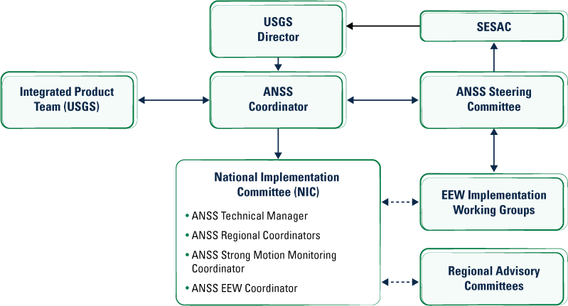
Flowchart of the high-level governance structure of the Advanced National Seismic System (ANSS), a program operated under the auspices of the U.S. Geological Survey (USGS) Earthquake Hazards Program. Solid and dashed arrows indicate formal and informal reporting relationships, respectively. EEW, earthquake early warning; SESAC, Scientific Earthquake Studies Advisory Committee. Modified from U.S. Geological Survey image available at https://www.usgs.gov/media/images/anss-committee-and-reporting-structure.
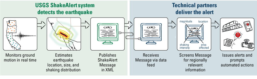
Diagram of U.S. Geological Survey (USGS)-managed ShakeAlert System roles and processes. ShakeAlert Messages published by the USGS are used by License to Operate technical partners to provide ShakeAlert-powered products and (or) services to end users. XML, Extensible Markup Language. Modified from USGS image available at https://www.shakealert.org/system-information/alert-delivery-thresholds.
The USGS EHP’s mission is to provide and apply relevant earthquake science information and knowledge to reduce deaths, injuries, and property damage from earthquakes by understanding their characteristics and effects, and by providing the information and knowledge needed to mitigate these losses (refer to https://www.usgs.gov/programs/earthquake-hazards/about#:~:text=Mission%20Statement&text=Improve%20earthquake%20hazard%20identification%20and,and%20the ir%20effects%20and%20consequences, accessed May 13, 2025). As a key tool of the USGS EHP, the ShakeAlert EEW system leverages the earthquake-monitoring capabilities of the ANSS. ShakeAlert-powered alerts are provided free of charge to the broadest public audience currently reachable via IPAWS, which is FEMA’s national system for local alerting. IPAWS provides authenticated emergency and life-saving information to the public through mobile phones using Wireless Emergency Alerts (WEA). ShakeAlert Messages (the data product of the ShakeAlert system) are issued by the USGS and provided to its technical partners, such as commercial service providers, for use in end-user-specific applications. These applications include alert delivery to individuals (for example, via a cell phone and [or] the triggering of an automated action, such as slowing a train or opening fire house doors). In alignment with USGS EHP overall, the four primary goals of ShakeAlert EEW are to save lives and minimize injuries, reduce earthquake damage to property and infrastructure systems, reduce economic impacts of earthquakes, and speed the return to normal operations and community recovery (fig. 4).
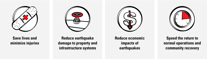
Illustrations of the four primary goals of the ShakeAlert System. Modified from U.S. Geological Survey image available at https://www.shakealert.org/wp-content/uploads/2025/03/ShakeAlert-Saves-Lives-Transparent-PNG-for-Print-and-Web-1.png.
The ShakeAlert system is also part of a larger ecosystem of ANSS earthquake information products and tools developed to rapidly disseminate information to communities that focus on critical lifelines. These include utilities, emergency response, emergency coordination, recovery, planning, and business continuity (Wald, 2020). The ANSS products are used before (to monitor), during (to alert), and after (to analyze) earthquakes. These tools are depicted in the sidebar on ANSS and figure 5.
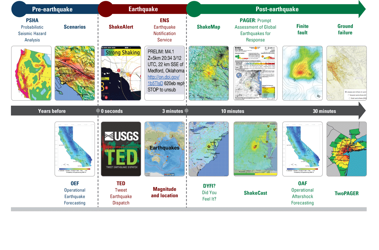
Diagram of the Advanced National Seismic System (ANSS) earthquake information products and tools used before (to monitor), during (to alert), and after (to analyze) earthquakes.
Advanced National Seismic System (ANSS) Earthquake Information Products and Tools
The ShakeAlert system is also part of a larger ecosystem of ANSS earthquake information products and tools developed to rapidly disseminate information to communities that focus on critical lifelines. These include utilities, emergency response, emergency coordination, recovery, planning, and business continuity. Modified from Wald (2020).
Latest Earthquakes Maps and information for United States and worldwide earthquakes within minutes after they occur; https://earthquake.usgs.gov/earthquakes/map.
Earthquake Notification Service Customizable earthquake information automatically sent to your wireless device or email account; https://earthquake.usgs.gov/ens.
Web Services and Feeds Real-time earthquake data in a variety of formats including RSS (Really Simple Syndication), CSV (comma-separated values), and KML (Keyhole Markup Language); https://earthquake.usgs.gov/earthquakes/feed.
Did You Feel It? Citizen-science webpage where shaking-intensity maps are created by the people who felt the earthquake; https://earthquake.usgs.gov/data/dyfi.
ShakeMap Distribution of shaking intensity from an earthquake anywhere in the world within minutes; https://earthquake.usgs.gov/data/shakemap.
ShakeCast Automated ShakeMap delivery, damage assessment, and notification for critical lifeline operators; https://www.usgs.gov/publications/earthquakes-shakecast.
PAGER/TwoPAGER Estimates of population exposure, fatalities, and economic impacts caused by shaking from significant earthquakes within minutes anywhere in the world; https://earthquake.usgs.gov/data/pager.
Ground Failure Estimates of potential landslides and liquefaction from significant earthquakes; https://earthquake.usgs.gov/data/ground-failure.
ShakeAlert Early Warning The ShakeAlert earthquake early warning system for the West Coast of the United States detects significant earthquakes quickly so that alerts can be delivered to people and automated systems; https://earthquake.usgs.gov/data/shakealert.
Aftershock Forecasting The likelihood of aftershock activity over future time intervals of a day, week, month, and year after a significant earthquake in the United States; https://earthquake.usgs.gov/data/oaf.
Earthquake Summary Posters Posters created within 24 hours after a significant earthquake with images and text about the seismic background of the area; https://earthquake.usgs.gov/education/posters.php.
Earthquake Catalog Data View historical seismicity and find past earthquakes that meet your search criteria. Various output formats and links to earthquake details are available; https://earthquake.usgs.gov/earthquakes/search.
In practice, the ShakeAlert system quickly detects and locates significant earthquakes, estimates the size and shaking, and issues ShakeAlert Messages to USGS technical partners with a License to Operate (LtO). Then, technical partners use this information to produce and deliver ShakeAlert-powered products and (or) services, such as alerts that rapidly reach people and trigger automated actions to protect vital systems and infrastructure, potentially seconds before strong shaking arrives at their location (fig. 6).
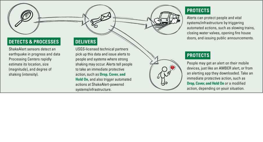
Flowchart of the ShakeAlert System illustrating the sequence to detect, deliver, and protect. The ShakeAlert system quickly detects and locates significant earthquakes, estimates the size and shaking, and issues ShakeAlert Messages to U.S. Geological Survey (USGS) technical partners who have a License to Operate (LtO). The ShakeAlert System does not predict earthquakes; rather, it uses sensors to detect an earthquake that has already started. AMBER, America's Missing: Broadcast Emergency Response. Modified from U.S. Geological Survey image available at https://www.usgs.gov/media/images/shakealert-infographic-detect-deliver-protect.
The ShakeAlert system does not predict earthquakes; rather, it uses sensors to detect an earthquake that has already started, so alerts can be delivered to people and (or) trigger automated actions to mitigate damage to vital systems. Examples of some of these potential alerts are depicted in figure 7.
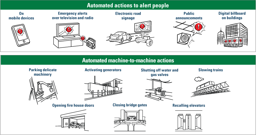
Illustration of examples of automated actions powered by the ShakeAlert system. This diagram reflects current and future implementations of ShakeAlert-powered actions, for both alerts delivered to the population and automated machine actions. Modified from U.S. Geological Survey image available at https://www.shakealert.org/wp-content/uploads/2025/03/Examples_of_Automated_Actions.png.
Strategic Framework
The strategic framework is the high-level roadmap for ShakeAlert CEO&TE efforts to ensure the ShakeAlert CEO&TE Community is working together toward a common set of goals. It includes a vision, mission, three focus areas, five priorities, target sectors, and operating principles.
CEO&TE Mission
Broaden and expand the use of earthquake early warning by people and institutions as a tool for all to live safely and thrive in earthquake country.
Focus Areas
The CEO&TE Community identified the following three focus areas to guide and align CEO&TE efforts.
-
1. Technical Engagement: Expand and broaden ShakeAlert technical engagement and implementation.—This focus is intended to expand, foster, and broaden an engagement network of technical partners and end users committed to the continued buildout and support of the earthquake early warning community. ShakeAlert Messages (published by the USGS) are used by technical partners to develop and deliver ShakeAlert-powered products and (or) services. A ShakeAlert-powered alert prompts people to take protective action, such as drop, cover, and hold on. A modified protective action can be triggered to support a broad range of populations. This is especially important in sectors most vulnerable to earthquake damage and where potential loss of life and property can be significant.
-
2. External Engagement: Engage in long-term communication, education, and outreach planning, implementation, and evaluation.—This focus creates targeted outreach and education campaigns that use an interdisciplinary process to apply social and physical science; prioritize development of customized formats to serve different audiences; incorporate lessons learned; and further align with and leverage related Federal, State, local, and non-profit earthquake preparedness programs and informational products and (or) services. The goal is to create awareness of “seconds matter” and facilitate personal protective and automated actions.
-
3. Internal Engagement: Build and sustain a robust infrastructure to optimize collaboration and project planning and facilitate timely and accurate information sharing among the community of stakeholders charged with implementing ShakeAlert CEO&TE.—This focus operates in accordance with sound governance processes and in alignment with defined roles and responsibilities. It is designed to enable decision-making protocols to ensure accountability and operational consistency, while allowing for the free exchange of information and ideas.
Priorities
ShakeAlert CEO&TE has five priorities. All CEO&TE efforts support at least one of the priorities described hereunder.
-
1. Public safety, preparedness, and resilience.—This priority includes products, programs, and (or) services that support the reduction of earthquake risk. This is done with consideration of the requirements and priorities of the emergency management community with a focus on how the ShakeAlert System can contribute to public safety, including emergency response and recovery. Emergency management agencies use other ANSS (https://www.usgs.gov/programs/earthquake-hazards/anss-advanced-national-seismic-system) information products and tools for earthquake notification (for example, the Earthquake Notification Service at https://earthquake.usgs.gov/ens), the latest Earthquake Event web pages at https://earthquake.usgs.gov/earthquakes/map, and response information (for example, ShakeMap at https://earthquake.usgs.gov/data/shakemap). Unlike the other ANSS tools that largely provide post-earthquake information, ShakeAlert EEW is an additional public safety tool that has the potential to protect people and systems before strong shaking arrives. This priority aims to integrate ShakeAlert EEW into existing earthquake preparedness efforts and other emergency management programs (for example, the Great ShakeOut at https://www.shakeout.org, 2WeeksReady at https://www.2wr.org/home, and so forth). These programs can help to position the ShakeAlert System as a tool that complements organizing disaster supplies, securing one’s space, and taking appropriate protective actions when receiving a ShakeAlert-powered alert or feeling shaking. This priority includes the exploration of future opportunities to enhance public safety using ShakeAlert and emergency management applications, like improving information sharing and coordination between earthquake early warning and tsunami warning systems.
-
2. Technical implementation and engagement.—This priority addresses the products, programs, and (or) services that support earthquake risk reduction using ShakeAlert Messages to protect people and systems. The core activity of this priority is to recruit, engage, and execute USGS license agreements with technical partners with the aim that they become licensed operators. That is, encourage technical partners to become organizations that can sell and (or) distribute ShakeAlert-powered products and (or) services. After signing a ShakeAlert Pilot License Agreement (PLA), a technical partner enters a period of research and development. To facilitate and support this process, the ShakeAlert CEO&TE Community provides technical education resources and opportunities for real-time interaction (for example, via consultations, tutorials, and so forth) that addresses technical topics that support the technical partner’s path to a becoming a License to Operate (LtO) partner.
-
3. Consistent messaging and communication.—This priority covers products, programs, and (or) services that support consistent messaging throughout the ShakeAlert System. This includes the development and evaluation of media resources, such as talking points, templated media releases, graphics, image files, frequently asked questions, web pages, and so forth. These media resources cover a broad range of topics including technical aspects of and information about the entire ShakeAlert System status and recommended protective actions when someone receives a ShakeAlert-powered alert or feels shaking. Beyond these resources, this priority addresses the ongoing coordination between the USGS and ShakeAlert partner agencies to ensure that messaging and communication is coordinated and consistent in all States where ShakeAlert has been implemented.
-
4. Integration with other Federal and State earthquake hazards products.—This priority addresses the integration of technical earthquake information products, programs, and (or) services with the ShakeAlert System. This can also include contextualizing ShakeAlert EEW in the ecosystem of earthquake information products and tools from ANSS and other sources. The ShakeAlert system produces one of many ANSS data products that may reduce earthquake risk when used in conjunction with other products, such as ShakeMap, ShakeCast, and so forth. In this context, ShakeAlert EEW has a specific role and complements the other products. A goal of this priority is to promote the integration of multiple information products and tools by ShakeAlert technical partners into their proposed ShakeAlert-powered products, services, applications, and so forth, to be implemented on the technical partner’s conversion to LtO status. This priority also includes promoting the exploration of the technical feasibility of new and (or) other information products, such as how to improve information sharing and coordination between earthquake early warning and tsunami warning systems.
-
5. Educational resources development and dissemination.—This priority includes products, programs, and (or) services that promote or deliver ShakeAlert science, technology, engineering, arts, and mathematics education for use by learners in preK–16 classrooms, museums, and other learning environments, public education campaigns, and holders of ShakeAlert license agreements. It is important that resources are developed to serve the intended audiences. A key component of this priority is to provide ShakeAlert technical partners with these resources as they develop their education and training plan during the pilot phase, and as they implement that plan after conversion to LtO status and thereafter.
Target Sectors
In advance of the USGS announcement of the 2018 implementation of automated actions (also called “ShakeAlert is Open for Business”), the CEO&TE Community identified several sectors deemed priorities for CEO&TE efforts. Additionally, as part of the ShakeAlert strategic vision development process, several additional priority sectors were identified (table 1). These sectors are delineated below and support Presidential Policy Directive 21 (PPD-21)—Critical Infrastructure Security and Resilience to integrate with other Federal and State programs where applicable; they also align to the 16 critical infrastructure sectors identified by the Cybersecurity and Infrastructure Security Agency (CISA). These sectors are defined by Presidential Policy Directive 21 (PPD–21) titled “Critical Infrastructure Security and Resilience” as
“…systems and assets, whether physical or virtual, so vital to the United States that the incapacity or destruction of such systems and assets would have a debilitating effect on security, national economic security, national public health or safety, or any combination of those matters” (Office of the Press Secretary, 2013).
The ShakeAlert CEO&TE Community acknowledges that States may use other frameworks (for example, FEMA Community Lifelines) and may prioritize different or additional sectors.
As these efforts evolve, the CEO&TE Community may want to evaluate additional critical infrastructure sectors to implement ShakeAlert automated operations, as well as identify opportunities to incorporate ShakeAlert EEW into future critical infrastructure research and development projects. Further, members of the CEO&TE Community identified educational institutions and residential housing as two additional priority sectors even though they do not correspond to a critical infrastructure sector (table 1).
Table 1.
Community education and outreach priority sectors for the ShakeAlert System.Operating Principles
Throughout the development of this strategic vision, CEO&TE Community members identified the need to understand expectations and operate in accordance with a shared set of principles. The following operating principles, expressed as statements of commitment, are derived from data collection efforts that informed this document and are central to ShakeAlert CEO&TE efforts.
-
• The nature of our work and the ShakeAlert System is inherently dynamic and requires continual reflection, assessment, and course correction. Therefore, we commit to continuous learning and improvement as the ShakeAlert System evolves.
-
• Our efforts require contributions from those who support the ShakeAlert CEO&TE mission and who also represent their individual organizations (at varying levels, from volunteer to full time). We acknowledge the multiple and complex situations faced by community members and will maintain a conducive environment for working out disagreements or different points of view.
-
• We respectfully ask how we can improve our strategy to optimize our reach while also focusing on meeting the requirements of a broad range of audiences who might use earthquake early warning systems, technologies, and messaging. We commit to presume honorable intent to ensure relevance to program goals and priorities.
-
• We recognize that differing and sometimes challenging perspectives and right-versus-right dilemmas are the foundations that guide our work. We commit in both practical action and in spirit to listen to a range of viewpoints and endeavor to meet the requirements of our broad stakeholder audiences.
-
• We commit to using a three-tiered working definition of a consensus model where:
-
• The process is explicit, rational, transparent, and fair;
-
• Participants are treated in a professional manner and their input is heard; and
-
• Participants commit to and support the outcome (and those who are ultimately accountable are authorized to make final decisions). This is also included in the decision-making framework.
-
-
• We commit to creating long-term sustainability of this program by being proactive and engaged supporters to ensure our leadership and other stakeholders understand the key benefits and value of ShakeAlert CEO&TE.
The ShakeAlert Partnership Model
The ShakeAlert System partnership between the Federal Government and the three West Coast States is currently served by the ShakeAlert system and LtO technical partners. State governments and university partners in California, Oregon, and Washington have contributed resources to the technical buildout of the ShakeAlert system and the development of a public engagement effort.
The following information briefly introduces the partners who collectively develop, operate, and maintain the entire ShakeAlert System, including those who deliver ShakeAlert-powered products and (or) services (LtO technical partners). The roles and responsibilities of all these partners as they relate to ShakeAlert CEO&TE are detailed in the “Governance Approach” section of this strategic vision.
U.S. Geological Survey
As detailed by Given and others (2018), the USGS EHP has overall responsibility for the ShakeAlert System and works closely with cooperating partners to achieve the goals of the entire ShakeAlert System (table 2). Core system management and operations, testing and certification, coordination of CEO&TE activities, and overall project management are carried out by USGS project staff, known colloquially as ShakeAlert Central. Led by a national EEW Coordinator, ShakeAlert Central is in Pasadena, California.
The USGS does not have the mission, infrastructure, or expertise to deliver mass alerts directly to the public, or to provide site-specific technology to take automated actions. Thus, the ShakeAlert strategy for alert distribution and use is to enlist technical partners with the necessary mission, technical abilities, and resources to deliver ShakeAlert-powered products and (or) services and to carry out end-user implementations. The continued expansion and sustained value of the ShakeAlert System depends on the support of public, private, philanthropic, technical, and academic partners.
University Partners and Regional Seismic and Geodetic Networks
ShakeAlert is being developed by expanding and upgrading the infrastructure of regional seismic networks that are part of the ANSS. This includes the Pacific Northwest Seismic Network (PNSN, https://www.pnsn.org), which is a partnership between the USGS, University of Washington, University of Oregon, California Integrated Seismic Network (CISN, https://www.cisn.org), and others.
In California, the ShakeAlert System is supported by the CISN, which is a partnership between the USGS, California Governor’s Office of Emergency Services (Cal OES, https://www.caloes.ca.gov), California Geological Survey (CGS, https://www.conservation.ca.gov/cgs), Southern California Seismic Network (SCSN, https://www.scsn.org), Northern California Seismic System (NCSS, https://ncedc.org/ncss), and academic institutions. University institutions involved are the California Institute of Technology (Caltech) Seismological Laboratory and the University of California (UC) Berkeley Seismological Laboratory. This enables the USGS, ANSS, and Cal OES to leverage their substantial investments in sensor networks, data telemetry systems, data processing centers, and software for earthquake monitoring activities residing in these network centers.
In addition to seismic networks, the USGS collaborates with the EarthScope Consortium (https://www.earthscope.org), which operates the National Science Foundation Geodetic Facility for the Advancement of Geoscience (GAGE), and three academic institutions to collect real-time Global Navigation Satellite System observations throughout the western United States. UC Berkeley, University of Nevada–Reno, Central Washington University (CWU), EarthScope, and USGS all provide data. EarthScope provides data-flow infrastructure and archiving, and CWU provides the real-time positions and peak ground displacement to the ShakeAlert system. The USGS-supported ShakeAlert university partners’ work is defined and supported through cooperative agreements with the USGS and is coordinated by several working groups under the guidance of the ShakeAlert Executive Committee.
The USGS also has data-sharing agreements with Mexico and Canada. Data from these countries are used by the ShakeAlert System for alert delivery in the United States only. In addition, through Canada’s use of the same ShakeAlert software, the USGS and Natural Resources Canada (NRCan) share data, thus improving both countries’ detection of and alerting for earthquakes in the border region.
State Agencies
States participate in and contribute to ShakeAlert implementation, much as they do for routine seismic monitoring and other earthquake hazard mitigation activities. Earthquake education is already in the portfolios of many State and local agencies, including Cal OES, the OR OEM, and the WA EMD. Organizations including EarthScope Consortium, Statewide California Earthquake Center (formerly Southern California Earthquake Center, https://www.scec.org), Cascadia Region Earthquake Workgroup, and Earthquake Country Alliance also have well-established communication, education, and outreach programs. As of the date of publication of this strategic vision, there has been notable progress in the integration of ShakeAlert EEW into their existing earthquake preparedness efforts.
The State of California has provided substantial funding for the ShakeAlert system and has supported earthquake monitoring since 2001. It made EEW a priority in 2016 by enacting legislation that created the California Earthquake Early Warning Program within Cal OES, as well as the California Earthquake Early Warning Advisory Board, to advise the Cal OES Director. Cal OES developed an EEW Business Plan (Newman and others, 2018) and is exploring models to fund ongoing operation of ShakeAlert, EEW education, and user engagement activities in California.
The State of Oregon appropriated funds to purchase seismic stations to enhance and contribute to ShakeAlert. The State of Washington is strongly supportive of the ShakeAlert initiative, provides some base funding of the PNSN, and houses the operation at the University of Washington in Seattle.
Technical Partners
Technical partners are integral to the success of the ShakeAlert System. By building technologies that deliver ShakeAlert-powered products and services, technical partners can help to save lives, minimize injuries, and (or) reduce earthquake damage to property and infrastructure. A technical partner is any entity that enters into a Pilot License Agreement (PLA) with the USGS with the goal of obtaining License to Operate (LtO) status. LtO partners use USGS-issued ShakeAlert Messages for ShakeAlert-powered products and (or) services. Technical partners span multiple industries and sectors and include private for-profit companies, public entities, and nonprofit entities that can demonstrate a public safety benefit by becoming part of the ShakeAlert System.
Technical Partners
Pilot partners develop and internally test innovative ways to use ShakeAlert Message data to deliver alerts that prompt people and systems to take protective actions.
License to Operate (LtO) partners have met USGS-mandated standards for speed, reliability, and technical performance, including providing appropriate education and training for their end users. LtO partners are approved to provide or sell their developed product to end users.
Other Partners
Evaluation partners are observation-only partners who are credentialed to connect to the ShakeAlert system data feed but cannot take an action or develop products based on ShakeAlert information. Evaluation partners are provided an opportunity to learn more about how the ShakeAlert System works and the products it produces, so entities can evaluate if they want to become a pilot partner or an end user.
Communication, education, and outreach (CEO) partners are not pursuing a technical implementation of ShakeAlert EEW; rather, they partner with the USGS on the development of education and (or) training resources for ShakeAlert EEW.
Communication, Education, Outreach, and Technical Engagement
To support ShakeAlert System goals, a broad array of stakeholders is engaged in CEO&TE efforts (fig. 8). Further described in the “Governance Approach” section of this document, these stakeholders represent the USGS, universities, State emergency management agencies, State geological surveys, technical partners, and those with specialized subject matter expertise. Examples of subject matter experts include social science researchers, educators, and external affairs professionals. A subset of these stakeholders convenes as the CEO&TE Community under the auspices of the USGS Earthquake Hazards Program.
Though not members of the CEO&TE Community, technical partners are indispensable to the USGS Earthquake Hazards Program’s mission and continued buildout of an EEW industry where ShakeAlert Messages are used to develop and deliver alerts. A comprehensive technical engagement program is intended to foster long-term relationships and provide resources for the successful implementation of the entire ShakeAlert System.
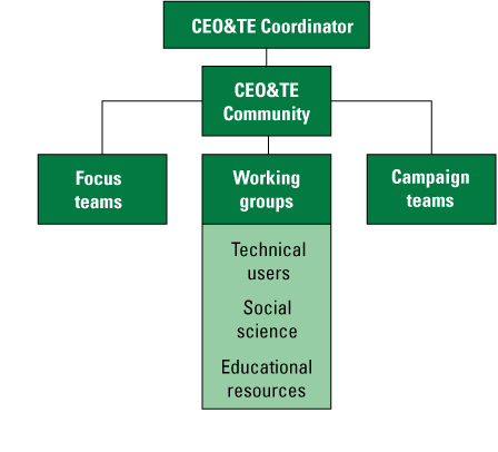
Diagram describing the U.S. Geological Survey hierarchy of ShakeAlert System communication, education, outreach, and technical engagement (CEO&TE) organizational structure.
“The USGS strategy is to coordinate, but not carry out, public education and training related to ShakeAlert, with the expectation that [CEO&TE professionals in States where the ShakeAlert System is implemented] would leverage existing earthquake education programs by integrating ShakeAlert EEW with them” (Given and others, 2018, p. 28).
As much as possible, all ShakeAlert CEO&TE products and (or) services must be informed by the research literature, disciplinary background, and by the expertise of the many practitioners in the CEO&TE Community. Ongoing evaluation and monitoring can ensure that all CEO&TE products, programs, and services are continually updated and improved to optimize public safety.
The CEO&TE Community serves to implement this strategy. If opportunities arise, pivoting on projects is supported, based on the goals and objectives set out in this strategy.
Communication, Education, Outreach and Technical Engagement Community
A subset of the ShakeAlert System convenes as the CEO&TE Community to provide feedback regarding the ShakeAlert System’s human interface (fig. 8). The CEO&TE Community coordinates development, implementation, and evaluation of CEO&TE resources that are fundamental to the successful operation of the ShakeAlert System, and which direct people and (or) systems to take a protective action if shaking is felt or if a ShakeAlert-powered alert is received. The CEO&TE Community coordinates and implements technologies that trigger automated actions to protect lives and reduce property damage. The CEO&TE Community considers lessons learned from ShakeAlert implementations, best practices from experience, results of social science research, and with consideration of end-user input.
Social Science
Social science is broadly defined as a systematic study of people, their societies, governments, and their social, cultural, communication, learning, geographical, and economic structures (Hicks, 2004). Optimizing human interaction with the ShakeAlert System that results in positive effects on public safety is a primary measure of EEW success. This optimization is delineated as a key performance indicator in the “Performance Measurement Framework” section of this strategic vision. This can be achieved through contributions and coordinated integration of research from disciplines (for example, sociology, psychology, education, and communication) and productive interaction with physical scientists who manage the technical aspects of the USGS-operated ShakeAlert system.
Social science has the potential to contribute to ShakeAlert CEO&TE efforts in at least three distinct ways. From development through its operational phase, the ShakeAlert System has relied on input from social scientists to aid in decisions, such as appropriate alert delivery thresholds, the contents of the alert messages themselves, and how to best communicate if the technical aspects of the ShakeAlert System do not operate as expected. Secondly, social science contributes to the ongoing work of the CEO&TE Community by providing a research-based foundation for the development of education and training products, programs, and services. This could include the development of ShakeAlert-style earthquake drills and exercises, integration of protective action information into technical partner education and training manuals, and (or) the development of an educational activity that teaches the difference between magnitude and intensity (which is fundamental to understanding what to expect from EEW). Finally, ShakeAlert social science research has the potential to contribute to the body of literature (for example, risk communication, science education, human behavior, and so forth) and the greater research community within and external to the USGS.
Governance Approach
There is an extensive network of stakeholders who are part of the ANSS and ShakeAlert systems. Successful implementation of EEW requires a broad community of willing and engaged participants. The following governance approach depicts the organizational arrangement and delineates roles and responsibilities of entities that have been and will continue to be foundational to and responsible for the long-term success and sustainability of ShakeAlert CEO&TE efforts. This current approach addresses gaps identified in the GAO–21–129 report (GAO, 2021) by further defining roles and responsibilities and related program management considerations. The governance approach also outlines parameters intended to create understanding, consistency, and transparency related to decision-making.
Organizational Arrangement
The ShakeAlert CEO&TE organizational arrangement is described in table 2.
Table 2.
Roles and organizational responsibilities for communication, education, outreach, and technical engagement (CEO&TE) for the ShakeAlert System.[CEO, communication, education, and outreach; USGS, U.S. Geological Survey]
Committees, Working Groups, Special Projects Teams, and Standing Forums
ShakeAlert CEO&TE work, including entities noted above as well as focus teams and other CEO&TE staff (for example, contractors, intergovernmental personnel act [IPA] staff, and USGS staff), is intended to support the implementation of the five CEO&TE priorities outlined in the “Priorities” section of the “Strategic Framework” section. All members of the CEO&TE Community bring their skills, knowledge, and expertise, both individually and as part of the CEO&TE organizational arrangement (table 2). To effectively carry out the five priorities, there is need for collaboration across the CEO&TE Community and with external partners. Table 3 describes the mechanisms used to effectively enable collaboration across the entire CEO&TE effort. Roles and responsibilities, as well as membership of the committees, working groups, special projects teams, and standing forums are detailed hereunder (tables 4–9). Names of members and the organizations they represent are managed by the CEO&TE Community Coordinator (fig. 8).
Table 3.
U.S. Geological Survey (USGS) and Communication, Education, Outreach, and Technical Engagement (CEO&TE) Community collaboration groups in the ShakeAlert System.[CEO, communication, education, and outreach; ELA, Evaluation License Agreement; LtO, License to Operate; PLA, Pilot License Agreement]
Table 4.
Lead agency, its offices, and their responsibilities in the ShakeAlert System.[CEO, communication, education, and outreach; CEO&TE, communication, education, outreach and technical engagement; GPS, Global Positioning System; USGS, U.S. Geological Survey]
Table 5.
Principal partners and their responsibilities in the ShakeAlert System.[CEO&TE, communication, education, outreach, and technical engagement; CoreCom, Core Committee]
Table 6.
Implementation partners and their responsibilities in the ShakeAlert System.[FEMA, Federal Emergency Management Agency; NIST, National Institute of Standards and Technology; NOAA, National Oceanic and Atmospheric Administration; NSF, National Science Foundation; USGS, U.S. Geological Survey]
Table 7.
Committees and their responsibilities in the ShakeAlert System.[ANSS, Advanced National Seismic System; CEO&TE, communication, education, outreach and technical engagement; EEW, earthquake early warning; USGS, U.S. Geological Survey]
Table 8.
Working groups and their responsibilities in the ShakeAlert System.[CEO&TE, communication, education, outreach and technical engagement; EEW, earthquake early warning; NRCan, Natural Resources Canada; USGS, U.S. Geological Survey]
Table 9.
Special projects teams and their responsibilities in the ShakeAlert System.[CEO&TE, communication, education, outreach, and technical engagement; CoreCom, Core Committee; OBFA, Office of Budget, Finance and Analysis; OCAP, Office of Communications and Publishing; USGS, U.S. Geological Survey]
Decision-Making in CEO&TE
The success of ShakeAlert CEO&TE is predicated on robust collaboration, communication, and coordination. In keeping with the ShakeAlert project operating principles, charters, and formal agreements, the CEO&TE Community serves as a group of subject matter experts who work together to explore opportunities, solve problems, and implement solutions, representing the collective interests of ShakeAlert CEO&TE and benefitting from the extensive experience and deep subject matter expertise of its members. The CEO&TE Community is the forum through which States and other members of the CEO&TE Community provide input. This input is ultimately curated and used by USGS and the States in decisions about how to best support and advance progress within the focus areas and priorities as defined in this strategic vision.
The CEO&TE Community uses a consensus-based approach, also delineated as an operating principle, for decision-making. There is no expectation that principal partners and others follow this exact process for their allocated resources or funding, though coordination and consensus-building are still desired. The CEO&TE Community observes the following guidelines in making its decisions:
-
• The process to make decisions is explicit, rational, transparent, and fair.
-
• CEO&TE Community members are afforded the opportunity to help shape priorities; however, the CEO&TE Community is not an advisory nor guidance body.
-
• Respect multiple and potentially differing member perspectives and limitations while keeping the focus on the ShakeAlert CEO&TE vision, mission, focus areas, and priorities (as defined in this strategic vision).
Curated input and feedback from the CEO&TE Community are also used to draft recommendations. These draft recommendations are circulated within State agencies according to their established protocols and, ultimately, are proposed to the Earthquake Early Warning External Working Group, ANSS Steering Committee, Earthquake Hazards Program Advisory Committee, and Scientific Earthquake Studies Advisory Committee for consideration. Decisions and formative input are communicated to members of the CEO&TE Community and, as appropriate, are incorporated to ensure alignment with the CEO&TE strategic framework.
Decision-Making Parameters
All proposed ShakeAlert CEO&TE products, services, and (or) projects must align with one or more of the identified five priorities, advance progress in at least one of the three focus areas, and align with the CEO&TE mission and vision. Additionally, the USGS considers the following part of its decision-making framework:
-
• Ability to scale and broadly affect the following:
-
• States where ShakeAlert EEW is operating and could be leveraged as part of future expansion to other States.
-
• Groups with wider reach and more leverage (for example, school districts versus individual schools, industry groups, such as the National Association of Home Builders, and large technology companies, such as Google).
-
• Policy and (or) institute mandates through legislative and related avenues.
-
• Dissemination, application, and integration of previously created resources (versus creating new material).
-
• New or existing grant programs that can provide the financial resources for ShakeAlert implementation.
-
• Align with and support the ShakeAlert System, the USGS Earthquake Hazards Program.
-
-
• Stay informed by social science.
-
• Demonstrate integration of findings from CEO&TE Community committees and working groups (that is, avoid working in isolation).
Implementation Approach
As depicted in the organizational arrangement, working groups (fig. 8) are instrumental for advancing the mission and supporting the priorities and focus areas delineated in the strategic framework. Each working group has its own strategic vision that aligns with this overarching strategic vision, and each also creates an annual work plan that outlines specific projects and work efforts that align with the strategic framework defined herein. Commonly, those projects are implemented by and through principal and implementation partners with support from the lead agency. Also (as described in the “Organizational Arrangement” section of this document), special projects teams may be convened to address emerging requirements and (or) capitalize on emerging opportunities.
Regardless of who is carrying out ShakeAlert CEO&TE work, in addition to using the decision-making parameters outlined above, answering the following inquiries can help ensure efforts optimize resources, support ShakeAlert goals, and align with ShakeAlert CEO&TE priorities and focus areas. Ultimately, the goal is to deliver implementation-driven results.
-
• How will <insert: product/service/technology/process> help to support ShakeAlert goals to save lives and minimize property damage?
-
• How will <insert: product/service/technology/process> support <insert: state/county/entity> to successfully implement ShakeAlert CEO&TE?
-
• Who is the intended audience for <insert: product/service/technology/process> and what action would <insert: the intended audience> take?
-
• How will <insert: product/service/technology/process> further the CEO&TE mission to “broaden and expand the use of earthquake early warning by people and institutions as a tool for all to live safely and thrive in earthquake country?”
-
• How will <insert: product/service/technology/process> support the ShakeAlert CEO&TE focus areas and priorities?
Throughout the development of this strategic vision, members of the CEO&TE Community have provided substantial input regarding potential CEO&TE activities. These project ideas could be considered to advance CEO&TE progress and might be used by working groups in the development of their annual work plans. These project ideas are available to all members of the CEO&TE Community on the ShakeAlert.org members-only portal.
Performance Measurement Framework
The purpose of the ShakeAlert CEO&TE performance measurement framework (PMF) is to ensure efforts are aligned with and support the strategic framework (vision, mission, focus areas, and priorities). The PMF serves as a management and accountability tool as well as a resource to help the members of the CEO&TE Community determine when and where changes are required. As with this strategic vision itself, the PMF is intended to be flexible and adaptable to align with new or changing priorities, such as any identified in future years by the CEO&TE Community, working groups, and (or) the USGS.
The PMF is based on a key performance indicators (KPIs) approach. KPIs are the elements of the strategic vision that express what is to be achieved and when; they are quantifiable, outcome-based evaluations used to determine if efforts are on track. The CEO&TE Community identified eight KPIs to manage and track the progress of this strategic vision (table 10). This section is based on a best-practices construct and is populated with input provided by members of the ShakeAlert community. It is intended to focus on measures and outcomes over metrics. This will require the CEO&TE Community to collaboratively develop targets, data sources, and reporting frequencies. Table 10 defines eight key performance indicators for the CEO&TE Community.
Table 10.
Key performance indicators (KPIs) and measures for the ShakeAlert communication, education, outreach and technical engagement (CEO&TE) strategic vision.[CEO, communication, education, and outreach; CoreCom, Core Committee; EEW, earthquake early warning; USGS, U.S. Geological Survey]
References Cited
Given, D.D., Allen, R.M., Baltay, A.S., Bodin, P., Cochran, E.S., Creager, K., de Groot, R.M., Gee, L.S., Hauksson, E., Heaton, T.H., Hellweg, M., Murray, J.R., Thomas, V.I., Toomey, D., and Yelin, T.S., 2018, Revised technical implementation plan for the ShakeAlert system—An earthquake early warning system for the West Coast of the United States: U.S. Geological Survey Open-File Report 2018–1155, 42 p., https://doi.org/10.3133/ofr20181155. [Supersedes USGS Open-File Report 2014–1097.]
Jaiswal, K.S., Rozelle, J., Tong, M., Sheehan, A., McNabb, S., Kelly, M., Zuzak, C., Bausch, D., and Sims, J., 2023, Hazus estimated annualized earthquake losses for the United States: Federal Emergency Management Agency FEMA P–366, 98 p., accessed March 19, 2025, at https://www.fema.gov/sites/default/files/documents/fema_p-366-hazus-estimated-annualized-earthquake-losses-united-states.pdf.
Jaiswal, K.S., Petersen, M.D., Rukstales, K.S., and Leith, W.S., 2015, Earthquake shaking hazard estimates and exposure changes in the conterminous United States: Earthquake Spectra, v. 31, p. S201–S220, https://doi.org/10.1193/111814EQS195M.
Newman, M., Connolly, K., and Gage, T., 2018, Implementing earthquake early warning in California—A business plan for the California earthquake early warning system: California Governor’s Office of Emergency Services, prepared by Blue Sky Consulting Group, Oakland, Calif., 69 p., accessed March 19, 2025, at https://www.caloes.ca.gov/wp-content/uploads/Earthquake-Tsunami-Volcano/Documents/CEEWP-Business-Plan-Final.pdf.
Office of the Press Secretary, 2013, Critical infrastructure security and resilience: Presidential Policy Directive PPD–21, February 12, 12 p., accessed May 13, 2025, at https://www.cisa.gov/sites/default/files/2023-01/ppd-21-critical-infrastructure-and-resilience-508_0.pdf.
U.S. Government Accountability Office [GAO], 2012, Managing for results—Key considerations for implementing interagency collaborative mechanisms: U.S. Government Accountability Office report GAO–12–1022, 41, p., accessed March 19, 2025, at https://www.gao.gov/products/gao-12-1022.
U.S. Government Accountability Office [GAO], 2021, Earthquakes—Progress made to implement early warning system, but actions needed to improve program management: U.S. Government Accountability Office web page, GAO–21–129, accessed 03 19, 2025 at https://www.gao.gov/products/gao-21-129.
Wald, L.A., 2020, Earthquake information products and tools from the Advanced National Seismic System (ANSS): U.S. Geological Survey Fact Sheet 2020–3042, 2 p., https://doi.org/10.3133/fs20203042.
Glossary
The U.S. Geological Survey (USGS) recognizes that from time to time, websites may change resource locations and as such, those identified herein may move or become temporarily unlinked.
- ANSS
The Advanced National Seismic System (ANSS) includes a national Backbone network, the National Earthquake Information Center (NEIC), the National Strong Motion Project, and 15 regional seismic networks operated by the USGS and its partners. (Refer to https://www.usgs.gov/programs/earthquake-hazards/anss-advanced-national-seismic-system, accessed April 20, 2024.)
- CEO&TE Community
Communication, education, outreach, and technical engagement (CEO&TE) group under the auspices of the USGS Earthquake Hazards Program to provide feedback regarding the ShakeAlert System’s human interface.
- CEO&TE Community campaign teams
Campaign teams are special project teams that are involved in efforts (or projects) that require short-term or ad hoc cross-coalition collaboration and participation across the Communication, Education, Outreach and Technical Engagement (CEO&TE) Community, such as a system-wide rollout, major milestone, an earthquake of great significance, and so forth. These endeavors could require participation from all people involved or have more of a regional focus, depending on the nature of the campaign.
- CEO&TE Community focus and (or) task teams
Communication, Education, Outreach and Technical Engagement (CEO&TE) Community focus teams convene to complete time-bound (some lasting months) and narrow-scope projects that address specific ShakeAlert CEO&TE priorities. Focus teams include members of the CEO&TE Community (and in some cases external experts) who have expertise related to and (or) interest in contributing to a special project.
- CEO&TE TUWG
Communication, Education, Outreach and Technical Engagement (CEO&TE) Community Technical Users Working Group. The TUWG mission is to develop and maintain ShakeAlert technical partners and partnerships, resulting in the development of products and programs that contribute to the successful private-public implementation of the ShakeAlert System. TUWG is led by a team of Technical Engagement Regional Coordinators (TERCs).
- CISN
California Integrated Seismic Network. Network members are the California Institute of Technology [Caltech], University of California Berkeley, California Geological Survey, USGS, and California Governor’s Office of Emergency Services. (Refer to https://www.cisn.org.)
- Community forum
A community forum is a collection of individuals and organizations reflecting the broadest group within the ShakeAlert community and includes but is not limited to the Core Committee (CoreCom), all ShakeAlert licensees (Evaluation License Agreement [ELA], Pilot License Agreement [PLA], communication, education, and outreach [CEO], and License to Operate [LtO], USGS staff, detailees, contractors, and so forth), implementation partners, and others.
- Cooperative agreements
Cooperative agreements are legal instruments where the principal purpose is to transfer funds or property to provide support or stimulation authorized by statute, and where substantial involvement is expected between the USGS and the recipient when performing the activity. There is a participatory relationship, thus establishing the USGS as a “partner” with shared performance responsibility (https://www.usgs.gov/office-of-acquisition-and-grants/guide-submitting-unsolicited-proposals, accessed March 19, 2025).
- CoreCom
The Core Committee (CoreCom) is the leadership team of the Communication, Education, Outreach and Technical Engagement (CEO&TE) Community.
- Earthquake notification
If their agreement with the USGS allows for it, ShakeAlert License to Operate (LtO) partners are permitted to use the data in ShakeAlert Messages to deliver earthquake notifications to end users. Notifications are delivered after an earthquake to provide situational awareness or perform another non-alerting function. Although the primary use of ShakeAlert data is for the development and delivery of alerts that prompt an immediate action, there may be yet unrealized novel applications for the data in ShakeAlert Messages.
- Earthquake Notification Service
Earthquake Notification Service is a free service that can send automated notification emails when earthquakes happen in a selected area. (Refer to https://earthquake.usgs.gov/ens.)
- Earthquake Country Alliance
Earthquake Country Alliance is a public-private-grassroots partnership of people and organizations that work together to improve earthquake and tsunami preparedness, mitigation, and resiliency. (Refer to https://www.earthquakecountry.org.)
- EarthScope Consortium
The EarthScope Consortium (https://www.earthscope.org) supports global geophysical research and education to build earthquake-resilient communities. EarthScope continues the operation of National Science Foundation’s (NSF’s) Geodetic Facility for the Advancement of Geoscience (GAGE) and Seismological Facility for the Advancement of Geoscience (SAGE), previously operated by the University NAVSTAR Consortium (UNAVCO) and Incorporated Research Institutions for Seismology (IRIS). In 2023, the EarthScope Consortium was formed from the merger of IRIS and UNAVCO.
- EEW
Earthquake early warning is the general principle of public safety technologies that rapidly detect an earthquake at Earth’s surface and process that data with the goal to deliver alerts to people and to systems prompting an immediate action before damaging shaking arrives at their locations. (Refer to https://www.usgs.gov/programs/earthquake-hazards/science/earthquake-early-warning-overview).
- ELA
Evaluation License Agreement (ELA) partners are observation-only partners who are allowed to connect to the ShakeAlert System data feed but cannot take action or develop products based on this ShakeAlert information. An evaluation partnership provides an opportunity to learn more about how the ShakeAlert System works and its products, so entities can evaluate if they want to become a pilot partner or an end user.
- End user
End users receive ShakeAlert-powered products and (or) services from License to Operate (LtO) partners. End users include people who receive these products and (or) services directly (for example, to their cell phones), as well as organizations that work with an LtO partner to implement automated machine-to-machine actions (for example, slowing or stopping trains, opening fire house doors, and so forth).
- ERWG
Communication, Education, Outreach and Technical Engagement (CEO&TE) Community Educational Resources Working Group. The ERWG mission is to develop educational resources to increase awareness of ShakeAlert earthquake early warning, share resources with communities through a collaborative approach, and assess the effectiveness of the resources through educational research best practices.
- Great ShakeOut
Great ShakeOut earthquake drills are an annual opportunity for people in homes, schools, and organizations to practice what to do during earthquakes and to improve preparedness. These events are made possible through a collaboration between several agencies, including the USGS. (Refer to https://www.ShakeOut.org.)
- Human interface
A human interface is any mode of interaction that a person has with ShakeAlert-powered products and (or) services, based on the use of ShakeAlert Messages by USGS-licensed ShakeAlert technical partners. The interface can be direct, such as an alert delivered to a cell phone; indirect, such as a ShakeAlert-powered automated protective action (that is, machine-to-machine); or a combination of both.
- KPI
Key performance indicator. KPIs are the elements of the strategic vision that express what is to be achieved and when; the focus areas and priorities KPIs are the quantifiable, outcome-based evaluations used to determine if efforts are on track.
- Licensee
A licensee is a holder of a USGS ShakeAlert license agreement, such as an Evaluation License Agreement (ELA), Pilot License Agreement (PLA), License to Operate (LtO), and (or) Communication, Education, and Outreach (CEO) License Agreement.
- LtO partner
On conversion from a pilot partner to a License to Operate (LtO) technical partner, the USGS grants a ShakeAlert licensee the right to distribute ShakeAlert-powered products and (or) services to the public and (or) to automated systems, subject to limitations set forth by the USGS for the technology and field of use identified in the license agreement between the USGS and the LtO technical partner.
- Pilot partner
A pilot partner is a technical partner that holds a current Pilot License Agreement (PLA) with the USGS. Technical partners build systems to deliver ShakeAlert-powered products and (or) services.
- PLA
A Pilot License Agreement (PLA) with the USGS allows technical partners to research, develop, and internally test innovative ways to use ShakeAlert Messages to deliver ShakeAlert-powered products and services to the public and (or) to automated systems, subject to limitations set forth by the USGS for the technology and field of use identified in the license agreement between the USGS and the technical partner.
- ShakeAlert Central
The team of USGS project staff with dedicated responsibility for the ShakeAlert system. ShakeAlert central staff act as chairs of most of the standing working groups. This team coordinates with the Executive Committee and the various working groups to ensure the successful operations and ongoing development of the ShakeAlert system. Tasks include monitoring whole-system performance, ensuring that performance goals are met, post-event response, and guiding technical and scientific development of the system.
- ShakeAlert Project
The official USGS name for the ShakeAlert earthquake early warning system (https://www.ShakeAlert.org).
- Social science
Social science is broadly defined as a systematic study of people, their society, and their governmental, social, cultural, communication, geographical, and economic structures.
- SSWG
CEO&TE Community Social Science Working Group. SSWG stakeholders include representatives from across the ShakeAlert CEO&TE Community. The membership focus is for researchers who are actively working on ShakeAlert or earthquake early warning (EEW) social science research, as well as USGS designees.
- Technical engagement
An interaction with current or prospective ShakeAlert technical partners.
- Technical partner
A technical partner is a ShakeAlert System licensee who holds a current Pilot License Agreement (PLA) or License to Operate (LtO) agreement with the USGS. Technical partners build systems to deliver ShakeAlert-powered products and (or) services.
- TED
Tweet Earthquake Dispatch (on X [formerly Twitter]), Facebook, and so forth). Issued under the auspices of the USGS Office of Communications and Publishing who coordinate USGS social media accounts.
Abbreviations
AMBER
America’s Missing: Broadcast Emergency Response
ANSS
Advanced National Seismic System
Cal OES
California Governor’s Office of Emergency Services
Caltech
California Institute of Technology
CEO
communication, education, and outreach
CEO&TE
communication, education, outreach, and technical engagement
CISA
Cybersecurity and Infrastructure Agency (Department of Homeland Security)
CISN
California Integrated Seismic Network
CGS
California Geological Survey
CRS
Congressional Research Service
CWU
Central Washington University
EEW
earthquake early warning
EHP
Earthquake Hazards Program (USGS)
ELA
Evaluation License Agreement
ESA
Emergency Services Act (California)
FEMA
Federal Emergency Management Agency
GAO
U.S. Government Accountability Office
IPAWS
Integrated Public Alert and Warning System (FEMA)
KPI
key performance indicator
LtO
License to Operate
NIST
National Institute of Standards and Technology
NOAA
National Oceanic and Atmospheric Administration
NRCan
Natural Resources Canada
NSF
National Science Foundation
OMSI
Oregon Museum of Science and Industry
OR OEM
Oregon Department of Emergency Management
PLA
Pilot License Agreement
PMF
performance measurement framework
PNSN
Pacific Northwest Seismic Network
WA EMD
Washington Emergency Management Division
WEA
Wireless Emergency Alerts (FEMA)
UC
University of California
USGS
U.S. Geological Survey
UW
University of Washington
Moffett Field Publishing Service Center, California
Manuscript approved June 23, 2025
Edited by Lisa J. Binder and Monica Erdman
Design and layout by Cory Hurd
Disclaimers
Any use of trade, firm, or product names is for descriptive purposes only and does not imply endorsement by the U.S. Government.
Although this information product, for the most part, is in the public domain, it also may contain copyrighted materials as noted in the text. Permission to reproduce copyrighted items must be secured from the copyright owner.
Suggested Citation
de Groot, R.M., McBride, S.K., Vinci, M.J., Lotto, G.C., Anderson, M.L., Sumy, D.F., and Terbush, B., 2025, ShakeAlert—Communication, education, outreach, and technical engagement strategic vision: U.S. Geological Survey Circular 1561, 32 p., https://doi.org/10.3133/cir1561.
ISSN: 2330-5703 (online)
| Publication type | Report |
|---|---|
| Publication Subtype | USGS Numbered Series |
| Title | ShakeAlert®—Communication, education, outreach and technical engagement strategic vision |
| Series title | Circular |
| Series number | 1561 |
| DOI | 10.3133/cir1561 |
| Publication Date | September 23, 2025 |
| Year Published | 2025 |
| Language | English |
| Publisher | U.S. Geological Survey |
| Publisher location | Reston, VA |
| Contributing office(s) | Earthquake Science Center |
| Description | vi, 32 p. |
| Online Only (Y/N) | Y |