

Artificial Intelligence Strategy for the U.S. Geological Survey
Links
- Document: Report (2.26 MB pdf) , HTML , XML
- Download citation as: RIS | Dublin Core
Abstract
Artificial intelligence (AI) can offer opportunities to enhance the science, science delivery, and business operations of the U.S. Geological Survey (USGS). Although USGS staff have proactively adopted AI into our workflows for many years, a comprehensive USGS strategy for AI has not previously been developed. The strategy described here is motivated by the acceleration of AI technological development, the benefits of increased AI adoption to USGS mission delivery as anticipated by USGS staff, rising public concern about the implications and trustworthiness of AI, and emerging Federal directives and guidance about AI. The USGS vision is to continue integrating AI to deliver valuable science for the public good while maintaining high ethical standards, scientific quality and integrity, and compliance with Federal and U.S. Department of the Interior requirements. To realize this vision, the USGS can take steps to (1) develop a strong AI workforce, (2) adapt our organizational approaches to include AI governance and communication, (3) ensure responsible and trustworthy use of AI, (4) modernize our computing and data infrastructure to support AI, and (5) accelerate AI adoption and innovation in the Bureau.
Introduction
The strategic adoption and development of artificial intelligence (AI) technology has the potential to transform and accelerate the science and effectiveness of the U.S. Geological Survey (USGS). AI is broadly defined as “a machine-based system that can, for a given set of human-defined objectives, make predictions, recommendations, or decisions” (from 15 U.S.C. 9401(3), in U.S. Congress, 2020). USGS researchers have long been adopters of AI starting in the late 1990s and early 2000s (Lemeshewsky, 1997; Singer and Kouda, 1997; Guinand and others, 2002; Waddle and others, 2009; Huang and others, 2010) to help scientific understanding of Earth system processes and better equip the USGS to serve the Nation. Additionally, emerging generative AI capabilities have begun shifting the paradigm of work, automating or accelerating previously time-consuming tasks, such that USGS staff can increasingly focus on the elements of their work that require human judgment and ingenuity.
To date (2025), many USGS successes with AI have focused on the use of AI to analyze Earth observation data in support of our 21st-Century Science Strategy (U.S. Geological Survey, 2021). USGS researchers have used AI to assess human-environment relationships between traffic and caribou movement (Severson and others, 2023), extreme wetland methane emissions (Feron and others, 2023), prescribed burns and grassland fire fuels (Wells and others, 2021), and much more. The USGS uses AI to process large volumes of imagery and sensor data to extract terrain features from topographic data (Usery and others, 2021), characterize coastal landforms (Buscombe and others, 2023), track condor behaviors (Sur and others, 2023), and monitor for earthquakes (Yeck and others, 2021). The USGS also uses AI to inform environmental resource decision making, such as for forecasting river temperatures downstream of reservoirs (Zwart and others, 2023), identifying climate-resistant vernal pools (Cartwright and others, 2022), and predicting the locations of mineral deposits (Lawley and others, 2022). The USGS not only uses AI for Earth science but also leads cutting-edge research in the field of geospatial AI (GeoAI), combining geospatial science with AI to leverage insights from spatiotemporal data (Li and others, 2024). The USGS is ready to build on these and many other AI research successes as new AI methods and opportunities emerge.
The USGS can build on a foundation of organizational practices that ensure the quality and richness of its information products. For example, sound data management and high-quality data are the bedrock of successful AI applications, and the USGS has a strong data-centric culture and vision as outlined in the USGS Data Strategy (Hutchison and others, 2024). Additionally, overall science quality at the USGS is assured by the Office of Science Quality and Integrity through its Fundamental Science Practices policies (Fundamental Science Practices Advisory Council, 2023), which will help guide USGS research through the responsible adoption of new AI technologies.
As AI tools become increasingly powerful and versatile, USGS AI applications are also diversifying. AI is already enabling efficiency gains, such as in the extraction of information from old geological maps (Lederer and others, 2022). The advent of generative AI models trained on massive datasets promises productivity gains for writing, reading, data visualization, and coding, while simultaneously raising challenges in learning to apply and govern such uses effectively (Dell’Acqua and others, 2023; National Institute of Standards and Technology [NIST], 2023). Generative AI approaches also offer new opportunities such as the potential development of Earth system (Wang and others, 2024) and geospatial (IBM and NASA, 2023) foundation models that can ingest and predict varied information, adding efficiencies and robustness to the USGS’s science modeling. As the field of AI continues to progress, a potential challenge will be to provide user support, advanced data and computing infrastructure, incentives, and guard rails to ensure that the USGS can adopt emerging AI tools while maintaining the quality and integrity of our science products.
Deeper integration of AI into USGS science and business practices is supported by Federal policies and guidelines. Executive Order 14179, “Removing Barriers to American Leadership in Artificial Intelligence,” motivates U.S. global leadership in AI “to promote human flourishing, economic competitiveness, and national security” (White House, 2025a), positioning the USGS to take leadership in AI for Earth and geospatial sciences to better provide unbiased scientific information to our stakeholders, decision makers, and the American public. Memorandum M-25-21, “Accelerating Federal Use of AI through Innovation, Governance, and Public Trust” (Office of Management and Budget [OMB], 2025b), encourages agencies to accelerate responsible AI adoption, increase transparency, and govern for safe innovation while protecting the privacy, civil liberties, and civil rights of Americans through risk management practices. The USGS strategy recommendations in this report can help our organization align with Federal and Department of the Interior AI objectives by building on existing organizational structures, policies, and practices.
In the following sections we describe five goals and corresponding objectives to support the development of efficient and robust approaches to incorporate AI into USGS research and operations. The five goals are:
-
1. Develop a strong AI workforce
-
2. Optimize USGS’s organizational approach
-
3. Ensure responsible and trustworthy AI
-
4. Modernize technical infrastructure
-
5. Accelerate AI adoption and innovation
If implemented, some of the recommendations herein may necessitate shifts in resource allocation, responsibilities, and infrastructure. Some reallocations may emerge naturally, such as where AI is the obvious best solution to a near-term problem. For other recommendations, up-front investment could realize long-term benefits. Ultimately, given the potential of AI to help transform USGS research and operations in the coming decades, strategic investments in AI could enable more accurate, timely, and relevant science products than ever before in service of our mission.
Goal 1—Develop a Strong AI Workforce
A skilled, AI-ready USGS workforce with AI knowledge and experience can effectively adopt, discover, and innovate on AI tools to advance Earth science research, upgrade business processes, and improve science delivery for the benefit of the American people.
Objective 1.1—Attract and Hire New Talent
In a competitive hiring space, the USGS could distinguish itself through its unique mission and workplace culture to attract applicants who are skilled in AI tools and techniques. The USGS can leverage hiring incentives and special pay rates to recruit top candidates (U.S. Office of Personnel Management, 2024). The USGS can also proactively engage students through outreach programs, internships, fellowships, and collaborative work with top local universities, including Tribal colleges and universities, and professional organizations. Actively recruiting candidates with a variety of skills and talents could improve our AI products and science by expanding our internal ability to proactively identify risks and opportunities with AI.
Objective 1.2—Train the Workforce
AI is a rapidly changing field that demands constant learning to keep up with new developments. The entire USGS workforce could benefit from access to training in the responsible and effective use of generative AI tools (fig. 1). Broad introductory training would introduce managers and potential AI users to the opportunities and pitfalls in adopting or building new AI tools and applications. AI practitioners can benefit from networking and knowledge sharing in active communities of practice (such as the USGS Community for Data Integration (Hsu and others, 2022) and the General Services Administration AI community of practice (General Services Administration, 2025) and through the provision of AI-specific continuing education opportunities across skill levels and use cases.
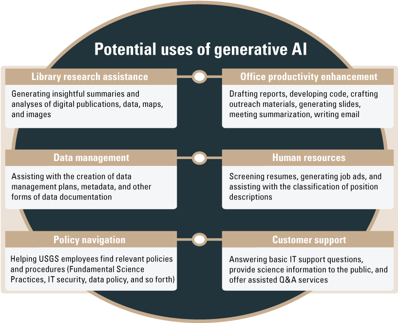
Examples of opportunities to use emerging generative AI capabilities, such as large-language models, to enhance business processes at the USGS.
In addition to the business-oriented examples given in figure 1, generative AI can be applied to modeling, data visualization, and other science activities. If used effectively, these opportunities could improve the USGS work experience and the quality, efficiency, fairness, and timeliness of our internal and external products. Such uses of AI are not yet widespread in USGS but are increasingly permeating organizations and businesses worldwide (Al-kfairy, 2025; Stanford Institute for Human-Centered Artificial Intelligence, 2025), such that the USGS will need to anticipate—and possibly benefit from—the fundamental shift that AI is driving in how work gets done.
Objective 1.3—Retain Talent
The retention of an AI-proficient workforce can be improved by supporting the career advancement and development of AI professionals and by continuing to foster a workplace where all employees have an opportunity to thrive through a culture of learning. Policies and practices that support the retention of AI talent could include the establishment of career advancement pathways for AI specialists and continued opportunities for mentorship, training, growth, and collaboration within and beyond the USGS.
Goal 2—Optimize Our Organizational Approach
Existing organizational structures at the USGS provide a strong start for governance and management of AI. By adapting our policies and procedures within those structures to address AI-specific needs and coordinating AI-related activities across those structures, the USGS can more efficiently meet Federal and departmental AI directives and support the set of goals outlined in this strategy (fig. 2).
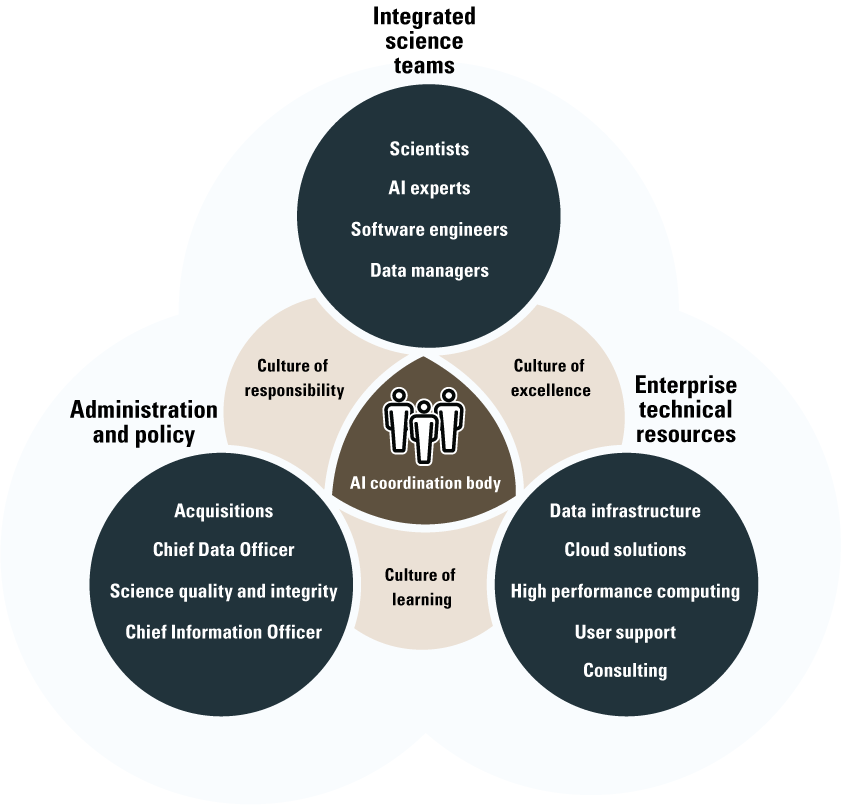
Diagram on how to structure an organization to embrace artificial intelligence. Adapted from General Services Administration (undated).
The USGS already has many of the components recommended in figure 2 in place. For example, (1) AI talent is embedded in our integrated science teams; (2) we have enterprise technical resources, including cloud-based services and high-performance computing; and (3) we have experts to offer guidance on legal, ethical, information technology security, data, acquisitions, human resources, and science quality and integrity. The USGS can change and adapt the policies and procedures guiding these structures to fully support AI adoption.
Objective 2.1—Adapt Policies and Procedures
Bureau-level policies and procedures (for example, those described by the Fundamental Science Practices Advisory Council, 2023) are fundamental to ensuring the scientific quality and integrity of AI development and use (refer to goal 3), information security for AI applications, and the information technology (IT) that supports AI (refer to goal 4). Many existing policies and procedures followed by the USGS are already broadly inclusive of AI-based science and technology, but adaptations may be needed as AI evolves, for example to address emerging questions such as intellectual property and quality assurance for AI-generated content, to build checklists for IT acquisitions experts and peer reviewers to assure the safety and quality of a new AI technology, or to remove unnecessary hurdles to AI adoption (refer also to goals 3 and 4). Coordination of these adaptations—for example, at the intersection of policies and IT tools for protecting private data or ensuring transparency of our AI applications—could help ensure that USGS staff can effectively use AI in the public’s best interests.
Objective 2.2—Communicate and Coordinate
Thorough and clear communication about USGS AI policies, resources, and activities can maximize the value of USGS AI investments to our mission delivery. A central coordination group could ensure robust communication and consistency across any new policies and technologies. An internal AI communication plan could give USGS staff anytime access to the information needed to use AI efficiently, responsibly, and collaboratively. An external AI communication plan could ensure that USGS AI activities are broadly visible and well represented in Federal AI data calls, interagency working groups, and innovative partnerships, and to the American public. Additionally, USGS leaders serving on departmental and Federal AI working groups could expand Bureau awareness of broader AI activities and opportunities.
Objective 2.3—Govern Effectively
Effective, coordinated governance of AI potentially will encourage innovation while providing guardrails to ensure robust, accurate, and useful AI applications. AI governance will likely also need to be flexible to accommodate diverse uses, emerging tools, and evolving best practices for AI. Governance of information technology coupled with appropriate data management and quality assurance can protect against inadvertent data leaks or other cybersecurity issues associated with AI applications and tools. The USGS's rigorous and thorough Fundamental Science Practices (Fundamental Science Practices Advisory Council, 2023) can enforce policies and best practices while encouraging cutting-edge techniques in AI development, use, and interpretation. Bottom-up governance can include training programs to equip researchers with techniques to use AI responsibly (refer to objective 1.2) and manage staff to foster a culture of personal accountability and proactive adoption of best practices for AI.
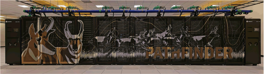
Photograph showing the Pathfinder supercomputer, the U.S. Geological Survey's most powerful system to date. It includes five graphics processing unit (GPU) nodes and is designed to meet the growing demands of Bureau researchers leveraging artificial intelligence. Photograph by Jeff Falgout, U.S. Geological Survey, January 6, 2026.
Goal 3—Ensure Responsible and Trustworthy AI
A comprehensive but balanced approach to the management of risks posed by the adoption of AI across the USGS can help maintain our gold standards of science quality and integrity while limiting barriers to innovation.
Objective 3.1—Manage Risk Comprehensively
AI has strong potential to enhance the quality and efficiency of USGS products and operations, but the use of AI also brings risks—some familiar, some unprecedented. A first step is to identify high-priority risks such as the production or promulgation of flawed data, incorrect interpretations of model outcomes, leaks of sensitive data, or adverse effects on civil rights, civil liberties, or privacy. Risks can be mitigated with ethical and technical guidelines encompassing data collection and management, algorithm design, model training and evaluation, publication, operational production, and communication practices for AI applications. Those guidelines can then be enforced through top-down and bottom-up governance (refer to objective 2.3) to a degree commensurate with the degree of risk and the USGS’s risk tolerance in each use of AI. AI risk management and governance frameworks (for example, NIST, 2023; AI Verify Foundation and Infocomm Media Development Authority, 2024; World Economic Forum [WEF], 2024) can be used to determine a balanced approach to risk, risk tolerance, and potential benefits of AI for the USGS.
Objective 3.2—Protect Scientific Integrity
AI, and especially generative AI, is transforming the way people do tasks, including writing code and reports, producing images and videos, and evaluating written materials. These applications raise new questions about intellectual property and scholarly integrity (Eke, 2023; Chesterman, 2025), and they introduce risks such that traditional quality assurance and quality control practices potentially will be insufficient for generative AI outputs (Freeman and others, 2025; Joshi, 2025). The USGS can reap the productivity benefits of AI while maintaining its gold standards of scientific integrity (Fundamental Science Practices Advisory Council, 2023; White House, 2025b,) by fostering a strong culture of human responsibility for all AI outputs (Blau and others, 2024), by attending to Federal and industry guidance on AI acquisition and management (for example, OMB, 2025c), and by adopting tools and best practices to proactively monitor for errors in AI output (NIST, 2023) and anticipate potential violations of intellectual property standards (Congressional Research Service, 2023).
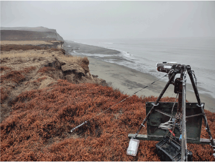
Photograph showing Cape Greig, Alaska, an area frequently used by walrus herds and that supports active fisheries managed by the State of Alaska. When sea ice is absent, walruses rest on shore, making them more vulnerable to disturbances that can trigger stampedes and lead to mass mortality. To address this, the U.S. Geological Survey is developing automated artificial-intelligence workflows that analyze photographs to rapidly detect walruses remotely, improving management decision timeliness while reducing staff workload (Fischbach, 2023). Photograph by Anthony Fischbach, May 9, 2023.
Objective 3.3—Ensure Transparency through Stakeholder Engagement
Like conventional techniques and approaches, AI has the potential to produce erroneous or even biased science predictions. Unlike conventional methods, the logic of AI tools can be difficult to explain and correct. The nontransparency of AI models thus raises new challenges for the USGS in earning the trust of stakeholders for our AI applications, despite our existing policies for publishing model code and outputs (Fundamental Science Practices Advisory Council, 2023). Engagement with stakeholders, partners, and the public may help the USGS avoid or mitigate potential flaws in AI applications that could affect the trust in, and thus utility of, our models and scientific products. To complement USGS’s existing peer review processes that are applied to all science products (Fundamental Science Practices Advisory Council, 2023), the proactive evaluation of AI models and tools to screen for flaws, along with explainable artificial intelligence (XAI) efforts to better understand and communicate our AI applications, models, and model outputs, may also strengthen the USGS’s mission delivery.
Goal 4—Modernize Technical Infrastructure
By expanding and modernizing our data and computing infrastructure to meet the common and emergent needs of AI projects, the USGS can help its staff to effectively and efficiently apply AI to deliver accurate and timely science products.
Objective 4.1—Upgrade Foundational Infrastructure
Accessible, high-quality data, advanced computing, cloud services, and high-speed research networks are essential for AI model development, training, and use. Training AI models requires access to large volumes of data on high-performance computing (HPC) systems with graphics processing units (GPUs) or neural processing units (NPUs) for massive parallelism (fig. 3). The successful adoption of some AI methods also potentially requires high-speed networks and data transfer tools to quickly and securely share large datasets among USGS facilities, cloud and on-premises computing environments, and partner research organizations. Stable and efficient provisioning of these resources, and the timely inclusion of new AI infrastructure as technologies advance, support the USGS in continuing our exploration, innovation, and effective development of AI methods.
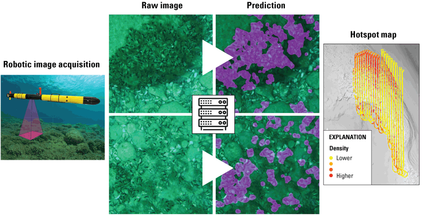
The U.S. Geological Survey (USGS) is using autonomous underwater vehicles (AUVs) and AI to survey invasive species in the Laurentian Great Lakes. (Figure from Peter Esselman, USGS, written commun., 2025.)
Custom machine-learning algorithms (forms of AI) have been trained to identify important lakebed-feature invasive species such as zebra and quagga mussels (Dreissena spp.; fig. 3). Big data pipelines have been engineered to use the USGS’s high-performance computing systems (Falgout and others, 2025) to summarize ecosystem patterns for more than 3,000 kilometers of AUV transects completed to date, comprising more than 2 million images. The results can be used to inform decisions about predator stocking and invasive species control.
Objective 4.2—Facilitate Exploration and Discovery
Creating environments in which the USGS can test new technologies, including third-party tools, supports our emerging science and operational activities. These technologies range from basic AI-ready programming languages to fully trained AI models with user-friendly software. The proactive, rapid review and approval of emerging third-party AI tools and services—and in-house tools built on these technologies—can help USGS staff understand the strengths, weaknesses, and risks of these new systems and may help expand creative thinking related to science products, end-user applications, and Bureau operations.
Objective 4.3—Share High-Quality Data and AI Advances
Recent Federal guidance (Office of Management and Budget [OMB], 2025b) directs agencies to “actively engag[e] in quality data governance and management and the reuse of data and AI assets” to ensure efficient use of resources. Consistent with this directive, the USGS Data Strategy emphasizes the importance of providing unbiased, accessible, high-quality, and interoperable data to better serve societal needs (Hutchison and others, 2024). Such well-managed data can ensure the development of trustworthy AI-enabled science products. Once developed, USGS data and AI products can be most effectively reused if dissemination follows the principles of “findable, accessible, interoperable, and reusable (FAIR),” which also improve transparency and reuse across the scientific community and public through their alignment with open science (National Academies of Sciences, Engineering, and Medicine, 2018), and “open, public, electronic, and necessary (OPEN)” government data (OMB, 2025a). Further, the use and development of enterprise tools for efficiently sharing AI models, model metadata, training data, code, and publications could allow the USGS to better leverage and contribute to AI expertise and capabilities within the broader science community, and could reduce the duplication of effort and support knowledge sharing across the Bureau.
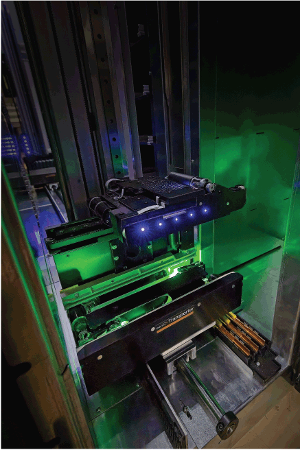
Photograph showing the robotic transporter arm inside the Grizzly storage system, which is designed to store up to 185 petabytes of compressed research data. Photograph by Jeff Falgout, U.S. Geological Survey, January 6, 2026.
Goal 5—Accelerate AI Adoption and Innovation
By vigorously promoting AI adoption and innovation where AI has potential to be the best tool for the job, the USGS can maintain and strengthen its leadership in the provision of high-quality Earth system monitoring, analysis, prediction, and delivery of actionable intelligence for societal needs.
Objective 5.1—Prioritize and Incentivize AI Adoption
To encourage AI adoption, AI-based approaches can be prioritized relative to comparable alternatives during the planning and selection of new projects. Recognition programs can highlight and incentivize innovative AI advancements. Innovation can also be spurred by initiating and supporting participation in public AI competitions, granting seed funding for high-potential pilot projects, sponsoring AI-focused interns and fellows, and providing AI innovators across the USGS with subsidized access to computing resources and third-party AI tools (refer to objectives 4.1 and 4.2).
Objective 5.2—Support AI Research and Development
An AI user support and consulting capability composed of cross-functional teams of AI specialists, data scientists, software engineers, high-performance computing experts, and information technology (IT) specialists working with domain experts can facilitate the development of AI solutions that are creative, robust, and scalable. Providing comprehensive technical support can spur the adoption and use of AI, broaden the understanding of available resources and emergent needs, and enhance proficiency in AI and AI-driven research across the USGS. A holistic support approach can also facilitate the effective transition of AI research into operational capabilities that support the USGS mission (for an example, refer to fig. 4).
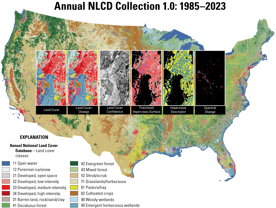
Example of U.S. Geological Survey operational data production using artificial intelligence. Annual National Land Cover Database (NLCD) products are created using deep-learning algorithms (U.S. Geological Survey, 2024).
Objective 5.3—Collaborate with the AI Community
Synergistic collaborations and partnerships can accelerate innovation and enhance scientific advancements. The USGS can continue to actively engage and build strategic alliances with academia, industry, national laboratories, other agencies, international organizations, and AI communities of practice. By leveraging external AI expertise and sharing unique USGS contributions, a reciprocal exchange of knowledge can be fostered to build partnerships. This may strengthen USGS AI innovation and leadership, especially in key domains such as geospatial and Earth sciences, ultimately increasing the effectiveness of USGS mission delivery.
Summary
The strategic plan described in this report calls for a multipronged approach to enable effective, responsible, and innovative integration of artificial intelligence (AI) into U.S. Geological Survey (USGS) science and business practices. Although AI is only one set of tools among many that the USGS can use to support its mission—and one that brings new risks and challenges to manage—AI could improve the quality, timeliness, and breadth of our science products. The five goals outlined in this report reflect the expectation that the USGS’s capability to responsibly develop and leverage AI will be synergistically enhanced by attention to the Bureau’s staff, technology, organizational culture, structures, policies, and procedures. An implementation plan can identify measurable objectives specific to each mission area and region to achieve this strategic vision. As the field of AI grows and changes, this strategy and the details of its implementation can be updated to meet emergent challenges and opportunities in AI. Above all, an agile and proactive approach can help ensure that AI can be leveraged safely, securely, responsibly, and innovatively to enhance the USGS’s service to the American public.

Photograph showing more than 1,500 walruses resting on shore at Cape Grieg in southeastern Bristol Bay, Alaska. Photograph by U.S. Geological Survey, April 4, 2016.
Acknowledgments
The authors thank Anne Kinsinger and Jennifer Lacey for providing leadership as the executive sponsors for this project. Paul Exter, Dr. Michael Tischler, and Bill Werkheiser are thanked for providing subject matter expertise for this project.
References Cited
AI Verify Foundation and Infocomm Media Development Authority, 2024, Model AI governance framework for generative AI—Fostering a trusted ecosystem: AI Verify Foundation and IMDA, accessed February 10, 2025, at https://aiverifyfoundation.sg/wp-content/uploads/2024/06/Model-AI-Governance-Framework-for-Generative-AI-19-June-2024.pdf.
Ali, S., Abuhmed, T., El-Sappagh, S., Muhammad, K., Alonso, J.M., Confalonieri, R., Guidotti, R., Del Ser, J., Díaz-Rodríguez, N., and Herrera, F., 2023, Explainable artificial intelligence (XAI)—What we know and what is left to attain Trustworthy Artificial Intelligence: Information Fusion, v. 99, no. 3, 52 p., accessed February 10, 2025, at http://doi.org/10.1016/j.inffus.2023.101805.
Al-kfairy, M., 2025, Strategic Integration of Generative AI in Organizational Settings: Applications, Challenges and Adoption Requirements, IEEE Engineering Management Review, accessed November 18, 2025, at https://doi.org/10.1109/EMR.2025.3534034.
Blau, W., Cerf, V.G., Enriquez, J., Francisco, J.S., Gasser, U., Gray, M.L., Greaves, M., Grosz, B.J., Jamieson, K.H., Haug, G.H., Hennessy, J.L., Horvitz, E., Kaiser, D.I., London, A.J., Lovell-Badge, R., McNutt, M.K., Minow, M., Mitchell, T.M., Ness, S., Parthasarathy, S., Perlmutter, S., Press, W.H., Wing, J.M., and Witherell, M., 2024, Protecting scientific integrity in an age of generative AI: Proceedings of the National Academy of Sciences of the United States of America, v. 121, no. 22, art. e2407886121, 3 p., accessed February 10, 2025, at https://doi.org/10.1073/pnas.2407886121.
Buscombe, D., Wernette, P., Fitzpatrick, S., Favela, J., Goldstein, E.B., and Enwright, N.M., 2023, A 1.2 billion pixel human-labeled dataset for data-driven classification of coastal environments: Scientific Data, v. 10, art. 46, 18 p. [Also available at https://doi.org/10.1038/s41597-023-01929-2.]
Cartwright, J., Morelli, T.L., and Grant, E.H.C., 2022, Identifying climate‐resistant vernal pools—Hydrologic refugia for amphibian reproduction under droughts and climate change: Ecohydrology, v. 15, no. 5, art. e2354, 23 p., accessed February 10, 2025, at https://doi.org/10.1002/eco.2354.
Chesterman, S., 2025, Good models borrow, great models steal—Intellectual property rights and generative AI: Policy and Society, v. 44, no. 1, p. 23–37, accessed July 30, 2025, at https://doi.org/10.1093/polsoc/puae006.
Congressional Research Service, 2023, Generative artificial intelligence and copyright law: Congress.gov web page, accessed July 26, 2024, at https://www.congress.gov/crs-product/LSB10922.
Dell’Acqua, F., McFowland, E., III, Mollick, E.R., Lifshitz-Assaf, H., Kellogg, K., Rajendran, S., Krayer, L., Candelon, F., and Lakhani, K.R., 2023, Navigating the jagged technological frontier—Field experimental evidence of the effects of AI on knowledge worker productivity and quality: Harvard Business School, 58 p. [Also available at https://doi.org/10.2139/ssrn.4573321.]
Eke, D.O., 2023, ChatGPT and the rise of generative AI—Threat to academic integrity?: Journal of Responsible Technology, v. 13, art. 100060, 4 p., accessed July 31, 2025 at https://doi.org/10.1016/j.jrt.2023.100060.
Falgout, J.T., Gordon, J.M., Lee, R.L., and Williams, B.T., 2025, USGS Hovenweep Supercomputer: U.S. Geological Survey web page, accessed November, 19, 2025, at https://doi.org/10.5066/P927BI7R.
Feron, S., Malhotra, A., Bansal, S., Fluet‐Chouinard, E., McNicol, G., Knox, S.H., Delwiche, K.B., Cordero, R.R., Ouyang, Z., Zhang, Z., Poulter, B., and Jackson, R.B., 2023, Recent increases in annual, seasonal, and extreme methane fluxes driven by changes in climate and vegetation in boreal and temperate wetland ecosystems: Global Change Biology, v. 30, no. 1, art. e17131, 18 p. [Also available at https://doi.org/10.1111/gcb.17131.]
Fischbach, A.S., 2023, Pacific walrus coastal haulout images from remote camera stations (ver. 2.0, January 2024): U.S. Geological Survey data release, https://doi.org/10.5066/F7XW4H88.
Freeman, L., Robert, J., and Wojton, H., 2025, The impact of generative AI on test & evaluation—Challenges and opportunities, in FSE companion ’25—Proceedings of the 33rd ACM International Conference on the Foundations of Software Engineering, Trondheim, Norway, June 2325, 2025: New York, Association for Computing Machinery, p. 1376–1380, accessed July 31, 2025, at https://doi.org/10.1145/3696630.3728723.
Fundamental Science Practices Advisory Council, 2023, Update on U.S. Geological Survey Fundamental Science Practices: U.S. Geological Survey Circular 1503, 6 p., accessed February 10, 2025, at https://doi.org/10.3133/cir1503.
General Services Administration, [undated], AI guide for government—A living and evolving guide to the application of artificial intelligence for the U.S. Federal Government: General Services Administration Centers of Excellence website, accessed June 2024 at https://coe.gsa.gov/coe/ai-guide-for-government.
General Services Administration, 2025, Artificial intelligence community of practice, accessed November 17, 2025, at https://www.gsa.gov/technology/government-it-initiatives/artificial-intelligence/ai-community-of-practice.
Guinand, B., Topchy, A., Page, K.S., Burnham-Curtis, M.K., Punch, W.F., and Scribner, K.T., 2002, Comparisons of likelihood and machine learning methods of individual classification, Journal of Heredity, v. 93, no. 4, p. 260–269, accessed July 26, 2024 at https://doi.org/10.1093/jhered/93.4.260.
Hsu, L., Liford, A.N., and Donovan, G.C., 2022, Community for data integration 2020 annual report: U.S. Geological Survey Open-File Report 2022–1034, 16 p., accessed November 17, 2025, at https://doi.org/10.3133/ofr20221034.
Huang, C., Davis, L.S., and Townshend, J.R.G., 2010, An assessment of support vector machines for land cover classification: International Journal of Remote Sensing, v. 23, no. 4, p. 725–749. [Also available at https://doi.org/10.1080/01431160110040323.]
Hutchison, V.B., Burley, T.E., Blasch, K.W., Exter, P.E., Gunther, G.L., Shipman, A.J., Kelley, C.M., and Morris, C.A., 2024, U.S. Geological Survey Data Strategy 2023–33: U.S. Geological Survey Circular 1517, 7 p., accessed February 10, 2025, at https://doi.org/10.3133/cir1517.
IBM and NASA, 2023, Prithvi-E0-1.0-100M (vers. 489bb56): Hugging Face, accessed February 10, 2025, at https://doi.org/10.57967/HF/0952.
Joshi, S., 2025, Model risk management in the era of generative AI—Challenges, opportunities, and future directions: International Journal of Scientific and Research Publications, v. 15, no. 5, p. 299–309, accessed July 31, 2025, at https://philarchive.org/rec/JOSMRM.
Lawley, C.J.M., McCafferty, A.E., Graham, G.E., Huston, D.L., Kelley, K.D., Czarnota, K., Paradis, S., Peter, J.M., Hayward, N., Barlow, M., Emsbo, P., Coyan, J., San Juan, C.A., and Gadd, M.G., 2022, Data-driven prospectivity modelling of sediment-hosted Zn-Pb mineral systems and their critical raw materials: Ore Geology Reviews, v. 141, art. 104635, 23 p. [Also available at https://doi.org/10.1016/j.oregeorev.2021.104635.]
Lederer, G., Rosera, J., Goldman, M., Graham, G., Mishra, A., Towler, A., Wilson, B., Graf, D., Milano, M., Roberts, E., Hedrick, G., Oertel, C., Dardas, A., and McEntee, T., 2022, Automated georeferencing and feature extraction of geologic maps and mineral sites, in Knobloch, A., Torppa, J., and Chudasama, B., eds., MinProXT 2022—Mineral prospectivity and exploration targeting, Abstract proceedings: Geological Survey of Finland GTK Open File Research Report 29/2023, p. 8–10, accessed July 26, 2024, at https://eis-he.eu/images/delivrables/29_2023.pdf.
Lemeshewsky, G., 1997, Neural network method for sharpening Landsat thermal data from higher resolution multispectral data: U.S. Geological Survey Open-File Report 97–301, 18 p., accessed July 26, 2024, at https://doi.org/10.3133/ofr97301.
Li, W., Arundel, S., Gao, S., Goodchild, M., Hu, Y., Wang, S., and Zipf, A., 2024, GeoAI for Science and the Science of GeoAI: Journal of Spatial Information Science, v. 29, p. 1–17. [Also available at https://doi.org/10.5311/JOSIS.2024.29.349.]
Miller, T., 2019, Explanation in artificial intelligence—Insights from the social sciences: Artificial Intelligence, v. 267, p. 1–38. [Also available at https://doi.org/10.1016/j.artint.2018.07.007.]
National Academies of Sciences, Engineering, and Medicine, 2018, Open science by design—Realizing a vision for 21st century research: Washington, D.C., The National Academies Press, 232 p. [Also available at https://doi.org/10.17226/25116.]
National Institute of Standards and Technology [NIST], 2023, Artificial intelligence risk management framework (AI RMF 1.0): U.S. Department of Commerce, 42 p., accessed July 26, 2024, at https://doi.org/10.6028/NIST.AI.100-1.
Severson, J.P., Vosburgh, T.C., and Johnson, H.E., 2023, Effects of vehicle traffic on space use and road crossings of caribou in the Arctic: Ecological Applications, v. 33, no. 8, art. e2923, 21 p. [Also available at https://doi.org/10.1002/eap.2923.]
Singer, D.A., and Kouda, R., 1997, Classification of mineral deposits into types using mineralogy with a probabilistic neural network: Nonrenewable Resources, v. 6, p. 27–32. [Also available at https://doi.org/10.1007/BF02816922.]
Stanford Institute for Human-Centered Artificial Intelligence, 2025, Artificial intelligence index report 2025: Stanford Institute for Human-Centered Artificial Intelligence web page, 456 p., accessed November 18, 2025, at https://doi.org/10.48550/arXiv.2504.07139.
Sur, M., Hall, J.C., Brandt, J., Astell, M., Poessel, S.A., and Katzner, T.E., 2023, Supervised versus unsupervised approaches to classification of accelerometry data: Ecology and Evolution, v. 13, no. 5, art. e10035, 11 p. [Also available at https://doi.org/10.1002/ece3.10035.]
U.S. Congress, 2020, National Artificial Intelligence Initiative, chapter 119, title 15, section 9401, subsection 3 (15 U.S.C. 9401[3]): Office of the Law Revision Counsel webpage, accessed July 26, 2024, at https://uscode.house.gov/view.xhtml?req=(title:15%20section:9401%20).
U.S. Geological Survey, 2021, U.S. Geological Survey 21st-century science strategy 2020–2030: U.S. Geological Survey Circular 1476, 20 p., accessed July 26, 2024 at https://doi.org/10.3133/cir1476.
U.S. Geological Survey, 2024 Annual NLCD Product Suite: U.S. Geological Survey web page, accessed October 8, 2024, at https://www.usgs.gov/centers/eros/science/nlcd-product-suite
U.S. Office of Personnel Management, 2024, Memorandum CPM 2024-06, Pay flexibility, incentive pay, and leave and workforce flexibility programs for artificial intelligence (AI), AI-enabling, and other key technical employees: Chief Human Capital Officers webpage, 7 p., accessed June 3, 2025, at https://chcoc.gov/sites/default/files/Memo%20on%20Pay%20Leave%20Workforce%20Flexibilities%20for%20AI%20AI%20Enabling%20and%20Other%20Technical%20Talen t.pdf.
U.S. Office of Management and Budget [OMB], 2025a, Memorandum M-25-05, Phase 2 implementation of the Foundations for Evidence-Based Policymaking Act of 2018—Open government data access and management guidance: Executive Office of the President, 32 p., accessed June 3, 2025, at https://bidenwhitehouse.archives.gov/wp-content/uploads/2025/01/M-25-05-Phase-2-Implementation-of-the-Foundations-for-Evidence-Based-Policymaking-Act- of-2018-Open-Government-Data-Access-and-Management-Guidance.pdf.
U.S. Office of Management and Budget [OMB], 2025b, Memorandum M-25-21, Accelerating Federal use of AI through innovation, governance, and public trust: Executive Office of the President, 25 p., accessed May 30, 2025, at https://www.whitehouse.gov/wp-content/uploads/2025/02/M-25-21-Accelerating-Federal-Use-of-AI-through-Innovation-Governance-and-Public-Trust.pdf.
U.S. Office of Management and Budget [OMB], 2025c, Memorandum M-25-22, Driving efficient acquisition of artificial intelligence in government: Executive Office of the President, 13 p., accessed June 3, 2025, at https://www.whitehouse.gov/wp-content/uploads/2025/02/M-25-22-Driving-Efficient-Acquisition-of-Artificial-Intelligence-in-Government.pdf.
Waddle, J.H., Thigpen, T.F., and Glorioso, B.M., 2009, Efficacy of automatic vocalization recognition software for anuran monitoring: Herpetological Conservation and Biology, v. 4, no. 3, p. 384–388. [Also available at https://www.herpconbio.org/Volume_4/Issue_3/Waddle_etal_2009.pdf.]
Wang, X., Liu, S., Tsaris, A., Choi, J.-Y., Aji, A.M., Fan, M., Zhang, W., Yin, J., Ashfaq, M., Lu, D., and Balaprakash, P., 2024, ORBIT—Oak ridge base foundation model for Earth system predictability (vers. 5): Cornell University arxiv, 13 p., accessed February 10, 2025, at https://doi.org/10.48550/arXiv.2404.14712.
Wells, A.G., Munson, S.M., Sesnie, S.E., and Villarreal, M.L., 2021, Remotely sensed fine-fuel changes from wildfire and prescribed fire in a semi-arid grassland: Fire, v. 4, no. 4, 22 p. [Also available at https://doi.org/10.3390/fire4040084.]
White House, 2025a, Executive Order 14179—Removing barriers to American leadership in artificial intelligence: Federal Register, v. 90, no. 20, p. 8741–8742, accessed February 10, 2025, at https://www.federalregister.gov/d/2025-02172.
White House, 2025b, Executive Order 14303—Restoring gold standard science: Federal Register, v. 90, no. 102, p. 22601–22606, accessed June 3, 2025, at https://www.federalregister.gov/d/2025-09802.
World Economic Forum [WEF], 2024, Governance in the age of generative AI—A 360° approach for resilient policy and regulation [White Paper]: World Economic Forum web page, 36 p., accessed February 10, 2025, at https://www3.weforum.org/docs/WEF_Governance_in_the_Age_of_Generative_AI_2024.pdf
Yeck, W.L., Patton, J.M., Ross, Z.E., Hayes, G.P., Guy, M.R., Ambruz, N.B., Shelly, D.R., Benz, H.M., and Earle, P.S., 2021, Leveraging deep learning in global 24/7 real-time earthquake monitoring at the National Earthquake Information Center: Seismological Research Letters, v. 92, no. 1, p. 469–480. [Also available at https://doi.org/10.1785/0220200178.]
Zwart, J.A., Diaz, J., Hamshaw, S., Oliver, S., Ross, J.C., Sleckman, M., Appling, A.P., Corson-Dosch, H., Jia, X., Read, J., Sadler, J., Thompson, T., Watkins, D., and White, E., 2023, Evaluating deep learning architecture and data assimilation for improving water temperature forecasts at unmonitored locations: Frontiers in Water, v. 5, art. 1184992, 18 p. [Also available at https://doi.org/10.3389/frwa.2023.1184992.]
Glossary
- explainable artificial intelligence (XAI)
Explainable artificial intelligence refers to the area of research and practice that aims to provide transparency to AI models and their outputs through explanations that are understandable at an acceptable level to human users (Miller, 2019; Ali and others, 2023).
- foundation model
An AI model trained on a vast amount of data so that the model can easily be adapted for a wide range of general tasks, including to generate text or other outputs (refer to the Glossary entry for “generative AI”).
- generative AI
The class of AI models that emulate the structure and characteristics of input data in order to generate derived synthetic content. This can include images, videos, audio, text, and other digital content.
- high-performance computing (HPC)
Refers to the use of powerful computing systems—often called supercomputers—to solve large, complex problems that require substantial computational resources. These systems aggregate computing power through parallel processing (refer to Glossary entry for “parallelism”), where many calculations are performed simultaneously across multiple processors. HPC systems are supported by specialized hardware and high-speed interconnection networks, enabling them to process massive datasets and perform sophisticated simulations or analyses far beyond the capabilities of standard computers.
- large-language model (LLM)
A generative AI model trained on massive corpuses of text, images, and (or) videos.
- machine learning (ML)
A set of techniques that can be used to train AI algorithms to improve performance of a task based on data (U.S. Congress, 2020).
- parallelism
Also known as parallel processing or parallel computing, parallelism is a computational approach where large problems are divided into smaller tasks that are executed simultaneously across multiple processors. This technique is widely used in AI model training using specialized chips designed for parallel execution.
For more information concerning the research in this report, contact the
Center Director, USGS Science Analytics and Synthesis Program
P.O. Box 25046, Mail Stop 302
Denver, CO 80225
Or visit the Science Analytics and Synthesis Program website at
https://www.usgs.gov/programs/science-analytics-and-synthesis-sas
Publishing support provided by the Science Publishing Network,
Denver and Rolla Publishing Service Centers
Disclaimers
Any use of trade, firm, or product names is for descriptive purposes only and does not imply endorsement by the U.S. Government.
Although this information product, for the most part, is in the public domain, it also may contain copyrighted materials as noted in the text. Permission to reproduce copyrighted items must be secured from the copyright owner.
Suggested Citation
Gordon, J.M., Appling, A.P., Aretxabaleta, A., Bechtell, J.F., Burley, T.E., Carter, J.M., Esselman, P.C., Fisher, J.C., Lederer, G.W., Mitchell, J.M., Pastick, N.J., Weltzin, J., and Woods, T., 2026, Artificial intelligence strategy for the U.S. Geological Survey: U.S. Geological Survey Circular 1562, 14 p., https://doi.org/10.3133/cir1562.
ISSN: 2330-5703 (online)
| Publication type | Report |
|---|---|
| Publication Subtype | USGS Numbered Series |
| Title | Artificial intelligence strategy for the U.S. Geological Survey |
| Series title | Circular |
| Series number | 1562 |
| DOI | 10.3133/cir1562 |
| Publication Date | February 18, 2026 |
| Year Published | 2026 |
| Language | English |
| Publisher | U.S. Geological Survey |
| Publisher location | Reston VA |
| Contributing office(s) | Science Analytics and Synthesis |
| Description | iv, 14 p. |
| Online Only (Y/N) | Y |