

Woods Hole Coastal and Marine Science Center—2024 Annual Report
Links
- Document: Report (39 MB pdf) , HTML , XML
- Download citation as: RIS | Dublin Core
Our Mission
Preparing the Nation for coastal and ocean changes.
-
• 40% of the U.S. population lives in coastal counties.
-
• 54.6 million people employed in coastal counties annually.
-
• $10 trillion in goods and services produced in coastal counties annually.
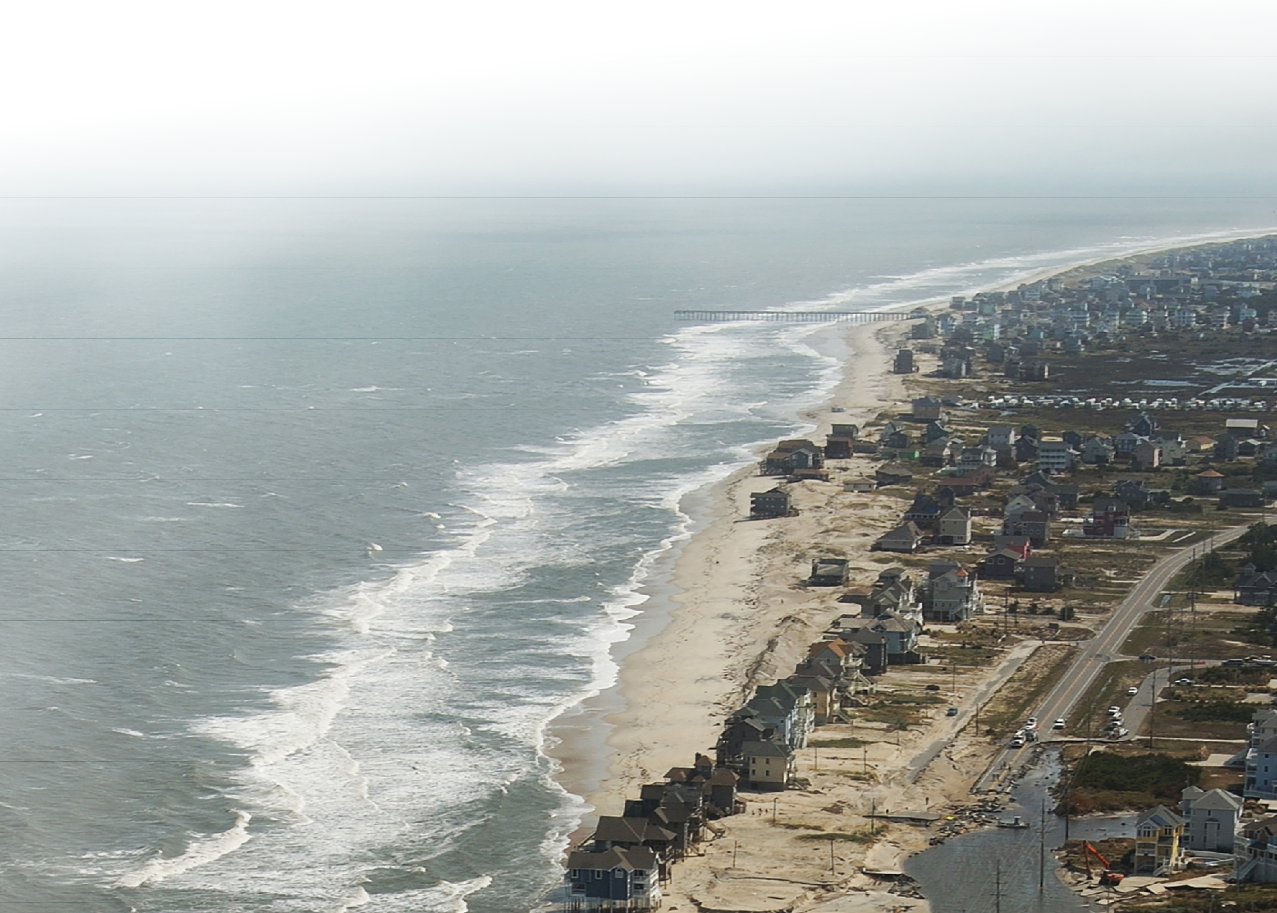
A breach in the coastline of Rodanthe, North Carolina, caused by Hurricane Irene in 2011. Repeated storm impacts, combined with sea-level rise, make the development and improvement of models that help forecast coastal change important to planners working to build more resilient communities.
As coastal populations continue to increase, more people, infrastructure, and ecosystems will be threatened by storms, sea-level rise, and tsunamis. Growing worldwide demand for natural resources will increase our dependence on the goods and services provided by coastal and ocean environments.
The U.S. Geological Survey (USGS) Coastal and Marine Hazards and Resources Program (CMHRP) is the Federal science program dedicated to providing knowledge and science-based tools that lead to safer, more productive coastal communities and improved stewardship of natural resources.
The USGS Woods Hole Coastal and Marine Science Center (WHCMSC) in Woods Hole, Massachusetts, is one of three centers serving the mission of the USGS CMHRP. The center’s staff of about 100 conducts scientific research across the United States and internationally to understand the persistent processes and extreme events shaping coastal and marine systems, from the deep sea to the continental shelf, beaches, salt marshes, and the Great Lakes. Management decisions that are guided by this research can minimize negative consequences to people, ecosystems, and the economy.
This annual report summarizes the work of the WHCMSC and highlights accomplishments from fiscal year 2024—October 1, 2023–September 30, 2024.
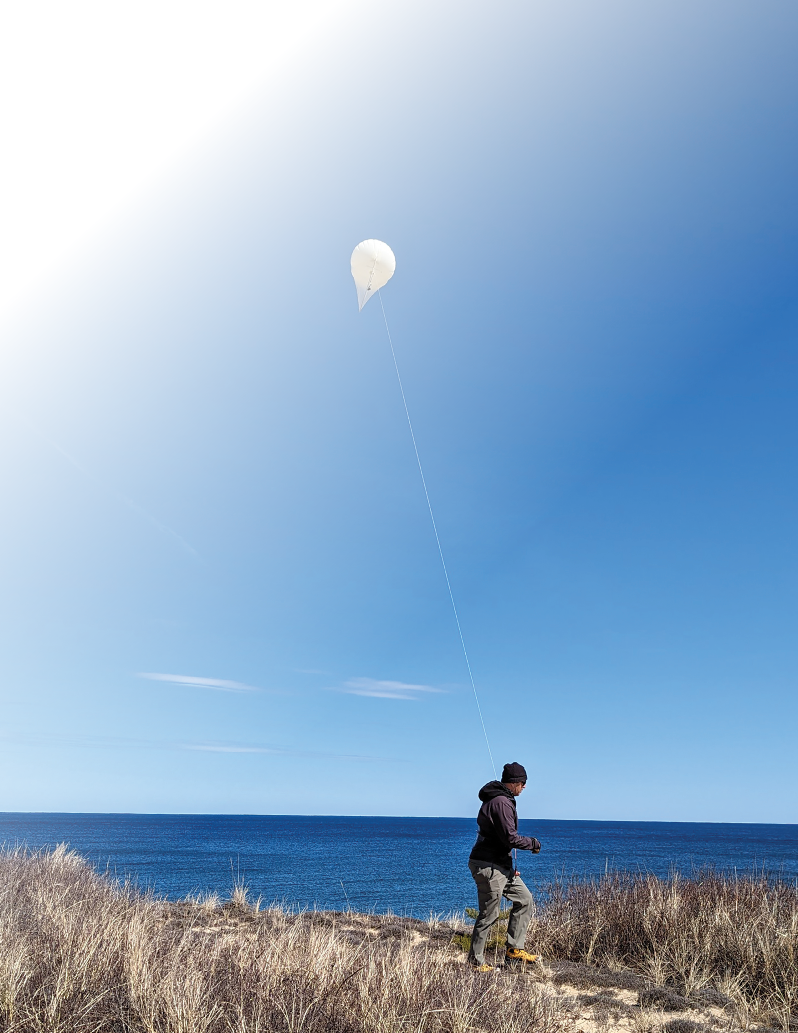
U.S. Geological Survey and Woods Hole Oceanographic Institution scientists use a helikite at Marconi Beach in Wellfleet, Massachusetts, to collect images of the coastline. The pictures collected by these helium-powered kite-balloons were used to create a three-dimensional digital elevation map of the beach.
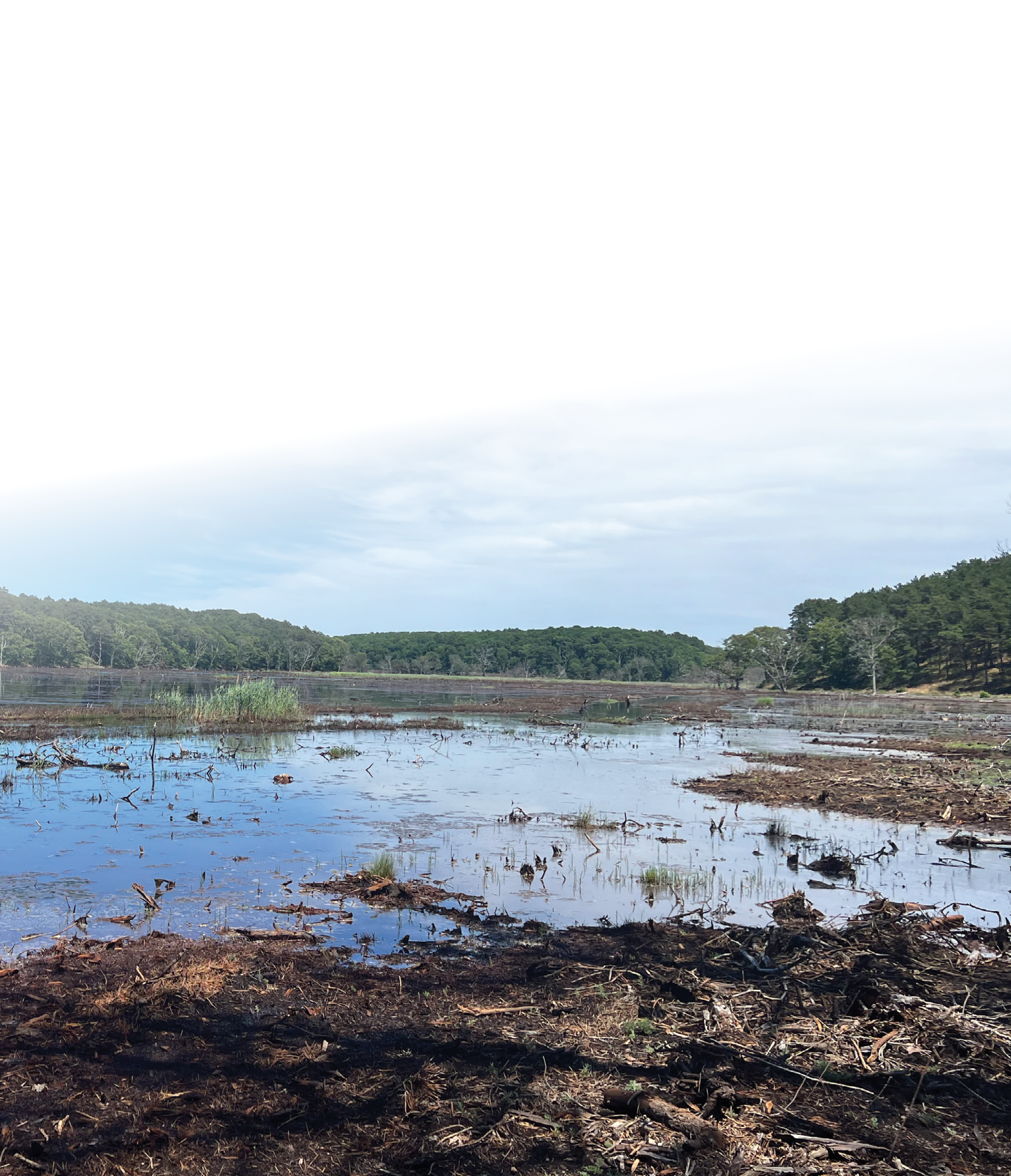
Herring River estuary in Wellfleet, Massachusetts. For a decade, the U.S. Geological Survey has conducted blue carbon research to support the Herring River restoration project and determine the carbon cycle response to rising sea levels under both restored and diked wetland scenarios.
Science Highlights
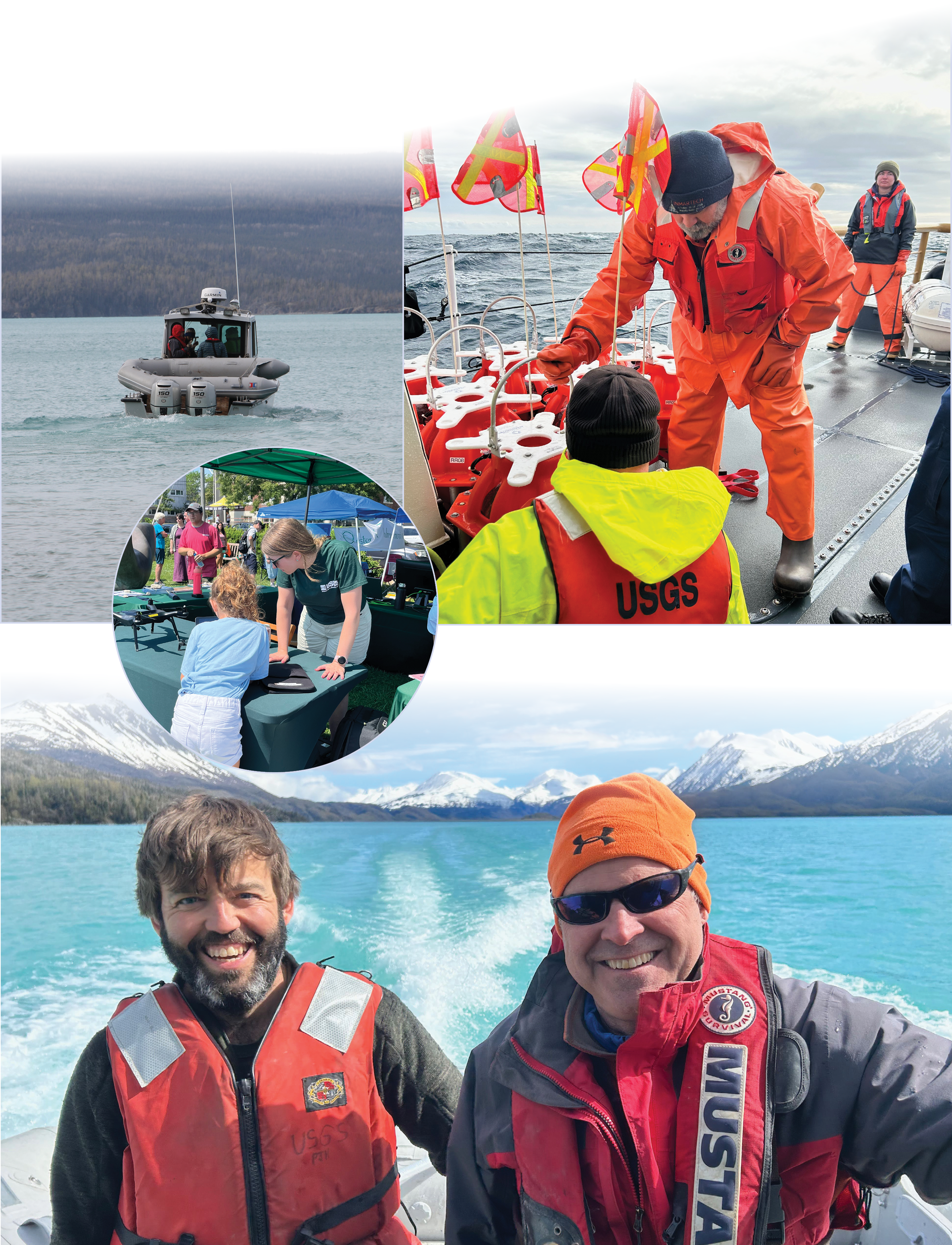
[Top left] The research vessel Lutris on Skilak Lake, Alaska, where scientists are working to create a record of past earthquakes. [Top right] Wayne Baldwin and Eric Moore of the U.S. Geological Survey preparing the rapid response ocean bottom seismograph fleet for deployment. [Middle left] U.S. Geological Survey geographer Jen Cramer showing off our uncrewed aircraft system technology at the Woods Hole Science Stroll in Woods Hole, Massachusetts. [Bottom] U.S. Geological Survey scientists Nathan Miller and Brian Andrews on Skilak Lake, Alaska, as part of a USGS collaboration with partners from the Woods Hole Oceanographic Institution to create a record of past earthquakes.
U.S. Extended Continental Shelf Outer Limit Coordinates Announced
The USGS is part of a Federal interagency effort to identify the outer limits of the U.S. extended continental shelf (ECS)—the area beyond 200 nautical miles from shore where the United States can manage marine resources. The U.S. ECS outer limits were publicly announced in December 2023 for the first time. The area is approximately 1 million square kilometers—about twice the size of California—spread across seven regions: the Arctic, Atlantic (east coast), Bering Sea, Pacific (west coast), Mariana Islands, and two regions in the Gulf of America. The USGS led efforts concerning seismic and geologic data, including leading or participating in 10 major research expeditions, during which more than 28,000 kilometers of sea-floor subbottom data were collected.
Reimbursable Funding for Coastal Change Products Secured
Reimbursable funding was secured from the U.S. Department of Defense to expand the Coastal Change Likelihood and Coastal Response Likelihood product suite to the southeastern Atlantic coast. The Coastal Change Likelihood assessment determines the future likelihood of coastal change. The Coastal Response Likelihood assessment predicts coastal response to sea-level rise under a range of future scenarios. Additional reimbursable funding was secured through the USGS Northeast Climate Adaptation Science Center to explore the usability of landscape change products with coastal managers.
National Shoreline Change Data Catalog Created
The National Shoreline Change Data Catalog—a single location for accessing USGS national shoreline datasets—was created. The catalog was added to the center's ScienceBase community page and is organized by State to make shoreline data easier to find. New shoreline data are added after publication. These data can help coastal managers identify areas of the coast that are most likely to experience significant change over time.
Rapid-Response Ocean-Bottom Seismograph Fleet Developed and Tested
The USGS partnered with the Woods Hole Oceanographic Institution (WHOI) Ocean Bottom Seismic Instrument Center to create and operate a fleet of small ocean-bottom seismographs dedicated to rapid-response efforts. While traditional ocean-bottom seismographs typically take more than 100 days to deploy after a major seismic event due to their massive size and transportation requirements, this new fleet is specifically designed for quick mobilization within 2 weeks of an event. The rapid-response fleet advances our capabilities for natural hazards research and will allow us to record seismic events during periods of exceptionally high scientific value. The fleet was successfully tested offshore Cape Cod, Massachusetts. A response plan for providing on-call staff and equipment for rapid deployments in response to major marine geohazards is being developed.
Student and Early Career Mentorships
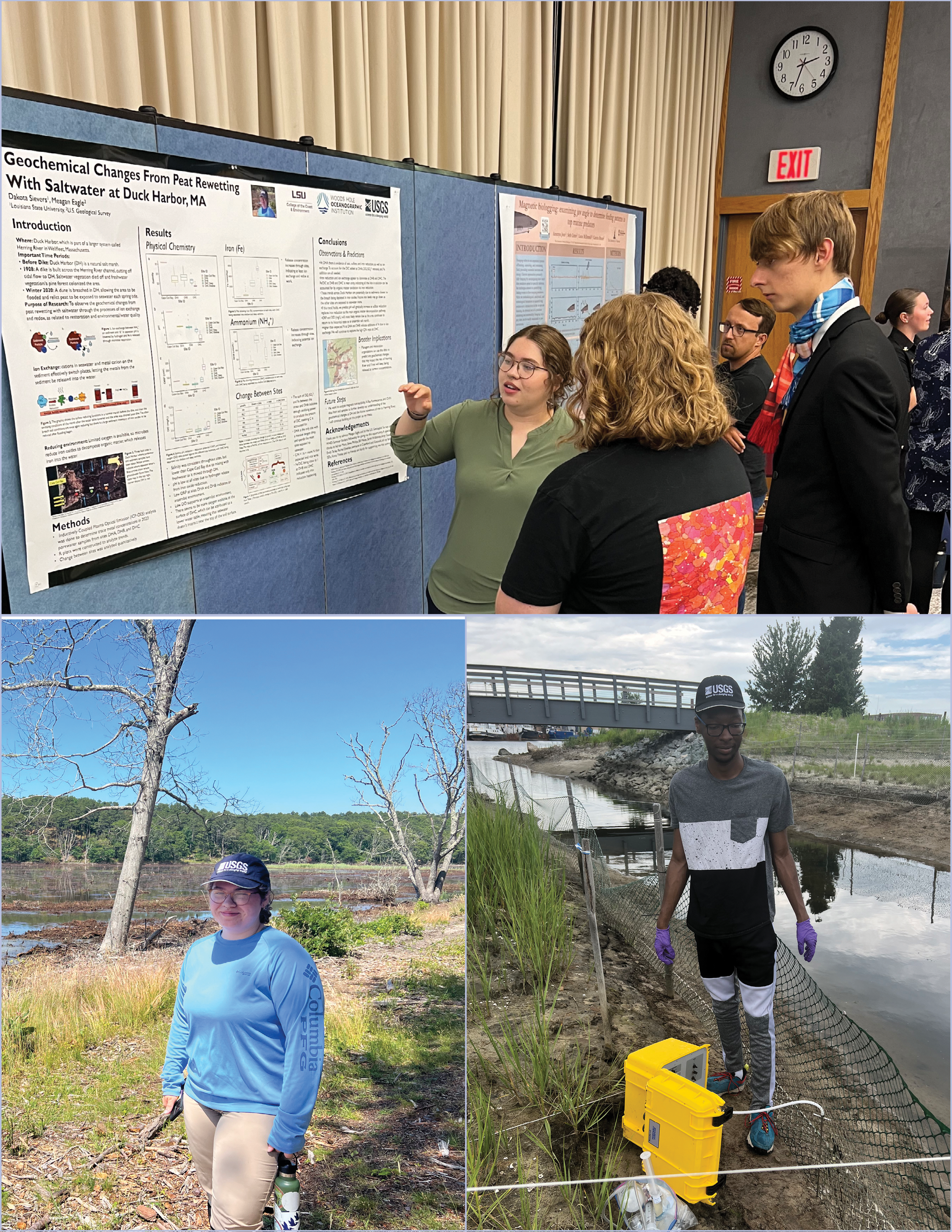
[Top] U.S. Geological Survey (USGS) intern Dakota Sievers shares the results of her summer research project with community members. Dakota’s project evaluated the geochemical changes occurring at the Herring River, part of the Cape Cod National Seashore, after the site was flooded with seawater for the first time in over a century. [Bottom left] USGS intern Dakota Sievers conducts fieldwork at Herring River as part of her summer research project. This portion of the wetland was restricted from tidal flow more than 100 years ago, but seawater was reintroduced in 2020 when a dune was breached during a winter storm. Now the wetland floods regularly, and the ecosystem is changing rapidly. [Bottom right] USGS and Partnership Education Program intern Amari Johnson collects porewater samples from Marsh Island, a marsh that was recently constructed in Fairhaven, Massachusetts. Amari studied the exchange of water between the adjacent harbor and the new marsh. The marsh was intentionally built at an elevation high in the tidal frame, to provide habitat for species such as the salt marsh sparrow. Evaluating the hydrology and chemistry of the new marsh is important for managers as they track vegetation growth and habitat.
Scientists at the center mentor students and recent graduates through programs such as the WHOI Summer Student Fellowship (SSF), the Woods Hole Partnership Education Program (PEP), the City College of New York/City University of New York partnership, and the USGS/National Association of Geoscience Teachers Cooperative Summer Field Training Program (CSFTP). Through these mentorships, students and early career scientists gain experience, advance skills, and interact socially and scientifically with their cohorts and the Woods Hole community.
Six mentees at the WHCMSC worked on a variety of topics in 2024, including wetland restoration, paleoenvironments, and science communications. In addition to working with their mentors to complete their projects and enhance their research and communication skills, mentees also had the opportunity to attend a Federal Career Panel, the USGS Summer Intern Professional Development Series, and the annual Woods Hole Summer Student Barbecue. Mentees with PEP and SSF also had the opportunity to present their projects at the PEP final symposium and during an SSF poster session. The other two interns, who were both science communications mentees, published physical and (or) electronic products that highlighted USGS science.
Internships play a pivotal role in shaping the next generation of scientists. By providing hands-on experience, skill advancement, and networking opportunities, the WHCMSC helps enhance the academic and professional growth of students and recent graduates, as well as foster a collaborative spirit within the vibrant Woods Hole community.
2024 Interns and Mentors
-
• Mira Anderberg (CSFTP)
Project title: Coastal Science Navigator Companion Guide
Mentor: Sara Ernst
-
• Broden Grimm (SSF)
Project title: Cenozoic Paleoenvironmental History of the Alaska North Slope Basin
Mentor: Steve Phillips
-
• Enzo Inestroza (PEP)
Project title: Enhancing Coastal Stability through Restoration Projects in the Gulf of America
Mentor: Sara Zeigler
-
• Amari Johnson (PEP)
Project title: Mapping the Magic: How Remote Sensing Unveils the Hydrology of an Engineered Salt Marsh
Mentors: Meagan Eagle and Seth Ackerman
-
• Dakota Sievers (SSF)
Project title: Geochemical Changes from Peat Rewetting with Saltwater at Duck Harbor, MA
Mentor: Meagan Eagle
-
• Aleyna Singer (STEM Educational Partnership Fellow Program)
Project title: Approaching Storms
Mentor: Sara Ernst
Project Accomplishments
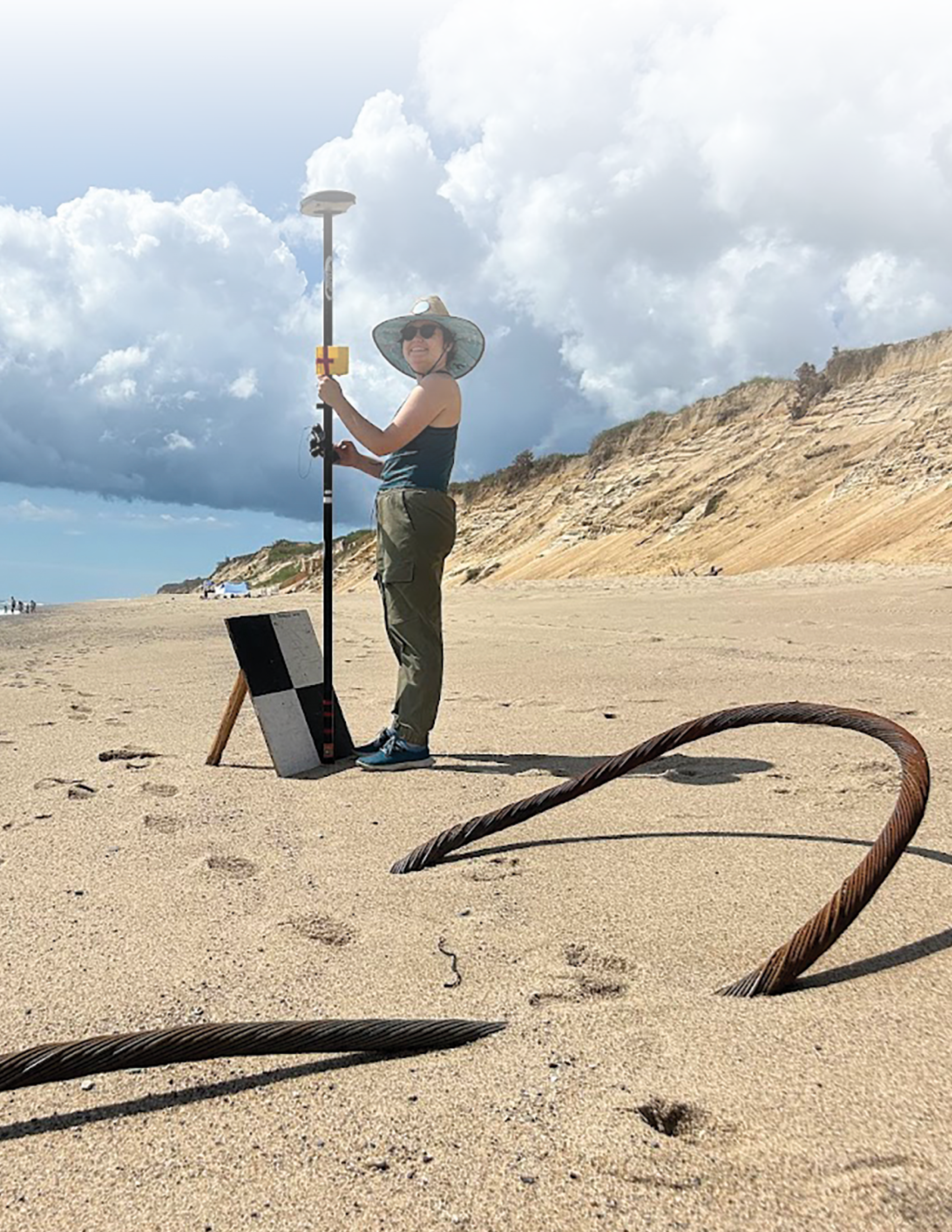
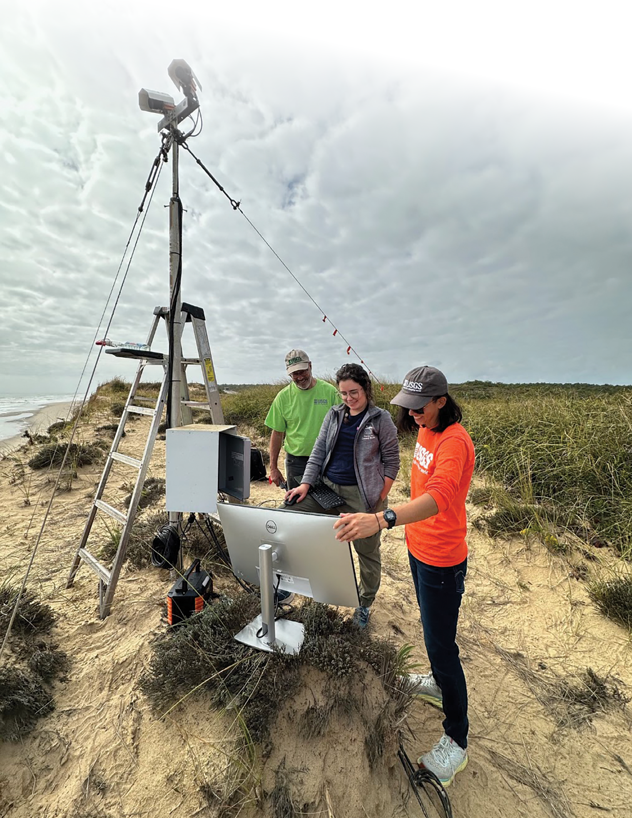
U.S. Geological Survey contractor Athina Lange using a black and white extrinsic calibration target at Marconi Beach, Cape Cod National Seashore, Massachusetts, on June 12, 2024, to calibrate and validate the geolocation. The target is one of many used to put the CoastCam—a camera used to monitor coastal conditions in near realtime—into real-world coordinates.
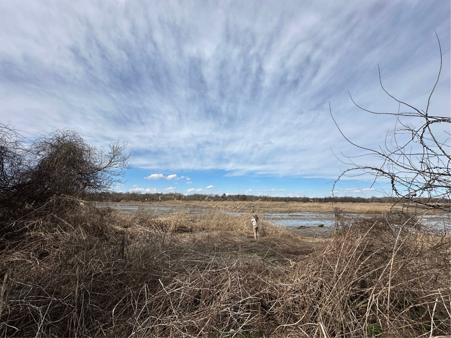
U.S. Geological Survey geographer Jen Cramer collecting a survey point at the John Heinz National Wildlife Refuge in March 2024, as part of an effort to help validate uncrewed aircraft system (UAS) light detection and ranging (lidar) products.
Coastal and Shelf Geology
Big, impactful events like hurricanes, as well as steady processes like sea-level rise, can cause our coastlines to change. These changes can threaten people’s lives and livelihoods, damage homes and roads, and alter important habitats.
The Coastal and Shelf Geology group is at the forefront of understanding coastal change through robust mapping and computer modeling. By using modern technology such as high-resolution sea-floor mapping and uncrewed aircraft systems (drones), we can characterize the coastal landscape above and below the water. These detailed maps are used to improve forecasts of coastal change and identify areas vulnerable to storms, erosion, and sea-level rise. This work helps coastal managers prepare for these challenges and protect our vital natural resources.
Future Landscape Adaptation and Coastal Change
The effects of climate change on our coastal landscapes will be profound—causing significant environmental and socioeconomic consequences in our communities. Decision makers rely on coastal change predictions to successfully plan for hazards driven by sea-level rise, storms, and other facets of climate change.
The Future Landscape Adaptation and Coastal Change (FLACC) project provides critical information to coastal planners by integrating their understanding of individual hazards with probabilistic assessments. The project’s predictive modeling also accounts for the interplay between coastal processes and landscape response. These predictions help coastal planners tackle habitat and species management; preserve natural, cultural, and archaeological resources; develop sound infrastructure and design strategies; and bolster community resilience.
https://www.usgs.gov/centers/whcmsc/science/future-landscape-adaptation-and-coastal-change-flacc
Highlights of 2024
Reimbursable Funding for Coastal Change Products Secured
The FLACC project team secured reimbursable funding from the U.S. Department of Defense to expand the Coastal Change Likelihood and Coastal Response Likelihood product suite to the southeastern Atlantic coast. The Coastal Change Likelihood assessment determines the future likelihood of coastal change. The Coastal Response Likelihood assessment predicts coastal response to sea-level rise under a range of future scenarios. Additional reimbursable funding was secured through the USGS Northeast Climate Adaptation Science Center to explore the usability of landscape change products with coastal managers.
Coastal Landscape Change Workshop Held
The FLACC project team hosted a second workshop on ecosystem processes in forecasts of coastal landscape change, in Fort Collins, Colorado. The workshop is part of a multidisciplinary project, funded by the USGS John Wesley Powell Center for Analysis and Synthesis, to synthesize what is known about coastal physical and ecological change. This project can help identify monitoring opportunities based on early warning signs of impending change, as well as inform and improve the ability to anticipate future change on coastal barrier islands.
Served as Subject Matter Experts
FLACC project staff served in authorship roles on the “Coastal Effects” chapter in the Fifth National Climate Assessment—the U.S. Government’s report on climate change impacts, risks, and responses. It is a congressionally mandated interagency effort that provides the scientific foundation to support informed decision making across the United States. They also served as subject matter experts and content developers for a new interagency U.S. Sea Level Change website that provides federally supported data visualizations coupled with explanations and science education to help communities prepare for challenges that will affect coastal environments. Landscape changes in response to future sea-level rise were particularly highlighted. Additionally, one project team member represented the USGS on the National Aeronautics and Space Administration (NASA) Sea Level Change Team practitioner board. The board consults with the NASA Sea Level Change Team to discuss best practices for scientists to produce guidance and for boundary organizations to take this guidance and turn it into actionable information.
https://earth.gov/sealevel/us/
https://www.ncics.org/pub/jared/PNATTMBTC/NOT_NCA5/NCA5_Ch9_Coasts.pdf
Coastal Change Hazards Technical Capabilities and Applications
Multiple research projects rely on core technical capabilities to further scientific progress. The Coastal Change Hazards Technical Capabilities and Applications (TCA) project leverages technical talent across the three USGS Coastal and Marine Hazards and Resources Program centers to help researchers advance coastal change hazards science that is in demand and applicable at the national scale. The project maintains high-visibility, public-facing platforms for delivering information, while keeping the underlying scientific assessments relevant and current. The TCA group advises other projects on how to expand existing assessments and incorporate new assessments into the USGS coastal change hazards science portfolio. This guidance helps ensure that additions fill science gaps and contribute to a cohesive national story.
Highlights of 2024
DSAS Developed Into Standalone Application
The Digital Shoreline Analysis System (DSAS) version 6.0 was developed as a standalone application that can be used alongside any geographic information system. Now DSAS can meet global demand without access or use limitations. Like previous versions, it enables users to calculate rate-of-change statistics from multiple historical shoreline positions.
https://www.usgs.gov/centers/whcmsc/news/digital-shoreline-analysis-system-dsas-update
National Shoreline Change Data Catalog Created and Other Shoreline Products Updated
The TCA project team created the National Shoreline Change Data Catalog—a single location for accessing USGS national shoreline datasets and data reports. The catalog was added to the WHCMSC’s ScienceBase community page and is organized by State to make shoreline data easier to find. New shoreline data are added after publication. These data can help coastal managers identify areas of the coast most likely to experience significant change over time. The project team also continued to expand historical shoreline change products to include Long Island Sound and started to update light detection and ranging (lidar)-derived shorelines for Alabama, Mississippi, Louisiana, and Texas.
https://www.sciencebase.gov/catalog/item/5b97f1b4e4b0702d0e842183
Understanding Positional Accuracy of Satellite-Derived Shorelines
The team is focused on understanding the positional accuracy of satellite-extracted shoreline positions in comparison to traditionally collected shoreline positions (from maps or lidar elevation data). Specific activities include (1) extracting shoreline positions from satellite data and examining how different processing factors impact shoreline location, (2) assessing the positional accuracy of satellite-derived shoreline positions by comparing them to each other and to traditionally obtained shoreline positions, and (3) comparing shoreline change rates derived from satellite data with rates obtained from traditional shoreline position sources.
Sharing the Science: Publications and Presentations
Two data reports and three data releases from the TCA project were published. One of the data reports and one of the data releases are focused on national shoreline change from the 1800s to 2010s for the coast of California. The other data report covers national shoreline change from the early 1900s to the 2010s for Puerto Rico. The remaining releases contain data on beach foreshore slope for the West and East Coasts of the United States. The project team also gave two poster presentations at the Ocean Sciences meeting in New Orleans, Louisiana, on shoreline forecasting and satellite shorelines.
Aerial Imaging and Mapping
The Aerial Imaging and Mapping Group (AIMG) plays a key role in enhancing our understanding of coastal ecosystems through their innovative fieldwork and mapping techniques. By using uncrewed aircraft system (UAS) technology, the group can quickly and affordably map coastal areas and assess both short- and long-term changes. The various data they collect are useful for many different scientific studies. High-resolution imagery and elevation maps can be used to monitor landscape change, assess hurricane damage, respond to natural disasters, and provide situational awareness for emergencies.
The AIMG also collaborates with other UAS operators within the U.S. Department of the Interior to explore new technologies and methods for data collection. This work supports the Remote Sensing Coastal Change project, the Coastal Change Hazards programmatic focus, the national UAS project office, and other Bureau-wide remote-sensing projects. Additionally, the AIMG leads the small uncrewed aircraft system (sUAS) capability team for the USGS Northeast Region.
https://www.usgs.gov/centers/whcmsc/science/aerial-imaging-and-mapping
Highlights of 2024
Mapping Conducted at Various Locations
The AIMG created high-resolution mapping products for various locations to detect changes in coastal ecosystems, provide critical data for monitoring, and increase understanding of processes shaping these ecosystems. Mapped locations include the Lower Darby Creek Area Superfund Site in Darby Creek, Pennsylvania; Marsh Island in New Bedford, Massachusetts; Town Neck Beach in Sandwich, Mass.; Sesuit Creek Marshes in Dennis, Mass.; and Vermilion River in Trout Creek, Montana. Mapping at the Lower Darby Creek Area Superfund Site is part of an ongoing project led by the U.S. Environmental Protection Agency to remediate contaminated areas and monitor changes to the site.
https://www.usgs.gov/centers/whcmsc/news/monitoring-change-lower-darby-creek-area-superfund-site
Sea-Floor Mapping
The Sea Floor Mapping Group (SFMG) is crucial in supporting various projects at our science center, as well as at the other two Coastal and Marine Science Centers in St. Petersburg, Florida, and Santa Cruz, California. Their team, made up of geologists, engineers, technicians, and geographers, is dedicated to collecting detailed information about the sea floor, such as its shape, sediment composition, and underlying geologic structure. Sea-floor video, photographs, sediment cores, and samples are collected to ensure data accuracy.
This wealth of information provides the foundation needed to study sediment and contamination movement, landslide and tsunami hazards, gas hydrates, methane and carbon flux, sea-floor habitat quality, coastal change, and more. The knowledge and maps produced by these studies help managers, policymakers, and other stakeholders make informed decisions about our coastal and ocean resources.
https://www.usgs.gov/centers/whcmsc/science/sea-floor-mapping-group
Highlights of 2024
Development of SEABOSS Version 2.0 Completed
The SFMG finished the redesign of the Seabed Observation and Sampling System (SEABOSS), version 2.0. Optical and recording systems were upgraded to increase image resolution and operational efficiency in the field. Python applications were developed for real-time record keeping during survey operations.
More Than 140 Terabytes of Data Added to Cloud Storage
The SFMG, in collaboration with the Information Technology group, added more than 140 terabytes of USGS data collected during center research programs over several decades to cloud storage platforms. The cloud storage capabilities provided a stable, low-cost, off-site data storage and backup solution for the center. The data can be retrieved at any time, providing backup for decades of USGS geophysical and geologic data.
Multiple Coastal and Marine Research Projects Supported
The SFMG supported a range of coastal and marine research projects through data acquisition, processing, and interpretation. This included near-real-time processing and quality control of multichannel seismic, subbottom, and bathymetric data offshore Puerto Rico; mapping and sample collection offshore the Mississippi River Delta front; investigating subsurface stratigraphy and evidence of faulting and slope failure in Prince William Sound, Alaska; and much more. The group also assisted WHOI, the U.S. Navy’s Office of Naval Research, and industry cooperators with field acceptance tests of multibeam echosounder and subbottom system upgrades on the research vessel Neil Armstrong in the mid-Atlantic Ocean. Staff provided near-real-time processing and quality control of data from the new systems and reported insights and recommendations to the working group after the cruise. Guidance on best practices of data acquisition and processing with the new instruments was given during subsequent cruises to the New England Seamounts. Additionally, the SFMG supported the center’s dive program by recovering underwater equipment that measures water currents for the USGS New England Water Science Center and by participating in the deployment, recovery, and assessment of the rapid-response ocean-bottom seismograph fleet when the seismographs were tested offshore Cape Cod, Massachusetts.
The Woods Hole Coastal and Marine Science Center’s Sea Floor Mapping Group conducted mapping and sampling efforts in the Atlantic Ocean and the Gulf of America. Seismographs were deployed in and around Skilak Lake, Alaska.
Geologic Mapping: Links to Coastal Vulnerability and Hazards
The goal of the geologic mapping project is to uncover the resources and potential coastal hazards of a region by exploring its geological features. By mapping these areas and analyzing the data, the project team creates baseline datasets and informative maps that serve as a foundation for scientific research. These products are invaluable to planners and decision makers responsible for managing resources and mitigating hazards along the coast.
Highlights of 2024
Wind Energy Areas Surveyed in the Gulf of Maine
The USGS began a new partnership with the Bureau of Ocean Energy Management (BOEM) to characterize the benthic habitat in the Gulf of Maine wind energy areas, identify mapping data gaps, and develop an advanced deep shelf sampler. As a first step, scientists from the center collected multibeam echosounder bathymetry and backscatter data to survey these wind energy areas. Fully processed and quality-controlled bathymetric and backscatter maps were submitted to the National Oceanic and Atmospheric Administration (NOAA) and BOEM within a week of completing the survey.
Continued Study to Identify Geohazards Associated With Offshore Wind Energy
Scientists from the center continued a study with the Bureau of Safety and Environmental Enforcement to identify geohazards associated with offshore wind lease areas and cable corridors.
TESNAR Webinar Series Presentation
Scientists from the center presented during the Technical Training Education in Support of Native American Relations (TESNAR) webinar series: “Mapping and Geospatial Techniques and Tools Applied to Natural Resource, Cultural Preservation, and Emergency Management Programs.” They discussed paleolandscapes and geographic information system (GIS) applications. This series was hosted by the 2024 Tribal Nation sponsor, the Wampanoag Tribe of Gay Head (Aquinnah). Invited attendees may be Tribal members, Tribal government staff, or Tribal students of any skill level with interest in learning geospatial analysis and data visualization techniques.
Coastal Change Hazards and Sea-Floor Mapping Project: Massachusetts Integrated Coastal Studies
Managers and scientists often lack the high-resolution data needed to improve estimates of sediment abundance and movement, shoreline change, and sea-floor characteristics that influence coastal vulnerability. The USGS, in partnership with the State of Massachusetts, initiated the Massachusetts Integrated Coastal Studies project to address these needs and fill critical data gaps in Cape Cod Bay, Massachusetts. In this initiative, our scientists produce high-resolution sea-floor maps, assess shoreline change and create new methods of predicting change, and use the USGS Coupled Ocean-Atmosphere-Wave-Sediment Transport (COAWST) modeling system to study how storms move sediment in the bay and along the shore. A more complete understanding of the processes contributing to coastal change in Cape Cod Bay can help coastal managers better protect our coastal communities and vital infrastructure.
https://www.usgs.gov/centers/whcmsc/science/massachusetts-integrated-coastal-studies-mics
Highlights of 2024
Multichannel Seismic Survey in Nantucket Sound
A multichannel seismic survey was conducted within Nantucket Sound, offshore Massachusetts, to characterize the subsurface of the sea floor. This supplemented 2023 field efforts in which sea-floor video, high-resolution images, and sediment samples were collected. These data can be used to help locate potential sand sources, delineate habitat, improve navigation charts, aid in maritime safety, and determine potential placement of renewable energy infrastructure.
Marine Geohazards and Resources
Geologic activity in the ocean can cause dangerous events, such as earthquakes, volcanic eruptions, and submarine landslides, that threaten lives, critical infrastructure, and valuable resources both at sea and on land. Our scientists study the recent history of marine geohazards and evaluate the future potential and probable impacts of these events on a regional basis. We conduct field-based surveys to better understand the processes that cause the hazard and develop reliable deterministic and probabilistic hazard estimates. This information helps decision makers reduce risks to people, the environment, and natural resources.
The United States is increasingly dependent on resources for energy, raw materials for construction, and minerals vital to communication and information technologies. Offshore areas hold enormous potential for energy and mineral resources, including oil, gas, and gas hydrates and deep-sea minerals critical to industry and technological applications. Scientists studying marine resources at the center are part of national and international collaborative efforts to determine where the United States has jurisdiction to manage marine resources and to understand the characterization and distribution of potentially valuable resources. Our scientists map the sea floor and collect and analyze samples to investigate resource potential and learn how and where critical minerals form. Their research and science-based products provide decision makers with information needed to understand offshore resource potential and develop resources safely and sustainably.
Gas Hydrates Project
Gas hydrates are crystalline solids made of water and gas. They look and act much like ice but contain huge amounts of methane—a potent greenhouse gas. These structures form in sediment beneath the sea floor and in frozen regions when the right pressure and temperature conditions come together.
In the USGS Gas Hydrates Project, our dedicated scientists study how and where hydrates form, their energy resource potential, and the hazards they may pose to the environment, infrastructure, and coastal communities. The project team investigates the environmental impact of gas hydrates breaking down and releasing methane into sediments, the ocean, or the atmosphere. Additionally, the team studies gas hydrate influence on sea-floor instability, which can lead to landslides that can trigger tsunamis or damage ocean infrastructure, such as cables and pipelines.
The project team consists of experts from four USGS offices across the country: the Central Energy Resources Science Center in Denver, Colorado; the Earthquake Science Center in Moffett Field, California; the Pacific Coastal and Marine Science Center in Santa Cruz, California; and our center in Woods Hole, Massachusetts. With support from the U.S. Department of Energy, this team has led gas hydrate research for over 30 years, collaborating with other Federal agencies to shape national research priorities. Together, they are uncovering the mysteries of gas hydrates and gaining a better understanding of their potential benefits and hazards.
https://www.usgs.gov/centers/whcmsc/science/us-geological-survey-gas-hydrates-project
Highlights of 2024
Major Contributions to Drilling Expedition Preliminary Report Made
Gas Hydrates Project scientists made major contributions to a preliminary report on a Department of Energy-sponsored hydrate-drilling expedition in the deepwater Gulf of America in 2023. The expedition focused on characterizing high-saturation methane hydrate deposits. USGS scientists led key parts of the drilling expedition and are managing critical aspects of postexpedition research. Their contributions focus on the sedimentary history of the hydrate reservoir, the evolution of gases in the reservoir, and sediment properties that could be important to long-term sea-floor stability and potential gas production from the hydrates.
Long-Term Production Test to Extract Methane From Gas Hydrates Completed
The world’s first long-term production test to extract methane from gas hydrates was completed at the Alaska hydrate well in the thick, continuous permafrost near Prudhoe Bay, Alaska. Gas Hydrates Project scientists formulated the science plan for the specialized coring that preceded the production test, comprised most of the onsite scientific staff in late 2022, and played critical roles throughout the production test in 2023–24. During the test, gas and fluid samples were collected according to protocols developed by the USGS, with samples periodically rush-shipped back to WHCMSC laboratories for further analysis.
Sea-Floor Methane Seeps Inventory for U.S. Atlantic Margin Expanded
The Gas Hydrates Project team led a major study that integrated a decade of data on the U.S. Atlantic margin cold seep—a crack in the ocean floor from offshore South Carolina to southeast of Cape Cod where gas escapes into the surrounding seawater. The research and associated data release expand the number of known sea-floor methane seeps on this margin and provide insight into potential locations for exploring new chemosynthetic communities (ecosystems where organisms use chemical energy from inorganic compounds like methane to produce food). The study provides explanations for the evolution of different classes of seeps and for seep distribution along the margin. The research also confirms that most seeps are probably not directly related to the breakdown of gas hydrate beneath the upper continental slope.
Law of the Sea—Outer Limits of the U.S. Continental Margins
The USGS Law of the Sea project is part of a Federal interagency effort to identify the outer limits of the U.S. extended continental shelf—the area beyond 200 nautical miles from shore where the United States can manage resources found on and below the sea floor. The U.S. Department of State leads the interagency effort and manages the project’s diplomatic and legal aspects, while the USGS and NOAA collect, process, and interpret the data needed to determine the U.S. outer limits. The USGS specifically leads efforts concerning seismic and geologic data. This has included leading or participating in 10 major research expeditions, during which more than 28,000 kilometers of sea-floor subbottom data were collected. Data collection for the interagency project began in 2003. It is the largest offshore mapping effort ever conducted by the United States.
https://www.usgs.gov/science/usgs-law-sea
Highlights of 2024
U.S. ECS Outer Limit Coordinates Announced
The U.S. ECS outer limits were publicly announced in December 2023 for the first time. This area is approximately 1 million square kilometers—about twice the size of California—spread across seven regions: the Arctic, Atlantic (east coast), Bering Sea, Pacific (west coast), Mariana Islands, and two regions in the Gulf of America. This is the culmination of over 20 years of work. The U.S. Department of State, USGS, and NOAA assembled a media package, fact sheet, and a project web page on the U.S. Department of State website.
Marine Geohazards Sources and Probability
The goal of the Marine Geohazards Sources and Probability project is to increase our understanding of various marine hazards, such as earthquakes, landslides, tsunamis, and underwater volcanoes. By learning more about the underlying processes that drive these hazards, the project team can estimate which hazards may occur in specific areas and assess their likelihood. The models and hazard assessments created by the team are used by engineers and policymakers to keep our communities safe and prepared for potential marine hazards.
https://www.usgs.gov/science/science-explorer/ocean/marine-geohazards
Highlights of 2024
Rapid-Response Ocean-Bottom Seismograph Fleet Developed and Tested
The USGS partnered with the WHOI Ocean Bottom Seismic Instrument Center to maintain and operate a fleet of small ocean-bottom seismographs dedicated to rapid-response efforts. This new fleet was successfully tested offshore Cape Cod, Massachusetts, in April 2024. A response plan for providing on-call staff and equipment for rapid deployments in response to major marine geohazards is being developed. The new fleet represents an advancement in rapid-response capabilities for marine geohazards.
https://www.usgs.gov/news/featured-story/rapid-response-seafloor-seismology
Seismographs Deployed at Skilak Lake, Alaska
A team of USGS scientists, in collaboration with partners from the WHOI Ocean Bottom Seismic Instrument Center, deployed two seismographs on the bottom of Skilak Lake in Alaska and eight seismographs on land around the lake to create a record of past earthquakes in the area. Each instrument will collect data there for about 1 year. These data can improve seismic hazard models, leading to more accurate risk assessments and better overall preparedness.
https://www.usgs.gov/centers/whcmsc/news/unveiling-earthquake-history
Puerto Rico Sea Floor Mapped to Learn About Earthquake Activity
A three-part sea-floor mapping effort was conducted offshore Puerto Rico to learn more about earthquake activity in the area. The research team first mapped the subsurface fault system associated with recent earthquake activity around Guayanilla Canyon on the island’s southwestern margin. In the next two parts, USGS collaborated with WHOI and the University of Texas at Austin to map the geometry of the transform boundary between the North American and Caribbean plates beneath the Puerto Rico Trench. Ocean-bottom seismographs were also deployed in the area. The data collected can help researchers evaluate the potential for earthquakes in the region.
Continued Characterization of the Sea Floor Offshore the Mississippi River Delta Front
Scientists continued to characterize the sea floor offshore of the Mississippi River Delta front by conducting a multibeam echosounder mapping effort. Sediment cores were also collected at the sea floor with a multicorer developed at the center. These data and samples, in conjunction with those collected in 2017, 2022, and 2023, can be used to guide assessments of current and future hazards in the region.
Coastal and Estuarine Dynamics
Coastal systems are constantly changing, shaped by the movement of sediment driven by waves, wind, currents, tides, storms, and rising sea levels. Understanding how these forces affect our coastlines is crucial for increasing coastal resilience and reducing vulnerabilities to hazards, including infrastructure loss, declines in tourism, and effects on important habitats.
The Coastal and Estuarine Dynamics group uses advanced oceanographic tools to observe and measure how sediment moves in coastal waters. These observations are key to creating computer models that help us grasp the past, present, and future of these dynamic ecosystems. Our models vary in scale, from studying local estuaries and barrier islands to analyzing the entire U.S. Atlantic coast.
By combining real-world observations with sophisticated modeling, we enhance hazard and resource assessments—equipping coastal managers with vital information to make informed decisions. This work helps protect people who live on the coast, communities that depend on the coast for their livelihoods and recreational enjoyment, and the health of valuable coastal ecosystems.
Cross-Shore and Inlets Processes
The Cross-Shore and Inlets Processes project is focused on increasing our understanding of the coast, from estuaries to the continental shelf, and our ability to predict its evolving form and shape. A key part of this effort is the development of the COAWST modeling system—a tool that simulates storms realistically by allowing different earth-system models to interact with one another.
This project is a vital component of the National Oceanographic Partnership Program (NOPP) Hurricane Coastal Impacts initiative. NOPP brings together Federal agencies, universities, and industry experts to push the boundaries of ocean science research and education. The Hurricane Coastal Impacts project aims to improve forecasts of storm impacts, helping communities prepare for potential damage caused by coastal flooding, waves, and strong winds. The Cross-Shore and Inlets project team is focused on the modeling tasks within this NOPP project. Using the COAWST model, they create 5-day forecasts for approaching hurricanes. They use real-world observations made during the storm to validate their forecast and further improve the COAWST model.
Planners and emergency managers need reliable forecasts to protect coastal communities. Though natural hazards are unavoidable, their impacts can be reduced with proper preparedness.
https://www.usgs.gov/centers/whcmsc/science/cross-shore-and-inlets-csi-processes
Highlights of 2024
Forecasts and Hindcasts of Three Hurricanes Produced
During the 2024 hurricane season, the project team forecast the impacts of Hurricanes Francine (September), Helene (September), and Milton (October) as each hurricane approached the coast. The forecasts were available in the Coastal Change Hazards Portal, showing predicted maximum wave heights and water level (tide and storm surge) for the next 5 days along the Gulf of America and eastern Atlantic coastlines. They also conducted hindcast simulations post-storm to evaluate the accuracy of their forecasts and improve model performance. The team is working on comparing the model results against rapid-response real-time measurements of wave conditions.
Total Water Level and Coastal Change
The Next-Generation Total Water Level and Coastal Change (TWL&CC) Forecast project is a collaboration between the three USGS Coastal and Marine Science Centers in Santa Cruz, California; St. Petersburg, Florida; and Woods Hole, Massachusetts. At the heart of the project is the TWL&CC Forecast Viewer, a user-friendly online platform that offers multiday forecasts based on simulations of tides, storm surge, wave conditions, and coastline features. This tool covers nearly 3,000 miles (about 4,700 kilometers) of sandy coastline along the Atlantic and Gulf coasts, with ongoing expansion to the Pacific coast and nonsandy environments. It is the only national-scale, real-time model for coastal change.
The project team is focused on several key goals, including assessing how well the forecasts perform by comparing them to real-world observations, improving accuracy by integrating new data and research, and developing spatially varied and ensemble versions of the model that include certainty estimates. By continually improving forecast accuracy and expanding the geographic and environmental coverage, coastal managers and planners can better prepare for storms and other coastal change hazards, ultimately helping to safeguard our communities.
Highlights of 2024
Outer Cape CoastCams Maintained and Areas Mapped
The Coastal and Estuarine Dynamics group continued to maintain two CoastCams on outer Cape Cod, Massachusetts. The cameras are used to compare wave runup measurements (the maximum onshore elevation reached by waves) with TWL&CC forecasts. The group also generated maps of the areas in front of the cameras using aerial imagery from a helium-filled kite and echosounder data from an autonomous, surf-capable boat. Later in the year, uncrewed aerial systems were used to map substantial erosion at Marconi Beach in Wellfleet, Massachusetts.
Influence of Sandbars on Wave Runup Assessed
The project group started assessing the influence of sandbars on wave runup using realistic models that represent complex, real-world processes, and idealized models that offer a simplified representation of those complex processes, at Marconi Beach in Wellfleet, Massachusetts, and on the Outer Banks of North Carolina. The model results can be used to modify the runup formulations used in the TWL&CC forecasts.
Remote Sensing Coastal Change
The Remote Sensing Coastal Change project is a multicenter collaboration to improve how we use remote-sensing techniques to address coastal change challenges. At the Woods Hole center, project scientists are focused on rapidly responding to coastal events like hurricanes and advancing how imagery is processed by use of structure-from-motion photogrammetry—a technique used to create high-resolution digital models of surface elevation. Project scientists also develop USGS Cloud Hosting Solutions that make data more accessible and explore how machine learning can streamline workflows.
By bringing together advanced technology and innovative strategies, the project team aims to better understand our ever-changing coastal landscape, ensuring coastal managers have the information and tools they need to protect coastal communities and ecosystems.
https://www.usgs.gov/index.php/centers/pcmsc/science/remote-sensing-coastal-change
Highlights of 2024
Hurricane Data Collected and Disseminated
Using aerial images collected before and after Hurricane Ian (September 2022), the project team created detailed maps (orthomosaics) and digital elevation models of the affected portions of the Florida coast. The data were disseminated as an emergency release product in October 2023. Hurricane Ian recovery continues to be mapped by the project team. The team also collected data before and after Hurricane Helene (September 2024)—a devastating Category 4 storm. Before-and-after comparisons are critical for scientists to measure how the coast has changed and to evaluate the accuracy of USGS forecasts.
Estuarine Processes, Hazards, and Ecosystems
Estuaries are dynamic environments where complex interactions take place between the atmosphere, ocean, watershed, ecosystems, and human infrastructure. They serve as valuable ecological habitat and provide numerous benefits to our society. Unfortunately, estuaries face challenges from natural events and processes like storms and rising sea levels, as well as from human activities.
The Estuarine Processes, Hazards, and Ecosystems project team collects data on how these events, processes, and activities affect estuaries. They use this information to develop models that help us better understand the past, present, and future states of these ecosystems. The team is highly collaborative, working closing with academic institutions and Federal and State agencies to ensure their research and science-based products meet the needs of land and resource managers across the Nation.
https://www.usgs.gov/centers/whcmsc/science/estuarine-processes-hazards-and-ecosystems
Highlights of 2024
Collaboration With Key Partners Continued
The project team continued collaboration with several organizations, including the Wells National Estuarine Research Reserve (NERR) and the U.S. Fish and Wildlife Service (USFWS). The Wells NERR and USGS hosted two workshops to demonstrate how USGS geospatial products related to marsh health could be used to support statewide conservation and management decisions in Maine. The USGS and USFWS combined unvegetated-to-vegetated marsh ratio datasets with national wildlife refuge boundaries and surface elevation data to coproduce an interactive map of selected southeastern national wildlife refuges. They continue to study how southeastern wetlands are responding to sea-level rise.
https://www.usgs.gov/centers/whcmsc/news/aligning-salt-marsh-science-management-needs
Novel Method for Assessing Inland Migration of Salt Marshes Developed
A novel method to calculate and map salt marsh migration potential was developed. The product improves understanding of marsh lifespan under sea-level-rise and climate change scenarios by integrating inland migration potential. The project team presented an application to Chesapeake Bay at the USGS Chesapeake Bay Workshop.
Wetland Geonarratives Updated
The project team updated their two wetland geonarratives—"U.S. Coastal Wetland Synthesis Applications” and “U.S. Coastal Wetland Geospatial Collection”—to new interfaces. These two applications are the gateways for accessing their methods and data products.
https://geonarrative.usgs.gov/uscoastalwetlandsynthesis/
https://geonarrative.usgs.gov/us_coastal_wetland_collection/
Paper About Using Geospatial Data to Guide Marsh Restoration Highlighted
A USGS paper, titled “Using Geospatial Analysis to Guide Marsh Restoration in Chesapeake Bay and Beyond,” was highlighted in Coastal & Estuarine Science News—a newsletter that highlights the latest research in the journal Estuaries and Coasts that is relevant to environmental managers.
https://cerf.memberclicks.net/cesn-2023-issue-6
U.S. Geological Survey researchers Chris Sherwood, Athina Lange, and Jin-Si Over check images of Marconi Beach in Wellfleet, Massachusetts, after moving the CoastCam located on the bluff. The bluff eroded more than 6 meters (nearly 20 feet) in the spring, putting the camera at risk—necessitating the camera move.
Environmental Geoscience
Our coasts are home to diverse environments that provide essential habitat for a wide variety of plants and animals. From lush wetlands to bustling estuaries and dynamic coastal margins, these ecosystems deliver critical benefits and services to our communities.
Research by the Environmental Geosciences group focuses on understanding how these ecosystems function and what causes them to change. Through fieldwork and sample analysis, we gather insights that help model and map the effects of rising sea levels, climate change, and expanding coastal development on these critical ecosystems. This work provides important data and products to Federal, State, and local agencies responsible for managing coastal ecosystems.
Sea-Level Rise and Carbon Cycle Processes in Managed Coastal Wetlands
Coastal wetlands that have been damaged or destroyed can lose their ability to capture carbon dioxide, and the large quantities of carbon stored there can be released into the atmosphere—contributing to climate change. Improved management of salt marshes and mangroves, leading to enhanced conservation and restoration, is therefore a crucial climate change mitigation strategy.
Scientists in the Sea-Level Rise and Carbon Cycle Processes in Managed Coastal Wetlands project are dedicated to understanding the role of coastal wetlands in mitigating climate change. They study how human modifications to natural water systems affect wetland health and resilience, which are directly linked to a wetland’s ability to store carbon dioxide and protect coastal communities from other coastal hazards like storm surge. They also assess opportunities for ecosystem restoration to improve carbon capture and storage, reduce methane emissions, and increase carbon and alkalinity export to the ocean.
Persistence of these habitats in the 21st century depends on decisions made today regarding transportation infrastructure and other responses by society to sea-level-rise hazards. Federal, State, and private land management organizations can use information from this project to guide their decisions about wetland restoration and infrastructure development to ensure wetland health and resilience.
Highlights of 2024
Potential Causes and Predictors of Lateral Carbon Flux Investigated
The drivers and environmental variables that control lateral carbon movement in coastal wetlands are a knowledge gap that limits scaling and modeling efforts. To help fill this gap, USGS scientists are investigating the role of marsh inundation frequency and flooding duration as a driver and predictor of lateral carbon export, the movement of carbon from land to water. They conducted sampling and installed equipment at three New England marsh sites with different elevations to capture tidal variation and sporadic events with high-resolution, time-series measurements of surface water. They also measured carbon exchange between the marsh and atmosphere to determine how much carbon from the marsh may be available for lateral carbon export.
Ecological Changes Monitored at Herring River Restoration Site
Construction on the new Herring River bridge in Wellfleet, Massachusetts, began in January 2023 and has been making steady progress. Because of winter storms in 2024, a large portion of the Herring River Basin flooded with seawater for the first time since the original dike was built in 1909. USGS scientists monitored the rapid ecological changes caused by the seawater flooding. Their work included (1) upgrading or moving infrastructure that supports continuous measurements of carbon dioxide and methane exchange, (2) collecting samples from across the basin to determine geochemical changes, and (3) building a new eddy flux tower to capture the natural regrowth of a salt marsh. These data and observations are being used by the U.S. National Park Service Cape Cod National Seashore in adaptive management of the restoration.
Analytical Laboratories
The Core Laboratories Project is a key service for our center, providing vital support to a variety of projects studying coastal biogeochemical processes, coastal groundwater, climate-hydrate connections, and coastal and marine sediment. The project team delivers high-quality data through advanced analytical techniques and maintains laboratory equipment. Their methods are continually evolving, allowing them to provide new capabilities and meet the ever-changing needs of our projects.
At the Woods Hole center, there is a range of specialized facilities, including the Geochemistry Laboratory, the Sediment Analysis Laboratory, the Core Processing Laboratory, and the Gas Hydrates Project Physical Properties, Biogeochemistry, and Hydrate Pressure Core Analysis Laboratories. Our skilled technicians are well equipped to provide the data, equipment, and techniques needed to drive research forward.
https://www.usgs.gov/centers/whcmsc/science/analytical-facilities
Highlights of 2024
Geochemistry Laboratory: Analytical Support for Blue Carbon Projects Provided and New Instrument for Measuring Total Alkalinity Acquired
The Geochemistry Laboratory continued to provide analytical support for several projects focused on the role of coastal wetlands in carbon cycling, including monitoring the ongoing Herring River restoration in Wellfleet, Massachusetts, and measuring lateral carbon fluxes from several New England coastal wetlands. The laboratory also acquired a new alkalinity titrator with autosampler—an instrument that allows for automated measurements of total alkalinity in small-volume samples, which porewater samples often are.
Sediment Analysis Laboratory: WHCMSC Project Support Continued and New Equipment for Total Carbon Analysis Acquired
The Sediment Analysis Laboratory continued to support WHCMSC science by providing analytical resources to projects related to the marine geohazards, gas hydrates, coastal change hazards, sea-floor mapping, and coastal and estuarine dynamics. The laboratory also acquired an autosampler furnace for total carbon analysis. The autosampler furnace was completely refurbished and will be ready to make measurements in early 2025. This new capability will enhance the inorganic carbon analyses that have been used by the laboratory since 2022.
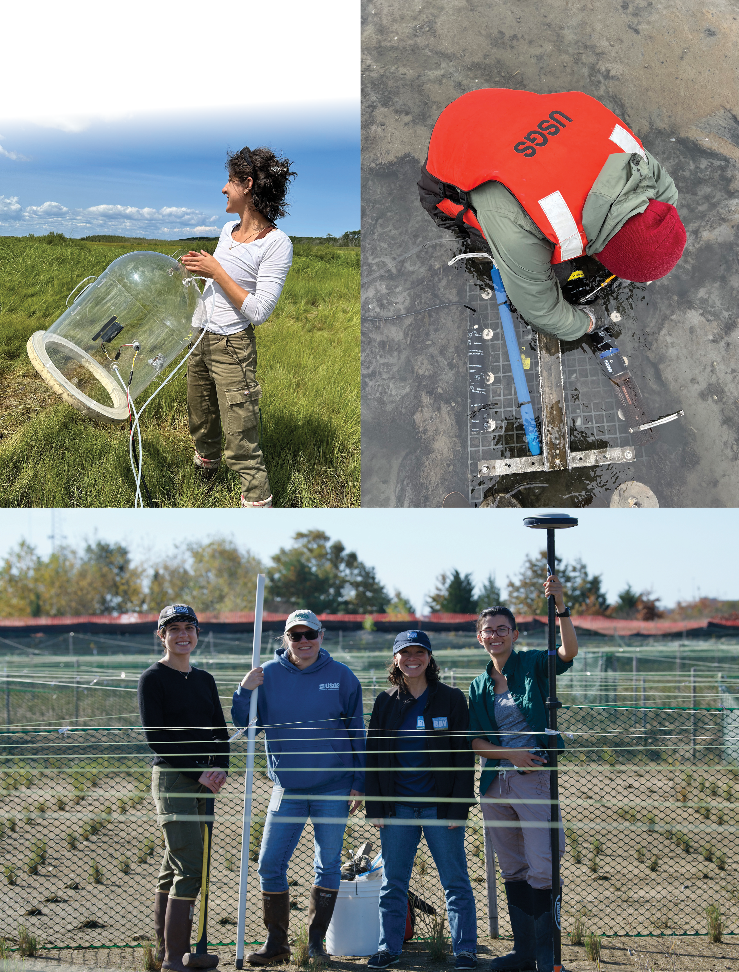
[Top left] Emily Tacke, U.S. Geological Survey (USGS) physical scientist, holds a clear chamber that is placed over salt marsh grass to measure the exchange of carbon dioxide and methane between the marsh and the atmosphere. Salt marshes have high rates of carbon dioxide uptake via photosynthesis. The plant material is incorporated into the salt marsh platform, building elevation and increasing resilience to sea-level rise. [Top right] Environmental sensors were placed on a platform within the tidal creek of a salt marsh to continuously measure water chemistry; the measurements are used to evaluate how marshes export constituents such as carbon and nutrients to the ocean. A blue pump was also placed on the platform over one tidal cycle to collect samples that could not be measured with sensors. [Bottom] Emily Tacke (USGS), Meagan Eagle (USGS), Sara Quintal (Buzzards Bay Coalition), and Jin-Si Over (USGS) install groundwater sampling wells and collect small uncrewed aircraft system data for topographic models to provide data for the marsh restoration project at a peninsula in Fairhaven, Massachusetts, known locally as “Marsh Island.”
Information Science
Our coastal and marine research is in demand by scientists, resource managers, policymakers, and the public. The Information Science group is responsible for managing and maintaining our scientific data, ensuring they are readily available in a variety of formats and online systems. The group also helps stakeholders understand their data needs and guides them to applicable USGS products.
In addition to managing our data, the Information Science group shares our research through writing articles and social media posts, crafting eye-catching infographics and deliverables, maintaining the center’s web presence, and organizing and participating in outreach activities.
Data Management and Preservation
Data management is vital for sharing and reusing data collected and published by USGS scientists, as well as reducing redundancy and costs. Well-documented data that are easily accessed can be integrated readily into new projects or datasets and allow for efficient program operations. Staff at the WHCMSC collaborate with the other Coastal and Marine Hazards and Resources Program centers to provide consistency within data management activities. The Data Library at the WHCMSC preserves and makes available a rich repository of scientific data spanning many decades of USGS research in Woods Hole. Additionally, it includes records that document project activities and provide contextual information for the data that were produced, such as field notes, cruise logs, navigation records, and photographs.
Highlights of 2024
Scientific Records Safeguarded
With the assistance of a grant from the USGS National Geological and Geophysical Data Preservation Program, the Information Science group made substantial upgrades to the Data Library to safeguard data collections against the possibility of future mold outbreaks. Improvements include installing new mold-resistant ceiling tiles and applying a fresh coat of mold-resistant paint throughout the entire library and annex spaces. New cleaning protocols have also been implemented, including using a high-efficiency particulate air (HEPA) filter vacuum to collect and remove mold-gathering dust, and a new dehumidification system was installed that helps maintain humidity levels recommended by the Northeast Document Conservation Center.
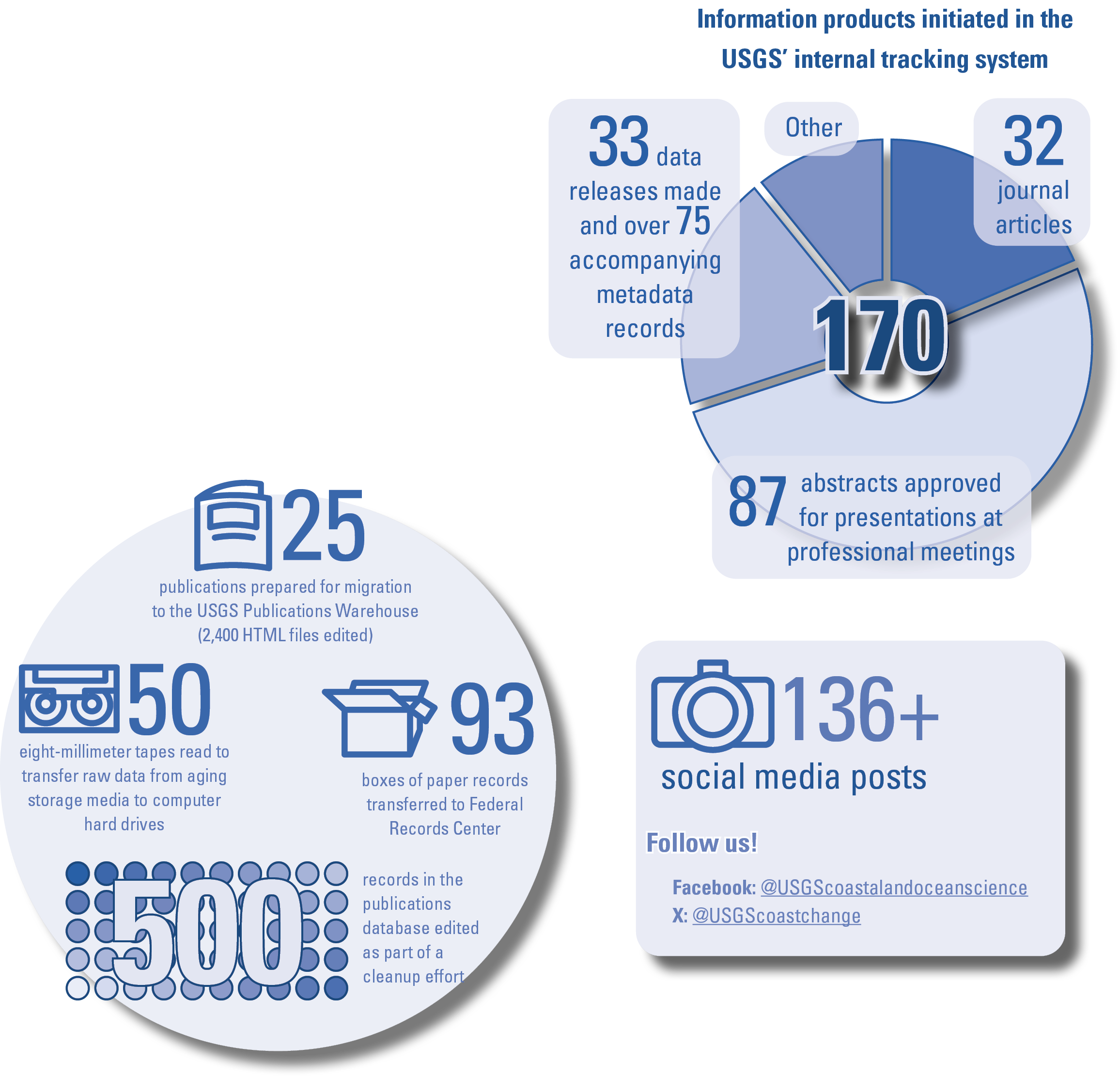
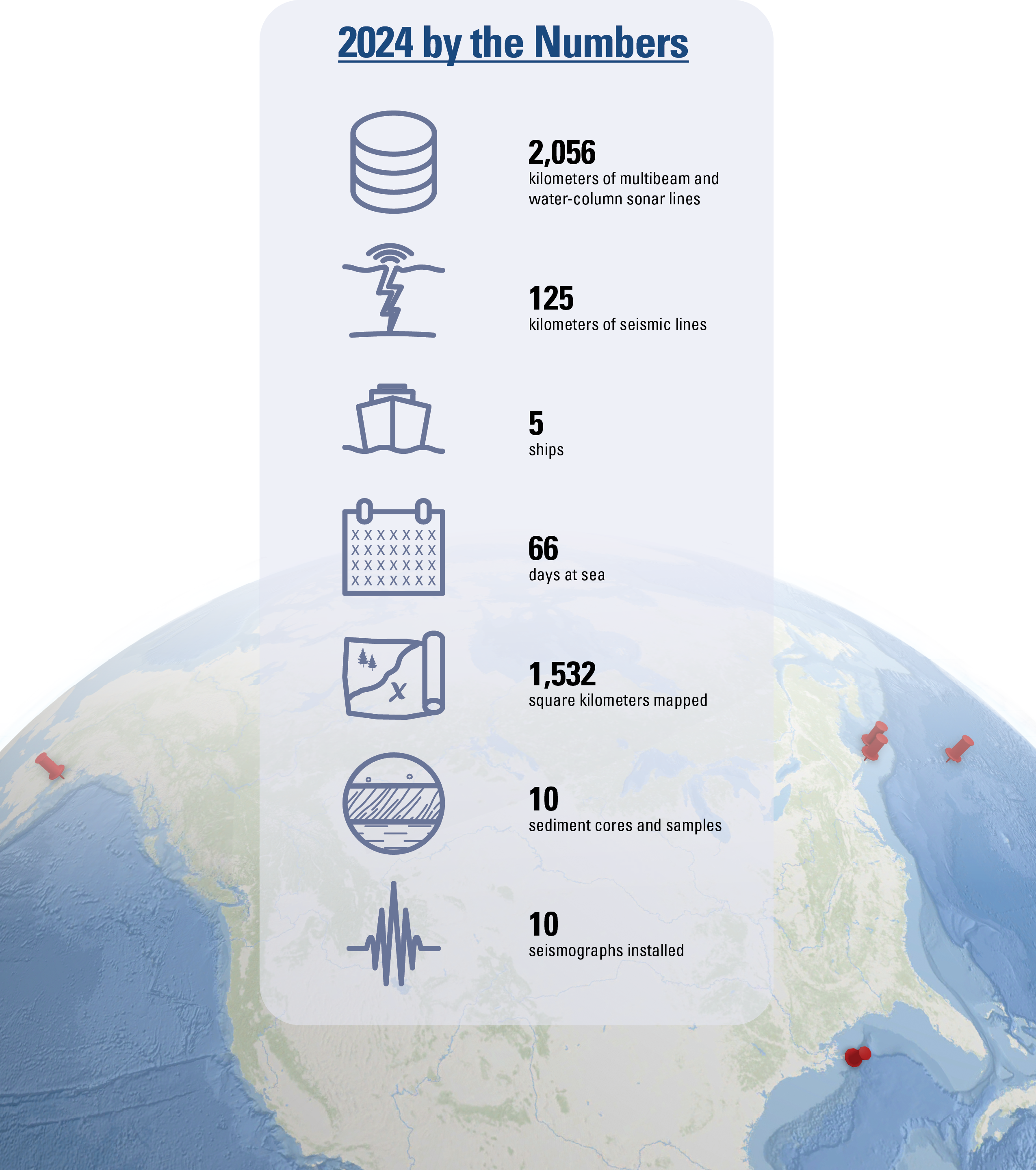
By the Numbers
Science Communications
Coastal communities and practitioners need scientific information to support decisions regarding public safety, development, economics, and environmental health. To ensure these stakeholders are aware of the science, data, and tools available through the USGS, effective communications strategies must be deployed to increase their visibility and accessibility.
At the WHCMSC, a variety of communications methods and platforms are used to share information, including social media, email marketing campaigns, media pitches, science stories and news briefs for USGS web pages and newsletters, videos, handouts for specific events, and other promotional products. Communications, stakeholder engagement, and social science experts from across the USGS also work together to further promote our science, engage with target audiences, and interpret stakeholders’ unique needs so those needs can be incorporated into science planning and products.
Highlights of 2024
Science Shared on Various Platforms
USGS coastal and marine science conducted at the center was consistently shared throughout the year. This included 20 news stories, more than 136 social media posts, 8 USGS Northeast Region highlights, 6 web pages/geonarratives, the Coastal Science Navigator Companion Guide, and infographics for events. One news story, titled “Preparing the Nation for Coastal Hazards,” and associated infographics were used for a visit to Congress on Capitol Hill in September 2024 for National Preparedness Month.
https://pubs.usgs.gov/circ/1523/cir1523.pdfhttps://www.usgs.gov/centers/whcmsc/news
Coastal and Marine Hazards and Resources Program Communications Team Lead
WHCMSC communications staff began leading the CMHRP communications team and facilitating weekly meetings. They led the group in several social media campaigns for different themes, including American Wetlands Month in May, Ocean Month in June, and hurricane season in the summer. Also, the WHCMSC communications staff is responsible for Sound Waves—a newsletter that shares coastal and marine research from across the USGS. In 2024, 6 Sound Waves issues were created and sent to more than 3,600 subscribers. The newsletter gained over 100 new subscribers from last year.
Woods Hole Science Stroll Organizer and Participant
Communications staff helped organize the annual Woods Hole Science Stroll—a free event hosted by the science organizations based in Woods Hole, Massachusetts. WHCMSC scientists volunteered to showcase USGS science and technology at our booth for the duration of the event. In 2024, the event attracted 1,700 visitors. At the USGS booth, visitors learned how drone technology is used to map short- and long-term changes in coastal environments, explored operational ocean and coastal dynamics forecasts (specifically the COAWST modeling system), looked at forminifera—tiny microfossils that live in marine environments—through a microscope, and more. The USGS also co-hosted the Woods Hole Diversity Initiative booth.
https://www.usgs.gov/centers/whcmsc/news/woods-hole-science-stroll-2024
Popular 2024 Science Stories
-
• Now Available: First CONUS-wide Coastal Wetland Collection
https://www.usgs.gov/centers/whcmsc/news/now-available-first-conus-wide-coastal-wetland-collection
-
• Habitat Preferences of Seabeach Amaranth, a Threatened Beach Dependent Plant Species
-
• Digital Shoreline Analysis System (DSAS) Update
Big changes made for version 6.0
https://www.usgs.gov/centers/whcmsc/news/digital-shoreline-analysis-system-dsas-update
-
• Preparing the Nation for Coastal Hazards
USGS Provides Emergency Responders, Resource Managers, and Communities with the Science They Need to Safeguard Lives, Infrastructure, and Resources Along the Coast
https://www.usgs.gov/programs/cmhrp/news/preparing-nation-coastal-hazards
-
• Aligning Salt Marsh Science with Management Needs
User stories show the power of participatory science
https://www.usgs.gov/centers/whcmsc/news/aligning-salt-marsh-science-management-needs
-
• Traversing the Sea for Science: How USGS Uses the Federal Fleet to Study Natural Hazards, Resources, and More
Planting dune grass on the newly built artificial berm at Town Neck Beach in Sandwich, Massachusetts. The beach has been renourished and eroded several times. The U.S. Geological Survey monitors conditions with quarterly light detection and ranging (lidar) and photogrammetric surveys with drones.
Publications
Journal Articles (19)
Bansal, S., Creed, I.F., Tangen, B.A., and others, 2023, Practical guide to measuring wetland carbon pools and fluxes: Wetlands, v. 43, article 105, 169 p., https://doi.org/10.1007/s13157-023-01722-2.
Carbotte, S.M., Boston, B., Han, S., Shuck, B., Beeson, J., Canales, J.P., Tobin, H., Miller, N., Nedimovic, M., Trèhu, A., Lee, M., Lucas, M., Jian, H., Jiang, H., Jiang, D., Moser, L., Anderson, C., Judd, D., Fernandez, J., Campbell, C., Goswami, A., and Gahlawat, R., 2024, Subducting plate structure and megathrust morphology from deep seismic imaging linked to earthquake rupture segmentation at Cascadia: Science Advances, v. 10, no. 23, 19 p., https://doi.org/10.1126/sciadv.adl3198.
Courtois, A., Bentley, S., Maloney, J., Xu, K., Chaytor, J., Georgiou, I.Y., Miner, M.D., Obelcz, J., Jafari, N.H., and Damour, M., 2024, Short-term sediment dispersal on a large retreating coastal river delta via 234Th and 7Be sediment geochronology—The Mississippi River Delta front: Water, v. 16, no. 3, article 463, 18 p., https://doi.org/10.3390/w16030463.
Figueredo, N., Bentley, S.J., Chaytor, J.D., Xu, K., Jafari, N., Georgiou, I.Y., Damour, M., Duxbury, J., Obelcz, J., and Maloney, J., 2024, Sedimentary processes and instability on the Mississippi River Delta front near the shipwreck of the SS Virginia: Water, v. 16, no. 3, article 421, 18 p., https://doi.org/10.3390/w16030421.
Flores, C.H., and ten Brink, U.S., 2024, Photogrammetry of the deep seafloor from archived unmanned submersible exploration dives: Journal of Marine Science and Engineering, v. 12, no. 8, article 1250, 19 p., https://doi.org/10.3390/jmse12081250.
Ganju, N.K., Ackerman, K.V., and Defne, Z., 2024, Using geospatial analysis to guide marsh restoration in Chesapeake Bay and beyond: Estuaries and Coasts, v. 47, p. 1–17, https://doi.org/10.1007/s12237-023-01275-x.
Ganju, N.K., Defne, Z., Schwab, C., and Moorman, M., 2024, Horizontal integrity a prerequisite for vertical stability—Comparison of elevation change and the unvegetated-vegetated marsh ratio across southeastern USA coastal wetlands: Estuaries and Coasts, v. 47, p. 2135–2145, https://doi.org/10.1007/s12237-023-01221-x.
Holmquist, J.R., Eagle, M., Molinari, R.L., Nick, S.K., Stachowicz, L.C., and Kroeger, K.D., 2023, Mapping methane reduction potential of tidal wetland restoration in the United States: Communications Earth & Environment, v. 4, article 353, 11 p., https://doi.org/10.1038/s43247-023-00988-y.
Holmquist, J.R., Klinges, D., Lonneman, M., Wolfe, J., Boyd, B., Eagle, M., Sanderman, J., Todd-Brown, K., Belshe, E.F., Brown, L.N., Chapman, S., Corstanje, R., Janousek, C., Morris, J.T., Noe, G., Rovai, A., Spivak, A., Vahsen, M., Windham-Myers, L., Kroeger, K., and Megonigal, J.P., 2023, The Coastal Carbon Library and Atlas—Open source soil data and tools supporting blue carbon research and policy: Global Change Biology, v. 30, no. 1, article e17098, 35 p., https://doi.org/10.1111/gcb.17098.
Jones, S.F., Arias-Ortiz, A., Baldocchi, D., Eagle, M., Friess, D.A., Gore, C., Noe, G., Nolte, S., Oikawa, P., Paytan, A., Raw, J.L., Roberts, B.J., Rogers, K., Schutte, C., Stagg, C.L., Thorne, K.M., Ward, E.J., Windham-Myers, L., and Yando, E.S., 2024, When and where can coastal wetland restoration increase carbon sequestration as a natural climate solution?: Cambridge Prisms: Coastal Futures, v. 2, no. e13, 16 p., https://doi.org/10.1017/cft.2024.14.
Ledeczi, A., Lucas, M., Tobin, H., Watt, J., and Miller, N., 2024, Late Quaternary surface displacements on accretionary wedge splay faults in the Cascadia subduction zone—Implications for megathrust rupture: Seismica, v. 2, no. 4, 22 p., https://doi.org/10.26443/seismica.v2i4.1158.
Lentz, E.E., Wong‐Parodi, G., Zeigler, S., Collini, R.C., Palmsten, M.L., and Passeri, D., 2024, Shaping the coast—Accounting for the human wildcard in projections of future change: Earth’s Future, v. 12, no. 10, article e2024EF004504, 8 p., https://doi.org/10.1029/2024EF004504.
Miller, K.G., Browning, J.V., Keigwin, L.D., Chaytor, J.D., Schneider, E.R., Richtmyer, M., and Schmelz, W.J., 2024, Holocene foraminifera, climate, and decelerating rise in sea level on the mud patch, southern New England continental shelf: Journal of Foraminiferal Research, v. 54, no. 2, p. 172–187, https://doi.org/10.61551/gsjfr.54.2.172.
Molino, G.D., Carr, J.A., Ganju, N.K., and Kirwan, M.L., 2023, Biophysical drivers of coastal treeline elevation: Journal of Geophysical Research: Biogeosciences, v. 128, no. 12, article e2023JG007525, 18 p., https://doi.org/10.1029/2023JG007525.
Moulton, M., Zambon, J.B., Xue, G., Warner, J.C., Bao, D., Yin, D., Defne, Z., He, R., and Hegermiller, C., 2024, Modeled coastal-ocean pathways of land-sourced contaminants in the aftermath of Hurricane Florence: Journal of Geophysical Research: Oceans, v. 129, no. 3, article e2023JC019685, https://doi.org/10.1029/2023JC019685.
Reithmaier, G.M.S., Cabral, A., Akhand, A., Bogard, M.J., Borges, A.V., Bouillon, S., Burdige, D.J., Call, M., Chen, N., Chen, X., Cotovicz, L.C., Eagle, M.J., Kristensen, E., Kroeger, K.D., Lu, Z., Maher, D.T., Pèrez-Lloréns, J.L., Ray, R., Taillardat, P., Tamborski, J.J., Upstill-Goddard, R.C., Wang, F., Wang, Z.A., Xiao, K., Yau, Y.Y.Y., and Santos, I.R., 2023, Carbonate chemistry and carbon sequestration driven by inorganic carbon outwelling from mangroves and saltmarshes: Nature Communications, v. 14, article 8196, 8 p., https://doi.org/10.1038/s41467-023-44037-w.
Ruppel, C.D., Skarke, A.D., Miller, N.C., Kidiwela, M.W., Kluesner, J., and Baldwin, W., 2024, Methane seeps on the U.S. Atlantic margin—An updated inventory and interpretative framework: Marine Geology, v. 471, article 107287, 24 p., https://doi.org/10.1016/j.margeo.2024.107287.
Tepecik, I., Zhao, Y., Seol, Y., Garcia, A., Waite, W.F., and Dai, S., 2024, Hydraulic properties of sediments from the GC955 gas hydrate reservoir in the Gulf of Mexico: Geomechanics for Energy and the Environment, v. 37, article 100522, 12 p., https://doi.org/10.1016/j.gete.2023.100522.
Wei, Y., ten Brink, U.S., and Atwater, B.F., 2024, Modeled flooding by tsunamis and a storm versus observed extent of coral erratics on Anegada, British Virgin Islands—Further evidence for a great Caribbean earthquake six centuries ago: Journal of Geophysical Research: Solid Earth, v. 129, no. 3, article e2023JB028387, 26 p., https://doi.org/10.1029/2023JB028387.
Data Releases (22)
Ackerman, K.V., Defne, Z., and Ganju, N.K., 2023, Geospatial characterization of salt marshes in Connecticut (ver. 2.0, April 2024): U.S. Geological Survey data release, https://doi.org/10.5066/P96QND48.
Ackerman, K.V., Defne, Z., and Ganju, N.K., 2024, Geospatial characterization of salt marshes in Maine: U.S. Geological Survey data release, https://doi.org/10.5066/P9FRGLB0.
Ackerman, S.D., Foster, D.S., Worley, C.R., and Nichols, A.R., 2023, High-resolution geophysical and geological data collected from outer Cape Cod, Massachusetts during USGS Field Activity 2021–004–FA: U.S. Geological Survey data release, https://doi.org/10.5066/P9GO90TI.
Allen, R.M., Ganju, N.K., Arextabaleta, A.L., and Kalra, T.S., 2024, Idealized COAWST model cases for testing sensitivity of sediment transport and marsh accretion to vegetation, wave, and sediment parameters: U.S. Geological Survey data release, https://doi.org/10.5066/P9YTHWC4.
Bales, R.D., Over, J.R., Sherwood, C.R., Olson, A.J., Randall, N.R., and Suttles, S.E., 2024, Grain-size analysis data of sediment samples from the beach and nearshore environments at the Pea Island National Wildlife Refuge DUNEX site, North Carolina in 2021: U.S. Geological Survey data release, https://doi.org/10.5066/P9O21FQI.
Bartlett, M.K., Farris, A.S., Weber, K.M., and Henderson, R.E., 2023, USGS national shoreline change—2017 lidar-derived mean high water shoreline and associated shoreline change data for coastal North Carolina: U.S. Geological Survey data release, https://doi.org/10.5066/P9HYNUNV.
Chase, J.B., Hulslander, B., Strum, M., Lea, C., Gutierrez, B.T., Henderson, R.E., and Sterne, T.K., 2023, Assateague Island seabeach amaranth survey data—2001 to 2018: U.S. Geological Survey data release, https://doi.org/10.5066/P9IZMQ1B.
Defne, Z., Ganju, N.K., and Ackerman, K.V., 2024, Lifespan of marsh units in Connecticut salt marshes: U.S. Geological Survey data release, https://doi.org/10.5066/P1NWEUF7.
Defne, Z., Ganju, N.K., and Ackerman, K.V., 2024, Lifespan of marsh units in Eastern Shore of Virginia salt marshes: U.S. Geological Survey data release, https://doi.org/10.5066/P14GBAVB.
Defne, Z., Ganju, N.K., and Ackerman, K.V., 2024, Lifespan of marsh units in New York salt marshes: U.S. Geological Survey data release, https://doi.org/10.5066/P14MB99B.
De Meo, O.A., Bales, R.D., Suttles, S.E., Marsjanik, E.D., and Ganju, N.K., 2024, Supplementary data in support of oceanographic and water quality times-series measurements made at Thompsons Beach and Stone Harbor, NJ from September 2018 to February 2023: U.S. Geological Survey data release, https://doi.org/10.5066/P9CS5U6N.
De Meo, O.A., Bales, R.D., Suttles, S.E., and Warner, J.C., 2024, Grain-size analysis data from sediment samples in support of oceanographic and water-quality measurements in the nearshore zone of Sandy Neck Beach, Cape Cod Bay, Massachusetts, collected in March and April, 2021: U.S. Geological Survey data release, https://doi.org/10.5066/P13AJGXV.
Farris, A.S., and Weber, K.M., 2024, Beach foreshore slope for the East Coast of the United States: U.S. Geological Survey data release, https://doi.org/10.5066/P13FC6SW.
Farris, A.S., and Weber, K.M., 2024, Beach foreshore slope for the West Coast of the United States (ver. 1.1, September 2024): U.S. Geological Survey data release, https://doi.org/10.5066/P137S83C.
Kratzmann, M.G., Farris, A.S., and Himmelstoss, E.A., 2024, National shoreline change—A GIS compilation of vector shorelines and associated shoreline change data from the 1800s to 2010s for the coast of California: U.S. Geological Survey data release, https://doi.org/10.5066/P94J0K7Z.
Martinez, M., Bordelon, R.L., Middleton, B.A., Villa, J.A., Kang, H., and Jang, I., 2024, Methane emissions associated with bald cypress knees across the Mississippi River Alluvial Valley: U.S. Geological Survey data release, https://doi.org/10.5066/P164M78X.
Over, J.R., Sherwood, C.R., Anderberg, M.M., Bartlett, M.K., and Cramer, J.M., 2023, Topographic data, imagery, and ground control data collected in September 2023 pre and post Hurricane Lee at Head of the Meadow, Marconi, and Nauset Light beaches, Cape Cod National Seashore, Massachusetts: U.S Geological Survey data release, https://doi.org/10.5066/P9GA5RJD.
Over, J.R., Sherwood, C.R., and Traykovski, P.A., 2024, Topographic, bathymetric, and ground control data collected at Marconi Beach, Wellfleet, Massachusetts in March and April 2024: U.S. Geological Survey data release, https://doi.org/10.5066/P14VBPYC.
Over, J.R., Sherwood, C.R., Traykovski, P.A., and Anderberg, M.M., 2024, Topographic and bathymetric data, imagery, and ground control data collected at Head of the Meadow Beach, Truro, Massachusetts in February and March 2024: U.S. Geological Survey data release, https://doi.org/10.5066/P1N57AEG.
Skarke, A.S., Ruppel, C.D., Kidiwela, M., Kodis, M., Danforth, W., and Baldwin, W., 2024, U.S. Atlantic margin cold seeps database from multibeam water column imagery, 2011–2016—South Atlantic Bight to Georges Bank: National Oceanic and Atmospheric Administration National Centers for Environmental Information database, https://doi.org/10.25921/xm5q-p940.
Suttles, S.E., Ganju, N.K., Brankovits, D., and Pohlman, J.W., 2024, Time-series measurements of acoustic intensity, flow, pressure, water level, conductivity, temperature, and dissolved oxygen collected in a flooded cave at Cenote Bang, Yucatan Peninsula, Tulum, Mexico from March 25, 2018 to August 1, 2018: U.S. Geological Survey data release, https://doi.org/10.5066/P1CRRF88.
Valentine, P.C., and Cross, V.A., 2024, Geospatial datasets of seabed topography, sediment mobility, and the distribution of geologic substrates in quadrangle 5 of the Stellwagen Bank National Marine Sanctuary region offshore of Boston, Massachusetts: U.S. Geological Survey data release, https://doi.org/10.5066/P9W9BN3S.
U.S. Geological Survey Series Publications (8)
Anderberg, M., and Ernst, S., 2024, Coastal Science Navigator companion guide—Discover the U.S. Geological Survey coastal science products you need: U.S. Geological Survey Circular 1523, 31 p., https://doi.org/10.3133/cir1523.
Dartnell, P., Brothers, D., Ritchie, A.C., Sherrod, B., Currie, J.E., Dal Ferro, P., and Powers, D.C., 2024, Colored shaded relief bathymetry and acoustic backscatter of Ozette Lake, Washington: U.S. Geological Survey Scientific Investigations Map 3517, 2 sheets, scale 1:18,000, https://doi.org/10.3133/sim3517.
De Meo, O.A., Bales, R.D., Ganju, N.K., Marsjanik, E.D., and Suttles, S.E., 2024, Calculation of a suspended-sediment concentration-turbidity regression model and flood-ebb suspended-sediment concentration differentials from marshes near Stone Harbor and Thompsons Beach, New Jersey, 2018–19 and 2022–23: U.S. Geological Survey Data Report 1193, 12 p., https://doi.org/10.3133/dr1193.
Ernst, S., 2023, Woods Hole Coastal and Marine Science Center—2022 annual report: U.S. Geological Survey Circular 1513, 36 p., https://doi.org/10.3133/cir1513.
Henderson, R.E., Heslin, J.L., Himmelstoss, E.A., and Barreto-Orta, M., 2024, National shoreline change—Summary statistics for vector shorelines from the early 1900s to the 2010s for Puerto Rico: U.S. Geological Survey Data Report 1191, 41 p., https://doi.org/10.3133/dr1191.
Kratzmann, M.G., 2024, National shoreline change—Summary statistics of shoreline change from the 1800s to the 2010s for the coast of California: U.S. Geological Survey Data Report 1187, 7 p., https://doi.org/10.3133/dr1187.
Valentine, P.C., and Cross, V.A., 2024, Seabed maps showing topography, ruggedness, backscatter intensity, sediment mobility, and the distribution of geologic substrates in quadrangle 5 of the Stellwagen Bank National Marine Sanctuary region offshore of Boston, Massachusetts: U.S. Geological Survey Scientific Investigations Map 3515, 8 sheets, scale 1:25,000, 27-p. pamphlet, https://doi.org/10.3133/sim3515.
Wilson, T., Boyles, R.P., DeCrappeo, N., Drexler, J.Z., Kroeger, K.D., Loehman, R.A., Pearce, J.M., Waldrop, M.P., Warwick, P.D., Wein, A.M., Zeigler, S.L., and Beard, T.D., Jr., 2024, U.S. Geological Survey climate science plan—Future research directions: U.S. Geological Survey Circular 1526, 30 p., https://doi.org/10.3133/cir1526.
Geonarratives and Other Web Pages (2)
Anderberg, M., and Pearsall, P., 2024, Paleoclimate—Lessons from the past, roadmap for the future: U.S. Geological Survey web page, https://www.usgs.gov/tools/paleoclimate-lessons-past-roadmap-future.
Ganju, N.K., Defne, Z., and Ackerman, K., 2024, U.S. Coastal Wetland Synthesis applications: U.S. Geological Survey web page, https://www.usgs.gov/tools/us-coastal-wetland-synthesis-applications-geonarrative.
Software and Code Releases (2)
Heslin, J., Weber, K., Lentz, E., Frank-Gilchrist, D., and Mercer, J., 2024, Coastal Response Likelihood (ver. 1.0.0): U.S. Geological Survey code release, https://doi.org/10.5066/P1SQIVEW.
Himmelstoss, E.A., Henderson, R.E., Farris, A.S., Kratzmann, M.G., Bartlett, M.K., Ergul, A., McAndrews, J., Cibaj, R., Zichichi, J.L., and Thieler, E.R., 2024, Digital Shoreline Analysis System version 6.0: U.S. Geological Survey software release, https://doi.org/10.5066/P13WIZ8M.
Other (2)
Flemings, P.B., Thomas, C., Phillips, S.C., Collett, T.S., Cook, A.E., Solomon, E., Colwell, F.S., Johnson, J.E., Awwiller, D., Aylward, I., Bhandari, A.R., Brooks, D., Cardona, A., Casso, M.A., Coyte, R., Darrah, T., Davis, M., Dugan, B., Duncan, D., Germaine, J.T., Holland, M., Houghton, J., Mills, N.T., Mimitz, M., Minarich, D., Morono, Y., Murphy, Z., O’Connell, J., Petrou, E., Pettigrew, T., Pohlman, J.W., Portnov, A., Purkey Phillips, M., Redd, T., Sawyer, D.E., Schultheiss, P., Shannon, K., Sullivan, C., Small, C., Tozier, K., Tsang, M.-Y., Van Der Maal, C., Waite, W.F., and Walton, T., 2024, UT–GOM2–2 preliminary report Terrebonne basin northern Gulf of Mexico: The University of Texas Institute for Geophysics, 95 p., https://doi.org/10.5281/zenodo.13648253.
Naseri, K., Hummel, M.A., Befus, K.M., Smith, T., Eagle, M., and Kroeger, K.D., 2024, Hydrodynamic and salinity response to tidal restoration in the Herring River Estuary, MA, considering present and future sea levels, in Handa, S., Montgomery, R., and Sutter, C., eds., Proceedings of the World Environmental and Water Resources Congress 2024, Milwaukee, May 19–24, 2024: Reston, Va., American Society of Civil Engineers, p. 739–751, https://doi.org/10.1061/9780784485477.065.
Abbreviations
AIMG
Aerial Imaging and Mapping Group
BOEM
Bureau of Ocean Energy Management
CMHRP
Coastal and Marine Hazards and Resources Program
COAWST
Coupled Ocean-Atmosphere-Wave-Sediment Transport [modeling system]
CSFTP
Cooperative Summer Field Training Program
DSAS
Digital Shoreline Analysis System
ECS
extended continental shelf
FLACC
Future Landscape Adaptation and Coastal Change
GIS
geographic information system
HEPA
high-efficiency particulate air
lidar
light detection and ranging
NERR
National Estuarine Research Reserve
NASA
National Aeronautics and Space Administration
NOAA
National Oceanic and Atmospheric Administration
NOPP
National Oceanographic Partnership Program
PEP
Partnership Education Program
SEABOSS
Seabed Observation and Sampling System
SFMG
Sea Floor Mapping Group
SSF
Summer Student Fellowship
sUAS
small uncrewed aircraft system
TCA
Technical Capabilities and Applications [project]
TESNAR
Technical Training Education in Support of Native American Relations
TWL&CC
Total Water Level and Coastal Change
UAS
uncrewed aircraft system
USFWS
U.S. Fish and Wildlife Service
USGS
U.S. Geological Survey
WHCMSC
Woods Hole Coastal and Marine Science Center
WHOI
Woods Hole Oceanographic Institution
For more information about this report, contact:
Director, Woods Hole Coastal and Marine Science Center
U.S. Geological Survey
384 Woods Hole Road
Quissett Campus
Woods Hole, MA 02543–1598
(508) 548–8700 or (508) 457–2200
or visit our website at
Disclaimers
All photographs and other images by the U.S. Geological Survey unless otherwise indicated. Graphic icons are original to this report or from Adobe Stock (used, with or without modification, under license).
Some text in this report has been retained, with or without modification, from previous annual reports of the Woods Hole Coastal and Marine Science Center of the U.S. Geological Survey.
Any use of trade, firm, or product names is for descriptive purposes only and does not imply endorsement by the U.S. Government.
Although this information product, for the most part, is in the public domain, it also may contain copyrighted materials as noted in the text. Permission to reproduce copyrighted items must be secured from the copyright owner.
Suggested Citation
Ernst, S., 2026, Woods Hole Coastal and Marine Science Center—2024 annual report: U.S. Geological Survey Circular 1564, 39 p., https://doi.org/10.3133/cir1564.
ISSN: 2330-5703 (online)
| Publication type | Report |
|---|---|
| Publication Subtype | USGS Numbered Series |
| Title | Woods Hole Coastal and Marine Science Center—2024 annual report |
| Series title | Circular |
| Series number | 1564 |
| DOI | 10.3133/cir1564 |
| Publication Date | April 09, 2026 |
| Year Published | 2026 |
| Language | English |
| Publisher | U.S. Geological Survey |
| Publisher location | Reston, VA |
| Contributing office(s) | Woods Hole Coastal and Marine Science Center |
| Description | iv, 39 p. |
| Online Only (Y/N) | Y |
| Additional Online Files (Y/N) | N |