

Analysis of the United States Documented Unplugged Orphaned Oil and Gas Well Dataset
Links
- Document: Report (3.46 MB pdf) , HTML , XML
- Data Release: USGS data release - United States Documented Unplugged Orphaned Oil and Gas Well Dataset
- Version History: Version History (915 B txt)
- NGMDB Index Page: National Geologic Map Database Index Page (html)
- Download citation as: RIS | Dublin Core
Acknowledgments
The authors received assistance from individuals at multiple state agencies to produce this dataset. In particular, we would like to acknowledge: Elaine Foust, Tennessee Department of Environment and Conservation; Ryan Kammer, Indiana Geological and Water Survey; and Joshua Schiering, Ohio Department of Natural Resources, Division of Oil and Gas Resources Management. The authors thank Isabelle Cozzarelli and Stanley Paxton of the U.S. Geological Survey for their reviews of this report.
Abstract
In coordination with the U.S. Department of the Interior (DOI) and in response to the Bipartisan Infrastructure Law (BIL), the U.S. Geological Survey (USGS) produced a documented unplugged orphaned oil and gas well dataset (called the DOW dataset hereafter) that contains the location and status of these wells nationwide as of 2022. The DOW dataset includes 117,672 wells across 27 states. The data were compiled from publicly available, and often online, state agency sources. The USGS reformatted, produced coordinate locations when needed, and conducted quality control evaluations on the source material. The DOW dataset has numerous potential uses related to the topic of orphaned well locations. For example, the DOW dataset has contributed to the template behind the DOI's future orphaned well program database. Until the DOI database is complete, the USGS's DOW dataset may serve as an interim product, helping the DOI fulfill obligations in the BIL legislation. The DOW dataset can also be utilized in future USGS estimates of greenhouse gas emissions from Federal lands.
The DOW dataset is available as a USGS data release with metadata describing the sources and processing steps used in its production. An online map is also available for exploration and interaction with the DOW data. In addition to describing the DOW dataset and its generation, this report includes analyses of orphaned well completion year and well depth, produced by combining the DOW dataset with the proprietary IHS Markit database.
Introduction
Fugitive or leaking greenhouse gas (GHG) emissions, particularly methane from nonproductive oil and gas wells, impact human and environmental health (Kang and others, 2021). A well that is unplugged, nonproducing, and has no responsible operator is referred to as an orphaned well. If they are a source of emissions, these problematic wells can be remediated through proper plugging (Kang and others, 2021). The magnitude of methane emissions from orphaned wells has been documented in numerous studies (Brandt and others, 2014; Kang and others, 2014, 2016; Townsend-Small and others, 2016; Pekney and others, 2018; Riddick and others, 2019; Saint-Vincent and others, 2020; Townsend-Small and Hoschouer, 2021). In addition to releasing methane, one of the most potent GHGs, to the atmosphere, leaking wells are reported as having negative impacts on drinking water (McMahon and others, 2018; Schout and others, 2019), as well as ecosystems (Nallur and others, 2020). Emissions from these wells can also have negative economic impacts (Raimi and others, 2021).
Due to poor record keeping during much of the 150-year history of oil and gas exploration in the United States, the locations of most unplugged orphaned wells are unknown. Wells without known locations are referred to as undocumented. Based on information from most oil and gas producing states, the Interstate Oil and Gas Compact Commission (IOGCC) estimates the number of undocumented orphaned wells to be between 310,000 and 800,000 (IOGCC, 2021), though the true amount including all states is probably higher. By current estimates, there are fewer documented than undocumented wells (IOGCC, 2021). Undocumented orphaned wells, although important, are not the focus of this report because, by definition, limited information exists about them, and such wells will need to be identified using historical records, citizen reporting, gas sensors, metal detectors, remote sensing techniques, or predictive modeling (for example, Frischknecht and others, 1985; Kaminski and others, 2018; de Smet and others, 2021). Once located, an orphaned well becomes documented.
This report describes a U.S. Geological Survey (USGS) compiled dataset of documented, or location-known, orphaned oil and gas wells (hereafter called the documented orphaned well or DOW dataset for brevity and to avoid confusion with other datasets mentioned in this report). This report also provides an analysis of the DOW dataset using an additional proprietary well data source, IHS Markit (2022), to explore trends in well completion dates and well depths. The DOW dataset itself and the metadata describing its generation are available in a USGS data release (Grove and Merrill, 2022). An interactive online map of the dataset is available at https://tableau.usgs.gov/views/USOrphanedWell/Map.
A publicly available national dataset of the locations of these wells did not exist prior to the release of the DOW dataset. Maps based on unpublished datasets from the Environmental Defense Fund/McGill University (2021) and Fellow Environmental Partners (2022) did exist prior to the publication of the DOW dataset. Since publication of the DOW, updated versions of the Environmental Defense Fund and McGill University data have been released and are publicly available (Boutot and others, 2022).
Passage of the Bipartisan Infrastructure Law (BIL) in November 2021, and specifically, “Title VI—methane reduction infrastructure, Sec. 40601: Orphaned well site plugging, remediation, and restoration” (Public Law 117-58, 135 Stat. 429), included $4.675 billion to plug these wells for the purpose of reducing GHG emissions and protecting water and ecosystem resources. Approximately 91 percent of BIL orphaned well funds were to be distributed directly to the states. The DOW dataset has contributed to BIL activities by serving as the template for the U.S. Department of the Interior's (DOI) future orphaned well program database (DOI, 2022). States received initial BIL funds in October 2022 and have begun to submit data to the DOI. Because the DOI's BIL associated database of orphaned wells is not yet complete, the USGS's DOW dataset of 117,672 documented orphaned oil and gas wells, serves as an interim product helping the DOI fulfill obligations in the BIL legislation. The DOW dataset has applications outside the DOI's BIL work as well; this information can be used for numerous purposes, ranging from academic research to land management and commercial activities to policy planning.
Methods
The DOW dataset is a compilation of well data from 27 oil and gas producing states that are thought to contain the vast majority of the orphaned wells in the United States (IOGCC, 2021) (table 1). Most oil and gas producing states maintain records of these documented unplugged orphaned wells with varying completeness. Some states, which only recently reported orphaned wells, were not included in the DOW dataset due to when the data were collected. Arizona, excluded from the 2022 DOW dataset, has 263 documented orphaned wells according to Boutot and others (2022). As states actively increase their efforts to document these wells and access funding under the BIL for remediation, well number inconsistencies and even state exclusions are a potential result of the rapidly changing condition of orphaned well reporting.
The first step in producing the DOW dataset was to search for published orphaned well data. Some existing orphaned well lists include not only confirmed orphaned wells, but also pending or presumed orphaned wells. These wells were included in the DOW dataset, unless communications with the originating state agency suggested otherwise. When specifically labelled orphaned well information was not publicly available in reports or online databases, the applicable state agency was contacted to request data directly or inquire how the USGS could generate an orphaned wells list using available datasets and specific filtering terms. If contact could not be established, a dataset of all state wells was obtained from public state sources and filtered to approximate, as best as possible, a set of wells that met USGS criteria to be considered orphaned. The well criteria used to presume orphaned status were that the well was unplugged, had no responsible operator, and had no production for at least one year. Well status terms used by the 27 states in the DOW dataset to indicate a well is orphaned are provided in table 1. Terms or statuses in the table followed by a parenthetical USGS label indicate that a state-provided orphaned well list was not available at the time of data collection and that the authors used that term as part of applying the orphaned well criteria. State-specific sources and data compilation steps for producing the DOW dataset are provided in the metadata of the USGS data release (Grove and Merrill, 2022).
Table 1.
Summary information including state, well counts, the data file date, and terms or statuses used by the state or the U.S. Geological Survey to generate the list of orphaned wells.[USGS, U.S. Geological Survey; NA, not applicable]
Once the datasets were collected from the 27 states, they were reformatted and compiled. Although the original well information from the states often contained numerous parameters, the goal of the DOW dataset is to provide only well location coordinates and basic well identification information (for example, a unique identification number, well or lease name, and well number). No other information from the state agencies were included. Wells without locations or with dubious locations, such as a general or uniform generic location for all unknown locations within a county, were excluded. Due to this filtering process, and the specific date the data were obtained, the total number of wells in this DOW dataset may not match counts published elsewhere (for example, Boutot and others, 2022). Wells without an American Petroleum Institute (API) number, a unique well identifier standard, but with a viable location, were assigned a unique USGS identification number relevant only to the DOW dataset. Additional analyses, research, and reporting is possible using the included unique identification information to link to other public and proprietary datasets.
Most of the data in the DOW dataset were not modified from the source material, resulting in a less curated, but highly transparent, dataset that preserves the original source material. Modifications of existing data were limited to basic quality control checks, such as purging duplicate wells, general coordinate checking, and API number formatting. Well-by-well location verification using satellite imagery or political boundaries was not performed, and data were not checked against other public or proprietary sources to confirm their validity. Supplementary information included in the DOW dataset was limited to adding missing location or identification data, and informational notes. For example, some states provided location information in the public land survey system format and this information was converted into latitude and longitude coordinates. Full citations of sources and process steps for the DOW dataset are provided in the metadata of the USGS data release (Grove and Merrill, 2022).
Results
There are 117,672 wells in the DOW dataset (Grove and Merrill, 2022); the well counts by state are provided in table 1 and illustrated in figure 1. The national orphaned well count is constantly evolving owing to efforts by the states to update their databases, and as new orphaned wells are identified and plugged. Furthermore, the number of documented unplugged orphaned oil and gas wells is likely to increase as states use funding from the BIL to identify more wells. A data file date is provided for each state in table 1 to show the recency of the information compiled for the DOW dataset. Figure 1 shows the quantity of orphaned wells by state. Higher orphaned well counts are recorded in the eastern and midwestern states. Figure 2 provides greater detail on the concentration of the documented unplugged orphaned wells. The map indicates the number of wells per 10 by 10-mile (100 square mile) grid cell.
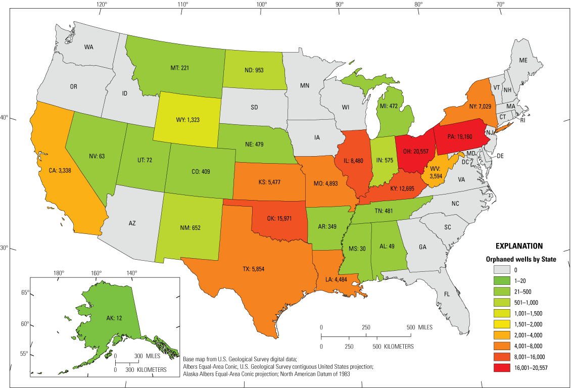
Map of the continental United States showing the number of orphaned wells in each state. States where no well data were collected are shown in grey, although those states may contain documented orphaned wells.
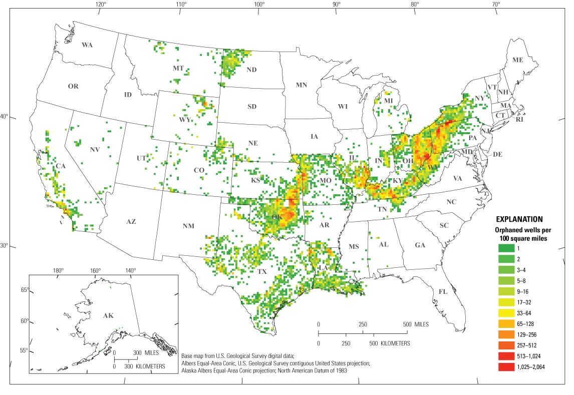
Map of the continental United States indicating the well density per 100 square mile grid cell of 117,672 unplugged orphaned wells in the 27 states included in the documented orphaned oil and gas well (DOW) dataset. Note the exponential scale of the coloring scheme used to preserve detail across both lower and higher well densities.
Discussion
The DOW dataset contains a limited number of parameters from the original state sources in order to produce a more complete compiled product. Location information from the DOW show there are higher numbers of wells in the eastern and midwestern states, where oil and gas exploration got an earlier start. This reflects a time in the second half of the 19th century when record keeping was less regulated. Limited record keeping and well-plugging regulations during that early period has resulted in more documented, and presumably undocumented, orphaned wells in those states (IOGCC, 2021). To provide a more in-depth discussion of the DOW dataset, additional information from other databases is included in the following text.
Analysis of the DOW dataset using data from the proprietary IHS Markit (2022) database (hereafter, IHS Markit) provides additional context to the orphaned well information in the DOW. Each well in the DOW dataset has a unique identifier which, in most instances, is an API number. This API number acts as a cross reference value with the IHS Markit database. Of the 117,672 wells in the DOW dataset, 110,976 wells (94 percent) have API numbers. Those missing an API number include all 5,477 wells in Kansas, all 575 wells in Indiana, a subset of 334 wells in Illinois, a subset of 242 wells in Louisiana, and a subset of 68 wells in Kentucky. Wells without an API number in the DOW dataset were not included in the following data parameter analysis of the orphaned wells.
IHS Markit provides additional well information not included in the DOW dataset. Well data from the proprietary IHS Markit database were accessed for the 110,976 wells in the DOW dataset with API numbers. The DOW and IHS Markit data are paired for this orphaned well parameter analysis because IHS Markit does not contain orphaned well status information. In addition, the proprietary nature of the commercial database precludes releasing well-specific information publicly, therefore IHS Markit data is neither included in the DOW dataset nor used to confirm any DOW dataset information.
The IHS Markit data provide “Completion Date” and “Driller Total Depth” for 69,347 of the orphaned wells in the DOW dataset; these parameters were combined with the DOW dataset to produce a DOW/IHS Markit merged subset used in the following discussion. Completion dates are depicted in figure 3, showing the number of orphaned wells by the year drilling was completed. In the merged subset data, 11,866 wells had a completion year of 1801; these wells were not included in figure 3 since they pre-date drilling in the United States, however the date is presumably a place holder for unknown drilling dates from the 1800s. Similarly, 1,983 wells in Pennsylvania have a completion year of 1901 in the DOW/IHS Markit subset; it is presumed that this is a similar place holder, but these wells are included in figure 3 to show their magnitude. Annual well completions, for wells that are currently orphaned, increase and decrease between 1860 and 2022, with a stark increase around 1940, followed by a rise in the 1950s, and a peak around 1980 (fig. 3). The three years with the most completed wells that were later orphaned happened in succession in 1980 (2,070 wells), 1981 (2,555 wells), and 1982 (2,151 wells). There was a small surge in annual well completions in 2007 followed by a decline through 2022 (fig. 3).
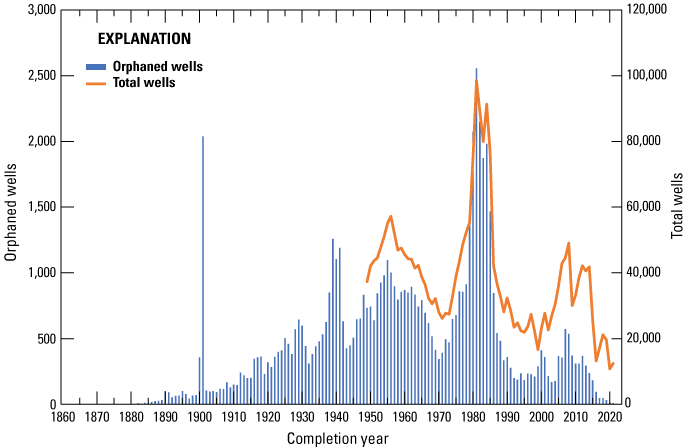
A histogram of 69,347 orphaned wells from the documented orphaned well (DOW) dataset displaying the number of orphaned wells drilled per year (1860–2022) using the completion date from IHS Markit (2022) in blue (left axis). Total annual wells from U.S. Energy Information Administration (2022) are in orange at a different scale (right axis).
To gain a sense of the proportion of wells drilled that later become orphaned, figure 3 also includes the total wells drilled annually from 1949 to 2021 (U.S. Energy Information Administration, 2022); this shows that annual drilling completions for wells that later became orphaned correlate with overall annual drilling completions for all wells. When drilling increases, so do the number of wells that eventually become orphaned (fig. 4). Figure 4 shows orphaned wells in the DOW/IHS subset plotted against the total number of wells drilled in the United States by the year they were completed. The ratio of the two datasets to each other represent the proportion of wells over time that later become orphaned. The overall ratio of DOW/IHS orphaned wells to total wells drilled annually in the United States is indicated by the best fit trendline near 2 percent (R2 = 0.91 linear regression with a forced 0 intercept); additional ratio lines of 0.5, 1, and 3 percent show that the best fitting ratio is not consistent across the years of the dataset (fig. 4). The ratio of orphaned wells in the DOW/IHS Markit subset to the total number of U.S. wells drilled annually in the years 1949 to 2021 ranges from a low of 0.08 percent in 2021 to a peak of 2.74 percent in 1980, with an average of 1.42 percent (fig. 5). The ratio is relatively consistent from 1949 to 1978 (except for a drop in the late 1960s), followed by a spike from 1979 to 1984, the same approximate years when total well drilling also spiked during the energy crisis. Since 1985, the ratio has decreased at a general overall rate of 0.05 percent per year to 2021, where the ratio is 0.08 percent. This declining orphaned well proportion is expected as new and more expensive wells are generally still producing and state agencies now require improved accountability from operators. Because the DOW dataset contains only documented orphaned wells, the orphaned ratios reported herein do not suggest that an average of 1.42 percent of all wells become orphaned in all years. These results are only relevant to documented orphaned wells and, therefore, are probably most applicable to years since the middle of the 1900s where few, if any, undocumented wells are expected to exist. Trends for the larger and, generally, older unknown population of undocumented orphaned wells may be significantly different.
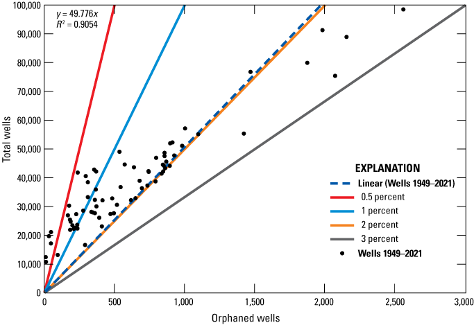
Graph showing the correlation between the orphaned wells in the documented orphaned oil and gas wells (DOW)/IHS Markit merged dataset and total number of wells in the United States by the year they were completed between 1949 and 2021 (U.S. Energy Information Administration, 2022). This relation can be used to generate a ratio of documented orphaned wells to total wells. Lines indicating ratios from 0.5 to 3 percent are included. In the top right of the graph are 6 points that plot with a ratio of between 2 and 3 percent, these points represent the highest ratios of orphaned to total wells and are associated with a spike in drilling from 1980 to 1985 in response to the energy crisis.
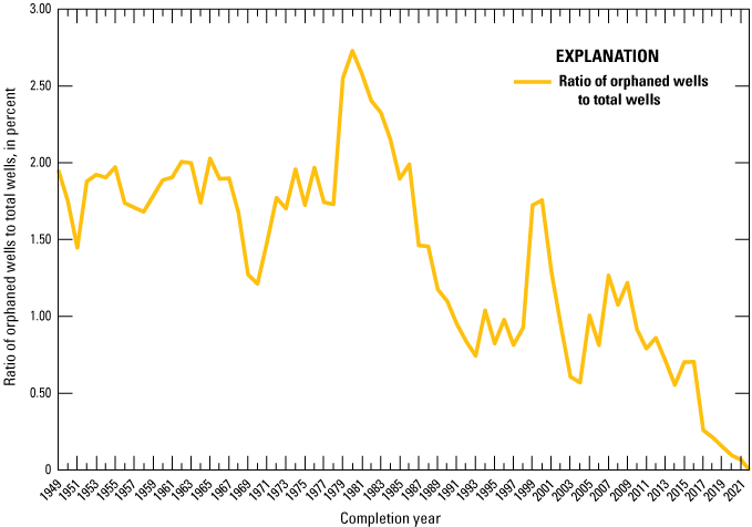
Graph showing the ratio of the orphaned wells in the documented orphaned oil and gas wells (DOW)/IHS Markit merged dataset to the total number of wells in the United States by completion year as a percentage.
The depths of the wells in the DOW/IHS Markit subset are plotted by the year of completion in figure 6. Well depth provides additional context for well remediation and risk assessment. Knowing which formations are penetrated by the well and what other wells or faults may be in the same depth space is important for determining potential leakage pathways. The data shown in figure 6 is the “Driller Total Depth” from IHS Markit, more commonly known as the measured depth, and is essentially the total length of the well bore rather than the true vertical depth from the surface. Ninety-eight percent of the data in figure 6 are from vertical wells, where the measured depth and vertical depth are marginally the same; however, horizontal wells can have significantly greater lengths, or measured depth, compared to their true vertical depth. The nationwide increase in the proportion of horizontal wells starting in 1990 is also seen in the dataset shown in figure 6. The graph shows that wells before 1925 were generally less than 5,000 feet deep, and measured depth increased through time. Many wells from 2010 to 2019 exceed 20,000 feet in length, with the longest well, a horizontal one, drilled to a measured depth of 23,670 feet in 2011. Despite these recent significant depths, 90 percent of wells in the DOW/IHS Markit subset, that also had measured depth information (59,881/66,205 wells), are less than 5,000 feet long.
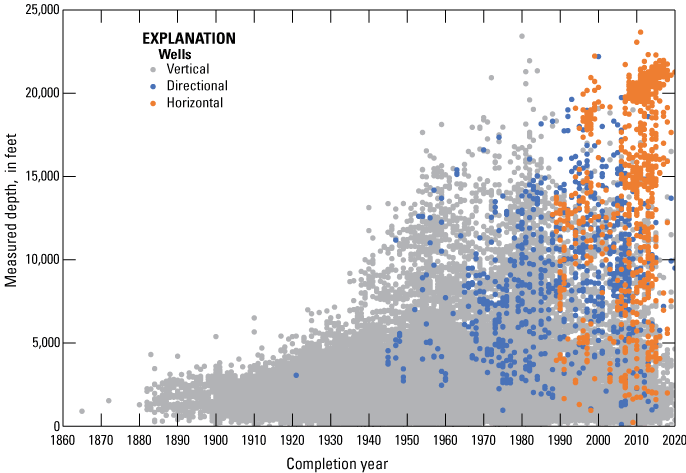
Graph of 66,205 orphaned wells with measured depth by completion year and well direction (vertical, directional, and horizontal) using IHS Markit (2022) data.
Summary
The U.S. Geological Survey (USGS) produced a dataset of documented, unplugged, orphaned oil and gas wells referred to as the documented orphaned oil and gas well (DOW) dataset (Grove and Merrill, 2022). As of 2022, the dataset includes 117,672 wells across 27 states that are presumed to include the majority of documented orphaned wells in the United States. These data capture the status of orphaned wells within the United States and are an initial effort at producing a publicly available dataset of national orphaned wells. This dataset was also compiled in support of the Bipartisan Infrastructure Law (BIL) “Title VI—methane reduction infrastructure, Sec. 40601: Orphaned well site plugging, remediation, and restoration” (Public Law 117-58, 135 Stat. 429), which included nearly $4.7 billion to reduce greenhouse gas (GHG) emissions and protect water and ecosystem resources through well plugging and remediation.
Combining the DOW with the proprietary IHS Markit (2022) database provided the opportunity to evaluate trends in the orphaned well data that could not be achieved with either data source on their own. The full 117,672 wells of the DOW were not able to be paired with the IHS Market data, but a subset of approximately 70,000 wells revealed trends over time in the proportion of all wells that eventually became orphaned. This ratio peaked in 1980 at 2.74 percent and corresponds with increased drilling during the energy crisis.
The DOW dataset can be applied to other federal activities related to orphaned wells and GHG emissions. The DOW contributed to the template generated by the U.S. Department of the Interior (DOI) for tracking orphaned wells and progress on their reclamation (DOI, 2022). Until the DOI's own orphaned well database is complete, the DOW dataset may be used by the DOI to fulfill additional obligations in the BIL. The DOW dataset could also be used in any future updates to the USGS's “Federal Lands Greenhouse Gas Emissions and Sequestration in the United States: Estimates for 2005–2014” (Merrill and others, 2018). These emissions and sequestration estimates follow the general methods described in the “Inventory of U.S. Greenhouse Gas Emissions and Sinks” (U.S. Environmental Protection Agency, 2022), and could be improved with a better understanding of orphaned well numbers and locations. The DOW dataset may lead to improved emissions estimates per well using DOW location data. Such research could benefit both the USGS and Environmental Protection Agency emissions estimates.
The overarching and long-term contribution of the DOW dataset is providing previously uncompiled, and therefore unavailable, information to everyday users. This legacy infrastructure data can help inform decisions about lands and their use. Leaking wells can release methane, one of the most potent GHGs, to the atmosphere. In addition to climate implications, these releases also have negative impacts on drinking water, ecosystems, and the economy (McMahon and others, 2018; Schout and others, 2019; Nallur and others, 2020; Raimi and others, 2021). Datasets like the DOW can provide a foundation for future research into these impacts and potentially their remediation.
References Cited
Boutot, J., Peltz, A.S., McVay, R., and Kang, M., 2022, Documented orphaned oil and gas wells across the United States: Environmental Science and Technology, v. 56, no. 20, p. 14228–14236, accessed November 2022 at https://doi.org/10.1021/acs.est.2c03268.
Brandt, A.R., Heath, G.A., Kort, E.A., O’Sullivan, F., Pétrons, G., Jordaan, S.M., Tans, P., Wilcox, J., Gopstein, A.M., Arent, D., Wofsy, S., Brown, N.J., Bradley, R., Stucky, G.D., Eardley, D., and Harriss, R., 2014, Methane leaks from North American natural gas systems: Science, v. 343, no. 6172, p. 733–735, accessed November 2022 at https://doi.org/10.1126/science.1247045.
de Smet, T.S., Nikulin, A., Romanzo, N., Graber, N., Dietrich, C., and Puliaiev, A., 2021, Successful application of drone-based aeromagnetic surveys to locate legacy oil and gas wells in Cattaraugus County, New York: Journal of Applied Geophysics, v. 186, accessed November 2022 at https://doi.org/10.1016/j.jappgeo.2020.104250.
Environmental Defense Fund/McGill University, 2021, Documenting orphan wells across the United States: Environmental Defense Fund web page, accessed March 17, 2022, at https://www.edf.org/orphanwellmap.
Fellow Environmental Partners, 2022, US orphan well map: Fellow Environmental Partners, Tulsa, Okla. web page, accessed November 2022 at https://www.fellowenviro.org/webmap.
Frischknecht, F.C., Grette, R., Raab, P.V., and Meredith, J., 1985, Location of abandoned wells by magnetic surveys acquisition and interpretation of aeromagnetic data for five test areas: U.S. Geological Survey Open-File Report 85-614A, 64 p., accessed November 2022 at https://doi.org/10.3133/ofr85614A.
Grove, C.A., and Merrill, M.D., 2022, United States documented unplugged orphaned oil and gas well dataset: U.S. Geological Survey data release, https://doi.org/10.5066/P91PJETI.
Markit, IHS, 2022, U.S. Well History and Production database: Englewood, Colo., IHS Markit web page, accessed September 2022 at https://ihsmarkit.com/index.html.
Interstate Oil and Gas Compact Commission [IOGCC], 2021, Idle and orphan oil and gas wells—State and provincial regulatory strategies: Interstate Oil and Gas Compact Commission, accessed March 17, 2022, at https://iogcc.ok.gov/idle-and-orphan-oil-and-gas-wells-2021.
Kaminski, V., Hammack, R.W., Harbert, W., Veloski, G.A., Sams, J., and Hodges, D.G., 2018, Geophysical helicopter-based magnetic methods for locating wells: Geophysics, v. 83, no. 5, p. B269–B279, accessed November 2022 at https://doi.org/10.1190/geo2017-0181.1.
Kang, M., Brandt, A.R., Zheng, Z., Boutot, J., Yung, C., Peltz, A.S., and Jackson, R.B., 2021, Orphaned oil and gas well stimulus—Maximizing economic and environmental benefits: Elementa, v. 9, no. 1, accessed December 2021 at https://doi.org/10.1525/elementa.2020.20.00161.
Kang, M., Christian, S., Celia, M.A., Mauzerall, D.L., Bill, M., Miller, A.R., Chen, Y., Conrad, M.E., Darrah, T.H., and Jackson, R.B., 2016, Identification and characterization of high methane-emitting abandoned oil and gas wells: Proceedings of the National Academy of Sciences, v. 113, no. 48, p. 13636–13641, accessed December 2021 at https://doi.org/10.1073/pnas.1605913113.
Kang, M., Kanno, C.M., Reid, M.C., Zhang, X., Mauzerall, D.L., Celia, M.A., Chen, Y., and Onstott, T.C., 2014, Direct measurements of methane emissions from abandoned oil and gas wells in Pennsylvania: Proceeding of the National Academies of Sciences, v. 111, no. 51, p. 18173–18177, accessed December 2021 at https://doi.org/10.1073/pnas.1408315111.
McMahon, P.B., Thomas, J.C., Crawford, J.T., Dornblaser, M.M., and Hunt, A.G., 2018, Methane in groundwater from a leaking gas well, Piceance Basin, Colorado, USA: Science of the Total Environment, v. 634, p. 791–801, accessed November 2022 at https://doi.org/10.1016/j.scitotenv.2018.03.371.
Merrill, M.D., Sleeter, B.M., Freeman, P.A., Liu, J., Warwick, P.D., and Reed, B.C., 2018, Federal lands greenhouse gas emissions and sequestration in the United States—Estimates for 2005–14: U.S. Geological Survey Scientific Investigations Report 2018–5131, 31 p., accessed November 2018 at https://doi.org/10.3133/sir20185131.
Nallur, V., McClung, M.R., and Moran, M.D., 2020, Potential for reclamation of abandoned gas wells to restore ecosystem services in the Fayetteville shale of Arkansas: Environmental Management, v. 66, p. 180–190, accessed November 2022 at https://doi.org/10.1007/s00267-020-01307-3.
Pekney, N.J., Diehl, J.R., Ruehl, D., Sams, J., Veloski, G., Patel, A., Schmidt, C., and Card, T., 2018, Measurement of methane emissions from abandoned oil and gas wells in Hillman State Park, Pennsylvania: Carbon Management, v. 9, no. 2, p. 165–175, accessed November 2022 at https://doi.org/10.1080/17583004.2018.1443642.
Raimi, D., Krupnick, A.J., Shah, J., and Thompson, A., 2021, Decommissioning orphaned and abandoned oil and gas wells—New estimates and cost drivers: Environmental Science and Technology, v. 55, no. 15, p. 10224–10230, accessed September 2022 at https://doi.org/10.1021/acs.est.1c02234.
Riddick, S.N., Mauzerall, D.L., Celia, M.A., Kang, M., Bressler, K., Chu, C., and Gum, C.D., 2019, Measuring methane emissions from abandoned and active oil and gas wells in West Virginia: Science of the Total Environment, v. 651, p. 1849–1856, accessed November 2022 at https://doi.org/10.1016/j.scitotenv.2018.10.082.
Saint-Vincent, P.M.B., Reeder, M.D., Sams, J.I., III, and Pekney, N.J., 2020, An analysis of abandoned oil well characteristics affecting methane emissions estimates in the Cherokee Platform in Eastern Oklahoma: Geophysical Research Letters, v. 47, no. 23, 10 p., accessed November 2022 at https://doi.org/10.1029/2020GL089663.
Schout, G., Griffioen, J., Hassanizadeh, S.M., de Lichtbuer, G.C., and Hartog, N., 2019, Occurrence and fate of methane leakage from cut and buried abandoned gas wells in the Netherlands: Science of the Total Environment, v. 659, p. 773–782, accessed November 2022 at https://doi.org/10.1016/j.scitotenv.2018.12.339.
Townsend-Small, A., Ferrara, T.W., Lyon, D.R., Fries, A.E., and Lamb, B.K., 2016, Emissions of coalbed and natural gas methane from abandoned oil and gas wells in the United States: Geophysical Research Letters, v. 43, no. 5, p. 2283–2290, accessed April 2021 at https://doi.org/10.1002/2015GL067623.
Townsend-Small, A., and Hoschouer, J., 2021, Direct measurements from shut-in and other abandoned wells in the Permian Basin of Texas indicate some wells are a major source of methane emissions and produced water: Environmental Research Letters, v. 16, accessed August 2022 at https://doi.org/10.1088/1748-9326/abf06f.
U.S. Department of the Interior [DOI], 2022, Data Reporting Template—Department of the Interior Office of Environmental Policy and Compliance: Department of Interior web page, accessed August 19, 2022, at https://www.doi.gov/sites/doi.gov/files/data-reporting-template-with-definitions.xlsx.
U.S. Energy Information Administration, 2022, Monthly energy review, July 2022—U.S. Energy Information Administration; able 5.2 crude oil and natural gas exploratory and development wells: U.S. Energy Information Administration web page, accessed July 25, 2022, at https://www.eia.gov/totalenergy/data/monthly/pdf/sec5_5.pdf.
U.S. Environmental Protection Agency, 2022, Inventory of U.S. greenhouse gas emissions and sinks—1990–2020: U.S. Environmental Protection Agency, EPA 430–R–22–003, variously paged, plus additional online data tables, accessed July 27, 2022, at https://www.epa.gov/system/files/documents/2022-04/us-ghg-inventory-2022-chapter-3-energy.pdf.
For more information about this publication, contact:
Director, Geology, Energy & Minerals Science Center
U.S. Geological Survey
956 National Center
Reston, VA 20192
Disclaimers
Any use of trade, firm, or product names is for descriptive purposes only and does not imply endorsement by the U.S. Government.
Although this information product, for the most part, is in the public domain, it also may contain copyrighted materials as noted in the text. Permission to reproduce copyrighted items must be secured from the copyright owner.
Suggested Citation
Merrill, M.D., Grove, C.A., Gianoutsos, N.J., and Freeman, P.A., 2023, Analysis of the United States documented unplugged orphaned oil and gas well dataset (ver. 1.1, April 2023): U.S. Geological Survey Data Report 1167, 10 p., https://doi.org/10.3133/dr1167.
ISSN: 2771-9448 (online)
Study Area
| Publication type | Report |
|---|---|
| Publication Subtype | USGS Numbered Series |
| Title | Analysis of the United States documented unplugged orphaned oil and gas well dataset |
| Series title | Data Report |
| Series number | 1167 |
| DOI | 10.3133/dr1167 |
| Edition | Version 1.0: February 17, 2023; Version 1.1: April 6, 2023 |
| Publication Date | February 17, 2023 |
| Year Published | 2023 |
| Language | English |
| Publisher | U.S. Geological Survey |
| Publisher location | Reston, VA |
| Contributing office(s) | Central Energy Resources Science Center, Eastern Energy Resources Science Center, Geology, Minerals, Energy, and Geophysics Science Center |
| Description | Report: vi, 10 p.; Data Release |
| Country | United States |
| Online Only (Y/N) | Y |
| Additional Online Files (Y/N) | Y |