

Terrestrial Invertebrate Diversity and Occurrence in Restored Hardwood Forest Floodplains, Indiana, United States, June–August 2016
Links
- Document: Report (2.18 MB pdf) , HTML , XML
- Data Release: USGS data release - Terrestrial invertebrate diversity and occurrence in restored hardwood forest floodplains, Indiana, United States, June–August 2016
- Download citation as: RIS | Dublin Core
Acknowledgments
This study was partially funded by the Department of the Interior’s Office of Restoration and Damage Assessment. Logistical assistance was provided by Doug Sundling (Bluffton, Indiana), Anna Gurney and Mike Clendenen (New Haven-Adams Township Park and Recreation Department, Indiana), and Ellen Jacquart and Nathan Herbert (The Nature Conservancy).
This study was also partially funded by the U.S. Geological Survey Columbia Environmental Research Center. Keith Grabner (U.S. Geological Survey) provided field assistance.
Abstract
This report provides a summary of terrestrial invertebrates collected at old field, mature, and restored hardwood forest floodplain sites in northeast Indiana. Invertebrate populations were sampled at selected sites using walking butterfly transects, pitfall-enhanced Malaise invertebrate traps (PEMITs), and sweep nets. We identified a total of 19 taxonomic groups of butterflies, with 1, 11, and 18 groups from the old field, mature, and restored sites, respectively. Samples collected with PEMITs captured 26 different invertebrate taxa and 4 vertebrate taxa on mature and restored sites (24 invertebrate taxa, each, on mature and restored sites; 3 and 2 vertebrate species on mature and restored sites, respectively). Sweep net sampling of restored sites captured 18 invertebrate taxa, including mantids (Mantodea), which were not detected using PEMITs. These data were collected in anticipation of assessing the progress of restored hardwood forest communities towards conditions associated with mature seasonally inundated floodplain forests in northeast Indiana.
Introduction
The U.S. Geological Survey (USGS) surveyed terrestrial invertebrates within hardwood forest floodplains in northeast Indiana, United States (Albers and others, 2021). Invertebrate populations were sampled in old field, mature, and restored habitats at four different sites: Bluffton Native Habitat Waterway along the Wabash River in Bluffton, Wells County, Indiana (long. 85.1466° W, lat. 40.7323° N); the Deetz Nature Preserve along the Maumee River in New Haven, Allen County, Ind. (long. 85.0352° W, lat. 41.0796° N; fig. 1); and the Bell (long. 84.8376° W, lat. 41.4861° N); and Holden (long. 84.8401° W, lat. 41.5479° N) tracts along Fish Creek near Hamilton, in DeKalb and Steuben Counties, Ind., respectively (all coordinates are World Geodetic System 1984 [WGS84]).
Old fields were habitats that were previously used for agriculture, but in which there had been little or no restoration other than opportunistic planting. Mature forests had many mature trees and a closed canopy, with no evidence of previous restorative planting efforts. Restored habitats were previously agricultural fields on which restoration projects such as native prairie or native tree plantings had been implemented between 1994 and 2009.
Detailed descriptions of the sites and habitat types are in supplement 1 of Green and others (2020). Data were collected using three survey techniques: walking visual butterfly transects, pitfall-enhanced Malaise invertebrate traps (PEMITs), and walking invertebrate sweep transects. This report describes the methodology used for data collection and provides tables containing a summary of the invertebrates found. Detailed data are available in a USGS data release (Albers and others, 2023). Final taxonomic assignment follows the International Taxonomic Information System (ITIS; https://www.itis.gov, accessed February 2023).
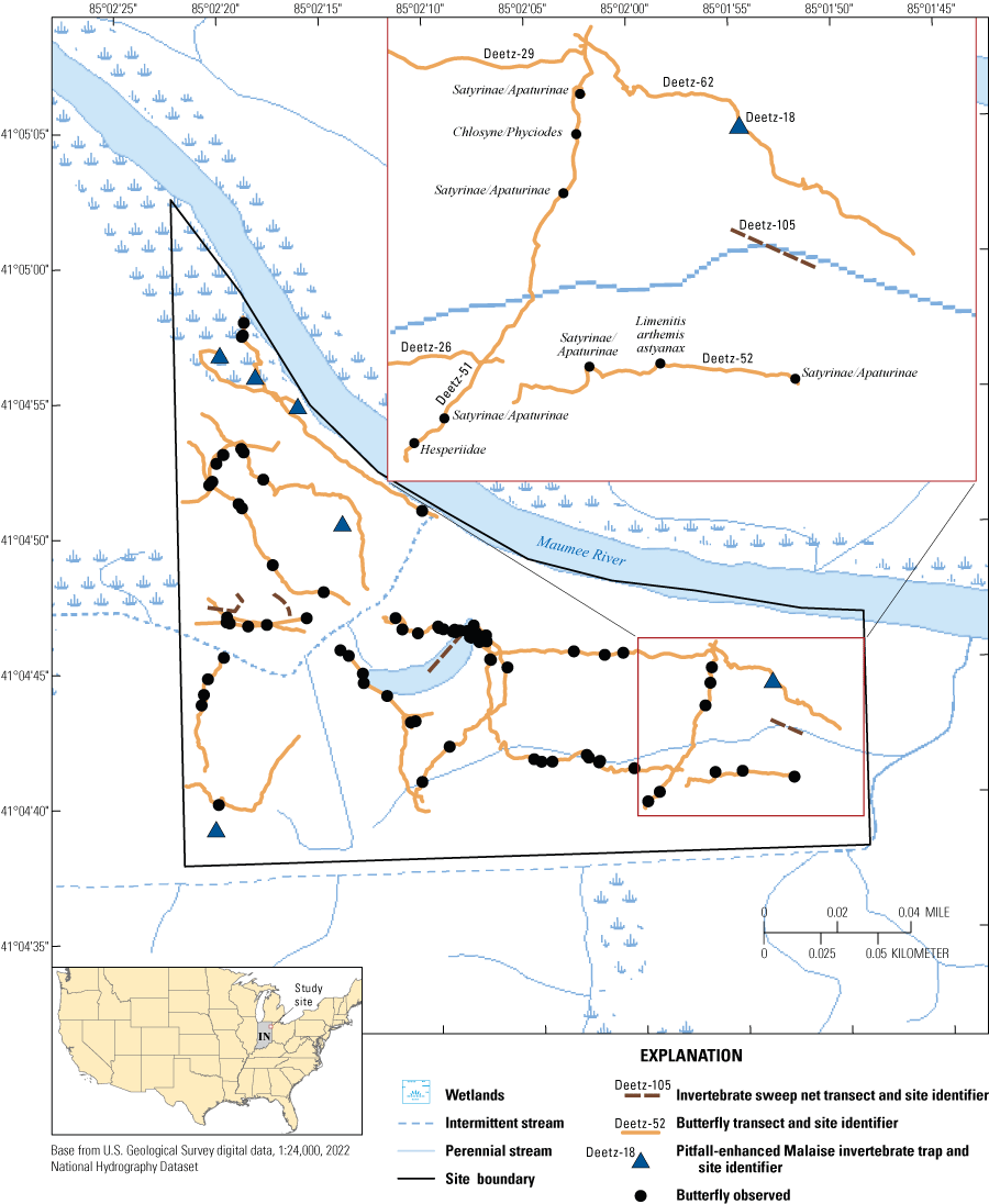
Illustration of the invertebrate survey data collected from the Deetz Nature Preserve to demonstrate potential mapping uses of the dataset (referred to as “Deetz” on the image). Inset map shows labels for each survey type and location as well as taxon identification for each butterfly observed.
Methods
Multiple types of equipment and techniques were used to sample the terrestrial invertebrates at the three sites. Each method had a target group of insects, but considered together give an overall assessment of species diversity.
Butterflies
Adult butterflies were sampled using visual observation transect protocols described in Van Swaay and others (2015) and identified using Belth (2013). While avoiding mowed hiking trails, a total of 61 transects were sampled over all the habitats (table 1; Albers and others, 2021), with old fields having only one sampling event owing to logistical time constraints. Each transect either started or ended at a randomly generated point location on the site, was a minimum of 100 meters (m) long, and was sampled between 0800 and 1700 hours (h) on sunny, non-windy days between June 21 and August 12, 2016. One person walked the transect with a mean speed of 0.423±0.106 meter per second (mean ± standard deviation, number of observations [n] = 59) and documented all observed butterflies within 5 m of the transect and as much as 10 m in front of the observer. Mean transect length was 247.49±135.79 m, and the mean transect area was 2,574.92±1357.90 square meters (m2) (n=61). A geographic positioning system (GPS; Trimble Juno 3B, Survey Supplies Ltd, Liverpool, United Kingdom) was used to record the transect start location and time, transect route, and transect end location and times. While sampling the transect, the GPS was also used to record the time and location of each butterfly encounter, visually identified taxa, and number of individuals in each taxon.
Table 1.
Taxa observed in butterfly transect sampling on northeast Indiana study sites.[n, number of butterfly transects sampled; spp., species; --. no data]
Live butterflies were identified to species level using visual observations of the individuals, except for groups of species similar in color, shape, and flight behavior, which prevented positive species-level identification. We grouped the following species: silvery checkerspot (Chlosyne nycteis) and pearl crescent (Phyciodes tharos) into the Chlosyne/Phyciodes spp. group; all small sulphurs (Coliadinae) into the Colias spp. group; all skippers (Hesperiidae) into the Hesperiidae group; all Satyrinae subfamily and two other species in the Nymphalidae family, hackberry emperor (Asterocampa celtis), and northern pearly-eye (Lethe anthedon anthedon) into the Satyrinae/Apaturinae spp. group; all question mark (Polygonia interrogationis), eastern comma (P. comma), and gray comma (P. progne) into the Polygonia spp. group; all Theclinae subfamily (hairstreaks) and Polyommatinae subfamily (blues) into the Theclinae/Polyommatinae spp. group; and all painted lady (Vanessa cardui) and American lady (V. virginiensis) into the Vanessa spp. group.
Invertebrates
Passive and active sampling techniques were used for invertebrate collections on study sites (table 2). Passive sampling methods are designed to catch a representative sample of all invertebrate functional groups in the sampled habitats (Leather, 2005), whereas active methods yield data only on invertebrates that are present within the sample area at the time of sampling.
Table 2.
Taxa caught in pitfall-enhanced Malaise invertebrate traps and sweep netting on northeast Indiana study sites.[n, number of pitfall-enhanced Malaise invertebrate traps or sweep net transects sampled]
For passive invertebrate sampling, we deployed 18 PEMITs (6 at Bluffton Native Habitat Waterway, 6 at Deetz Nature Preserve, 4 at Bell, and 2 at Holden) that consisted of a sea, land, and air Malaise trap (SLAM; BioQuip Products, Inc., Compton, California; 1.1 × 1.1 × 1.1 m), with additional pitfall traps as described below. The SLAM is fabricated with a white roof (108 × 32 mesh per square inch) and black Polyester no-see-um fabric (96 × 26 mesh per square inch; fig. 2). Each of the two perpendicular interception areas are 165 × 110 centimeters (cm), and a 500-milliliter (ml) collection bottle is attached at the peak of the trap. For this study, the large insect excluder was not used. The collection bottle contained 250 ml of soapy water (unscented, undyed dish soap) at a ratio sufficient to remove surface tension and increase invertebrate collection success. Plastic collection trays containing additional soapy water were positioned under the two crossed walls of the trap to collect falling invertebrates that encountered the fabric and as pit fall traps for ground crawling invertebrates. We dug two perpendicular trenches and inserted the trays into the ground so that the lip of the tray was even with ground surface and had good soil-tray contact. Individual plastic trays were 29.2 × 19.1 cm, contained soapy water that was at maximum 5.7 cm deep, and had a 250-micrometer (μm) mesh overflow screen in case of precipitation. The SLAM was aligned over the 14 trays that covered an area of 0.781 m2 below the trap (fig. 2). After sampling, all trap water was filtered with a 250-μm mesh to collect invertebrates. Invertebrates from the top collector and bottom trays were combined into one sample for the sampling day. All specimens were preserved in 70-percent ethanol.
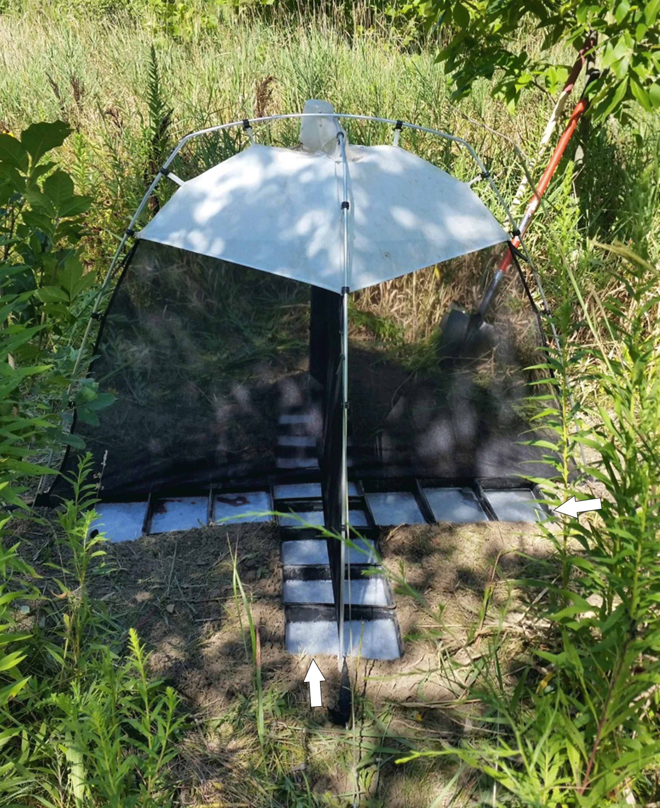
Pitfall-enhanced Malaise invertebrate trap used for passive invertebrate collections. The trap was deployed at the Deetz Nature Preserve site, New Haven, Indiana. Collection trays (arrows) containing soapy water inset into the ground act as pitfall traps beneath the above ground Malaise trap. Photograph by J. Albers, U.S. Geological Survey.
Traps were randomly placed within each of only two habitats (mature and restored) on studied sites owing to logistical time constraints (table 2). The traps were deployed between 0800 and 1200 h, and invertebrates were collected approximately every 24 h for 2 days. Traps were deployed three times at each site from June 21 to August 12, 2016, at approximately 2-week intervals. Mean trap first day deployment was 23.1±0.50 h (n=18), and mean trap second day deployment was 23.5±0.62 h (n=18).
Active sampling for terrestrial invertebrates employed seven sweep net transects in only the restored habitat owing to logistical time constraints (table 2). We used a net that was 0.38 m wide, 0.41 m high, and 0.64 m deep, with a 0.91-m handle and 24 count mesh (MidLakes Corporation, Knoxville, Tennessee). Sweep transects were 1.82 m wide, at approximately 1.6 sweeps per second or 80 sweeps per 50-m transect. Each sweep transect started from a random point and proceeded in a random direction. Direction was randomized by the sampler looking at the second hand on a clock. The sampler walked about 50 m while sweeping all vegetation and collecting all invertebrates within approximately 0.91 m of the transect between 1200 and 1700 h from July 17 to August 11, 2016. Mean transect length was 44.1±8.86 m, and the mean transect area was 81.8±16.20 m2 (n=7). Invertebrates were euthanized with gaseous acetone while still in the net and then were removed and preserved in 70-percent ethanol.
Biaggini and others (2007) suggest that identification of individual invertebrates to order is adequate to determine differences in invertebrate communities owing to land use changes. Consequently, all terrestrial invertebrate specimens were identified to order or the lowest taxonomic level possible following keys in Borror and White (1998), Bouchet and others (2005), Chu (1949), Cupul-Magaña and Flores-Guerrero (2016), Ramel (2017), Sierwald (2007), Stehr (1987, 1991), Treadwell (1996), and Triplehorn and others (2005). Identifications were made in the invertebrate taxonomy laboratory at the U.S. Geological Survey Columbia Environmental Research Center in Columbia, Missouri.
Results
Detailed data collected from butterfly, PEMITs, and sweep net sampling were compiled, together with relevant metadata, in a USGS data release (Albers and others, 2023). We identified a total of 19 taxonomic groups of butterflies, with 1, 11, and 18 known groups from the old field, mature, and restored sites, respectively (table 1). PEMITs captured 26 different invertebrate taxa and 4 vertebrate taxa on mature and restored sites (24 invertebrate taxa, each, on mature and restored sites; 3 and 2 vertebrate species on mature and restored sites, respectively; table 2). Sweep net sampling of restored sites captured 18 invertebrate taxa, including mantids (Mantodea), which were not detected using PEMITs (table 2).
Summary
This report provides a summary of terrestrial invertebrates collected at old field, mature, and restored hardwood forest floodplain sites in northeast Indiana. Invertebrate populations were sampled using different equipment types and techniques at the three sites, including walking butterfly transects, pitfall-enhanced Malaise invertebrate traps (PEMITs), and sweep nets. Each method targeted a group of insects, either actively or passively collecting insects, and used together, gave an overall assessment of species diversity.
A total of 19 taxonomic groups of butterflies were identified, with 1, 11, and 18 groups from the old field, mature, and restored sites, respectively. Samples collected with PEMITs captured 26 different invertebrate taxa and 4 vertebrate taxa on mature and restored sites (24 invertebrate taxa, each, on mature and restored sites; 3 and 2 vertebrate species on mature and restored sites, respectively). Sweep net sampling of restored sites captured 18 invertebrate taxa, including mantids (Mantodea), which were not detected using PEMITs. These data were collected in anticipation of assessing the progress of restored hardwood forest communities toward conditions in mature seasonal floodplain forests in northeast Indiana.
References Cited
Albers, J.L., Wildhaber, M.L., Green, N.S., Struckhoff, M.A., and Hooper, M.J., 2023, Terrestrial invertebrate diversity and occurrence in restored hardwood forest floodplains, Indiana, United States, June–August 2016: U.S. Geological Survey data release, https://doi.org/10.5066/P9YZX7G6.
Biaggini, M., Consorti, R., Dapporto, L., Dellacasa, M., Paggetti, E., and Corti, C., 2007, The taxonomic level order as a possible tool for rapid assessment of Arthropod diversity in agricultural landscapes: Agriculture, Ecosystems & Environment, v. 122, no. 2, p. 183–191. [Also available at https://doi.org/10.1016/j.agee.2006.12.032.]
Green, N.S., Wildhaber, M.L., Albers, J.L., Pettit, T.W., and Hooper, M.J., 2020, Efficient mammal biodiversity surveys for ecological restoration monitoring: Integrated Environmental Assessment and Management, 13 p. [Also available at https://doi.org/10.1002/ieam.4324.]
Leather, S.R., ed., 2005, Insect sampling in forest ecosystems: Malden, Massachusetts, Blackwell Science Ltd., 315 p. [Also available at https://doi.org/10.1002/9780470750513.]
Ramel, G., 2017, Key to orders of insects—Insect identification key: accessed December 20, 2022, at https://earthlife.net/insects/orders-key.
Sierwald, P., 2007, Milli-PEET—Key to millipede orders: accessed December 20, 2022, at https://www.fieldmuseum.org/science/special-projects/milli-peet-class-diplopoda/milli-peet-millipedes-made-easy/milli-peet-key.
Treadwell, L., 1996, An introduction to the identification of caterpillars: Department of Applied Ecology and Environmental Sciences, accessed March 25, 2021, at http://www.insectsexplained.com/caterpillars.pdf.
Van Swaay, C., Regan, E., Ling, M., Bozhinovska, E., Fernandez, M., Marini-Filho, O.J., Huertas, B., Phon, C.K., K”orösi, A., Meerman, J., Pe’er, G., Uehara-Prado, M., Sáfián, S., Sam, L., Shuey, J., Taron, D., Terblanche, R., and Underhill, L., 2015, Guidelines for standardized global butterfly monitoring: Leipzig, Germany, Group on Earth Observations Biodiversity Observation Network, GEO BON Technical Series 1, 32 p.
For more information about this publication, contact:
Director, USGS Columbia Environmental Research Center
4200 New Haven Road
Columbia, MO 65201
573–875–5399
For additional information, visit: h ttps://www .usgs.gov/ centers/ cerc
Publishing support provided by the
Rolla Publishing Service Center
Disclaimers
Any use of trade, firm, or product names is for descriptive purposes only and does not imply endorsement by the U.S. Government.
Although this information product, for the most part, is in the public domain, it also may contain copyrighted materials as noted in the text. Permission to reproduce copyrighted items must be secured from the copyright owner.
Suggested Citation
Albers, J.L., Wildhaber, M.L., Struckhoff, M.A., Westrich, D.J., Green, N.S., Poulton, B.C., and Hooper, M.J., 2023, Terrestrial invertebrate diversity and occurrence in restored hardwood forest floodplains, Indiana, United States, June–August 2016: U.S. Geological Survey Data Report 1168, 7 p., https://doi.org/10.3133/dr1168.
ISSN: 2771-9448 (online)
Study Area
| Publication type | Report |
|---|---|
| Publication Subtype | USGS Numbered Series |
| Title | Terrestrial invertebrate diversity and occurrence in restored hardwood forest floodplains, Indiana, United States, June–August 2016 |
| Series title | Data Report |
| Series number | 1168 |
| DOI | 10.3133/dr1168 |
| Publication Date | March 09, 2023 |
| Year Published | 2023 |
| Language | English |
| Publisher | U.S. Geological Survey |
| Publisher location | Reston, VA |
| Contributing office(s) | Columbia Environmental Research Center |
| Description | Report: vi, 7 p.; Data Release |
| Country | United States |
| State | Indiana |
| Online Only (Y/N) | Y |