Post Carr Fire Bioassessment Data Report, Whiskeytown National Recreation Area, Shasta County, California
Links
- Document: Report (4.8 MB pdf) , HTML , XML
- Data Release: USGS Data Release - Post Carr Fire Bioassessment Data, Whiskeytown National Recreation Area, Shasta County, California, 2020
- Download citation as: RIS | Dublin Core
Acknowledgments
Funding was provided by the U.S. Geological Survey (USGS) Emergency Disaster Supplemental Science program. We would like to especially acknowledge the direction and insight provided by Dr. Larry Brown, who was the driving force behind this work. Many individuals at the USGS helped to collect and process samples for these studies, including Veronica Violette, Greg Brewster, and Kathryn Crepeau. We thank personnel from Whiskeytown National Recreation Area who provided logistical support including Jennifer Gibson and Brian Rasmussen. Specimens were collected for this study under authority of Scientific Collecting Permit S-190290002-20016-001 granted to Larry Brown by the California Department of Fish and Wildlife.
Abstract
The U.S. Geological Survey, in cooperation with the National Park Service, analyzed water and sediment chemistry, benthic macroinvertebrate assemblages, fish and amphibian assemblages, fish and invertebrate tissues, instream habitat characteristics, and sediment heterogeneity at 10 stream sites within Whiskeytown National Recreation Area, Shasta County, California, during August 2020, 2 years after the Carr Fire. The post-Carr Fire data were compared to available pre-Carr Fire data to help determine if there have been wildfire-induced changes in the aquatic communities within the Whiskeytown National Recreational Area. Benthic sediment results for metals of biological concern were compared with consensus-based probable effect concentrations from previously published sediment-quality guidelines. Results from 2020 sampling indicated exceedances of these guidelines at one site for cadmium, chromium, copper, and zinc; there were exceedances of the guidelines at three sites for nickel. Concentrations of metals of biological concern in fish and invertebrate tissue samples generally varied among sites and years, with no pattern with specific reference to the Carr Fire. Average zinc and lead concentrations in composite invertebrate samples were slightly higher in 2020 than in previous years, and arsenic levels were lower in 2020 for invertebrate and fish tissues. Post-Carr Fire stream-habitat and sediment-size characterization values did not change substantially when compared to pre-Carr Fire values, or had high variation among all sites and years. Fish and amphibian inventories demonstrated that fewer total fish and amphibians were collected post-Carr Fire, but higher numbers of native Sacramento Sucker (Catostomus occidentalis) and Sacramento Pikeminnow (Ptychocheilus grandis) were collected than in previous years. The combined histories of mining and frequent wildfires in the area pose an increased risk for metal contamination throughout the aquatic system. Continued monitoring for multilevel trophic effects of contaminants can provide information about the overall health of the Whiskeytown National Recreation Area and surrounding region.
Introduction
In July 2018, the Carr Fire burned 229,651 acres within California’s Shasta and Trinity Counties. Soil-burn severity was classified as moderate (39.2 percent) to severe (4.8 percent) for 44 percent of the Carr Fire burn area (Burned Area Emergency Response Team, 2018; fig. 1). Of the 42,000 acres at Whiskeytown National Recreation Area, 93 percent was burned because of this wildfire (National Park Service, 2021). The fire resulted in clearly visible devastation of terrestrial habitats and loss of much of the Whiskeytown National Recreation Area infrastructure. The U.S. Geological Survey (USGS), in cooperation with the National Park Service, analyzed water and sediment chemistry, benthic macroinvertebrate assemblages, fish and amphibian assemblages, fish and invertebrate tissues, instream habitat characteristics, and sediment heterogeneity at 10 stream sites within Whiskeytown National Recreation Area, Shasta County, California, during August 2020, 2 years after the Carr Fire. This report documents the results of a post-Carr Fire repeatable survey of the assemblages of resident aquatic biota, instream habitat, benthic sediment, and water-quality conditions in the streams of the upper Clear Creek drainage basin, Shasta County, California (fig. 2).
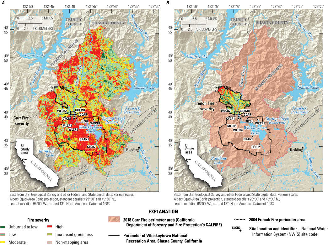
A, Burn severity of the Carr Fire and B, burn severity of the 2004 French Fire, in relation to the 2020 sample site locations within Whiskeytown National Recreation Area, Shasta County, California (U.S. Geological Survey, 2016; U.S. Geological Survey Burn Severity Portal, 2022). Site code abbreviations: BRAN1, Brandy Creek near Whiskeytown; CCAR, Clear Creek above Carr Powerhouse near French Gulch; CLCR2, Clear Creek at Peltier Valley Road near Shasta; CCTMR, Clear Creek near French Gulch; CYCR1, Crystal Creek near mouth near French Gulch; GZGL, Grizzly Gulch near Whiskeytown; MLCR1, Mill Creek near French Gulch; WKCR1, Whiskey Creek near Whiskeytown; WLCR2, Willow Creek near French Gulch; WLCR4, Willow Creek at Trinity Mountain Road near French Gulch.
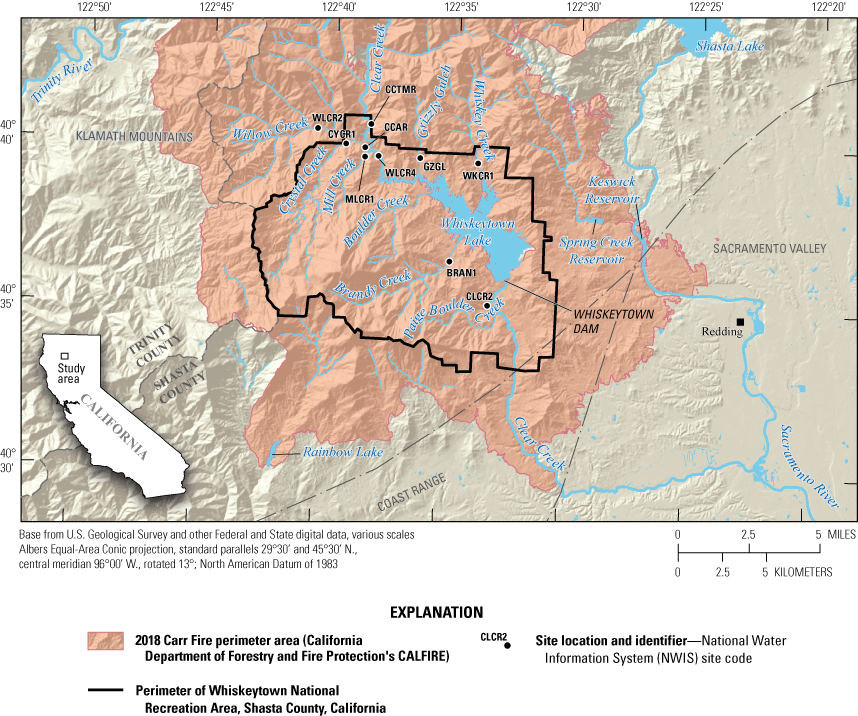
Location of survey sites within Whiskeytown National Recreation Area, Shasta County, California (U.S. Geological Survey, 2016). Site code abbreviations: BRAN1, Brandy Creek near Whiskeytown; CCAR, Clear Creek above Carr Powerhouse near French Gulch; CLCR2, Clear Creek at Peltier Valley Road near Shasta; CCTMR, Clear Creek near French Gulch; CYCR1, Crystal Creek near mouth near French Gulch; GZGL, Grizzly Gulch near Whiskeytown; MLCR1, Mill Creek near French Gulch; WKCR1, Whiskey Creek near Whiskeytown; WLCR2, Willow Creek near French Gulch; WLCR4, Willow Creek at Trinity Mountain Road near French Gulch.
Understanding the effects of wildfires on aquatic ecosystems is of particular interest in California, other Western States, and globally because of expected increases in frequency and severity of wildfires related to climate change (van Mantgem and others, 2013; Scholten and others, 2021; Jones and others, 2022). Wildfires can substantially affect water quality and aquatic ecosystems in reservoirs and streams (Bixby and others, 2015). These effects can include increased loading of nutrients, dissolved organic carbon, major ions, and metals; increased inputs of sediment that alter stream substrate characteristics and exposure of organisms to elevated concentrations of contaminants and increased turbidity; and loss of stream canopy (Murphy and others, 2015; Burton and others, 2016).
Whiskeytown Lake is a reservoir in the foothills of the Klamath Mountains, 9 miles west of Redding, California. Water quality at Whiskeytown Lake is closely monitored because of the many beneficial uses for water from Whiskeytown Lake including (1) providing recreation for 800,000 visitors annually; (2) serving as the domestic-water supply for several nearby cities; (3) supplying water to other parts of California as part of the Federal Central Valley Project (Bureau of Reclamation, 2023); and (4) providing habitat for species of concern. Historically, Clear Creek supported a substantial fall run for the federally threatened Chinook salmon (Oncorhynchus tshawytscha; Yoshiyama and others, 1998), and spring-run Chinook salmon have been observed in Clear Creek below Whiskeytown Dam. Whiskeytown Lake and its surrounding streams support raptors and piscivorous mammals as well as provide habitat for three California species of concern: (1) Foothill Yellow-legged Frog (Rana boylii), (2) Tailed Frog (Ascaphus truei), and (3) Western Pond Turtle (Actinemys marmorata; Thomson and others, 2016).
Throughout its history, the Whiskeytown National Recreation Area has been affected by an extensive history of mining, logging, dam-building, and fire suppression. Past and present activities from within and outside Whiskeytown National Recreation Area’s boundary have left many dredge tailing piles, pits, adits, tunnels, roads, and associated contaminants. Previous studies have documented that heavy metals bioaccumulated in fish, amphibians, and benthic macroinvertebrates in the upper Clear Creek watershed and within Whiskeytown National Recreation Area (May and others, 2012; Hothem and others, 2015). These studies identified sources of contamination, determined the extent to which heavy metals were in the watershed, and the magnitude to which they have accumulated in biota. Elevated concentrations of arsenic, lead, zinc, chromium, nickel, and mercury have been measured in sediment, invertebrates, and fish collected from these sites (Moore and Hughes, 2003; Hothem and others, 2008, 2015; May and others, 2012).
Wildfire effects on Whiskeytown Lake and its surrounding area are concerning to the managers at Whiskeytown National Recreation Area because of potential impairment to the natural resources including the health and toxicity of federally listed anadromous fish (downstream from Whiskeytown Dam) and piscivorous mammals and birds. Stream impairments include runoff of nutrients and other substances from burned areas, increased inputs of fine sediment resulting from surface erosion, and increased inputs of mining-related metals from runoff and eroded sediments (East and others, 2021). Increased concentrations of metals in water and sediment result in bioaccumulation of potentially harmful metals in fish and other stream biota that are potentially harmful to wildlife and human consumers. Impairments to the Whiskeytown Lake are similar because the tributaries are transporting sources of metals into the lake. At Whiskeytown Lake, the primary concerns for resource managers are water quality for downstream users and impairment of recreational activities caused by bioaccumulation of potentially harmful metals, primarily for recreational fishing.
Study Area
The study area is in northwestern California in the upper Clear Creek watershed, primarily within Whiskeytown National Recreation Area (fig. 2). Whiskeytown National Recreation Area is at the convergence of three physiographic provinces: (1) the Cascade Range, (2) the Coast Range, and (3) the Sacramento Valley, which is considered the northern part of the Central Valley (California Geological Survey, 2002). The study area has a Mediterranean climate with hot dry summers and cool winters with moderate rainfall. Mean annual rainfall in the area is approximately 1,500 millimeters (mm). The study area lies within the Klamath-Siskiyou ecoregion (not shown in figures), an area of substantial biodiversity, especially for terrestrial plants (DellaSala and others, 1999). In the context of fish zoogeography, the study area lies within the Central Valley subprovince of the larger Sacramento–San Joaquin province (not shown in figures; Moyle, 2002). The Central Valley fish fauna includes 28 native species, many of them endemic to California, and 40 non-native species (Moyle, 2002). The region’s moderately rich herpetofauna of 38 species is attributed to the overlap between northern and southern taxa and the presence of appropriate, complex habitat (Bury and Pearl, 1999).
Purpose and Scope
The objective of this report is to describe assessments of water quality, sediment quality, benthic macroinvertebrate assemblages, fish and amphibian communities, and stream-habitat characterization of tributaries to Whiskeytown Lake after the Carr Fire. The post-Carr Fire data will be compared to available pre-Carr Fire data. Pre-Carr Fire samples were collected in spring and fall 2004–06, and post-Carr Fire samples were collected in August 2020. Constituents analyzed include metals of known biological concern such as arsenic, cadmium, chromium, copper, nickel, selenium, and zinc that were collected from water, sediment, and invertebrate and fish tissues. This information can help determine if there has been wildfire-induced changes in the aquatic communities within Whiskeytown National Recreation Area.
Methods
There were 10 study sites selected on 7 tributaries to Whiskeytown Lake that composed most inflow to Whiskeytown Lake (table 1; fig. 2). The Carr Fire burned the Whiskeytown National Recreation Area, and all 10 sites that were sampled in 2020 were within the Carr Fire perimeter. Of the 10 sites sampled in 2020, 8 sites were also sampled in 2004 and 2005. The two sites that were first sampled in 2020 include Clear Creek near French Gulch (CCTMR) and Willow Creek at Trinity Mountain Road near French Gulch (WLCR4; table 1). Two sampling sites, Brandy Creek near Whiskeytown (BRAN1) and Clear Creek above Carr Powerhouse near French Gulch (CCAR), were sampled from 2004 to 2006. The 2020 sampling of tributaries to Whiskeytown Lake was compared to available data collected in 2004–06 at the same sites.
Riparian canopy closure is measured with a concave spherical densiometer and is a measurement of riparian vegetation made near the stream to provide an estimate of the amount of shading in a selected area (Fitzpatrick and others, 1998).
Pools, riffles, and runs are types of geomorphic channel units considered for National Water Quality Assessment Program (NAWQA) habitat sampling. A pool is a part of the stream reach with low velocity, usually with water deeper than the surrounding area. A riffle is a shallow part of the stream where water flows swiftly over partial or completely submerged obstructions to produce surface turbulence. A run is a relatively shallow part of the stream with moderate velocity and little or no surface turbulence (Fitzpatrick and others, 1998).
Table 1.
Sites sampled within Whiskeytown National Recreation Area, Shasta County, California, 2020, including U.S. Geological Survey (USGS) station name, site code, USGS station identification (ID) site, and latitude (lat) and longitude (long; U.S. Geological Survey, 2016).[NAD 83, North American Datum of 1983]
Stream sampling reach lengths were determined as 20 times the wetted-channel width in accordance with the National Water-Quality Assessment Program (NAWQA) stream habitat protocol (Fitzpatrick and others, 1998; Moulton and others, 2002). Study sites consisted of a single section of stream that was 400 meters (m) long for main-stem Clear Creek and 100–150 m long for the smaller tributaries. Stream sites were sampled in August 2020 for water nutrient and trace-element chemistry, bed sediment trace-element chemistry, benthic macroinvertebrate assemblages, fish and invertebrate tissue for metals analysis, and stream-habitat characterization.
Water Sample Collection and Analysis
Water-quality samples were collected and processed following standard USGS protocols described in the National Field Manual (U.S. Geological Survey, variously dated). Before collecting samples from the field, all field equipment was cleaned according to USGS protocols and then rinsed with native water immediately before samples were collected. One water sample was collected at each site using a mid-stream dip method and filtered and preserved as required for the analysis of the constituent as described in the constituent referenced methodology (Shelton, 1994; McCormick and others, 2006). Sampling included one field blank and one replicate sample at two sites for quality assurance purposes. The number of blank and replicate samples taken was 20 percent of water-quality samples. Field blanks were collected according to USGS protocols as described in U.S. Geological Survey (variously dated). Samples were analyzed for nutrients, major ions, and trace metals at the USGS National Water-Quality Laboratory in Denver, Colorado. Nutrients were determined from 0.45-micrometer (μm) filtered and unfiltered samples using methods of Fishman (1993) and Patton and Kryskalla (2003). Water collected for major ions was acidified in the field and determined from filtered water samples in the laboratory using the methods of Fishman and Friedman (1989), Hoffman and others (1996), and Garbarino and Struzeski (1998). Concentrations of dissolved arsenic, boron, lithium, selenium, strontium, thallium, and vanadium were determined using methods in Garbarino (1999). Concentrations of all other trace metals were determined from acidified, filtered samples using the methods of Fishman and Friedman (1989) and Garbarino and others (2006).
Bed Sediment Sample Collection and Chemical Analyses
Bed sediment samples were collected using protocols described by Axtmann and others (1997). Generally, one composite sample was collected per site. At two sites, composite samples were collected in triplicate to compute variability of chemical concentrations for quality assurance. Sediment samples were collected by scooping material with an acid-washed polypropylene scoop from the submerged surfaces of sediment deposits reported along pools or low-velocity areas near the edge of the stream. Whenever possible, samples were collected from both sides of the stream. Individual samples of bed sediment were collected by scooping material from the surfaces of 5–10 deposits along pools or low-velocity areas within the study reach. The 5–10 individual samples were combined to form a single composite sample. Each composite sample was wet sieved onsite through a 63-μm mesh nylon-sieve cloth directly into a sample jar using ambient stream water. The fraction of bed sediment in each composite sample that was finer than 0.063 mm was collected in an acid-washed 500-milliliter (mL) polyethylene bottle.
Samples were placed on dry ice and frozen before shipping to the USGS Analytical Trace Element Chemistry Laboratory in Boulder, Colorado, for chemical analyses following analytical methods including the quality assurance and quality control (QA/QC) approach described by Roth and others (2022). Inorganic sediments were digested in a high temperature and pressure microwave environment using an Ethos EZ Milestone digestion system. Samples sets of 10 samples include 1 blank and at least 1 National Institute of Standards and Technology (NIST) standard reference material (SRM) sample to verify digestion concentrations. Organic samples are digested similarly except only nitric acid (HNO3) was used, and the acid was added several hours ahead of time to rid the sample of excess carbon dioxide (CO2). Sample collection and processing equipment were cleaned in the field between each sampling site using methods described by Shelton and Capel (1994).
Macroinvertebrate Sampling and Analysis
Benthic macroinvertebrates (greater than 0.5 mm) were collected using a reach-wide quantitative multihabitat sample, following methods outlined in Wulff and others (2012), similar to the USGS California Stream Quality Assessment methodology (May and others, 2020), with the exception of sieving samples only once through a 0.5-mm sieve. A D-frame net was used to collect 11 kick-net samples with 500-μm mesh openings. Samples were collected 1 m downstream from each of the 11 cross-section habitat transects, alternating in a left, center, right pattern. All kick-net samples collected at transects were combined into a single composite sample and sieved through a 0.5-mm sieve before being preserved with a 95-percent ethanol solution. Macroinvertebrates were analyzed by Benthic Aquatic Research Services in Lawrence, Kansas. Samples were processed according to a standardized protocol consistent with Woodard and others (2012). A minimum of 600 organisms were counted per sample, except when the sample contained fewer than 600 organisms. Taxonomy conformed to the Southwest Association of Freshwater Invertebrate Taxonomists Level 2 taxonomic effort (Richards and Rodgers, 2011, appendix I). Organisms were classified to the lowest practical taxon, usually genus for well-known groups or some higher taxonomic level for some of the lesser known or difficult-to-identify taxa. Macroinvertebrate data were summarized as percentage abundance at the appropriate taxa level. The percentage abundance format standardizes counts to a common scale (percentage), provides an easily understood measure of relative abundance for comparison within and among stations, and is a format commonly used for statistical analyses (Moulton and others, 2000; Rehn and others, 2005).
Invertebrates (Hemiptera, family Gerridae) were collected for tissue-metals analysis following procedures described in Hothem and others (2008). Samples were sorted and cleaned before being composited by site, with the goal of obtaining a minimum of 1-gram (g) wet biomass. Each sample consisted of 15–27 individuals. Samples were weighed on an electronic balance, placed into chemically cleaned glass jars, and stored frozen until they could be shipped to the laboratory for analysis following methods described by Roth and others (2022).
Fish and Amphibian Sampling
Fish communities were assessed using standard electrofishing techniques using a Smith-Root Type LR-24 electrofisher. Amphibians were not targeted in sampling but were measured and released if inadvertently captured while collecting fish. Two passes were done to document species richness and relative abundance of fishes and to collect riffle sculpin (Cottus gulosus) for tissue analysis. Total length and standard length in millimeters were measured for fish. Snout-vent length (in millimeters) was measured on Pacific Giant Salamander (Dicamptodon tenebrosus) larvae. A minimum of the first 30 individuals of each species were measured to the nearest 0.1 g on an electronic balance.
Riffle Sculpin was the target species for tissue metals analysis because it is widely distributed in the sampled streams. Tissue samples consist of whole-body composite samples with a target of at least five similarly sized individuals per sample. Samples were placed in individual glass sample jars and stored frozen for no more than 30 days before they were sent to the USGS Analytical Trace Element Chemistry Laboratory for analysis following methods described by Roth and others (2022).
Stream-Habitat Characterization
Instream habitat measurements were made at each site according to the NAWQA stream habitat protocol (Fitzpatrick and others, 1998; Moulton and others, 2002) and included reach length, elevation, discharge, percentage riffle/run/pool, mean wetted-channel width, mean open canopy, mean riparian canopy closure, mean depth, mean water velocity, and dominant substrate. Stream sampling reach lengths ranged from 100 to 400 m and were determined as 20 times the wetted-channel width. Habitat variables were measured at 11 transects per sample site, with transects placed at equally spaced intervals within a reach. Stream width (wetted channel) was measured directly from a transect tape, and open canopy angle was measured from midstream with a clinometer. A densiometer was used to calculate riparian canopy closure percentage. Percentage area of habitat features such as woody debris and overhanging vegetation were visually estimated from mid-channel within a section of the stream extending 2 m upstream and downstream from the transect tape. Depth, velocity, and substrate were measured at a minimum of three points on each transect. Depth was measured with a wading rod and velocity with an electronic meter (Marsh-McBirney) at 60 percent of total depth measured from the bottom. The dominant substrate was classified at each transect point. Habitat variables were analyzed as the geometric mean of the 11 transect values or the geometric mean of the 33 (or more) point values.
In addition, a more detailed characterization of sediment size classes was done at each site by quantitatively measuring channel substrate particle size using pebble counts (Wolman, 1954), as outlined in the NAWQA stream habitat protocol (Fitzpatrick and others, 1998). A minimum of 20 substrate-size measurements were collected at each transect, resulting in approximately 200 individual substrate-size measurements per survey site. The substrate-size data were collected to allow assessment of changes in fine sediment associated with future runoff events.
Results and Discussion
All data collected for this study are available in the associated data release (Wulff and others, 2023). Blank and replicate QA/QC results were within acceptable parameters for this study.
Water Chemistry
The highest concentration of arsenic, 3.1 micrograms per liter (µg/L), was measured at CCTMR. The Willow Creek near French Gulch sample site (WLCR2) had the highest concentrations of copper (13.5 µg/L) and zinc (27.1 µg/L). The Clear Creek at Peltier Valley Road near Shasta sample site (CLCR2) had the highest concentration of nickel (2.1 µg/L), and the Whiskey Creek near Whiskeytown sample site (WKCR1) had the highest concentration of selenium (0.5 µg/L). The range of concentrations across all sites for metals is reported as follows: arsenic (less than [<] 0.1–3.1 μg/L); copper (<0.4–13.5 μg/L); nickel (<0.2–2.1 μg/L); selenium (<0.05–0.5 μg/L); and zinc (<2.0–27.1 μg/L; table 2).
Table 2.
Concentrations of metals of biological concern detected in filtered water samples from sites within Whiskeytown National Recreation Area, Shasta County, California, 2020 (Wulff and others, 2023).[Site code abbreviations: BRAN1, Brandy Creek near Whiskeytown; CLCR2, Clear Creek at Peltier Valley Road near Shasta; CCAR, Clear Creek above Carr Powerhouse near French Gulch; CCTMR, Clear Creek near French Gulch; CYCR1, Crystal Creek near mouth near French Gulch; GZGL, Grizzly Gulch near Whiskeytown; MLCR1, Mill Creek near French Gulch; WKCR1, Whiskey Creek near Whiskeytown; WLCR2, Willow Creek near French Gulch; WLCR4, Willow Creek at Trinity Mountain Road near French Gulch. Other abbreviations: µg/L, micrograms per liter; <, less than]
Concentrations of metals of biological concern in water were not consistently higher or lower in 2020 than in previous years (fig. 3). Pre- and post-Carr Fire concentrations of arsenic, nickel, selenium, and zinc did not exceed U.S. Environmental Protection Agency (EPA) criteria for drinking water or aquatic life (U.S. Environmental Protection Agency, 2022); however, copper concentrations at WLCR2 exceeded EPA criteria (U.S. Environmental Protection Agency, 2022). Sample site WLCR2 had the highest concentrations of copper for all sample years, and the 2020 sample was the highest concentration of copper of all available data (13.5 micrograms per gram [µg/g] copper; water hardness equals 102 milligrams per liter [mg/L]; Wulff and others, 2023); this concentration of copper exceeds the chronic species toxicity concentration (13 µg/g) for mottled sculpin (Cottus bairdii) determined by Besser and others (2007) and calculated for a water hardness of 100 mg/L (shown as a dashed line on fig. 3). Willow Creek is known to be affected by high metal concentrations attributed to its proximity to Greenhorn Mine, an abandoned copper mine operated in the early 1900s (Tetra Tech, Inc., 1998; Hothem and others, 2015). Post-Carr Fire concentrations of copper measured at sample sites Grizzly Gulch near Whiskeytown (GZGL) and Mill Creek near French Gulch (MLCR1) were also the highest of the available data.
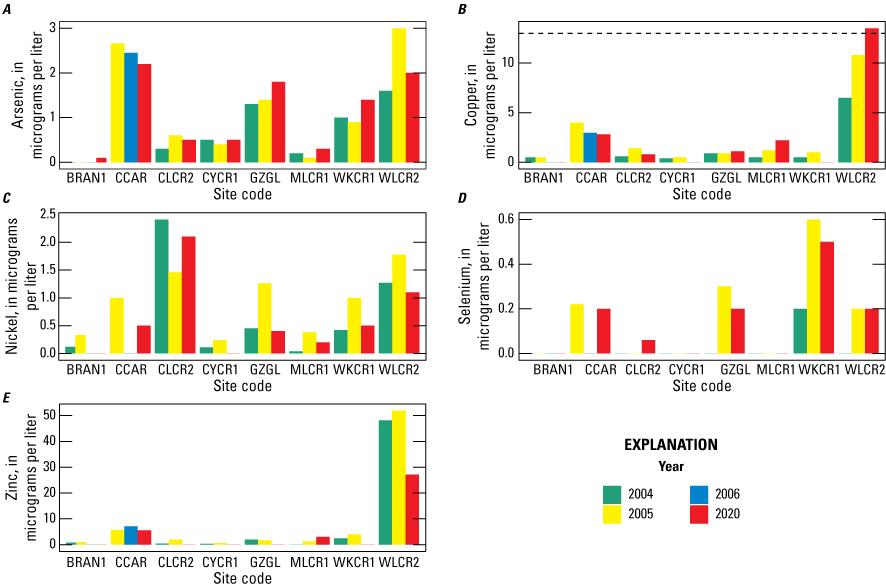
Concentrations of metals of biological concern measured in filtered water from sample locations within Whiskeytown National Recreation Area, Shasta County, California, 2004–20 (Wulff and others, 2023). The dashed line represents chronic toxicity for sculpin (Cottus) calculated for a water hardness of 100 milligrams per liter (mg/L; Besser and others, 2007), which is similar to the water hardness of 102 mg/L measured in Willow Creek near French Gulch (WLCR2; Wulff and others, 2023). Site code abbreviations: BRAN1, Brandy Creek near Whiskeytown; CCAR, Clear Creek above Carr Powerhouse near French Gulch; CLCR2, Clear Creek at Peltier Valley Road near Shasta; CYCR1, Crystal Creek near mouth near French Gulch; GZGL, Grizzly Gulch near Whiskeytown; MLCR1, Mill Creek near French Gulch; WKCR1, Whiskey Creek near Whiskeytown; WLCR2, Willow Creek near French Gulch.
With the exception of arsenic, concentrations of metals of concern were lowest in BRAN1 in 2020, post-Carr Fire. Concentrations of arsenic measured in BRAN1 were higher in 2020 than previously measured; however, concentrations of arsenic at BRAN1 were lower than concentrations measured at the other nine sites, and all samples were below EPA criteria (U.S. Environmental Protection Agency, 2022). Most data for metals of biological concern that were available for comparison with pre-Carr Fire data indicate variation among sites and years with no obvious patterns (fig. 3). Additional statistical analyses of available data could be completed to further explore the existence of potential patterns in the data that are not visually apparent.
Bed Sediment Chemistry
Of all sites sampled for bed sediment chemistry, WLCR2 had the highest average concentration of arsenic (28 μg/g), cadmium, (6.8 μg/g), copper (584 μg/g), and zinc (1,660 μg/g). Sample site CLCR2 had the highest concentrations of chromium (122 μg/g) and nickel (124 μg/g). The Crystal Creek near mouth near French Gulch sample site (CYCR1) had the highest concentration of lead (30.6 μg/g). The ranges of concentrations across all sites for metals are (1) arsenic (2.7–28 μg/g); (2) cadmium (0.3–6.8 μg/g); (3) chromium (58–122 μg/g); (4) copper (27–584 μg/g); (5) nickel (21–124 μg/g); (6) lead (16–30.6 μg/g); and (7) zinc (96–1,660 μg/g; table 3; Wulff and others, 2023).
Table 3.
Average concentrations of metals of biological concern detected in bed sediment samples from sites within Whiskeytown National Recreation Area, Shasta County, California, 2020 (Wulff and others, 2023).[Site code abbreviations: BRAN1, Brandy Creek near Whiskeytown; CCAR, Clear Creek above Carr Powerhouse near French Gulch; CLCR2, Clear Creek at Peltier Valley Road near Shasta; CCTMR, Clear Creek near French Gulch; CYCR1, Crystal Creek near mouth near French Gulch; GZGL, Grizzly Gulch near Whiskeytown; MLCR1, Mill Creek near French Gulch; WKCR1, Whiskey Creek near Whiskeytown; WLCR4, Willow Creek at Trinity Mountain Road near French Gulch; WLCR2, Willow Creek near French Gulch. Other abbreviations: µg/g, micrograms per gram; n, number of samples]
Benthic sediment results for metals of biological concern were compared with the consensus-based probable effect concentrations (PEC) from sediment-quality guidelines in MacDonald and others (2000; fig. 4). Measured concentrations from 2020 sampling indicated exceedances of these guidelines at one site for chromium (CLCR2), copper (WLCR2), and zinc (CLCR2), and three sites for nickel (CLCR2, WKCR1, WLCR2). Data collected in 2004–05 indicated exceedances for arsenic, cadmium, copper, and zinc (fig. 4). Arsenic, cadmium, copper, lead, and zinc concentrations varied among sites and years, with no obvious pre- versus post-fire patterns; however, concentrations of chromium measured in 2020 were higher than previous years at all sites, and concentrations of nickel measured in 2020 was higher in seven out of eight sites. The higher concentrations of chromium and nickel in bed sediment samples could be the result of post-fire sediment mobilization, and this finding could be especially relevant for watersheds with historical mining activity (Abraham and others, 2017).
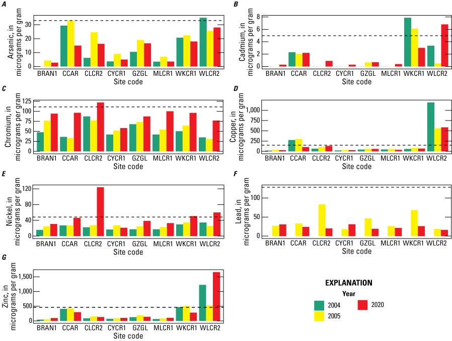
Average concentrations of metals of biological concern measured in bed sediment samples from sample locations in Whiskeytown National Recreation Area, Shasta County, California, 2004–20 (Wulff and others, 2023). The dashed line represents the consensus-based probable effect concentration (PEC) from sediment-quality guidelines in MacDonald and others (2000). Site code abbreviations: BRAN1, Brandy Creek near Whiskeytown; CCAR, Clear Creek above Carr Powerhouse near French Gulch; CLCR2, Clear Creek at Peltier Valley Road near Shasta; CYCR1, Crystal Creek near mouth near French Gulch; GZGL, Grizzly Gulch near Whiskeytown; MLCR1, Mill Creek near French Gulch; WKCR1, Whiskey Creek near Whiskeytown; WLCR2, Willow Creek near French Gulch.
Macroinvertebrate Samples
Benthic macroinvertebrate metrics that are part of the Northern California Index of Biotic Integrity (Rehn and others, 2005) are in table 4. Percentage of Ephemeroptera (mayflies), Plecoptera (stoneflies), and Trichoptera (caddisflies), known as EPT taxa, was highest (69 percent) at WLCR2. Percentage of Coleoptera (beetles) taxa was highest (19 percent) at CCTMR. Sample site CCAR had the highest percentage of Diptera taxa (61 percent), and CLCR2 had the highest percentage of non-insect taxa in samples (3 percent). The ranges of each macroinvertebrate metric were (1) EPT taxa (27–69 percent), (2) Coleoptera taxa (1–19 percent), (3) Diptera taxa (6–61 percent), and (4) non-insect taxa (0–3 percent).
Table 4.
Selected macroinvertebrate metrics from the Northern California Index of Biotic Integrity (Rehn and others, 2005) for macroinvertebrate samples collected from stream sites in Whiskeytown Recreation Area, Shasta County, California, 2020 (Wulff and others, 2023).[Site code abbreviations: BRAN1, Brandy Creek near Whiskeytown; CCAR, Clear Creek above Carr Powerhouse near French Gulch; CLCR2, Clear Creek at Peltier Valley Road near Shasta; CCTMR, Clear Creek near French Gulch; CYCR1, Crystal Creek near mouth near French Gulch; GZGL, Grizzly Gulch near Whiskeytown; MLCR1, Mill Creek near French Gulch; WKCR1, Whiskey Creek near Whiskeytown; WLCR4, Willow Creek at Trinity Mountain Road near French Gulch; WLCR2, Willow Creek near French Gulch. Other abbreviation: EPT; Ephemeroptera, Plecoptera, and Trichopetera]
Gerridae tissue samples had the highest average concentration of cadmium (12.47 µg/g), lead (0.13 µg/g), and zinc (333.35 µg/g) in WKCR1 (table 5). All measured chromium concentrations were below reporting limits (<1.2 µg/g). Sample site CLCR2 had the highest average concentrations of arsenic (0.46 µg/g) and nickel (0.63 µg/g). The ranges of concentrations averaged by site for metals are (1) arsenic (0.12–0.46 μg/g); (2) cadmium (1.57–12.47 μg/g); (3) chromium (<1.2 μg/g); (4) copper (30.97–57.80 μg/g); (5) nickel (0.31–0.63 μg/g); (6) lead (0.05–0.13 μg/g); and (7) zinc (205.0–333.35 μg/g; table 5).
Table 5.
Concentrations of metals in invertebrate Gerridae composite tissue samples averaged by site within Whiskeytown National Recreation Area, Shasta County, California, 2020 (Wulff and others, 2023).[Site code abbreviations: BRAN1, Brandy Creek near Whiskeytown; CCAR, Clear Creek above Carr Powerhouse near French Gulch; CCTMR, Clear Creek near French Gulch; CLCR2, Clear Creek at Peltier Valley Road near Shasta; CYCR1, Crystal Creek near mouth near French Gulch; GZGL, Grizzly Gulch near Whiskeytown; MLCR1, Mill Creek near French Gulch; WKCR1, Whiskey Creek near Whiskeytown; WLCR2, Willow Creek near French Gulch; WLCR4, Willow Creek at Trinity Mountain Road near French Gulch. Other abbreviations: µg/g, micrograms per gram; n, number of samples; AVE, average; <, values less than reporting limit; SD, standard deviation; —, no value]
Fish and Amphibian Samples
Average concentrations of arsenic (0.49 µg/g) and lead (0.21 µg/g) were highest at GZGL. Sample site WLCR2 had the highest average concentrations of cadmium (0.41 µg/g), copper (8.56 µg/g), and zinc (164.44 µg/g). Sample site WKCR1 had the highest average concentration of nickel (1.43 µg/g). Average chromium concentration was highest (1.7 µg/g) at CCAR, but 95 percent of chromium samples were below reporting limits (<1.1 µg/g). The range of concentrations averaged by site for metals are (1) arsenic (0.13–0.49 μg/g); (2) cadmium (0.02–0.41 μg/g); (3) chromium (<1.1–1.7 μg/g); (4) copper (2.11–8.56 μg/g); (5) nickel (<0.03–1.43 μg/g); (6) lead (0.06–0.21 μg/g); and (7) zinc (67.44–164.44 μg/g; table 6).
Table 6.
Concentrations of metals in riffle sculpin (Cottus gulosus) composite tissue samples averaged by site within Whiskeytown National Recreation Area, Shasta County, California, 2020 (Wulff and others, 2023).[Site code abbreviations: BRAN1, Brandy Creek near Whiskeytown; CCAR, Clear Creek above Carr Powerhouse near French Gulch; CLCR2, Clear Creek at Peltier Valley Road near Shasta; CCTMR, Clear Creek near French Gulch; CYCR1, Crystal Creek near mouth near French Gulch; GZGL, Grizzly Gulch near Whiskeytown; MLCR1, Mill Creek near French Gulch; WKCR1, Whiskey Creek near Whiskeytown; WLCR4, Willow Creek at Trinity Mountain Road near French Gulch; WLCR2, Willow Creek near French Gulch. Other abbreviations: g, grams; µg/g, micrograms per gram; n, number of samples; AVE, average; <, values less than reporting limit; SD, standard deviation; —, no value]
A total of seven fish species and one amphibian species were collected during the study (table 7). Riffle sculpin was the most abundant species and was collected at most sites. Of the eight fish taxa collected, only two were non-native species: Bluegill (Lepomis macrochirus) and Spotted Bass (Micropterus punctulatus). Only Spotted Bass was documented in more than one sample. Pacific Giant Salamander were only captured at BRAN1.
Table 7.
Common and scientific name count summary by site for fish and amphibians collected by backpack electroshock sampling at sites within Whiskeytown Recreation Area, Shasta County, California, 2020 (Wulff and others, 2023).[BRAN1, Brandy Creek near Whiskeytown; CCAR, Clear Creek above Carr Powerhouse near French Gulch; CLCR2, Clear Creek at Peltier Valley Road near Shasta; CCTMR, Clear Creek near French Gulch; CYCR1, Crystal Creek near mouth near French Gulch; GZGL, Grizzly Gulch near Whiskeytown; MLCR1, Mill Creek near French Gulch; WKCR1, Whiskey Creek near Whiskeytown; WLCR2, Willow Creek near French Gulch]
Post-Carr Fire concentrations of metals in fish and invertebrate samples were compared with pre-Carr Fire concentrations at two sites, BRAN1 and CCAR. These two sites were the only sites where data were collected in pre- and post-Carr Fire years. Concentrations of metals of biological concern, including arsenic, chromium, cadmium, copper, lead, nickel, and zinc, generally varied among sites and years without a specific pattern in relation to the Carr Fire (figs. 5, 6). Average zinc concentrations in composite invertebrate samples were slightly higher in 2020 than in 2004–05 at BRAN1 and CCAR (fig. 5). Average lead concentrations in fish tissue were higher at both sites in 2020 than in 2004–05. Arsenic concentrations were lowest in 2020 for invertebrate and fish tissues. Chromium and cadmium concentrations in fish tissue were lower in 2020 than in previous years (fig. 6).
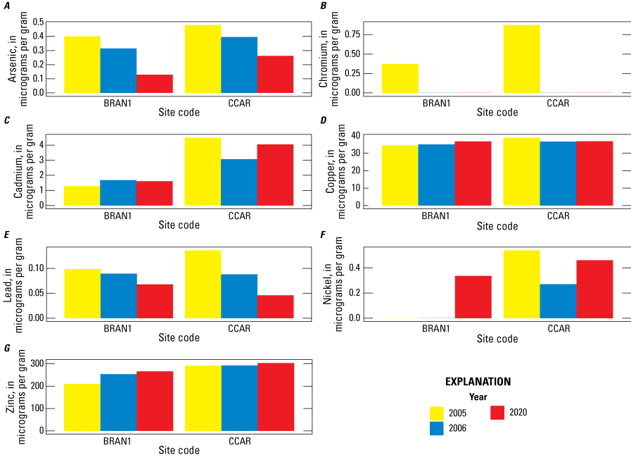
Concentrations of metals of biological concern in invertebrate Gerridae composite samples averaged by site within Whiskeytown National Recreation Area, Shasta County, California, 2004–20 (Wulff and others, 2023). Site code abbreviations: BRAN1, Brandy Creek near Whiskeytown; CCAR, Clear Creek above Carr Powerhouse near French Gulch.
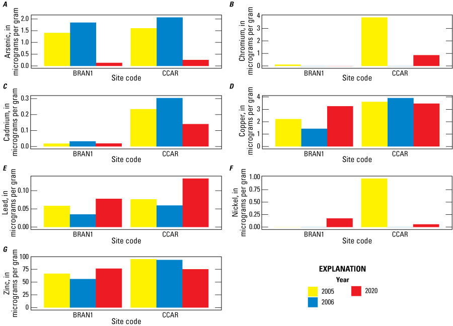
Concentrations of metals of biological concern in riffle sculpin (Cottus gulosus) composite samples averaged by site within Whiskeytown National Recreation Area, Shasta County, California, 2004–20 (Wulff and others, 2023). Site code abbreviations: BRAN1, Brandy Creek near Whiskeytown; CCAR, Clear Creek above Carr Powerhouse near French Gulch.
In general, review of 2020 post-Carr Fire data compared to previous years demonstrated that concentrations of metals of biological concern varied substantially among sites and years, with few patterns in the data. Concentrations of chromium and nickel in bed sediment increased after the Carr Fire, but most other metals in sediment and water either did not change or demonstrated high variation among sites and years. Concentrations of lead in riffle sculpin tissues were higher post-Carr Fire compared to pre-Carr Fire, and arsenic concentrations were lower in invertebrate and fish tissues in post-Carr Fire samples compared to pre-Carr Fire samples.
Stream-Habitat Characterization
Habitat characteristics, including reach length, elevation, discharge, percentage riffle/run/pool, mean wetted width, mean open canopy, mean riparian canopy closure, mean depth, mean water velocity, and dominant substrate, were assessed for each site (table 8). Sample sites CLCR2 (96 percent) and WLCR2 (89 percent) had the highest percentage of riparian canopy closure, or riparian shade, of all the sites. Clear Creek had the highest average width, highest mean discharge, and lowest gradient sampled. Sample site CLCR2, downstream from Whiskeytown Lake, is affected by operations of Whiskeytown Dam, and has the highest recorded discharge of all the sites. Substrate size and heterogeneity are summarized by site (figs. 7, 8).
Table 8.
Sample reach lengths, elevations, and selected habitat characteristics of sites sampled within Whiskeytown Recreation Area, Shasta County, California, 2020 (Wulff and others, 2023).[Site code abbreviations: BRAN1, Brandy Creek near Whiskeytown; CCAR, Clear Creek above Carr Powerhouse near French Gulch; CLCR2, Clear Creek at Peltier Valley Road near Shasta; CCTMR, Clear Creek near French Gulch; CYCR1, Crystal Creek near mouth near French Gulch; GZGL, Grizzly Gulch near Whiskeytown; MLCR1, Mill Creek near French Gulch; WKCR1, Whiskey Creek near Whiskeytown; WLCR4, Willow Creek at Trinity Mountain Road near French Gulch; WLCR2, Willow Creek near French Gulch. Other abbreviations: m, meter; m3/s, cubic meters per second; CV, coefficient of variation; %, percentage, NA, no information available; max, maximum; m/s, meters per second; >, greater than; mm, millimeter]
Best representation of the overall substrate category. Substrate categories are as follows: smooth bedrock/concrete/hardpan; silt; sand (>0.063–2 mm); fine gravel, fine/medium gravel (>2–16 mm); coarse gravel (>16–32 mm); very coarse gravel (>32–64 mm); small cobble (>64–128 mm); large cobble (>128–256 mm); small boulder (>256–512 mm); large boulder (>512 mm; Fitzpatrick and others, 1998).
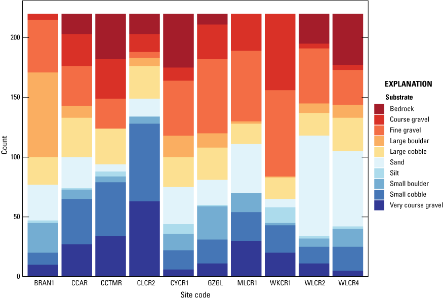
Substrate size characterization summarized by site within Whiskeytown National Recreation Area, California, 2020 (Wulff and others, 2023). There were 220 total particles (n) measured at each site. Substrate categories are as follows: smooth bedrock/concrete/hardpan; silt; sand (greater than [>] 0.063–2 millimeters [mm]); fine gravel, fine/medium gravel (>2–16 mm); coarse gravel (>16–32 mm); very coarse gravel (>32–64 mm); small cobble (>64–128 mm); large cobble (>128–256 mm); small boulder (>256–512 mm); large boulder (>512 mm; Fitzpatrick and others, 1998). Site code abbreviations: BRAN1, Brandy Creek near Whiskeytown; CCAR, Clear Creek above Carr Powerhouse near French Gulch; CCTMR, Clear Creek near French Gulch; CLCR2, Clear Creek at Peltier Valley Road near Shasta; CYCR1, Crystal Creek near mouth near French Gulch; GZGL, Grizzly Gulch near Whiskeytown; MLCR1, Mill Creek near French Gulch; WKCR1, Whiskey Creek near Whiskeytown; WLCR2, Willow Creek near French Gulch; WLCR4, Willow Creek at Trinity Mountain Road near French Gulch.
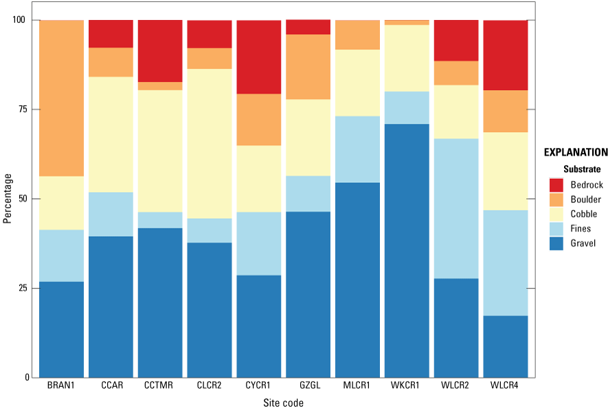
Percentage substrate size characterization summarized by site within Whiskeytown National Recreation Area, California, 2020 (Wulff and others, 2023). Substrate categories are as follows: smooth bedrock/concrete/hardpan; silt; sand (greater than [>] 0.063–2 millimeters [mm]); fine gravel, fine/medium gravel (>2–16 mm); coarse gravel (>16–32 mm); very coarse gravel (>32–64 mm); small cobble (>64–128 mm); large cobble (>128–256 mm); small boulder (>256–512 mm); large boulder (>512 mm); percentage bedrock; percentage fines, percentage silt + percentage sand; percentage gravel, percentage fine/medium gravel + percentage coarse gravel + percentage very coarse gravel; percentage cobble, percentage small cobble + percentage large cobble; percentage boulder, percentage small boulder + percentage large boulder (Fitzpatrick and others, 1998). Site code abbreviations: BRAN1, Brandy Creek near Whiskeytown; CCAR, Clear Creek above Carr Powerhouse near French Gulch; CCTMR, Clear Creek near French Gulch; CLCR2, Clear Creek at Peltier Valley Road near Shasta; CYCR1, Crystal Creek near mouth near French Gulch; GZGL, Grizzly Gulch near Whiskeytown; MLCR1, Mill Creek near French Gulch; WKCR1, Whiskey Creek near Whiskeytown; WLCR2, Willow Creek near French Gulch; WLCR4, Willow Creek at Trinity Mountain Road near French Gulch.
Stream-habitat and sediment-size characterization values either did not change substantially or demonstrated high variation among sites and years (figs. 9, 10). Fish and amphibian count data indicated that fewer total fish and amphibians were collected in 2020 than in 2005, but higher numbers of native Sacramento Sucker (Catostomus occidentalis) and Sacramento Pikeminnow (Ptychocheilus grandis) were collected in 2020 than in previous years (fig. 11). Sample site BRAN1 has been subjected to the least amount of historical mining disturbance and frequently had the lowest concentrations of metals of biological concern in water, sediment, and fish and invertebrate tissue samples.
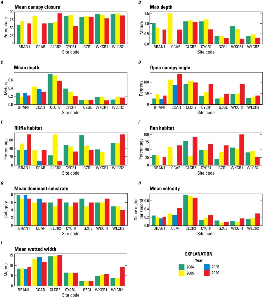
Selected stream-habitat characteristics of sites in Whiskeytown Recreation Area, Shasta County, California, 2004–20 (Wulff and others, 2023). Site code abbreviations: BRAN1, Brandy Creek near Whiskeytown; CCAR, Clear Creek above Carr Powerhouse near French Gulch; CLCR2, Clear Creek at Peltier Valley Road near Shasta; CYCR1, Crystal Creek near mouth near French Gulch; GZGL, Grizzly Gulch near Whiskeytown; WKCR1, Whiskey Creek near Whiskeytown; WLCR2, Willow Creek near French Gulch.
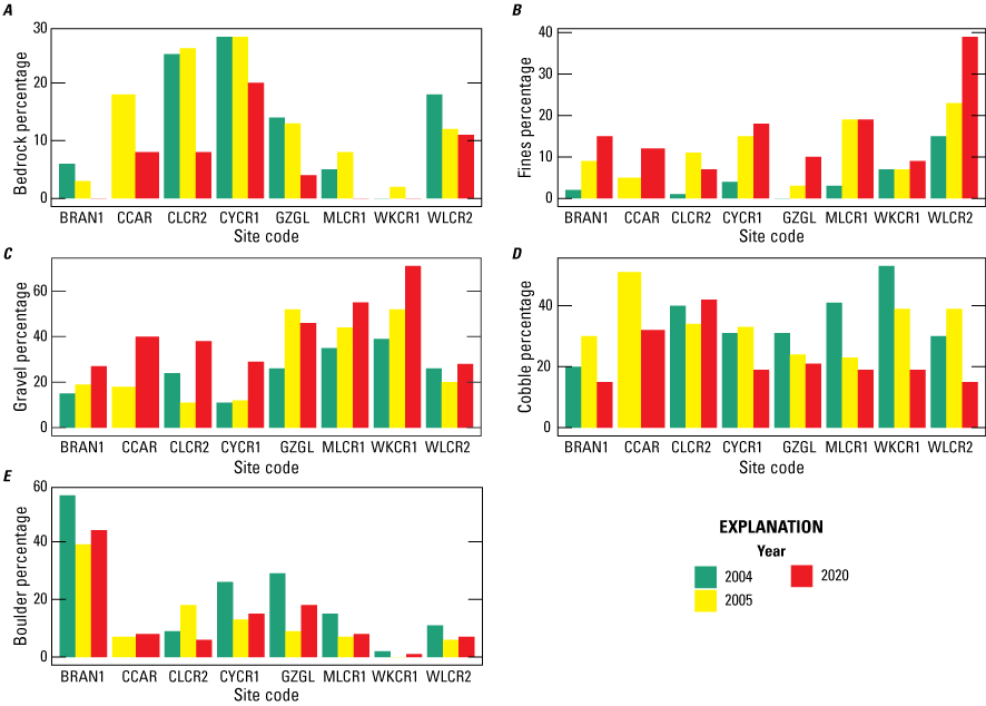
Substrate size characterization summarized by site within Whiskeytown National Recreation Area, California, 2004–20 (Wulff and others, 2023). There were 220 total particles (n) measured at each site. Site code abbreviations: BRAN1, Brandy Creek near Whiskeytown; CCAR, Clear Creek above Carr Powerhouse near French Gulch; CLCR2, Clear Creek at Peltier Valley Road near Shasta; CYCR1, Crystal Creek near mouth near French Gulch; GZGL, Grizzly Gulch near Whiskeytown; MLCR1, Mill Creek near French Gulch; WKCR1, Whiskey Creek near Whiskeytown; WLCR2, Willow Creek near French Gulch.
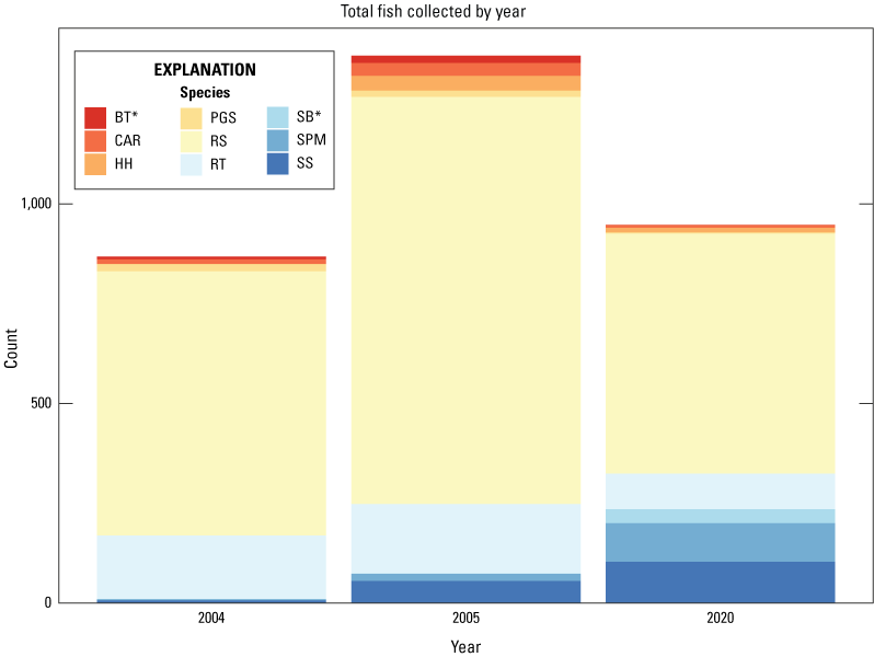
Count summary by year for fish and amphibians collected by backpack electroshock sampling in Whiskeytown Recreation Area, Shasta County, California, 2004–20 (Wulff and others, 2023). Abbreviations: BT, brook trout* (Salvelinus fontinalis); CAR, California Roach (Hesperoleucus symmetricus); HH, Hardhead (Mylopharodon conocephalus); PGS, Pacific Giant Salamander (Dicamptodon tenebrosus); RS, riffle sculpin (Cottus gulosus); RT, Rainbow Trout (Oncorhynchus mykiss); SB, Spotted Bass* (Micropterus punctulatus); SPM, Sacramento Pikeminnow (Ptychocheilus grandis); SS, Sacramento Sucker (Catostomus occidentalis); *, non-native.
Summary and Conclusions
Overall results from 2020 sampling indicate that the tributaries to Whiskeytown Lake within the Whiskeytown National Recreation Area had varying concentrations of metals in water, sediment, and animal tissues. Sediment samples from three sites (Willow Creek near French Gulch [WLCR2], Whiskey Creek near Whiskeytown [WKCR1], and Clear Creek at Peltier Valley Road near Shasta [CLCR2]) had concentrations of metals (cadmium, chromium, copper, nickel, and zinc) that exceeded sediment toxicity thresholds. Concentrations of copper in water and tissue samples are also noteworthy because these results may indicate water quality and aquatic ecosystem health impairment.
Joint studies by the U.S. Geological Survey and the National Park Service in 2002–06 indicated that the tributaries to Whiskeytown Lake were in fair to very good biological condition, with diverse, largely native populations of fish, benthic macroinvertebrates, and algae (Wulff and others, 2012; Hothem and others, 2015). Targeted post-fire sampling of sites affected by the 2004 French Fire in 2005–06 indicated that the aquatic communities were resilient to the local effects of fire, presumably due to migration of organisms into recently burned reaches (Hothem and others, 2008). These results might indicate that the ecosystems at Whiskeytown National Recreation Area are resilient to disturbance regimes; however, the effects of the French Fire were relatively localized compared to the Carr Fire and had only a few areas of high-severity fire near stream margins (fig. 1).
The combined histories of mining in the watershed and frequent wildfires could potentially increase the risk for metal contamination throughout the aquatic system at Whiskeytown National Recreation Area. Continued monitoring for multilevel trophic effects of contaminants would continue to provide information needed to describe the overall health of Whiskeytown National Recreation Area. The results presented in this report will provide managers at Whiskeytown National Recreation Area with information to help understand the effects of wildfires on water quality and aquatic ecosystem health. This information can also be used to inform strategies to help mitigate metal contamination and sedimentation in the watershed. Results can also be used to guide stream restoration activities for streams demonstrating substantial changes in response to the Carr Fire of 2018. This report provides updated baseline information that could inform future studies, and results presented in this report can be used to guide response planning following future wildfires at Whiskeytown National Recreation Area.
References Cited
Abraham, J., Dowling, K., and Florentine, S., 2017, The unquantified risk of post-fire metal concentration in soil—A review: Water, Air, & Soil Pollution, v. 228, article 175, 33 p., accessed February 23, 2022, at https://doi.org/10.1007/s11270-017-3338-0.
Axtmann, E.V., Cain, D.J., and Luoma, S.N., 1997, Effect of tributary inflows on the distribution of trace metals in fine-grained bed sediments and benthic insects of the Clark Fork River, Montana: Environmental Science & Technology, v. 31, no. 3, p. 750–758. [Available at https://doi.org/10.1021/es960417y.]
Besser, J.M., Mebane, C.A., Mount, D.R., Ivey, C.D., Kunz, J.L., Greer, I.E., May, T.W., and Ingersoll, C.G., 2007, Sensitivity of mottled sculpins (Cottus bairdii) and rainbow trout (Onchorhynchus mykiss) to acute and chronic toxicity of cadmium, copper, and zinc: Environmental Toxicology and Chemistry, v. 26, no. 8, p. 1657–1665. [Available at https://doi.org/10.1897/06-571R.1.]
Bixby, R.J., Cooper, S.D., Gresswell, R.E., Brown, L.E., Dahm, C.N., and Dwire, K.A., 2015, Fire effects on aquatic ecosystems—An assessment of the current state of the science: Freshwater Science, v. 34, no. 4, p. 1340–1350. [Available at https://doi.org/10.1086/684073.]
Bureau of Reclamation, 2023, Central Valley Project: Bureau of Reclamation web page, accessed January 3, 2023, at https://www.usbr.gov/mp/cvp/.
Burned Area Emergency Response Team, 2018, Carr Fire 2018 burned area emergency response plan: Redding, Calif., Redding Field Office, Bureau of Land Management, Whiskeytown National Recreation Area, National Park Service, Shasta-Trinity National Forest, 402 p., accessed February 23, 2022, at https://www.nps.gov/whis/upload/WHIS-Carr-BAER-Redacted-20181004-1.pdf.
Burton, C.A., Hoefen, T.M., Plumlee, G.S., Baumberger, K.L., Backlin, A.R., Gallegos, E., and Fisher, R.N., 2016, Trace elements in stormflow, ash, and burned soil following the 2009 Station Fire in southern California: PLoS One, v. 11, no. 5, 26 p. [Available at https://doi.org/10.1371/journal.pone.0153372.]
Bury, R.B., and Pearl, C.A., 1999, Klamath-Siskiyou herpetofauna—Biogeographic patterns and conservation strategies: Natural Areas Journal, v. 19, no. 4, p. 341–350. [Available at https://pubs.usgs.gov/publication/1015999.]
California Geological Survey, 2002, California geomorphic provinces: California Geological Survey Note 36, accessed February 23, 2022, at https://www.conservation.ca.gov/cgs/documents/publications/cgs-notes/CGS-Note-36.pdf.
DellaSala, D.A., Reid, S.B., Frest, T.J., Strittholt, J.R., and Olson, D.M., 1999, A global perspective on the biodiversity of the Klamath-Siskiyou ecoregion: Natural Areas Journal, v. 19, no. 4, p. 300–319. [Available at https://www.researchgate.net/publication/291850761_A_global_perspective_on_the_biodiversity_of_the_Klamath-Siskiyou_Ecoregion.]
East, A.E., Logan, J.B., Dartnell, P., Lieber-Kotz, O., Cavagnaro, D.B., McCoy, S.W., and Lindsay, D.N., 2021, Watershed sediment yield following the 2018 Carr Fire, Whiskeytown National Recreation Area, northern California: Earth and Space Science, v. 8, no. 9, 24 p. [Available at https://doi.org/10.1029/2021EA001828.]
Fishman, M.J., ed., 1993, Methods of analysis by the U.S. Geological Survey National Water Quality Laboratory—Determination of inorganic and organic constituents in water and fluvial sediments: U.S. Geological Survey Open-File Report 93–125, 217 p. [Available at https://doi.org/10.3133/ofr93125.]
Fishman, M.J., and Friedman, L.C., 1989, Methods for determination of inorganic substances in water and fluvial sediments: U.S. Geological Survey Techniques of Water Resources Investigations, book 5, chap. A1, 545 p. [Available at https://doi.org/10.3133/twri05A1.]
Fitzpatrick, F.A., Waite, I.R., D’Arconte, P.J., Meador, M.R., Maupin, M.A., and Gurtz, M.E., 1998, Revised methods for characterizing stream habitat in the National Water-Quality Assessment Program: U.S. Geological Survey Water-Resources Investigations Report 98–4052, 67 p. [Available at https://doi.org/10.3133/wri984052.]
Garbarino, J.R., 1999, Methods of analysis by the U.S. Geological Survey National Water Quality Laboratory—Determination of dissolved arsenic, boron, lithium, selenium, strontium, thallium, and vanadium using inductively coupled plasma-mass spectrometry: U.S. Geological Survey Open-File Report 99–093, 31 p. [Available at https://doi.org/10.3133/ofr9993.]
Garbarino, J.R., Kanagy, L.K., and Cree, M.E., 2006, Chapter 1. Determination of elements in natural water, biota, sediment and soil samples using collision/reaction cell inductively coupled plasma-mass spectrometry: U.S. Geological Survey Techniques and Methods, book 5, chap. B1, 87 p. [Available at https://doi.org/10.3133/tm5B1.]
Garbarino, J.R., and Struzeski, T.M., 1998, Methods of analysis by the U.S. Geological Survey National Water Quality Laboratory—Determination of elements in whole-water digests using inductively coupled plasma-optical emission spectrometry and inductively coupled plasma-mass spectrometry: U.S. Geological Survey Open-File Report 98–165, 101 p. [Available at https://doi.org/10.3133/ofr98165.]
Hoffman, G.L., Fishman, M.J., and Garbarino, J.R., 1996, Methods of analysis by the U.S. Geological Survey National Water Quality Laboratory-in-bottle acid digestion of whole-water samples: U.S. Geological Survey Open-File Report 96–225, 28 p. [Available at https://doi.org/10.3133/ofr96225.]
Hothem, R.L., May, J.T., Brown, L.R., Moore, J., Gibson, J.K., and Rasmussen, B., 2008, Mobilization and bioaccumulation of metals and trace elements in aquatic biota from the upper Clear Creek watershed and Whiskeytown National Recreation Area, California, following the French Fire: U.S. Geological Survey data summary, 87 p.
Hothem, R.L., May, J.T., Gibson, J.K., and Brussee, B.E., 2015, Concentrations of metals and trace elements in aquatic biota associated with abandoned mine lands in the Whiskeytown National Recreation Area and nearby Clear Creek watershed, Shasta County, northwestern California, 2002–2003: U.S. Geological Survey Open-File Report 2015–1077, 64 p. [Available at https://doi.org/10.3133/ofr20151077.]
Jones, M.W., Abatzoglou, J.T., Veraverbeke, S., Andela, N., Lasslop, G., Forkel, M., Smith, A.J., Burton, C., Betts, R.A., van der Werf, G.R., Sitch, S., Canadell, J.G., Santín, C., Kolden, C., Doerr, S.H., and Le Quéré, C., 2022, Global and regional trends and drivers of fire under climate change: Reviews of Geophysics, v. 60, no. 3, 76 p. [Available at https://doi.org/10.1029/2020RG000726.]
MacDonald, D.D., Ingersoll, C.G., and Berger, T.A., 2000, Development and evaluation of consensus-based sediment quality guidelines for freshwater ecosystems: Archives of Environmental Contamination and Toxicology, v. 39, p. 20–31. [Available at https://doi.org/10.1007/s002440010075.]
May, J.T., Hothem, R.L., Bauer, M.L., and Brown, L.R., 2012, Concentrations of mercury and other metals in black bass (Micropterus spp.) from Whiskeytown Lake, Shasta County, California, 2005: U.S. Geological Survey Open-File Report 2011–1297, 16 p. [Available at https://doi.org/10.3133/ofr20111297.]
May, J.T., Nowell, L.H., Coles, J.F., Button, D.T., Bell, A.H., Qi, S.L., and Van Metre, P.C., 2020, Design and methods of the California stream quality assessment, 2017: U.S. Geological Survey Open-File Report 2020–1023, 88 p., accessed February 23, 2022, at https://doi.org/10.3133/ofr20201023.
McCormick, S.A., Peterson, P.L., and Ringold, T., Magee, and Cappaert, M.R., 2006, Environmental Monitoring and Assessment Program—Surface Waters Western Pilot Study—Field Operations Manual for Wadeable Streams: Washington, D.C., U.S. Environmental Protection Agency, Office of Research and Development, 242 p.
Moore, J.N., and Hughes, D., 2003, Trace metals in sediments of a mine impacted river basin—Clear Creek, California Project: Missoula, Mont., University of Montana, Final Report submitted to the National Park Service, 136 p. [Available at https://files.cfc.umt.edu/cesu/NPS/UMT/2003/Moore_WhiskeytownReport2003.pdf.]
Moulton, S.R., II, Carter, J.L., Grotheer, S.A., Cuffney, T.F., and Short, T.M., 2000, Methods of analysis by the U.S. Geological Survey National Water Quality Laboratory—Processing, taxonomy, and quality control of benthic macroinvertebrate samples: U.S. Geological Survey Open-File Report 2000–212, 49 p. [Available at https://doi.org/10.3133/ofr00212.]
Moulton, S.R., II, Kennen, J.G., Goldstein, R.M., and Hambrook, J.A., 2002, Revised protocols for sampling algal, invertebrate, and fish communities as part of National Water-Quality Assessment Program: U.S. Geological Survey Open-File Report 2002–150, 75 p. [Available at https://doi.org/10.3133/ofr2002150.]
Murphy, S.F., Writer, J.H., McCleskey, R.B., and Martin, D.A., 2015, The role of precipitation type, intensity, and spatial distribution in source water quality after wildfire: Environmental Research Letters, v. 10, no. 8, 13 p. [Available at https://doi.org/10.1088/1748-9326/10/8/084007.]
National Park Service, 2021, The Carr Fire of 2018 and ongoing recovery: National Park Service web page, accessed March 30, 2021, at https://www.nps.gov/whis/learn/news/carrfire.htm.
Patton, C.J., and Kryskalla, J.R., 2003, Methods of analysis by the U.S. Geological Survey National Water Quality Laboratory—Evaluation of alkaline persulfate digestion as an alternative to Kjeldahl digestion for determination of total and dissolved nitrogen and phosphorus in water: U.S. Geological Survey Water-Resources Investigations Report 2003–4174, 33 p. [Available at https://doi.org/10.3133/wri034174.]
Rehn, A.C., Ode, P.R., and May, J.T., 2005, Development of a benthic index of biotic integrity (B-IBI) for wadeable streams in Northern Coastal California and its application to Regional 305(b) assessment: Sacramento, Calif., California Surface Water Ambient Monitoring Program, 39 p., accessed February 23, 2022, at https://www.researchgate.net/publication/262911879_Development_of_a_Benthic_Index_of_Biotic_Integrity_B-IBI_for_Wadeable_Streams_in_Northern_Coastal_C alifornia_and_its_Application_to_Regional_305b_Assessment.
Richards, A.B., and Rodgers, D.C., 2011, List of freshwater macroinvertebrate taxa from California and adjacent states including standard taxonomic effort levels—Appendix I: Chico, Calif., Southwest Association of Freshwater Invertebrate Taxonomists, accessed February 23, 2022, at https://safit.org/wp-content/uploads/2024/01/STE_1_March_2011_7MB.pdf.
Roth, D.A., Johnson, M.O., McCleskey, R.B., Riskin, M.L., and Bliznik, P.A., 2022, Evaluation of preservation techniques for trace metals and major cations for surface waters collected from the U.S. Geological Survey’s National Water Quality Network Sites: U.S. Geological Survey data release. [Available at https://doi.org/10.5066/P9SMPZ3M.]
Scholten, R.C., Jandt, R., Miller, E.A., Rogers, B.M., and Veraverbeke, S., 2021, Overwintering fires in boreal forests: Nature, v. 593, p. 399–404. [Available at https://doi.org/10.1038/s41586-021-03437-y.]
Shelton, L.R., 1994, Field guide for collecting and processing stream-water samples for the National Water-Quality Assessment Program: U.S. Geological Survey Open-File Report 94–455, 42 p. [Available at https://doi.org/10.3133/ofr94455.]
Shelton, L.R., and Capel, P.D., 1994, Guidelines for collecting and processing samples of stream bed sediment for analysis of trace elements and organic contaminants for the National Water-Quality Assessment Program: U.S. Geological Survey Open-File Report 94–458, 20 p. [Available at https://doi.org/10.3133/ofr94458.]
Tetra Tech, Inc., 1998, Upper Clear Creek watershed analysis: San Francisco, Calif., Prepared for Western Shasta Resource Conservation District, Tetra Tech, Inc., 190 p., accessed February 23, 2022, at https://www.fs.usda.gov/Internet/FSE_DOCUMENTS/stelprdb5400003.pdf.
Thomson, R.C., Wright, A.N., and Shaffer, H.B., 2016, California amphibian and reptile species of special concern: Oakland, Calif., University of California Press, accessed February 23, 2022, at https://wildlife.ca.gov/Conservation/SSC/Amphibians-Reptiles.
U.S. Environmental Protection Agency, 2022, National recommended water quality criteria—Aquatic life criteria table: U.S. Environmental Protection Agency web page, accessed February 23, 2022, at https://www.epa.gov/wqc/national-recommended-water-quality-criteria-aquatic-life-criteria-table.
U.S. Geological Survey, 2016, USGS water data for the Nation: U.S. Geological Survey National Water Information System: U.S. Geological Survey web page, accessed August 1, 2023, at https://doi.org/10.5066/F7P55KJN.
U.S. Geological Survey, [variously dated], Processing of water samples—USGS field manual for the collection of water-quality data, version 2.2, in National Field Manual for the Collection of Water-Quality Data: U.S. Geological Survey Techniques of Water-Resources Investigations, book 9, chap. A5, accessed October 24, 2019, at https://doi.org/10.3133/twri09A5.
U.S. Geological Survey Burn Severity Portal, 2022, Monitoring trends in burn severity: U.S. Department of Agriculture, U.S. Geological Survey, accessed January 10, 2022, at https://burnseverity.cr.usgs.gov/products/mtbs.
van Mantgem, P.J., Nesmith, J.C.B., Keifer, M., Knapp, E.E., Flint, A., and Flint, L., 2013, Climatic stress increases forest fire severity across the western United States: Ecology Letters, v. 16, no. 9, p. 1151–1156. [Available at https://doi.org/10.1111/ele.12151.]
Wolman, M.G., 1954, A method for sampling coarse river-bed material: Eos, Transactions, American Geophysical Union, v. 35, no. 6, p. 951–956. [Available at https://doi.org/10.1029/TR035i006p00951.]
Woodard, M.E., Slusark, J., and Ode, P.R., 2012, Standard operating procedures for laboratory processing and identification of benthic macroinvertebrates in California: California State Water Resources Control Board Surface Water Ambient Monitoring Program (SWAMP) Bioassessment SOP 003, accessed February 23, 2022, at https://www.waterboards.ca.gov/water_issues/programs/swamp/docs/bmi_lab_sop_final.pdf.
Wulff, M.L., Brown, L.R., and Violette, V.L., 2023, Post Carr Fire bioassessment data, Whiskeytown National Recreation Area, Shasta County, California, 2020: U.S. Geological Survey data release. [Available at https://doi.org/10.5066/P90WGKWI.]
Wulff, M.L., May, J.T., and Brown, L.R., 2012, Upper Clear Creek watershed aquatic chemistry and biota surveys, 2004–05, Whiskeytown National Recreation Area, Shasta County, California: U.S. Geological Survey Open-File Report 2012–1173, 8 p. [Available at https://doi.org/10.3133/ofr20121173.]
Yoshiyama, R.M., Fisher, F.W., and Moyle, P.B., 1998, Historical abundance and decline of chinook salmon in the Central Valley region of California: North American Journal of Fisheries Management, v. 18, no. 3, p. 487–521. [Available at https://doi.org/10.1577/1548-8675(1998)018<0487:HAADOC>2.0.CO;2.]
Conversion Factors
International System of Units to U.S. customary units
Supplemental Information
Concentrations of chemical constituents in water are given in either milligrams per liter (mg/L) or micrograms per liter (µg/L).
Metals of biological concern were measured in micrograms per gram (µg/g).
Abbreviations
BRAN1
Brandy Creek near Whiskeytown sample site
CCAR
Clear Creek above Carr Powerhouse near French Gulch sample site
CCTMR
Clear Creek near French Gulch sample site
CLCR2
Clear Creek at Peltier Valley Road near Shasta sample site
CYCR1
Crystal Creek near mouth near French Gulch sample site
EPA
U.S. Environmental Protection Agency
GZGL
Grizzly Gulch near Whiskeytown sample site
MLCR1
Mill Creek near French Gulch sample site
NAWQA
National Water Quality Assessment Program
USGS
U.S. Geological Survey
WKCR1
Whiskey Creek near Whiskeytown sample site
WLCR2
Willow Creek near French Gulch sample site
WLCR4
Willow Creek at Trinity Mountain Road near French Gulch sample site
For more information concerning the research in this report, contact the
Director, California Water Science Center
U.S. Geological Survey
6000 J Street, Placer Hall
Sacramento, California 95819
https://www.usgs.gov/centers/california-water-science-center
Publishing support provided by the Science Publishing Network,
Sacramento Publishing Service Center
Disclaimers
Any use of trade, firm, or product names is for descriptive purposes only and does not imply endorsement by the U.S. Government.
Although this information product, for the most part, is in the public domain, it also may contain copyrighted materials as noted in the text. Permission to reproduce copyrighted items must be secured from the copyright owner.
Suggested Citation
Wulff, M.L., Brown, L.R., and Violette, V.L., 2024, Post Carr Fire bioassessment data report, Whiskeytown National Recreation Area, Shasta County, California: U.S. Geological Survey Data Report 1201, 26 p., https://doi.org/10.3133/dr1201.
ISSN: 2771-9448 (online)
Study Area
| Publication type | Report |
|---|---|
| Publication Subtype | USGS Numbered Series |
| Title | Post Carr Fire bioassessment data report, Whiskeytown National Recreation Area, Shasta County, California |
| Series title | Data Report |
| Series number | 1201 |
| DOI | 10.3133/dr1201 |
| Publication Date | November 12, 2024 |
| Year Published | 2024 |
| Language | English |
| Publisher | U.S. Geological Survey |
| Publisher location | Reston, VA |
| Contributing office(s) | California Water Science Center |
| Description | Report: viii, 26 p.; Data Release |
| Country | United States |
| State | California |
| County | Shasta County |
| Other Geospatial | Whiskeytown National Recreation Area |
| Online Only (Y/N) | Y |


