
New Mexico and Landsat
Links
- Document: Report (23.7 MB pdf) , HTML , XML
- Version History: Version History (2.61 kB txt)
- NGMDB Index Page: National Geologic Map Database Index Page (html)
- Download citation as: RIS | Dublin Core
Abstract
Landscapes of rose-colored deserts, broken mesas, and high, snow-capped peaks give New Mexico its reputation as the “Land of Enchantment.” To monitor the well-being of those areas, and to manage their recovery in the aftermath of disasters, New Mexico relies on observations from the Landsat series of satellites operated by the U.S. Geological Survey (USGS).
Data from Landsat also assist New Mexico in managing its precious water resources for agriculture, recreation, and industrial and community consumption. Landsat supports a variety of public and private sector decisions across New Mexico and the Nation for effective adaptation to changing landscapes.
Here are some examples of Landsat’s benefits to New Mexicans.
Wildland Fires
With warming temperatures, trees weaken and die at increasing rates. The result is climate-stressed vegetation burning in unusually large and severe wildfires across the West. New Mexico is no exception. Landsat data can inform New Mexico land managers on areas where fuel loads are high and where prescribed burns can remove that fuel before wildfires occur. Burn maps derived from Landsat data show managers where land is vulnerable after wildfires, exposing soil to erosion, flooding, and mudslides from subsequent rainstorms. Sediments running downhill and downstream can damage houses, fill reservoirs, and put endangered species and community water supplies at risk. Maps created from Landsat images identify those potential risk areas and help to inform mitigation efforts (LANDFIRE, 2022).
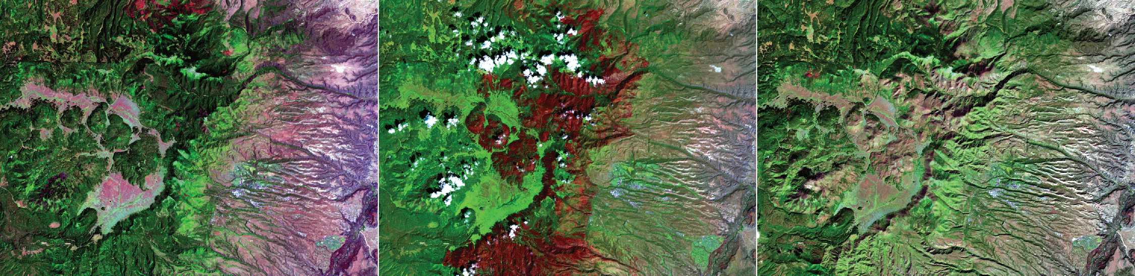
The depth of the Landsat archive tells the story of the Las Conchas wildfire that burned more than 156,000 acres near Los Alamos in June 2011. The left image was acquired days before the wildfire started, the center image shows the footprint of the burned area, and the right image from October 2019 shows the landscape’s partial recovery.
Managing Water Consumption
Water is crucial to agricultural, municipal, industrial, and recreational users throughout New Mexico’s Upper Rio Grande Basin. With changes in climate, ongoing droughts, and decreased water levels in reservoirs, many communities look to groundwater sources to support their agriculture, industry, and homes. Researchers use Landsat data to accurately estimate how much groundwater is evaporating from the soil and vegetation surfaces or transpiring by plants. That information in turn helps measure water use on farm fields and municipalities, improving local water-management decisions (Senay and others, 2019).
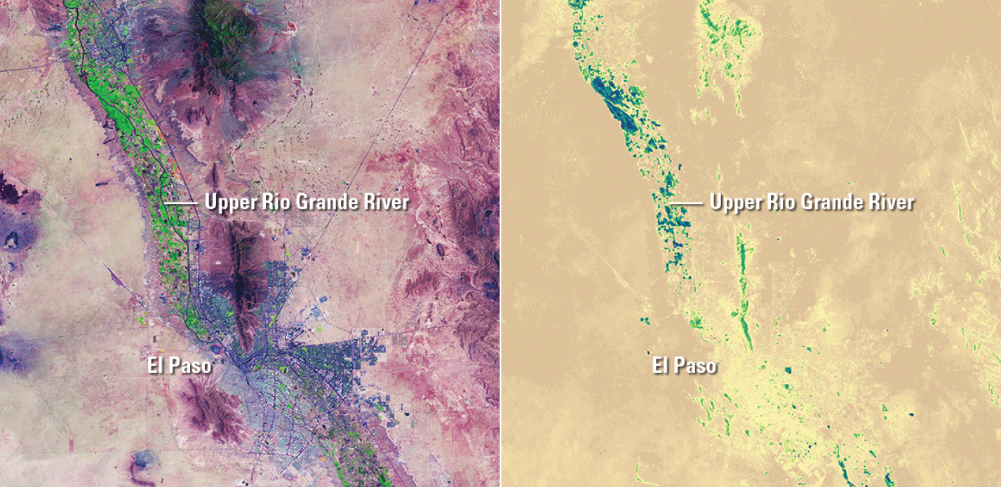
At left, Landsat 8 image from June 7, 2019, shows irrigated land along the Upper Rio Grande River down to El Paso, Texas, and into Mexico. At right, using a USGS Landsat-derived Surface Temperature Model, the map shows a percentage estimate of water loss through evaporation and plant transpiration on the same date.
Preserving Natural Landscapes
New Mexico is known for its spectacular scenery, fascinating natural history, and unique cultural heritage. Landsat assists in the management and preservation of those landscapes. With the 8-day coverage of its two satellites and its almost 50-year archival record, Landsat can document the effects of people and nature on New Mexico’s many national parks and thus help park managers make informed land management decisions (U.S. Department of the Interior, 2020). Where is disease affecting forests? Where is drought affecting biodiversity and ecosystems? Landsat helps to answer those questions.
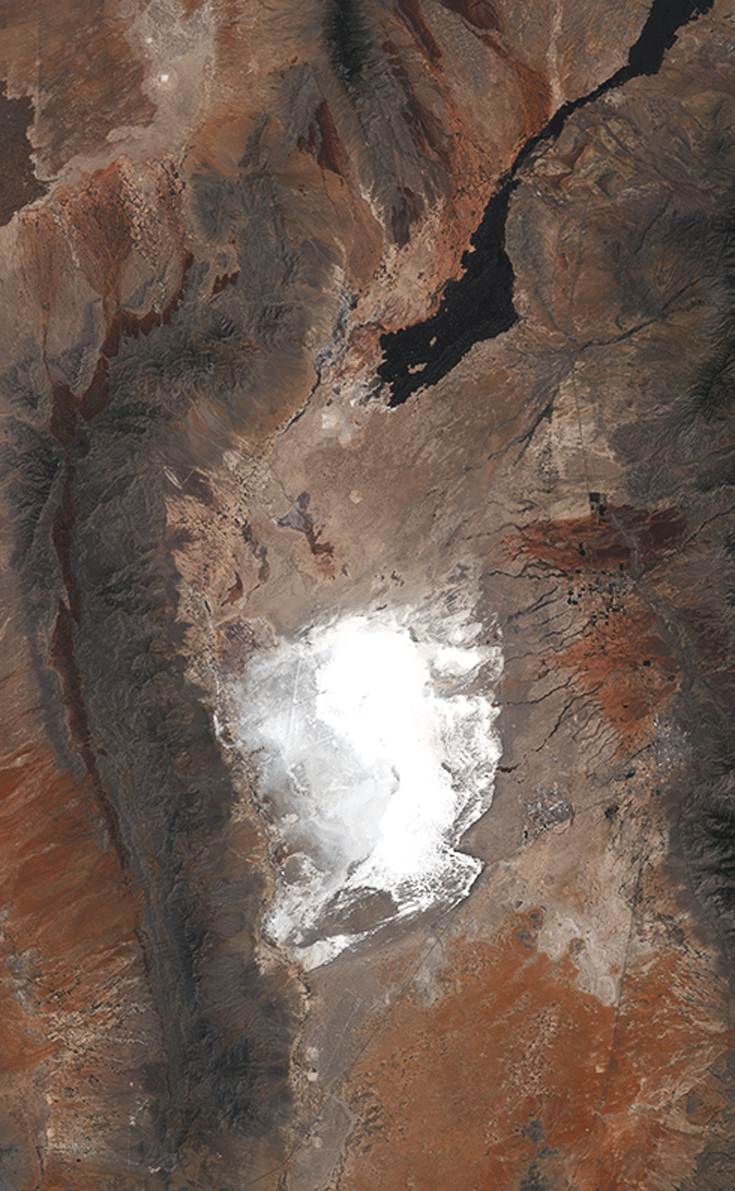
Landsat 8 image from August 2019 of the white sands of White Sands National Monument in southern New Mexico.
National Land Imaging Program Benefits—New Mexico
The U.S. Geological Survey (USGS) National Land Imaging Program provides a wide range of satellite imagery and other remotely sensed and geospatial data to Government, commercial, academic, and public users. Those users can get worldwide access to Landsat satellite data through the National Land Imaging Program-funded USGS Earth Resources Observation and Science (EROS) Center.
Landsat—Critical Information Infrastructure for the Nation
Landsat is the most widely used land remote sensing data source within Federal civilian agencies. Local, State, Tribal, and Federal agencies use Landsat to monitor and forecast a wide range of land surface phenomena. Information from Landsat contributes to day-to-day decisions on land, water, and resource use that protect life and property; safeguard the environment; advance science, technology, and education; support climate resiliency; and grow the U.S. economy. Landsat’s imagery provides a landscape-level view of land surface, inland lake, and coastal processes, both natural and human-induced. Landsat enables us to better understand the scope, nature, and speed of change to the natural and built environment.
Businesses draw upon Landsat data to provide customer-specific applications to improve logistics, resource allocation, and investment decisions. Commercial space imaging firms leverage Landsat data to refine product offerings and support new information services. A 2017 USGS study determined the total annual economic benefit of Landsat data in the United States. to be $2.06 billion, far surpassing its development and operating costs (Straub and others, 2019).
Landsat 8 and Landsat 9 provide 8-day repeat coverage of the Earth’s land surfaces. The National Aeronautics and Space Administration (NASA) and the USGS are currently reviewing the findings from a joint Architecture Study Team, which will inform the design and implementation approach for Landsat Next, the follow-on mission to Landsat 9. Landsat 9 and its successors are planned to provide a sustainable, space-based system to extend the 50-year Landsat series of high-quality global land imaging measurements—the world’s longest time series of the Earth’s land surface.
The long-term availability of consistent and accurate Landsat data, combined with a no-cost data policy, allows users to analyze extensive geographic areas and better understand and manage long-term trends in land surface change. New cloud computing and data analytics technologies use Landsat data in a wide range of decision-support tools for Government and industry. Much like global positioning systems and weather data, Landsat data are used every day to help us better understand our dynamic planet.
References Cited
LANDFIRE, 2022, Frequently asked questions: LANDFIRE web page, accessed June 6, 2022, at https://landfire.cr.usgs.gov/faq.php.
Senay, G.B., Schauer, M., Velpuri, N.M., Singh, R.K., Kagone, S., Friedrichs, M., Litvak, M.E., and Douglas-Mankin, K.R., 2019, Long-term (1986–2015) crop water use characterization over the Upper Rio Grande Basin of United States and Mexico using Landsat-based evapotranspiration: Remote Sensing, v. 11, no. 13, art. 1587, 25 p., accessed June 6, 2022, at https://doi.org/10.3390/rs11131587.
Straub, C.L., Koontz, S.R., and Loomis, J.B., 2019, Economic valuation of Landsat imagery: U.S. Geological Survey Open-File Report 2019–1112, 13 p., accessed June 6, 2022, at https://doi.org/10.3133/ofr20191112.
U.S. Department of the Interior, 2020, NPS [National Park Service]: U.S. Department of the Interior web page, accessed June 8, 2022, at https://eros.usgs.gov/doi-remote-sensing-activities/nps.
For additional information on Landsat, please contact:
Program Coordinator
USGS National Land Imaging Program
12201 Sunrise Valley Drive
Reston, VA 20192
703–648–4567
The Landsat series is a joint effort of USGS and NASA. NASA develops and launches the spacecraft; USGS manages satellite operations, ground reception, data archiving, product generation, and data distribution. Funding for the National Land Imaging Program’s Landsat operations and data management is provided through the USGS.
Disclaimers
Any use of trade, firm, or product names is for descriptive purposes only and does not imply endorsement by the U.S. Government.
Although this information product, for the most part, is in the public domain, it also may contain copyrighted materials as noted in the text. Permission to reproduce copyrighted items must be secured from the copyright owner.
Suggested Citation
U.S. Geological Survey, 2020, New Mexico and Landsat (ver. 1.1, July 2022): U.S. Geological Survey Fact Sheet 2020–3060, 2 p., https://doi.org/10.3133/fs20203060.
ISSN: 2327-6932 (online)
ISSN: 2327-6916 (print)
Study Area
| Publication type | Report |
|---|---|
| Publication Subtype | USGS Numbered Series |
| Title | New Mexico and Landsat |
| Series title | Fact Sheet |
| Series number | 2020-3060 |
| DOI | 10.3133/fs20203060 |
| Edition | Version 1.0: December 21, 2020; Version 1.1: July 12, 2022 |
| Publication Date | December 21, 2020 |
| Year Published | 2020 |
| Language | English |
| Publisher | U.S. Geological Survey |
| Publisher location | Reston, VA |
| Contributing office(s) | Earth Resources Observation and Science (EROS) Center |
| Description | 2 p. |
| Country | United States |
| State | New Mexico |
| Online Only (Y/N) | N |