

Michigan and Landsat
Links
- Document: Report (2.21 MB pdf) , HTML , XML
- Version History: Version History (4.01 kB txt)
- Download citation as: RIS | Dublin Core
Abstract
Water means a lot to Michigan, often called the Great Lakes State. The name “Michigan” comes from an Ojibwe word meaning large, or great, water or lake. As the only State touching four of the five Great Lakes—Michigan, Superior, Huron, and Erie—it claims the longest freshwater coastline in the United States.
Yet Michigan is not just about water—forests, agriculture, mines, cities, and even sand dunes stretch across the State’s landscape. Much of what happens on the land does connect in some way with Michigan’s inland and coastal waters. Michigan relies on a healthy environment to support its residents, abundant tourists, and diverse species of wildlife that call the State and its surrounding waters home. From hundreds of miles above, Landsat satellites provide a clearer picture of the connections among land, water, and the people and wildlife that inhabit the State.
Here are several examples of how Landsat benefits Michigan, especially as it relates to the Great Lakes Restoration Initiative (GLRI). The GLRI is a collaborative effort among Federal agencies and their partners, including adjacent States, that aims to protect and restore the Great Lakes.
Helping Control an Invasive Species
The control and prevention of invasive species—plants, fish, and mussels—is one focus area for the GLRI. For example, Landsat images have helped map the distribution of the dense and towering invasive Phragmites australis (Cav.; Trin. ex Steud.), or common reed, in coastal areas such as southeastern Michigan along Saginaw Bay, Lake St. Clair, and Lake Erie. Left unchecked, the wetland plant reduces habitat for fish, plants, and wildlife; interferes with recreation; and can even be a fire hazard. Mapping stands of common reed aids in their management and environmental remediation by State and local authorities (Naranjo, 2017).
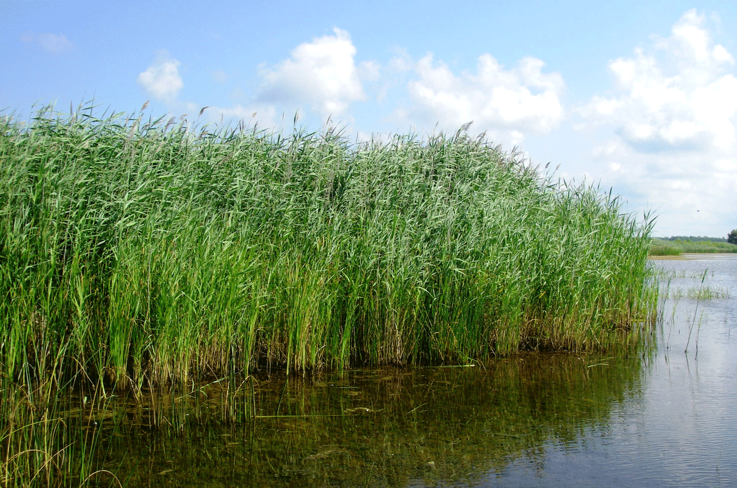
Invasive common reed is a wetland reed that can fill coastal areas with dense, tall stands and cause problems for fish, people, and other plants. Photograph credit: Michigan Department of Environment, Great Lakes, and Energy; used with permission.
Showing Coastal Land Cover Changes
Landsat data form the foundation of the National Oceanic and Atmospheric Administration’s (NOAA) Coastal Change Analysis Program, which maps coastal land cover and land change. The Michigan Coastal Management Program partners with NOAA to help protect and restore the State’s coastline and coastal communities. Aided by the longtime series of Landsat data, the Coastal Change Analysis Program in the Great Lakes Region, with GLRI support, analyzes decades of coastal land-cover change, such as new development, that spurs losses or gains of wetlands, tree and forest cover, grasses, and pavement. Information gained through these analyses is crucial to wetland restoration and other environmental management decisions (NOAA, 2014).
Monitoring Algae Issues
Another major focus in the GLRI action plan is “reducing nutrient runoff that contributes to harmful/nuisance algal blooms” (GLRI, 2021). Landsat images have helped identify algae issues in Michigan’s inland lakes and adjacent Great Lakes via mapping of toxic algal blooms and the nuisance Cladophora spp. (Kützing, 1843) algae, which can detach from underwater rocks or invasive mussels and wash ashore as a mass of green muck (Ramsayer, 2014; Brooks and others, 2015). Landsat data showing forest canopy change also helped U.S. Department of Agriculture (USDA) Forest Service scientists examine the watershed of Lakes Superior and Michigan. Their studies enabled them to predict rising levels of total phosphorus, which feed algae and enter streams draining into those two Great Lakes. Armed with this information, the Forest Service was able to direct resources more efficiently to help improve near-shore water quality (USDA Forest Service—Northern Research Center, 2014).
Informing the Public About a Catastrophe
Landsat satellite images help to visualize the effects of natural or anthropogenic flooding as well. For example, when the Edenville and Sanford Dams failed May 19, 2020, amid floodwaters on the Tittabawassee River in central Michigan, Landsat 8 captured the aftermath the following day (Patel, 2020). In their reporting, media outlets juxtaposed that satellite image with a prior year’s Landsat image to help illustrate the flood’s devastating effects on surrounding land and neighborhoods. A feature called Image of the Week from USGS EROS spotlights other stories of certain events captured by Landsat images.
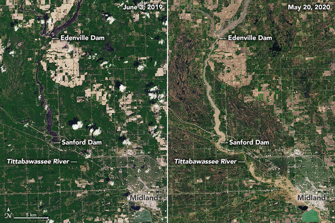
Natural-color Landsat 8 images captured June 3, 2019, and May 20, 2020, show the area around Midland, Michigan, and the upstream Edenville and Sanford Dams before and after the dams were breached following heavy rains May 19, 2020. Image credit: Joshua Stevens of NASA Earth Observatory; and the USGS.
National Land Imaging Program Benefits—Michigan
The U.S. Geological Survey (USGS) National Land Imaging Program provides a wide range of satellite imagery and other remotely sensed and geospatial data to Government, commercial, academic, and public users. Those users can get worldwide access to Landsat satellite data through the National Land Imaging Program-funded USGS Earth Resources Observation and Science (EROS) Center.
Landsat—Critical Information Infrastructure for the Nation
Landsat is the most widely used land remote sensing data source within Federal civilian agencies. Local, State, Tribal, and Federal agencies use Landsat to monitor and forecast a wide range of land surface phenomena. Information from Landsat contributes to day-to-day decisions on land, water, and resource use that protect life and property; safeguard the environment; advance science, technology, and education; support climate change resiliency; and grow the U.S. economy. Landsat’s imagery provides a landscape-level view of land surface, inland lake, and coastal processes, both natural and human-induced. Landsat enables us to better understand the scope, nature, and speed of change to the natural and built environment.
Businesses draw upon Landsat data to provide customer-specific applications to improve logistics, resource allocation, and investment decisions. Commercial space imaging firms leverage Landsat data to refine product offerings and support new information services. A 2017 USGS study determined the total annual economic benefit of Landsat data in the United States. to be $2.06 billion, far surpassing its development and operating costs (Straub and others, 2019).
Landsat 8 and Landsat 9 provide 8-day repeat coverage of the Earth’s land surfaces. The National Aeronautics and Space Administration (NASA) and the USGS are currently reviewing the findings from a joint Architecture Study Team, which will inform the design and implementation approach for Landsat Next, the follow-on mission to Landsat 9. Landsat 9 and its successors are planned to provide a sustainable, space-based system to extend the 50-year Landsat series of high-quality global land imaging measurements—the world’s longest time series of the Earth’s land surface.
The long-term availability of consistent and accurate Landsat data, combined with a no-cost data policy, allows users to analyze extensive geographic areas and better understand and manage long-term trends in land surface change. New cloud computing and data analytics technologies use Landsat data in a wide range of decision-support tools for Government and industry. Much like global positioning systems and weather data, Landsat data are used every day to help us better understand our dynamic planet.
References Cited
Brooks, C., Grimm, A., Shuchman, R., Sayers, M., and Jessee, N., 2015, A satellite-based multi-temporal assessment of the extent of nuisance Cladophora and related submerged aquatic vegetation for the Laurentian Great Lakes: Remote Sensing of Environment, v. 157, p. 58–71. [Also available at https://doi.org/10.1016/j.rse.2014.04.032.]
Great Lakes Restoration Initiative [GLRI], 2021, GLRI action plan: Great Lakes Restoration Initiative web page, accessed August 2021 at https://www.glri.us/action-plan.
Naranjo, L., 2017, Where the wetlands are: National Aeronautics and Space Administration, Landsat Science web page, January 12, 2017, accessed April 2021 at https://landsat.gsfc.nasa.gov/article/where-wetlands-are.
National Oceanic and Atmospheric Administration [NOAA], 2014, Coastal Change Analysis Program: National Aeronautics and Space Administration, Regional Collaboration web page, accessed April 2021 at https://www.regions.noaa.gov/great-lakes/index.php/great_lakes-restoration-initiative/nearshore/coastal-change-analysis-program-c-cap/.
Patel, K., 2020, Muddy flooding in Michigan: National Aeronautics and Space Administration, Earth Observatory web page, May 22, 2020, accessed July 14, 2021, at https://earthobservatory.nasa.gov/images/146752/muddy-flooding-in-michigan.
Ramsayer, K., 2014, Taking NASA-USGS’s Landsat 8 to the beach: National Aeronautics and Space Administration web page, July 2, 2014, accessed April 2021 at https://www.nasa.gov/content/goddard/taking-nasa-usgs-s-landsat-8-to-the-beach/#.U-FjulaKK6A.
Straub, C.L., Koontz, S.R., and Loomis, J.B., 2019, Economic valuation of Landsat imagery: U.S. Geological Survey Open-File Report 2019–1112, 13 p., accessed April 2021 at https://doi.org/10.3133/ofr20191112.
U.S. Department of Agriculture [USDA] Forest Service—Northern Research Center, 2014, Linking land use to Great Lakes water quality: National Aeronautics and Space Administration, Landsat Science web page, August 7, 2014, accessed April 2021 at https://landsat.gsfc.nasa.gov/article/landsat-aids-forest-service-research.
For additional information on Landsat, please contact:
Program Coordinator
USGS National Land Imaging Program
12201 Sunrise Valley Drive
Reston, VA 20192
703–648–4567
The Landsat series is a joint effort of USGS and NASA. NASA develops and launches the spacecraft; USGS manages satellite operations, ground reception, data archiving, product generation, and data distribution. Funding for the National Land Imaging Program’s Landsat operations and data management is provided through the USGS.
Disclaimers
Any use of trade, firm, or product names is for descriptive purposes only and does not imply endorsement by the U.S. Government.
Although this information product, for the most part, is in the public domain, it also may contain copyrighted materials as noted in the text. Permission to reproduce copyrighted items must be secured from the copyright owner.
Suggested Citation
U.S. Geological Survey, 2021, Michigan and Landsat (ver. 1.1, January 2023): U.S. Geological Survey Fact Sheet 2021–3047, 2 p., https://doi.org/10.3133/fs20213047.
ISSN: 2327-6932 (online)
ISSN: 2327-6916 (print)
Study Area
| Publication type | Report |
|---|---|
| Publication Subtype | USGS Numbered Series |
| Title | Michigan and Landsat |
| Series title | Fact Sheet |
| Series number | 2021-3047 |
| DOI | 10.3133/fs20213047 |
| Edition | Version 1.0: August 26, 2021; Version 1.1: January 23, 2023 |
| Publication Date | August 26, 2021 |
| Year Published | 2021 |
| Language | English |
| Publisher | U.S. Geological Survey |
| Publisher location | Reston, VA |
| Contributing office(s) | Earth Resources Observation and Science (EROS) Center |
| Description | 2 p. |
| Country | United States |
| State | Michigan |
| Online Only (Y/N) | N |