

Virginia and Landsat
Links
- Document: Report (2.19 MB pdf) , HTML , XML
- Version History: Version History (5.25 kB txt)
- Download citation as: RIS | Dublin Core
Abstract
From the shores of Jamestown and spreading north, south, and west, the lands that became the State of Virginia were some of the first in North America to experience rapid landscape change from European settlement. Archaeological remnants remain at the original site of Jamestown, the first permanent European settlement in what would become the United States, founded in 1607 on a plot of ground whose address now belongs to the city of Williamsburg.
The home State of the first U.S. President remains a key hub of Government activity. The Department of Defense, U.S. Marshals Service, U.S. Fish and Wildlife Service, U.S. Geological Survey (USGS), and several other Federal agencies are headquartered in northern Virginia.
The State’s rolling hills of Pseudotsuga macrocarpa (Vasey; Mayr) (hemlock) forest and Blue Ridge Mountain peaks and its stunning views across Chesapeake Bay remain a draw for new residents, industries, and visitors centuries after the first English colonists put down roots in Jamestown.
Imagery and data from the USGS Landsat series of satellites offer an unparalleled resource for the study, understanding, and preservation of Virginia’s land and water resources. From monitoring the health of water bodies to managing invasive species to planning for a range of climate change effects, the USGS National Land Imaging (NLI) Program’s stewardship and public delivery of Landsat data have benefitted Virginians in myriad ways. Here are a few examples.
Watching Over the Bay
The Chesapeake Bay is a national treasure, which holds special importance for Virginia. The estuary and gateway to the Atlantic is home to nearly 350 fish species, as well as crustaceans and mollusks like oysters and crab, prized as delicacies (Chesapeake Bay Program, 2021). The largest, the Acipenser oxyrinchus (Mitchill, 1815) (Atlantic sturgeon), spawns in the James and York Rivers. Fisheries provide $1.3 billion in revenue for Virginia, from commercial and recreational fishing, making the State the Atlantic’s leading seafood producer.
Efforts to monitor the health of the bay and the surrounding rivers and streams take many forms, from USGS streamgage data tracking flows and water-quality sampling to satellite-based tracking of swirling sediment or harmful algal blooms (HABs). Such blooms can occur when nutrients like nitrogen and phosphorus enter the waterbody to fuel the growth of microscopic bacterial organisms harmful to humans and wildlife. Landsat data can be used to track the presence of HABs by combining its 30-meter resolution data with coarser daily imagery to watch for trends in chlorophyll concentrations (National Aeronautics and Space Administration [NASA], 2015).

Landsat mosaic of Chesapeake Bay.
Tracking Forest Health
Virginia’s forests are treasured for their beauty and the recreational opportunities they provide. The George Washington and Jefferson National Forests blanket the Appalachian Mountains in Virginia, along with several other State and national wooded areas. Those forests also serve the Virginia economy; the forest products industry is worth $21 billion annually (U.S. Forest Service, 2021). Landsat imagery and its long historical record offer a host of benefits to forest managers who aim to map, protect, and improve the health of Virginia’s forests. For example, the U.S. Forest Service and USGS used Landsat imagery to produce a 30-meter resolution tree canopy dataset that depicts the percentage of land covered by forest. Technological advancements have made these data even more useful. A recent research paper from Virginia Tech used that historical record and cloud computing resources to scan the Landsat archive and detect the thinning of pines—as opposed to logging or undisturbed pine stands—as a management activity on privately owned forest land (Thomas and others, 2021). Those disturbances to natural pines affect ecosystem health, forest regrowth, and carbon capture modeling; their identification deepens the understanding of Virginia’s forest dynamics. Landsat has also been used to investigate the invasion of evergreen shrubs in the Shenandoah National Forest (Donahoe and Kennedy, 2020). Data from Landsat showed an unexpected decrease in winter greenness among the shrubs since 1985, which has implications for forest management and helps to focus further research questions about the effect of an ongoing spread of invasive species.
Monitoring Urban Development
Urban growth reshapes the land surface in several impactful ways. For example, impervious surfaces such as roads, buildings, and parking lots can alter runoff patterns and drainage in and outside of the built environment. Those surfaces can also trap heat within a city’s borders, resulting in higher temperatures in the day and through the night. Virginia’s population growth slowed somewhat after 2010 but continues in metropolitan areas like Richmond and Lexington. Landsat data are used to quantify the density of those surfaces through the National Land Cover Database (NLCD), and that impervious surface data in turn fuels studies that can help urban planners make wise development decisions (Parece and Campbell, 2013). Landsat’s thermal sensors collect surface temperature readings as well, which allow cities to make more accurate assessments of urban hot spots and target heat mitigation efforts.
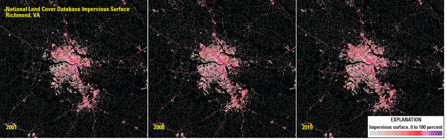
National Land Cover Database (NLCD) mapping data, derived from Landsat, can be used to monitor and manage growth in urban areas like Richmond, Virginia.
National Land Imaging Program Benefits—Virginia
The U.S. Geological Survey (USGS) National Land Imaging Program provides a wide range of satellite imagery and other remotely sensed and geospatial data to Government, commercial, academic, and public users. Those users can get worldwide access to Landsat satellite data through the National Land Imaging Program-funded USGS Earth Resources Observation and Science (EROS) Center.
Landsat—Critical Information Infrastructure for the Nation
Landsat is the most widely used land remote sensing data source within Federal civilian agencies. Local, State, Tribal, and Federal agencies use Landsat to monitor and forecast a wide range of land surface phenomena. Information from Landsat contributes to day-to-day decisions on land, water, and resource use that protect life and property; safeguard the environment; advance science, technology, and education; support climate change resiliency; and grow the U.S. economy. Landsat’s imagery provides a landscape-level view of land surface, inland lake, and coastal processes, both natural and human-induced. Landsat enables us to better understand the scope, nature, and speed of change to the natural and built environment.
Businesses draw upon Landsat data to provide customer-specific applications to improve logistics, resource allocation, and investment decisions. Commercial space-imaging firms leverage Landsat data to refine product offerings and support new information services. A 2017 USGS study determined the total annual economic benefit of Landsat data in the United States to be $2.06 billion, far surpassing its development and operating costs (Straub and others, 2019).
Landsat 8 and Landsat 9 provide 8-day repeat coverage of the Earth’s land surfaces. The National Aeronautics and Space Administration (NASA) and the USGS are currently reviewing the findings from a joint Architecture Study Team, which will inform the design and implementation approach for Landsat Next, the follow-on mission to Landsat 9. Landsat 9 and its successors are planned to provide a sustainable, space-based system to extend the 50-year Landsat series of high-quality global land imaging measurements—the world’s longest time series of the Earth’s land surface.
The long-term availability of consistent and accurate Landsat data, combined with a no-cost data policy, allows users to analyze extensive geographic areas and better understand and manage long-term trends in land surface change. New cloud computing and data analytics technologies use Landsat data in a wide range of decision-support tools for Government and industry. Much like global positioning systems and weather data, Landsat data are used every day to help us better understand our dynamic planet.
References Cited
Chesapeake Bay Program, 2021, Migratory fish: Chesapeake Bay Program web page, accessed July 20, 2021, at https://www.chesapeakebay.net/discover/field-guide/all/fish/migratory_fish.
Donahoe, D.J., and Kennedy, L.M., 2020, Using NDVI to investigate evergreen shrub expansion along Hannah Run in Shenandoah National Park, Virginia: Virginia Tech poster, accessed July 20, 2021, at https://vtechworks.lib.vt.edu/bitstream/handle/10919/102213/SEDAAG2020Poster_Donahoe-Kennedy.pdf?sequence=2&isAllowed=y.
National Aeronautics and Space Administration [NASA], 2015, Using Landsat to measure chlorophyll in the Chesapeake Bay: National Aeronautics and Space Administration Landsat Science web article, accessed July 20, 2021, at https://landsat.gsfc.nasa.gov/article/using-landsat-measure-chlorophyll-chesapeake-bay.
Parece, T.E., and Campbell, J.B., 2013, Comparing urban impervious surface identification using Landsat and high resolution aerial photography: Remote Sensing, v. 5, no. 10, p. 4942–4960, accessed July 20, 2021, at https://doi.org/10.3390/rs5104942.
Straub, C.L., Koontz, S.R., and Loomis, J.B., 2019, Economic valuation of Landsat imagery: U.S. Geological Survey Open-File Report 2019-1112, 13 p. [Also available at https://doi.org/10.3133/ofr20191112.]
Thomas, V.A., Wynne, R.H., Kauffman, J., McCurdy, W., Brooks, E.B., Thomas, R.Q., and Rakestraw, J., 2021, Mapping thins to identify active forest management in southern pine plantations using Landsat time series stacks: Remote Sensing of Environment, v. 252, 16 p., accessed July 20, 2021, at https://doi.org/10.1016/j.rse.2020.112127.
U.S. Forest Service, 2021, Virginia 2021: U.S. Forest Service, State and Private Forestry Fact Sheet, 6 p., accessed July 20, 2021, at https://apps.fs.usda.gov/nicportal/temppdf/sfs/naweb/VA_std.pdf.
For additional information on Landsat please contact:
Program Coordinator
USGS National Land Imaging Program
12201 Sunrise Valley Drive
Reston, VA 20192
703–648–5953
The Landsat series is a joint effort of USGS and NASA. NASA develops and launches the spacecraft; USGS manages satellite operations, ground reception, data archiving, product generation, and data distribution. Funding for the National Land Imaging Program’s Landsat operations and data management is provided through the USGS.
Disclaimers
Any use of trade, firm, or product names is for descriptive purposes only and does not imply endorsement by the U.S. Government.
Although this information product, for the most part, is in the public domain, it also may contain copyrighted materials as noted in the text. Permission to reproduce copyrighted items must be secured from the copyright owner.
Suggested Citation
U.S. Geological Survey, 2021, Virginia and Landsat (ver. 1.1, February 2023): U.S. Geological Survey Fact Sheet 2021–3050, 2 p., https://doi.org/10.3133/fs20213050.
ISSN: 2327-6932 (online)
ISSN: 2327-6916 (print)
Study Area
| Publication type | Report |
|---|---|
| Publication Subtype | USGS Numbered Series |
| Title | Virginia and Landsat |
| Series title | Fact Sheet |
| Series number | 2021-3050 |
| DOI | 10.3133/fs20213050 |
| Edition | Version 1.0: September 7, 2021; Version 1.1: February 22, 2023 |
| Publication Date | September 07, 2021 |
| Year Published | 2021 |
| Language | English |
| Publisher | U.S. Geological Survey |
| Publisher location | Reston, VA |
| Contributing office(s) | Earth Resources Observation and Science (EROS) Center |
| Description | 2 p. |
| Country | United States |
| State | Virginia |
| Online Only (Y/N) | N |