

Colorado and Landsat
Links
- Document: Report (4.72 MB pdf) , HTML , XML
- Version History: Version History (2 kB txt)
- Download citation as: RIS | Dublin Core
Abstract
Colorado’s geography seems designed to impress. Although the Rocky Mountains take up only one-half of the State, more than 50 of its peaks rise at least 14,000 feet above sea level—far more “fourteeners” than any other State. Many of these mountains receive hundreds of inches of snow annually. The Rockies provide the Continental Divide, or watershed boundary, for North America. Three of the United States’ seven longest rivers originate in Colorado’s mountains: the Rio Grande, the Colorado, and the Arkansas. The mountains are also home to 11 national forests. Residents and tourists find numerous ways to appreciate the stunning views, from hiking and skiing to camping and birdwatching, in ecosystems that also include grasslands and shrublands.
Colorado also has the tallest sand dunes in North America and striking red sandstone formations, like those surrounding the Red Rocks Amphitheatre outside of Denver. The eastern edge of Colorado consists of dry plains. The region between the plains and the mountains’ Front Range—the Colorado Piedmont—contains most of the fast-growing State’s 5.7 million people, many of whom live in the Front Range Urban Corridor that includes Fort Collins, Boulder, Denver, and Colorado Springs. The Piedmont’s reservoirs support municipalities, recreation, and irrigated agriculture.
For Colorado’s people and economy to continue to thrive, the State’s residents need to better understand their landscapes and natural resources, now and into the future. Landsat provides data to help government officials and other land managers make knowledgeable decisions about their environment and natural resources.
Here are a few examples of the ways that Landsat benefits Colorado.
Monitoring Water and Agriculture
Water availability is a significant issue in Colorado. Melting mountain snowpack keeps rivers flowing, but low precipitation is typical for the Colorado Plateau region in the extreme west and for the Piedmont and plains regions in the east. Irrigation accounts for the vast majority of freshwater used in Colorado, sustaining corn, wheat, hay, sorghum, and fruit trees, among other products. Landsat has helped the Colorado Water Conservation Board in various ways: to identify irrigated and non-irrigated land, to estimate the amount of water consumed by irrigated crops, to identify crop types during growing seasons, and to identify areas of vegetation that consume high amounts of water. These types of data can assist public and private water management planning and enable more effective and precise water use (Serbina and Miller, 2014).
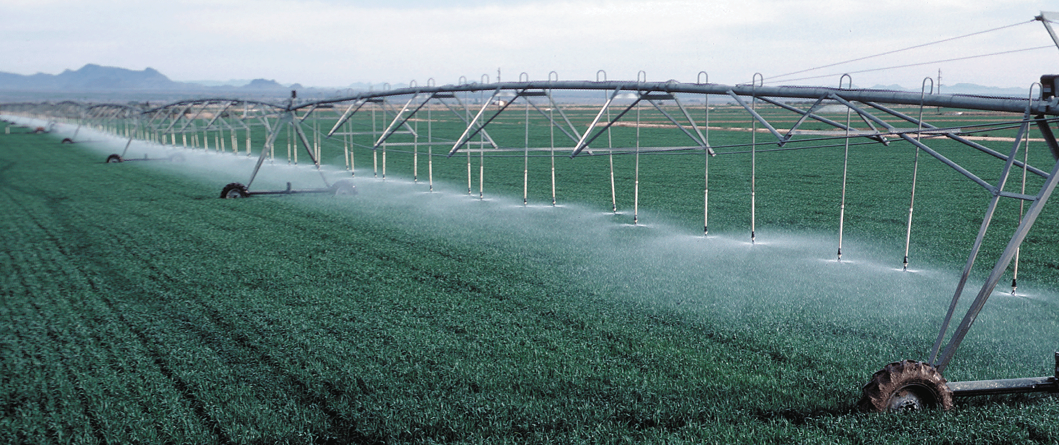
A wheat field being irrigated in Yuma County, Colorado. Photograph credit: Gene Alexander, U.S. Department of Agriculture Natural Resources Conservation Service.
Sustainable Forest and Ecosystem Management
Colorado’s 24 million acres of forests contain deciduous and coniferous trees across a variety of landscapes. Monitoring the health of vast forest lands—especially in rugged mountains—can be difficult from the ground. But satellite imagery offers insights about the effects of disturbances like forest fires, insect outbreaks, and climate change, which affect wildlife habitat, carbon storage and much more. A recent study involving researchers from seven universities and The Nature Conservancy used Landsat imagery from 1997 to 2019 to map the presence and severity of tree mortality caused by several bark beetle species in the southern Rocky Mountains. Understanding patterns in historical disturbances help Coloradans anticipate the implications of future disturbances (Rodman and others, 2021).
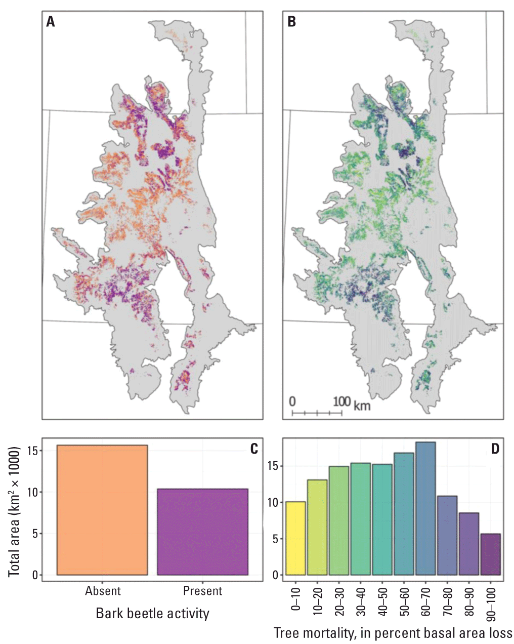
Maps showing the, A, presence and, B, severity of bark beetle-caused tree mortality from 1997 to 2019 throughout the southern Rocky Mountains. Graphs showing the, C, total area of presence/absence and, D, total area with different outbreak severities summarize maps A and B, respectively. Image credit: Rodman and others, 2021; used with permission. [km, kilometer; km2, square kilometer]
Assessing Revegetation at Energy Sites
Outside of agriculture, Landsat can reveal vegetation patterns to help in effective environmental management, such as reducing the effects of invasive species or assessing potential wildfire fuels. One USGS study used Landsat imagery from 1984 to 2011 to assess how vegetation grew back on several hundred oil and gas pads across the Colorado Plateau after they were developed, capped, reclaimed, and abandoned. Understanding vegetation recovery at these sites, which vary in climate and soil conditions, can help guide energy development and land management decisions, including addressing areas where undesirable invasive species are likely to thrive (Waller and others, 2018).
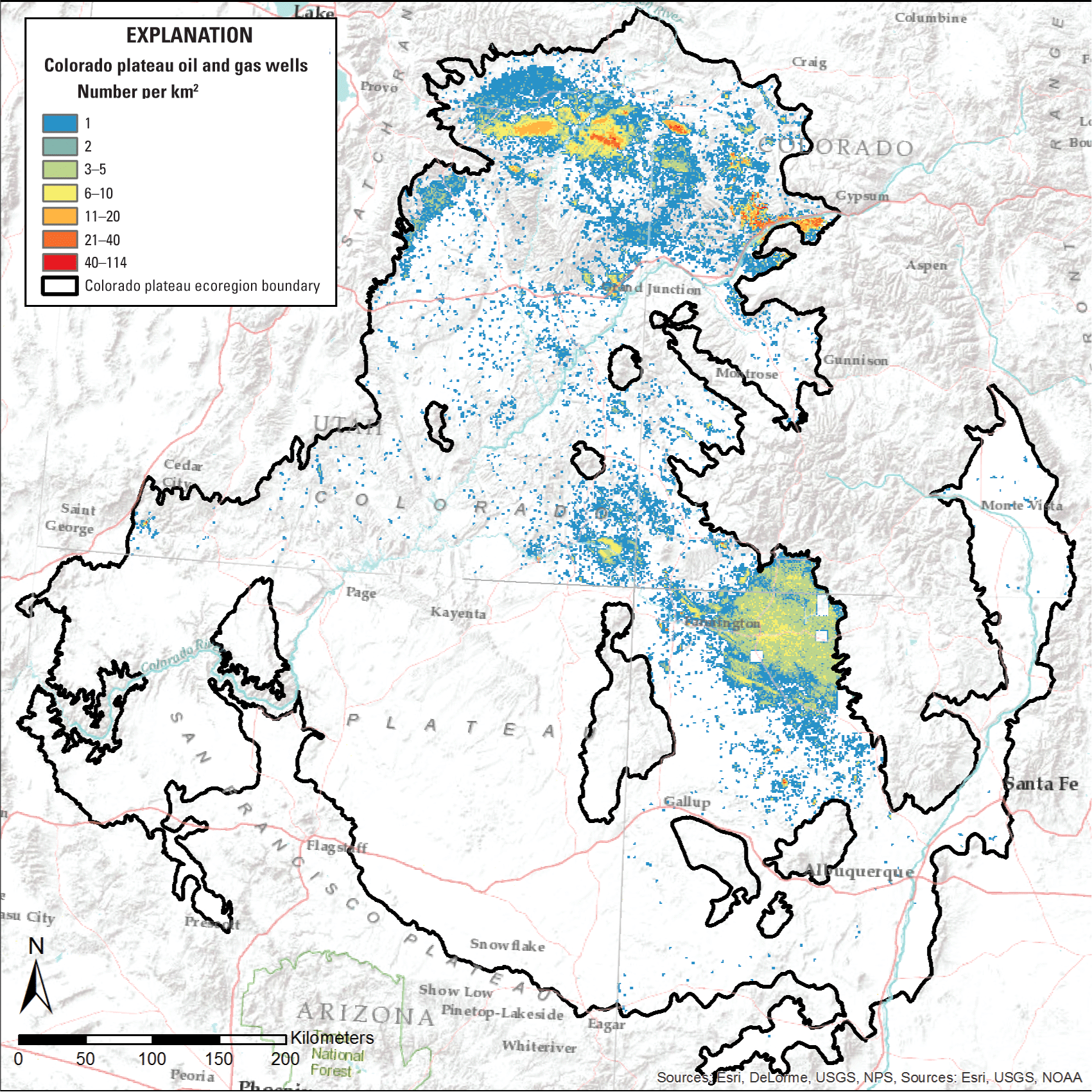
This map shows the overall density of oil and gas well pads per square kilometer (km2) in the Colorado Plateau ecoregion (including parts of Utah, Colorado, and New Mexico) as counted in 2016. In this region, 100,000 abandoned and current wells have spanned 60 years of activity. Image credit: U.S. Geological Survey.
National Land Imaging Program Benefits—Colorado
The U.S. Geological Survey (USGS) National Land Imaging Program provides a wide range of satellite imagery and other remotely sensed and geospatial data to Government, commercial, academic, and public users. Those users can get worldwide access to Landsat satellite data through the National Land Imaging Program-funded USGS Earth Resources Observation and Science (EROS) Center.
Landsat—Critical Information Infrastructure for the Nation
Landsat is the most widely used land remote sensing data source within Federal civilian agencies. Local, State, Tribal, and Federal agencies use Landsat to monitor and forecast a wide range of land surface phenomena. Information from Landsat contributes to day-to-day decisions on land, water, and resource use that protect life and property; safeguard the environment; advance science, technology, and education; support climate change resiliency; and grow the U.S. economy. Landsat’s imagery provides a landscape-level view of land surface, inland lake, and coastal processes, both natural and human-induced. Landsat enables us to better understand the scope, nature, and speed of change to the natural and built environment.
Businesses draw upon Landsat data to provide customer-specific applications to improve logistics, resource allocation, and investment decisions. Commercial space imaging firms leverage Landsat data to refine product offerings and support new information services. A 2017 USGS study determined the total annual economic benefit of Landsat data in the United States to be $2.06 billion, far surpassing its development and operating costs (Straub and others, 2019).
Landsat 8 and Landsat 9 provide 8-day repeat coverage of the Earth’s land surfaces. The National Aeronautics and Space Administration (NASA) and the USGS are currently reviewing the findings from a joint Architecture Study Team, which will inform the design and implementation approach for Landsat Next, the follow-on mission to Landsat 9. Landsat 9 and its successors are planned to provide a sustainable, space-based system to extend the 50-year Landsat series of high-quality global land imaging measurements--the world’s longest time series of the Earth’s land surface. The long-term availability of consistent and accurate Landsat data, combined with a no-cost data policy, allows users to analyze extensive geographic areas and better understand and manage long-term trends in land surface change. New cloud computing and data analytics technologies use Landsat data in a wide range of decision-support tools for Government and industry. Much like global positioning systems and weather data, Landsat data are used every day to help us better understand our dynamic planet.
The long-term availability of consistent and accurate Landsat data, combined with a no-cost data policy, allows users to analyze extensive geographic areas and to better understand and manage long-term trends in land surface change. New cloud computing and data analytics technologies use Landsat data in a wide range of decision-support tools for Government and industry. Much like global positioning system and weather data, Landsat data are used every day to help us better understand our dynamic planet.
References Cited
Rodman, K., Andrus, R., Butkiewicz, C., Chapman, T., Gill, N., Harvey, B., Kulakowski, D., Tutland, N., Veblen, T., and Hart, S., 2021, 2021, Effects of bark beetle outbreaks on forest landscape pattern in the southern Rocky Mountains, U.S.A: Remote Sensing (Basel), v. 13, no. 6, p. 1089, accessed October 21, 2021, at https://doi.org/10.3390/rs13061089.
Serbina, L., Miller, H.M., 2014, Landsat uses and benefits—Case studies by application area: U.S. Geological Survey Open-File Report 2014–1108, 61 p., accessed October 21, 2021, at https://doi.org/10.3133/ofr20141108.
Straub, C.L., Koontz, S.R., and Loomis, J.B., 2019, Economic valuation of Landsat imagery: U.S. Geological Survey Open-File Report 2019–1112, 13 p., accessed October 21, 2021, at https://pubs.er.usgs.gov/publication/ofr20191112.
Waller, E., Villarreal, M., Poitras, T., Nauman, T., and Duniway, M., 2018, 2018, Landsat time series analysis of fractional plant cover changes on abandoned energy development sites: International Journal of Applied Earth Observation and Geoinformation, v. 73, p. 407–419, accessed October 21, 2021, at https://doi.org/10.1016/j.jag.2018.07.008.
For additional information on Landsat please contact:
Program Coordinator
USGS National Land Imaging Program
12201 Sunrise Valley Drive
Reston, VA 20192
703–648–5953
The Landsat series is a joint effort of USGS and NASA. NASA develops and launches the spacecraft; USGS manages satellite operations, ground reception, data archiving, product generation, and data distribution. Funding for the National Land Imaging Program’s Landsat operations and data management is provided through the USGS.
Disclaimers
Any use of trade, firm, or product names is for descriptive purposes only and does not imply endorsement by the U.S. Government.
Although this information product, for the most part, is in the public domain, it also may contain copyrighted materials as noted in the text. Permission to reproduce copyrighted items must be secured from the copyright owner.
Suggested Citation
U.S. Geological Survey, 2022, Colorado and Landsat (ver. 1.1, January 2023): U.S. Geological Survey Fact Sheet 2022–3004, 2 p., https://doi.org/10.3133/fs20223004.
ISSN: 2327-6932 (online)
ISSN: 2327-6916 (print)
Study Area
| Publication type | Report |
|---|---|
| Publication Subtype | USGS Numbered Series |
| Title | Colorado and Landsat |
| Series title | Fact Sheet |
| Series number | 2022-3004 |
| DOI | 10.3133/fs20223004 |
| Edition | Version 1.0: February 10, 2022; Version 1.1: January 13, 2023 |
| Publication Date | February 10, 2022 |
| Year Published | 2022 |
| Language | English |
| Publisher | U.S. Geological Survey |
| Publisher location | Reston, VA |
| Contributing office(s) | Earth Resources Observation and Science (EROS) Center |
| Description | 2 p. |
| Country | United States |
| State | Colorado |
| Online Only (Y/N) | N |