

Idaho and Landsat
Links
- Document: Report (4.87 MB pdf) , HTML , XML
- Version History: Version History (2 kB txt)
- Download citation as: RIS | Dublin Core
Abstract
Idaho may be popular for potatoes, but the State’s richness also lies in its scenery and natural resources. Its terrain varies from mountains, rivers, and waterfalls to forests, volcanic rock, and hot springs. A growing population gives Idaho even more reason to use the best information available to serve the needs of its residents while wisely managing its environment and natural resources.
Soon after the first Landsat satellite launched, Idaho recognized how useful its data could be. In 1975, the Idaho Department of Water Resources (IDWR) started using data from Landsat 1 and has since used data from every subsequent Landsat satellite.
Here is a closer look at Landsat as a key tool for monitoring water, along with other examples of Landsat’s value to Idaho.
Water Management in Agriculture
In 2000, the IDWR, in partnership with the University of Idaho, began using Landsat to map evapotranspiration (ET), or the movement of water into the atmosphere via evaporation and plant transpiration. Mapping ET at the level of individual agricultural fields helps the IDWR predict irrigation needs for upcoming growing seasons and provides for a longer-term look at supply and demand. In 2009, the Innovations in American Government Award honored Idaho for the State’s use of Landsat ET data. The success of the ET program in Idaho affected the design of Landsat 8 to include a thermal infrared sensor critical to ET modeling. The IDWR has used Landsat data for hydrologic modeling; land cover classification; water right compliance, buy-backs, and curtailments; and making related legal determinations (Idaho Department of Water Resources, 2021).
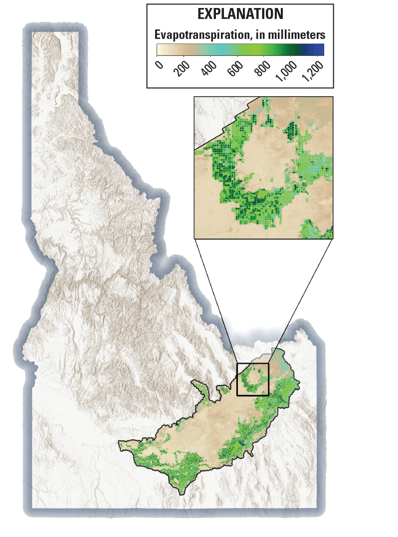
This map, using Landsat data, shows evapotranspiration for Idaho cropland for the 2018 growing season, indicating irrigation’s consumptive use of water. It was clipped to the bounds of the Idaho Department of Water Resources’ Eastern Snake Plain groundwater model. Image credit: Idaho Department of Water Resources; used with permission.
Rangeland Wildfires
A significant factor in wildfires on Idaho’s sagebrush rangeland is Bromus tectorum (cheatgrass), an invasive species that spreads fast, greens up, and then dies quickly. The dried vegetation left behind provides a carpet of kindling to fuel fires that flare up in increasing frequency and size due to a changing climate. Researchers have been able to use Landsat data to help map rangeland for the Bureau of Land Management in Idaho, show where cheatgrass infestations exist, identify greening-up areas that later could turn into fire fuel, and indicate where cheatgrass is likely to invade next. This information can help State and Federal officials make plans for prescribed burns and ecosystem recovery (Idaho State University Marketing and Communications, 2015).
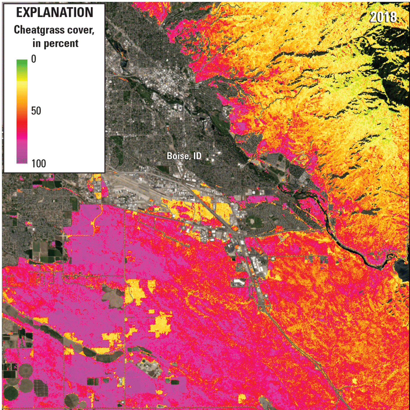
This image shows a 2018 cheatgrass coverage map for the Boise, Idaho, area atop a Landsat 8 image of the same area. Image credit: U.S. Geological Survey.
Wildlife Habitat
A landscape as diverse as Idaho’s serves as a home to equally diverse wildlife. Studies by researchers have shown that Landsat can be useful for monitoring the animals’ changing habitats, such as Centrocercus urophasianus (sage grouse), and help State and Federal agencies make related management decisions (Homer and others, 2015). Landsat data were used, for example, to create habitat suitability maps to help the Idaho Department of Fish and Game prioritize where to survey for the threatened, and rarely sighted, Coccyzus americanus (western yellow-billed cuckoo) (National Aeronautics and Space Administration, 2017).

The western yellow-billed cuckoo. Photograph credit: Peter Pearsall, U.S. Fish and Wildlife Service.
National Land Imaging Program Benefits—Idaho
The U.S. Geological Survey (USGS) National Land Imaging Program provides a wide range of satellite imagery and other remotely sensed and geospatial data to Government, commercial, academic, and public users. Those users can get worldwide access to Landsat satellite data through the National Land Imaging Program-funded USGS Earth Resources Observation and Science (EROS) Center.
Landsat—Critical Information Infrastructure for the Nation
Landsat is the most widely used land remote sensing data source within Federal civilian agencies. Local, State, Tribal, and Federal agencies use Landsat to monitor and forecast a wide range of land surface phenomena. Information from Landsat contributes to day-to-day decisions on land, water, and resource use that protect life and property; safeguard the environment; advance science, technology, and education; support climate change resiliency; and grow the U.S. economy. Landsat’s imagery provides a landscape-level view of land surface, inland lake, and coastal processes, both natural and human-induced. Landsat enables us to better understand the scope, nature, and speed of change to the natural and built environment.
Businesses draw upon Landsat data to provide customer-specific applications to improve logistics, resource allocation, and investment decisions. Commercial space imaging firms leverage Landsat data to refine product offerings and support new information services. A 2017 USGS study determined the total annual economic benefit of Landsat data in the United States. to be $2.06 billion, far surpassing its development and operating costs (Straub and others, 2019).
Landsat 8 and Landsat 9 provide 8-day repeat coverage of the Earth’s land surfaces. The National Aeronautics and Space Administration (NASA) and the USGS are currently reviewing the findings from a joint Architecture Study Team, which will inform the design and implementation approach for Landsat Next, the follow-on mission to Landsat 9. Landsat 9 and its successors are planned to provide a sustainable, space-based system to extend the 50-year Landsat series of high-quality global land imaging measurements—the world’s longest time series of the Earth’s land surface.
The long-term availability of consistent and accurate Landsat data, combined with a no-cost data policy, allows users to analyze extensive geographic areas and better understand and manage long-term trends in land surface change. New cloud computing and data analytics technologies use Landsat data in a wide range of decision-support tools for Government and industry. Much like global positioning systems and weather data, Landsat data are used every day to help us better understand our dynamic planet.
References Cited
Idaho Department of Water Resources, 2021, Mapping evapotranspiration and Landsat Thermal Band: Idaho Department of Water Resources web pages, accessed December 23, 2021, at https://idwr.idaho.gov/gis/mapping-evapotranspiration/.
Idaho State University Marketing and Communications, 2015, A Landsat-based tool to track cheatgrass, monitor potential wildfire hazard: NASA Landsat Science web page, August 7, 2015, accessed December 23, 2021, at https://landsat.gsfc.nasa.gov/article/a-landsat-based-tool-to-track-cheatgrass-monitor-potential-wildfire-hazard/.
Homer, C.G., Xian, G., Aldridge, C.L., Meyer, D.K., Loveland, T.R., and O’Donnell, M.S., 2015, 2015, Forecasting sagebrush ecosystem components and greater sage-grouse habitat for 2050—Learning from past climate patterns and Landsat imagery to predict the future: Ecological Indicators, v. 55, p. 131–145, accessed December 23, 2021, https://www.sciencedirect.com/science/article/pii/S1470160X15001156?via%3Dihub.
National Aeronautics and Space Administration, 2017, Using NASA Earth observations to identify current habitat areas and forecast habitat suitability for the yellow-billed cuckoo in semiarid environments: NASA DEVELOP web page, 2017, accessed December 23, 2021, at https://develop.larc.nasa.gov/2017/spring/IntermountainWestEco.html.
Straub, C.L., Koontz, S.R., and Loomis, J.B., 2019, Economic valuation of Landsat imagery: U.S. Geological Survey Open-File Report 2019–1112, 2019, 13 p., accessed December 23, 2021, at https://doi.org/10.3133/ofr20191112.
For additional information on Landsat, please contact:
Program Coordinator
USGS National Land Imaging Program
12201 Sunrise Valley Drive
Reston, VA 20192
703–648–4567
The Landsat series is a joint effort of USGS and NASA. NASA develops and launches the spacecraft; USGS manages satellite operations, ground reception, data archiving, product generation, and data distribution. Funding for the National Land Imaging Program’s Landsat operations and data management is provided through the USGS.
Disclaimers
Any use of trade, firm, or product names is for descriptive purposes only and does not imply endorsement by the U.S. Government.
Although this information product, for the most part, is in the public domain, it also may contain copyrighted materials as noted in the text. Permission to reproduce copyrighted items must be secured from the copyright owner.
Suggested Citation
U.S. Geological Survey, 2022, Idaho and Landsat (ver. 1.1, January 2023): U.S. Geological Survey Fact Sheet 2022–3013, 2 p., https://doi.org/10.3133/fs20223013.
ISSN: 2327-6932 (online)
ISSN: 2327-6916 (print)
Study Area
| Publication type | Report |
|---|---|
| Publication Subtype | USGS Numbered Series |
| Title | Idaho and Landsat |
| Series title | Fact Sheet |
| Series number | 2022-3013 |
| DOI | 10.3133/fs20223013 |
| Edition | Version 1.0: March 8, 2022; Version 1.1: January 23, 2023 |
| Publication Date | March 08, 2022 |
| Year Published | 2022 |
| Language | English |
| Publisher | U.S. Geological Survey |
| Publisher location | Reston, VA |
| Contributing office(s) | Earth Resources Observation and Science (EROS) Center |
| Description | 2 p. |
| Country | United States |
| State | Idaho |
| Online Only (Y/N) | N |