

Washington and Landsat
Links
- Document: Report (6.51 MB pdf) , HTML , XML
- Version History: Version History (1.85 kB txt)
- Download citation as: RIS | Dublin Core
Abstract
Washington is a State of untamed wonders, from its ruggedly beautiful coastline to the volcanic peaks of the Cascades. “The Evergreen State” is also a State of contrasts, home to rainforests west of the Cascades and deserts to the east. Half of Washington is forested, and its orchards grow more than one-half of the apples sold in the United States. Rivers are important to the State, particularly the Columbia River, the largest North American river that flows into the Pacific Ocean. Dozens of dams have been constructed in the river basin, including the largest hydroelectric producer in the Nation, the Grand Coulee Dam.
Washington’s diverse landscapes also change in various ways over time. Some are relatively steady, like urban expansion in the populous Puget Sound region. Others can be sudden, like the Mount Saint Helens eruption in 1980—one of the largest volcanic eruptions that caused the largest landslide in U.S. history. Although landscape change may be hard to detect at any one time, the Landsat program provides an objective view of it over decades. Landsat not only allows one to see what Mount Saint Helens looked like before and after the eruption, but also how the area has evolved since.
Here are a few examples of how Landsat benefits Washington.
Tracking Mount Saint Helens’ Recovery
Before Mount Saint Helens erupted, old-growth forests of Douglas fir (Pseudotsuga menziesii) and hemlocks (P. macrocarpa) surrounded the volcano. The eruption and subsequent landslides to the north burned, buried, or toppled trees, leaving behind a view more moonscape than landscape. But the area didn’t remain that way; in the 40+ years since the eruption, forests and other vegetation have started over. Scientists with the U.S. Department of Agriculture (USDA) Forest Service have taken the opportunity to study this unusually drastic disturbance by using Landsat data to track the recovery of trees and vegetation and to develop a model that helps predict the percentage of tree cover (USDA Forest Service, 2020).
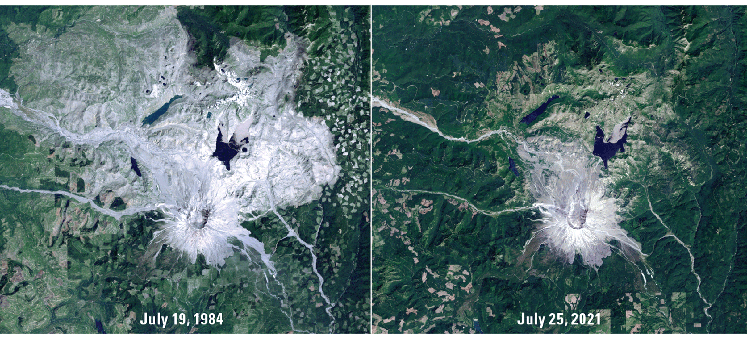
Landsat images of Mount Saint Helens from July 19, 1984 (left), and July 25, 2021 (right), showing revegetation over time. Image credit: U.S. Geological Survey.
Monitoring Landscapes and Habitats
Small changes in land cover are no less important to monitor than large disturbances. Landsat’s lengthy archive can reveal trends in the past to help plan for the future. The National Park Service, for example, implemented a protocol to monitor landscape dynamics at Olympic National Park using Landsat-based Detection of Trends in Disturbance and Recovery (LandTrendr) algorithms. The 922,000-acre park includes coastal wilderness, rainforest, and mountainous landscapes. Using 26 years of Landsat data, the National Park Service mapped eight categories of change, including forest clearing and wildland fire, in and around the park (Copass and others, 2016). Likewise, researchers from the National Oceanic and Atmospheric Administration and Oregon State University used LandTrendr to map 23 years of land cover next to habitats of the threatened Chinook salmon (Oncorhynchus tshawytscha) in the Puget Sound to see how much of the land had become developed (Bartz and others, 2015).
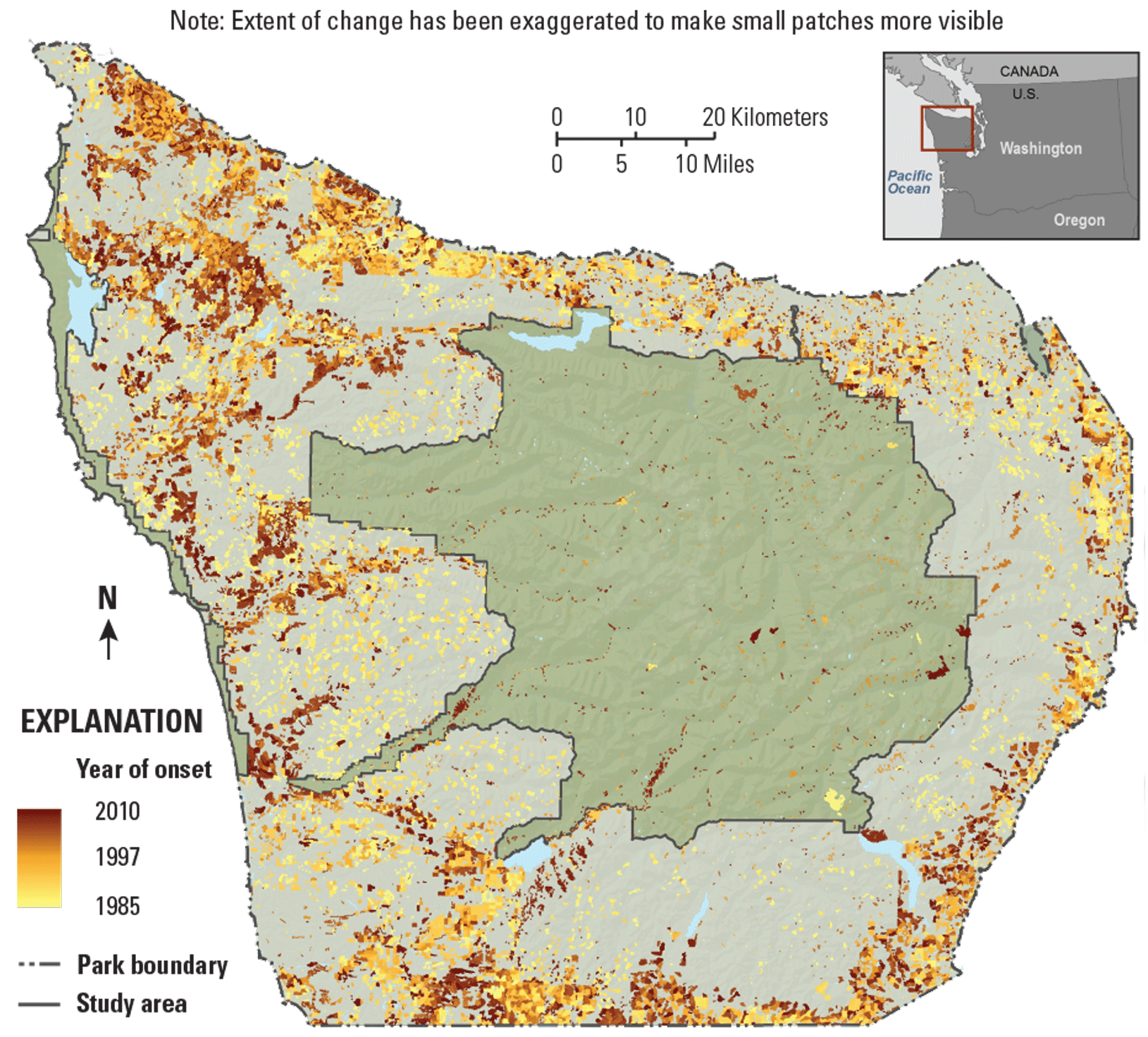
This map, derived from Landsat data, shows landscape changes from 1985 to 2010 by year of onset in and around Olympic National Park. Image credit: National Park Service.
Assessing the Aftermath of Fires
Washington, like other western States, experiences increasingly severe wildfires. One of the many fire mapping tools that use Landsat data is Rehabilitation Capacity Convergence for Ecosystem Recovery (RECOVER), developed by NASA, Idaho State University, and the Bureau of Land Management to incorporate several relevant data layers. RECOVER helps to rapidly provide data about a fire’s effects that can help land managers make assessments and decisions. In the aftermath of wildfires burning near Spokane in 2016, for example, a National Weather Service hydrologist and a team of scientists used RECOVER to map burn severity, which is derived from an EROS and USDA Forest Service data layer, and to analyze the risk for resulting flash flooding or debris flows (NASA, 2021).
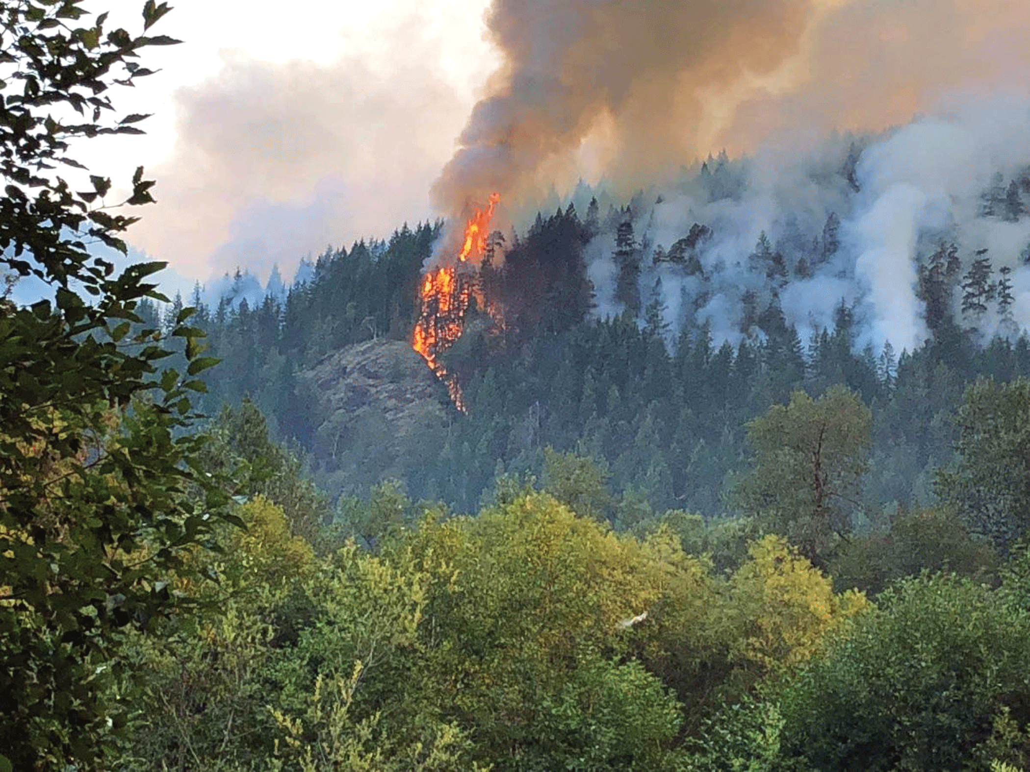
A fire burning in the Olympic National Forest. Photograph credit: U.S. Department of Agriculture Forest Service.
National Land Imaging Program Benefits—Washington
The U.S. Geological Survey (USGS) National Land Imaging Program provides a wide range of satellite imagery and other remotely sensed and geospatial data to Government, commercial, academic, and public users. Those users can get worldwide access to Landsat satellite data through the National Land Imaging Program-funded USGS Earth Resources Observation and Science (EROS) Center.
Landsat—Critical Information Infrastructure for the Nation
Landsat is the most widely used land remote sensing data source within Federal civilian agencies. Local, State, Tribal, and Federal agencies use Landsat to monitor and forecast a wide range of land surface phenomena. Information from Landsat contributes to day-to-day decisions on land, water, and resource use that protect life and property; safeguard the environment; advance science, technology, and education; support climate change resiliency; and grow the U.S. economy. Landsat’s imagery provides a landscape-level view of land surface, inland lake, and coastal processes, both natural and human-induced. Landsat enables us to better understand the scope, nature, and speed of change to the natural and built environment.
Businesses draw upon Landsat data to provide customer-specific applications to improve logistics, resource allocation, and investment decisions. Commercial space-imaging firms leverage Landsat data to refine product offerings and support new information services. A 2017 USGS study determined the total annual economic benefit of Landsat data in the United States to be $2.06 billion, far surpassing its development and operating costs (Straub and others, 2019).
Landsat 8 and Landsat 9 provide 8-day repeat coverage of the Earth’s land surfaces. The National Aeronautics and Space Administration (NASA) and the USGS are currently reviewing the findings from a joint Architecture Study Team, which will inform the design and implementation approach for Landsat Next, the follow-on mission to Landsat 9. Landsat 9 and its successors are planned to provide a sustainable, space-based system to extend the 50-year Landsat series of high-quality global land imaging measurements—the world’s longest time series of the Earth’s land surface.
The long-term availability of consistent and accurate Landsat data, combined with a no-cost data policy, allows users to analyze extensive geographic areas and better understand and manage long-term trends in land surface change. New cloud computing and data analytics technologies use Landsat data in a wide range of decision-support tools for Government and industry. Much like global positioning systems and weather data, Landsat data are used every day to help us better understand our dynamic planet.
References Cited
Bartz, K.K., Ford, M.J., Beechie, T.J., Fresh, K.L., Pess, G.R., Kennedy, R.E., Rowse, M.L., and Sheer, M., 2015, Trends in developed land cover adjacent to habitat for threatened salmon in Puget Sound, Washington, USA: PloS One, April 29, 2015, accessed October 13, 2021, at https://www.ncbi.nlm.nih.gov/pmc/articles/PMC4414273/.
Copass, C., Antonova, N., and Clary, S., 2016, Landsat-based monitoring of landscape dynamics in Olympic National Park—1985-2010: National Park Service Natural Resource Data Series NPS/NCCN/NRDS—2016/1053, August 2016, accessed October 13, 2021, at https://irma.nps.gov/DataStore/DownloadFile/554508.
National Aeronautics and Space Administration [NASA], 2021, Wildlife recovery on the West Coast: NASA Space for U.S. web page, accessed October 13, 2021, at https://www.nasa.gov/SpaceforUS/?story=4100.
Straub, C.L., Koontz, S.R., and Loomis, J.B., 2019, Economic valuation of Landsat imagery: U.S. Geological Survey Open-File Report 2019–1112, 13 p., accessed October 13, 2021, at https://doi.org/10.3133/ofr20191112.
U.S. Department of Agriculture [USDA] Forest Service, 2020, RMRS, NASA track 40 years of recovery on Mt. St. Helens: USDA Forest Service web page, June 15, 2020, accessed October 13, 2021, at https://www.fs.usda.gov/inside-fs/delivering-mission/apply/rmrs-nasa-track-40-years-recovery-mt-st-helens.
For additional information on Landsat please contact:
Program Coordinator
USGS National Land Imaging Program
12201 Sunrise Valley Drive
Reston, VA 20192
703–648–5953
The Landsat series is a joint effort of USGS and NASA. NASA develops and launches the spacecraft; USGS manages satellite operations, ground reception, data archiving, product generation, and data distribution. Funding for the National Land Imaging Program’s Landsat operations and data management is provided through the USGS.
Disclaimers
Any use of trade, firm, or product names is for descriptive purposes only and does not imply endorsement by the U.S. Government.
Although this information product, for the most part, is in the public domain, it also may contain copyrighted materials as noted in the text. Permission to reproduce copyrighted items must be secured from the copyright owner.
Suggested Citation
U.S. Geological Survey, 2022, Washington and Landsat (ver. 1.1, January 2023): U.S. Geological Survey Fact Sheet 2022–3021, 2 p., https://doi.org/10.3133/fs20223021.
ISSN: 2327-6932 (online)
ISSN: 2327-6916 (print)
Study Area
| Publication type | Report |
|---|---|
| Publication Subtype | USGS Numbered Series |
| Title | Washington and Landsat |
| Series title | Fact Sheet |
| Series number | 2022-3021 |
| DOI | 10.3133/fs20223021 |
| Edition | Version 1.0: April 25, 2022; Version 1.1: January 24, 2023 |
| Publication Date | April 25, 2022 |
| Year Published | 2022 |
| Language | English |
| Publisher | U.S. Geological Survey |
| Publisher location | Reston, VA |
| Contributing office(s) | Earth Resources Observation and Science (EROS) Center |
| Description | 2 p. |
| Country | United States |
| State | Washington |
| Online Only (Y/N) | N |