

Utah and Landsat
Links
- Document: Report (3.83 MB pdf) , HTML , XML
- Version History: Version History (1.85 kB txt)
- Download citation as: RIS | Dublin Core
Abstract
Utah’s list of notable features runs long, but scenery rises to the top. The Colorado River does not simply run through southeastern Utah; it meanders through steep canyons of the eroded sedimentary rock that colors the sweeping vistas of the Colorado Plateau. Stone arches, spires, hoodoos, cliffs, and bridges in hues of red enchant residents and tourists. Mountain ranges extending through the State add dynamic views—and skiing opportunities.
The Great Salt Lake in northern Utah is the largest saltwater lake in the Western Hemisphere. The western part of Utah, including the Great Salt Lake, lies in the Great Basin, a multi-State drainage area with no outlet. Because the lake has no outlet to flush out any salt, evaporation produces a higher concentration of salts in the water or soils, called salinity. The lake lacks fish but supports algae and brine shrimp, and extensive wetlands around the lake attract millions of migratory birds.
Landsat imagery is useful for showing surface changes, such as the fluctuating water levels of the shallow Great Salt Lake. The lake flooded in the 1980s, but the southern part dropped to its lowest level in recorded history in 2021. Landsat data also can take a much deeper look at land and water conditions. Here are several ways Landsat benefits Utah.
Watching Water Use
Prolonged droughts have taken a toll across the western United States. The water level in the Colorado River’s Lake Powell reservoir on the Utah-Arizona border dropped to a historic low in 2021. The 2019 Colorado River Drought Contingency Plan is an agreement among the seven Colorado Basin States, including Utah, that aims to reduce the risks of drought, and to sustain and protect the basin’s water. Adequate water supplies are critical for residents, industries, and recreation in Utah, which has long relied on irrigation to sustain its important agricultural industry. Landsat helps model how much water is used in irrigation by measuring water evaporation from the soil and transpiration from plants, known as evapotranspiration (ET). The Utah Department of Natural Resources’ Agricultural Water Optimization Task Force has included Landsat-based ET measurements in a recommendation for a more quantifiable method to administer irrigation water rights (Jacobs Engineering Group, 2020).
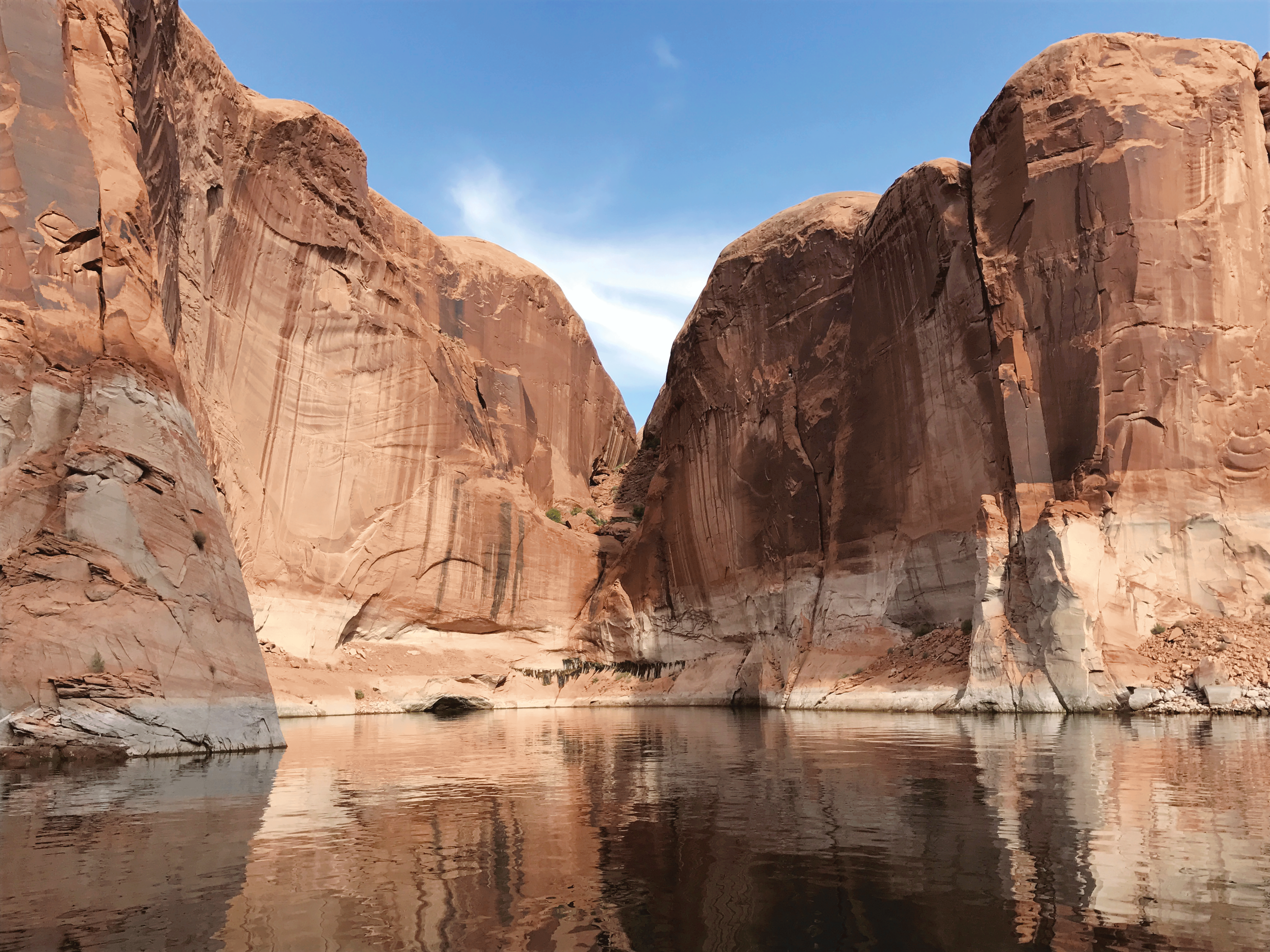
Lake Powell, the Colorado River reservoir behind Glen Canyon Dam, extends from Arizona into Utah. The light-colored ring around the canyon walls represents the high-water mark for the lake. In 2021, the lake reached its lowest level since the reservoir was filled. Photograph credit: Wayne Baldwin, U.S. Geological Survey.
Providing Wildfire Information
Utah experiences hundreds of wildfires each year. The multi-agency partnership Landscape Fire and Resource Management Planning Tools (LANDFIRE) maps vegetation type using Landsat and builds layers of data used by a range of fire agencies, land managers, and scientists to better understand the landscape’s ecological makeup and fire vulnerability. The Utah Division of Forestry, Fire, and State Lands includes LANDFIRE data in its Utah Wildfire Risk Assessment Portal (Utah Division of Forestry, Fire, & State Lands, 2022). Additionally, Utah State University is creating a Utah Fire Atlas from the Landsat-based Monitoring Trends in Burn Severity maps of Utah fires greater than 1,000 acres and its own maps of smaller fires based on Landsat imagery dating to 1984 (Utah Forest Institute, 2020).
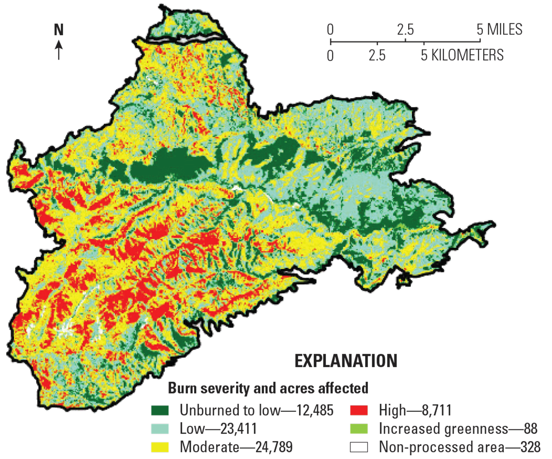
The Dollar Ridge Fire burned nearly 70,000 acres in north central Utah in July 2018. Image credit: Monitoring Trends in Burn Severity by the U.S. Geological Survey and U.S. Department of Agriculture Forest Service.
Detecting Harmful Water
Harmful algal blooms (HABs), caused by a proliferation of cyanobacteria in bodies of fresh water, produce toxins that can harm humans and animals and result in economic losses. Satellites can help health officials and scientists find blooms sooner and monitor large areas more easily. For example, in June 2017, Landsat imagery detected a bloom in Provo Bay of Utah Lake. Confirmed by lab tests, the bloom prompted the Utah Department of Environmental Quality to issue a recreational advisory (Ramsayer, 2021). A subsequent study by researchers at Georgetown University, Resources for the Future, and the U.S. Environmental Protection Agency estimated that without satellite involvement, detection of the Utah Lake bloom likely would have occurred about 7 days later. During those 7 days, the study estimated about 8,000 visitors would have been exposed to toxins, resulting in an estimated $370,000 in medical care and lost productivity (Stroming and others, 2020).
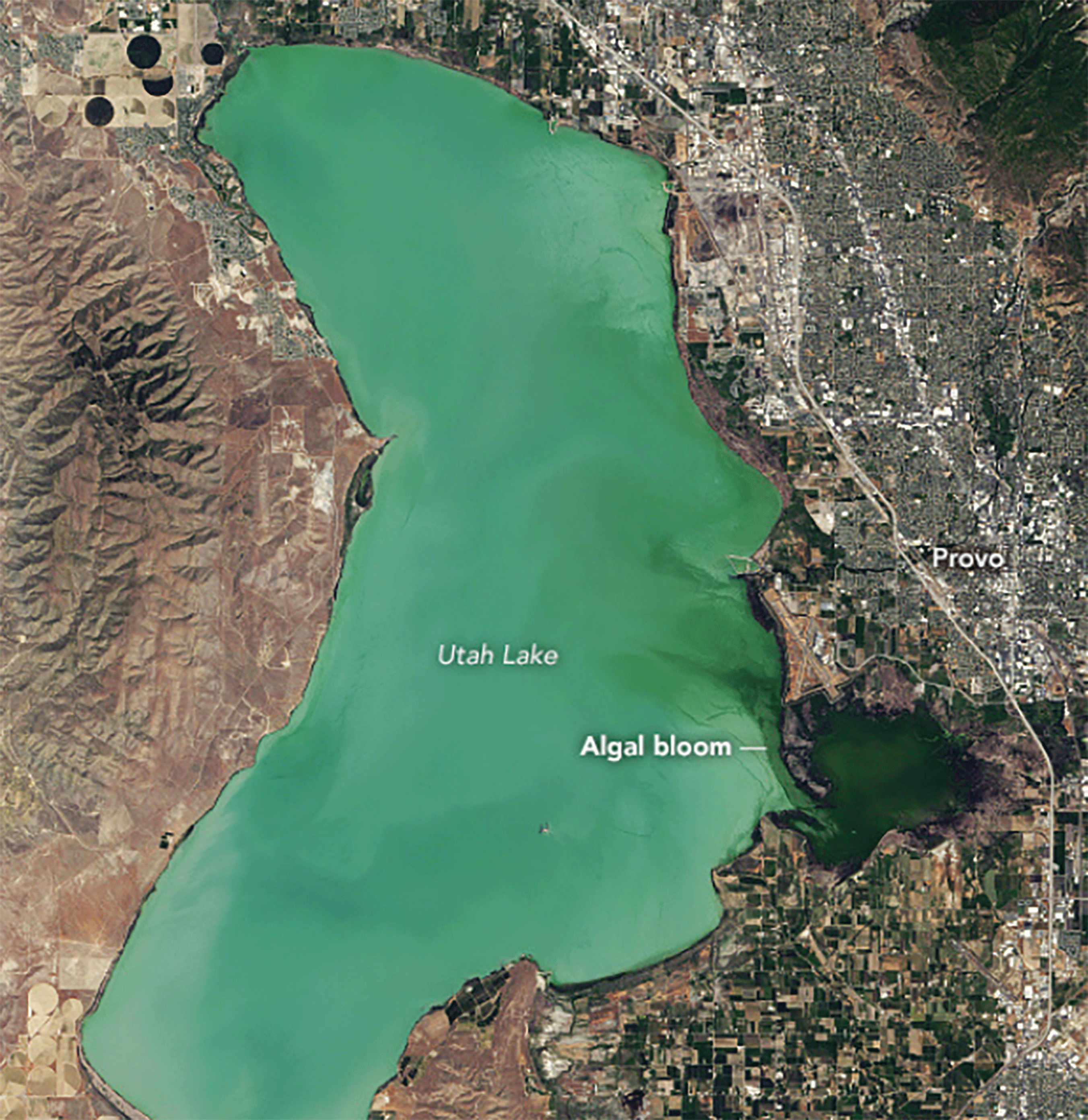
This natural-color Landsat 8 image points out a deep green algal bloom on Utah Lake on June 20, 2017. Image credit: National Aeronautics and Space Administration and U.S. Geological Survey.
National Land Imaging Program Benefits—Utah
The U.S. Geological Survey (USGS) National Land Imaging Program provides a wide range of satellite imagery and other remotely sensed and geospatial data to Government, commercial, academic, and public users. Those users can get worldwide access to Landsat satellite data through the National Land Imaging Program-funded USGS Earth Resources Observation and Science (EROS) Center.
Landsat—Critical Information Infrastructure for the Nation
Landsat is the most widely used land remote sensing data source within Federal civilian agencies. Local, State, Tribal, and Federal agencies use Landsat to monitor and forecast a wide range of land surface phenomena. Information from Landsat contributes to day-to-day decisions on land, water, and resource use that protect life and property; safeguard the environment; advance science, technology, and education; support climate change resiliency; and grow the U.S. economy. Landsat’s imagery provides a landscape-level view of land surface, inland lake, and coastal processes, both natural and human-induced. Landsat enables us to better understand the scope, nature, and speed of change to the natural and built environment.
Businesses draw upon Landsat data to provide customer-specific applications to improve logistics, resource allocation, and investment decisions. Commercial space-imaging firms leverage Landsat data to refine product offerings and support new information services. A 2017 USGS study determined the total annual economic benefit of Landsat data in the United States to be $2.06 billion, far surpassing its development and operating costs (Straub and others, 2019).
Landsat 8 and Landsat 9 provide 8-day repeat coverage of the Earth’s land surfaces. The National Aeronautics and Space Administration (NASA) and the USGS are currently reviewing the findings from a joint Architecture Study Team, which will inform the design and implementation approach for Landsat Next, the follow-on mission to Landsat 9. Landsat 9 and its successors are planned to provide a sustainable, space-based system to extend the 50-year Landsat series of high-quality global land imaging measurements—the world’s longest time series of the Earth’s land surface.
The long-term availability of consistent and accurate Landsat data, combined with a no-cost data policy, allows users to analyze extensive geographic areas and better understand and manage long-term trends in land surface change. New cloud computing and data analytics technologies use Landsat data in a wide range of decision-support tools for Government and industry. Much like global positioning systems and weather data, Landsat data are used every day to help us better understand our dynamic planet.
References Cited
Jacobs Engineering Group, 2020, Depletion accounting for irrigation water rights in Utah, a review of potential agricultural depletion accounting methods: Utah Department of Natural Resources report, June 26, 2020, accessed February 9, 2022, at https://water.utah.gov/wp-content/uploads/2020/06/2020AgDepletionMethodsReport_FINAL.pdf.
Ramsayer, K., 2021, Landsat satellite data warns of harmful algal blooms: National Aeronautics and Space Administration web page, March 22, 2021, accessed February 9, 2022, at https://www.nasa.gov/feature/goddard/2021/landsat-satellite-data-warns-of-harmful-algal-blooms.
Straub, C.L., Koontz, S.R., and Loomis, J.B., 2019, Economic valuation of Landsat imagery: U.S. Geological Survey Open-File Report 2019–1112, 13 p., accessed January 13, 2022, at https://doi.org/10.3133/ofr20191112.
Stroming, S., Robertson, M., Mabee, B., Kuwayama, Y., and Schaeffer, B., 2020, 2020, Quantifying the human health benefits of using satellite information to detect cyanobacterial harmful algal blooms and manage recreational advisories in U.S. lakes: GeoHealth, v. 4, no. 9, accessed February 9, 2022, at https://doi.org/10.1029/2020GH000254.
Utah Division of Forestry, Fire, and State Lands, 2022, Utah Wildfire Risk Assessment: Utah Division of Forestry, Fire, and State Lands web page, accessed February 9, 2022, at https://ffsl.utah.gov/fire/utah-wildfire-risk-assessment/.
Utah Forest Institute, 2020, Enhancing our ecological understanding of wildfire for better land management in the beehive state: Utah State University Utah Forest Institute web page, 2020, accessed February 9, 2022, at http://utahforestinstitute.org/expertise.html.
For additional information on Landsat please contact:
Program Coordinator
USGS National Land Imaging Program
12201 Sunrise Valley Drive
Reston, VA 20192
703–648–5953
The Landsat series is a joint effort of USGS and NASA. NASA develops and launches the spacecraft; USGS manages satellite operations, ground reception, data archiving, product generation, and data distribution. Funding for the National Land Imaging Program’s Landsat operations and data management is provided through the USGS.
Disclaimers
Any use of trade, firm, or product names is for descriptive purposes only and does not imply endorsement by the U.S. Government.
Although this information product, for the most part, is in the public domain, it also may contain copyrighted materials as noted in the text. Permission to reproduce copyrighted items must be secured from the copyright owner.
Suggested Citation
U.S. Geological Survey, 2022, Utah and Landsat (ver. 1.1, January 2023): U.S. Geological Survey Fact Sheet 2022–3023, 2 p., https://doi.org/10.3133/fs20223023.
ISSN: 2327-6932 (online)
ISSN: 2327-6916 (print)
Study Area
| Publication type | Report |
|---|---|
| Publication Subtype | USGS Numbered Series |
| Title | Utah and Landsat |
| Series title | Fact Sheet |
| Series number | 2022-3023 |
| DOI | 10.3133/fs20223023 |
| Edition | Version 1.0: April 26, 2022; Version 1.1: January 24, 2023 |
| Publication Date | April 26, 2022 |
| Year Published | 2022 |
| Language | English |
| Publisher | U.S. Geological Survey |
| Publisher location | Reston, VA |
| Contributing office(s) | Earth Resources Observation and Science (EROS) Center |
| Description | 2 p. |
| Country | United States |
| State | Utah |
| Online Only (Y/N) | N |