

Water Priorities for the Nation—U.S. Geological Survey Integrated Water Prediction Science Program
Links
- Document: Report (2.88 MB pdf) , HTML , XML
- NGMDB Index Page: National Geologic Map Database Index Page (html)
- Download citation as: RIS | Dublin Core
Abstract
The Integrated Water Prediction (IWP) science program within the U.S. Geological Survey (USGS) Water Resources Mission Area (WMA) focuses on the development of advanced models for forecasting water availability by simulating components of the water cycle and water quality attributes such as temperature, water constituents, and the ecological conditions these attributes produce. The IWP science program also is developing the cyberinfrastructure required to implement national and local-scale models to be used by water resource managers over the decades ahead.
The IWP science program is developing a new approach to hydrologic modeling that incorporates state-of-the-art Earth science and provides the capability necessary to objectively evaluate models. By incorporating leading-edge software design principles in model development, the program can provide timely predictions that can be used by a variety of stakeholders in their decision making.
The IWP team is currently spearheading efforts in three different areas:
Understanding Multiscale Processes
A comprehensive view of the combined natural and human elements of the water cycle is shown in figure 1. To better understand the multiscale processes of the water cycle, the IWP science program is developing and testing new and existing models to describe the water budget and forecast different water cycle components under various scenarios including changing climate, human population growth, and land use changes. Another objective is to develop integrated models for water quality, water use, and ecological conditions.
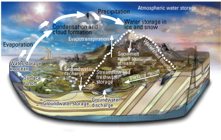
Among other objectives, the Integrated Water Prediction science program is developing models and the computational infrastructure needed to characterize and predict multiple facets of the water cycle (modified from Evenson and others, 2013).
Activity example.—USGS researchers are creating state-of-the-art 7-day forecasts of water temperatures and flows in the Delaware and Upper Colorado River Basins that incorporate real-time data and data associated with reservoir operations. This capacity can be expanded to new basins, or nationally, and generates useful information for water managers who need to balance human needs with thermal and flow regulations.
Hydro-Terrestrial Earth Systems Testbeds
Testbeds will be an integral component of the IWP science program workflow (fig. 2). The USGS is creating the computational testing environment required to accelerate and improve the process of hydrologic model development by the water science community. In collaboration with partners at the National Center for Atmospheric Research, the USGS is formalizing a process to integrate the modeling and computational capacity of multiple organizations to identify the science and technological needs that can serve the Nation’s hydrologic prediction capacity at national, regional, drainage basin, and local scales into the future. This collaboration provides the critical capacity of model benchmarking to ensure that future model development is guided by the best available science.
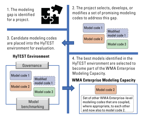
Overview of the Integrated Water Prediction science program workflow highlighting the roles of the hydro-terrestrial Earth systems testbed (HyTEST) and enterprise capacity efforts.
Activity example.—USGS scientists are integrating our understanding of hydrology and climate, including the effects that the hydrologic cycle and its processes have on Earth’s climate. This collaborative effort will result in a new hydroclimate dataset that spans 40 years into the past and 20 years into the future (a projection) for the continental United States and will be useful to multiple projects within and outside the USGS.
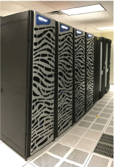
Photograph showing USGS supercomputers housed at the USGS Earth Resources Observation and Science Center. The computational and modeling strengths of the USGS and other Federal agencies will be important for the implementation of the IWP science program. Photograph by Steven M. Young, USGS.
Enhancing Enterprise Capacity
Enterprise capacity also forms a critical step in the IWP workflow (fig. 2). Through the IWP science program, the USGS will establish new architecture and standards required to perform integrated hydrologic modeling. This effort focuses on the following objectives: (1) cataloging and characterizing existing hydrological modeling software; (2) evaluating the software design principles of existing hydrologic models to identify factors that may hinder development of more advanced models; and (3) fostering a community approach to support the long-term implementation, maintenance, and evolution of hydrologic models.
Activity example.—USGS researchers working to support enterprise capacity are focusing on development of the best practices for connecting the hydrologic models that are used by the broader modeling community. Initial efforts focused on existing USGS WMA models such as MODFLOW (https://www.usgs.gov/mission-areas/water-resources/science/modflow-and-related-programs) and can expand to include new model development and models from the broader hydrologic community. The recommendations developed can lead to an ecosystem of modeling codes recognized as the state of the science for estimating components of water availability that are linked to one another.
Developing and Implementing Integrated Water Predictions
Development of the IWP modeling ecosystem is driven by stakeholder needs at local to national scales. Early IWP modeling efforts are expected to focus on WMA Integrated Water Science basins including the Delaware, Upper Colorado, Illinois, and Willamette River Basins (fig. 3; Van Metre and others, 2020; www.usgs.gov/iws). Work in the Integrated Water Science basins can inform the development of national scale models and is expected to be completed in conjunction with other collaborators internal and external to the USGS.
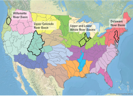
Major hydrologic regions of the continental United States. The Delaware, Upper Colorado, and Illinois River Basins were selected in 2019, 2020, and 2021, respectively, to serve as Integrated Water Science Basins. The Willamette River Basin was most recently selected for Integrated Water Science implementation in 2022, and additional basins are planned to be added each year through 2028.
References Cited
Evenson, E.J., Orndorff, R.C., Blome, C.D., Böhlke, J.K., Hershberger, P.K., Langenheim, V.E., McCabe, G.J., Morlock, S.E., Reeves, H.W., Verdin, J.P., Weyers, H.S., and Wood, T.M., 2013, U.S. Geological Survey water science strategy—Observing, understanding, predicting, and delivering water science to the Nation: U.S. Geological Survey Circular 1383–G, 49 p. [Also available at https://doi.org/10.3133/cir1383G.]
Van Metre, P.C., Qi, S., Deacon, J., Dieter, C., Driscoll, J.M., Fienen, M., Kenney, T., Lambert, P., Lesmes, D., Mason, C.A., Mueller-Solger, A., Musgrove, M., Painter, J., Rosenberry, D., Sprague, L., Tesoriero, A.J., Windham-Myers, L., and Wolock, D., 2020, Prioritizing river basins for intensive monitoring and assessment by the US Geological Survey: Environmental Monitoring and Assessment, v. 192, art. 458, 17 p., accessed December 2021 at https://doi.org/10.1007/s10661-020-08403-1.
Contact information:
Water Resources Mission Area
U.S. Geological Survey
12201 Sunrise Valley Drive
Reston, VA 20192
703–648–5953
For additional information, visit: https://www.usgs.gov/mission-areas/water-resources
Publishing support provided by the Reston, Rolla, and Sacramento Publishing Service Centers
Disclaimers
Any use of trade, firm, or product names is for descriptive purposes only and does not imply endorsement by the U.S. Government.
Although this information product, for the most part, is in the public domain, it also may contain copyrighted materials as noted in the text. Permission to reproduce copyrighted items must be secured from the copyright owner.
Suggested Citation
Miller, M.P., Skalak, K., and Lesmes, D.P., 2022, Water priorities for the Nation—U.S. Geological Survey Integrated Water Prediction science program: U.S. Geological Survey Fact Sheet 2022–3028, 2 p., https://doi.org/10.3133/fs20223028.
ISSN: 2327-6932 (online)
ISSN: 2327-6916 (print)
Study Area
| Publication type | Report |
|---|---|
| Publication Subtype | USGS Numbered Series |
| Title | Water priorities for the Nation—U.S. Geological Survey Integrated Water Prediction science program |
| Series title | Fact Sheet |
| Series number | 2022-3028 |
| DOI | 10.3133/fs20223028 |
| Publication Date | May 03, 2022 |
| Year Published | 2022 |
| Language | English |
| Publisher | U.S. Geological Survey |
| Publisher location | Reston, VA |
| Contributing office(s) | Office of the Associate Director for Water |
| Description | 2 p. |
| Country | United States |
| Online Only (Y/N) | N |
| Additional Online Files (Y/N) | N |