

Georgia and Landsat
Links
- Document: Report (4.86 MB pdf) , HTML , XML
- Version History: Version History (1 KB txt)
- Download citation as: RIS | Dublin Core
Abstract
Georgia’s nickname is “The Peach State” for its fruitful production, but it also could be called “The State of Abundance.” Georgia ranks in the top 10 States for population, at more than 10 million residents, and 6 million residents are in the greater Atlanta area. Georgia also ranks in the top 10 States for forest areas with 24 million acres, or about two-thirds of the State. Its trees vary from deciduous hardwoods and pines to cypress and magnolias.
Georgia has diverse ecosystems, from the Blue Ridge Mountains in the northeast to the hilly, populous Piedmont region in the middle to the vast Coastal Plains that cover the southern half of the State with farms, forests, and wetlands. The State’s 14 major river basins, including the Chattahoochee and the Savannah, ultimately drain to the Atlantic Ocean or the Gulf of America. Millions of acres of wetlands include floodplain wetlands, freshwater swamps such as the Okefenokee Swamp, and coastal marshes. More than a dozen barrier islands lie off Georgia’s coastline. Wildlife in these myriad habitats include black bears, alligators, armadillos, manatees, sea turtles, and more than 40 species of snakes.
The Landsat satellite imagery scale and its 50-year record of Earth observations make Landsat ideal for monitoring changes in these diverse environments and supporting decision-making by government officials and land managers. Here are several ways Landsat has benefited Georgia.
Revealing Land Cover Changes
GeorgiaView (https://gaview.org/drupal893/)—a member of the national AmericaView education and outreach consortium (https://americaview.org/)—supports remote sensing use throughout the State. Since 2019, GeorgiaView has published three volumes of the Georgia Land Cover Image Atlas based largely on Landsat data (GeorgiaView, 2021). Each volume contains maps for each of Georgia’s congressional districts, regional commissions, and 159 counties. The first volume, called “Impact of Urbanization,” maps land cover and land use in 2011 and lists the change in developed area between 2001 and 2011. The “Croplands” volume maps the location of crop types grown in 2018. The “Forest Change” volume maps the location and extent of tree loss between 2000 and 2019. These atlases provide easy access to ecosystem information for local and regional officials.
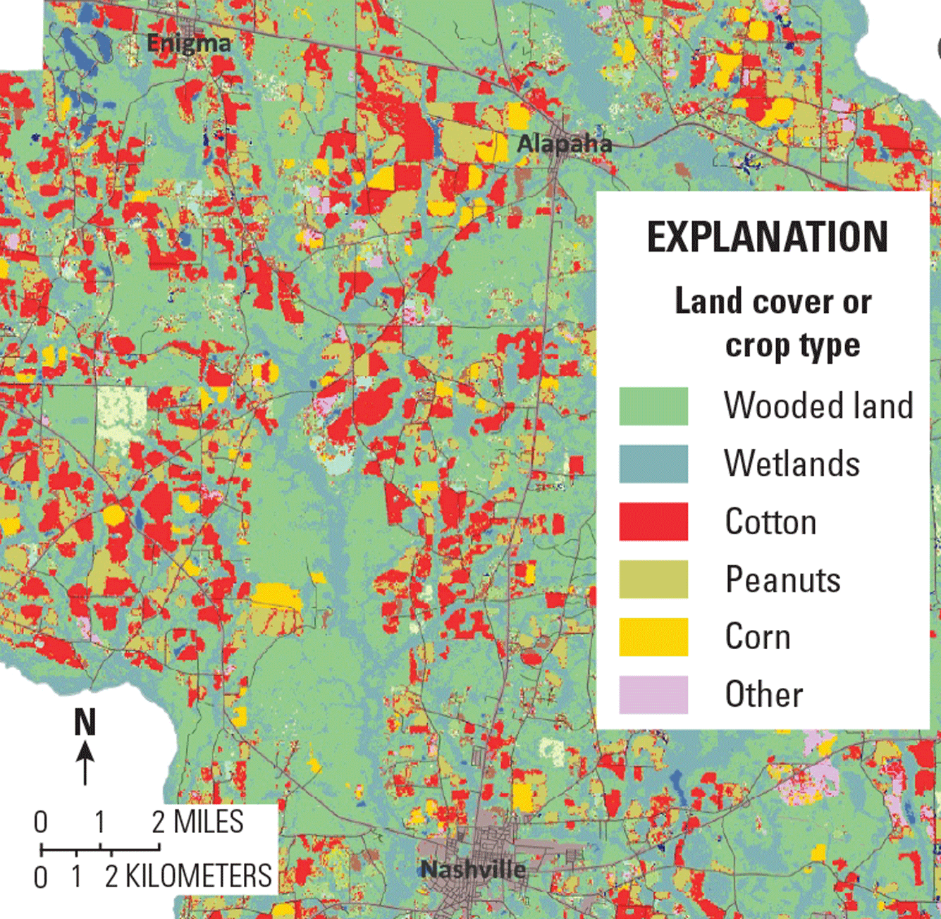
This map in the “Croplands” volume of the Georgia Land Cover Image Atlas shows the crops planted in 2018 in a section of Berrien County, in the middle of Georgia’s southern agricultural belt. Forests and wetlands are the dominant land cover categories, but cotton (red) was by far the dominant crop planted. Image credit: Dr. Jeong Seong, University of West Georgia and GeorgiaView; used with permission.
Finding Patterns of Forest Change
Forests provide many benefits to the residents of Georgia. Georgia is one of the top timber producers in the country, and the industry and forest-based tourism have an economic impact of $28 billion in the State. Forests in rural and urban areas improve water and air quality and help with stormwater management and heat mitigation in urban hotspots. The Georgia Forestry Commission uses Landsat to help assess and prioritize forested areas in the face of urbanization. An evaluation of land cover maps from 1974 to 2008 helped establish forest fragmentation patterns and identify remaining sizable contiguous forest areas to prioritize for conservation (Georgia Forestry Commission, 2015).
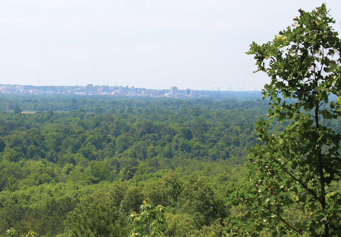
Macon, Georgia, can be seen beyond the forests surrounding Brown’s Mount in Bond Swamp National Wildlife Refuge. Forests cover about two-thirds of the State. Photograph credit: Bill O’Brian, U.S. Fish and Wildlife Service.
Identifying Urban Hotspots
Scientists have been studying the urban heat island effect in Atlanta for decades. Urban heat islands are areas within cities that have more impervious surfaces and fewer natural features, where daytime and nighttime temperatures exceed surrounding areas. These hotspots place vulnerable residents at higher risk for heat-related illnesses or deaths, especially during heat waves. Data from Landsat thermal sensors profile the temperatures of the land’s surface, which can help pinpoint urban heat islands. Landsat also can help indicate where a loss of forest may have resulted in higher temperatures. Central Atlanta Progress, a nonprofit community development organization for downtown Atlanta, and its related Atlanta Downtown Improvement District crafted the “Downtown Atlanta Master Plan” in 2017 as a guide for targeting improvements (Central Atlanta Progress, Inc./Atlanta Downtown Improvement District, 2017). A 2019 technical analysis of sustainability and climate vulnerability, completed to help inform improvements, used Landsat to map downtown heat intensity (Garcia and others, 2019).
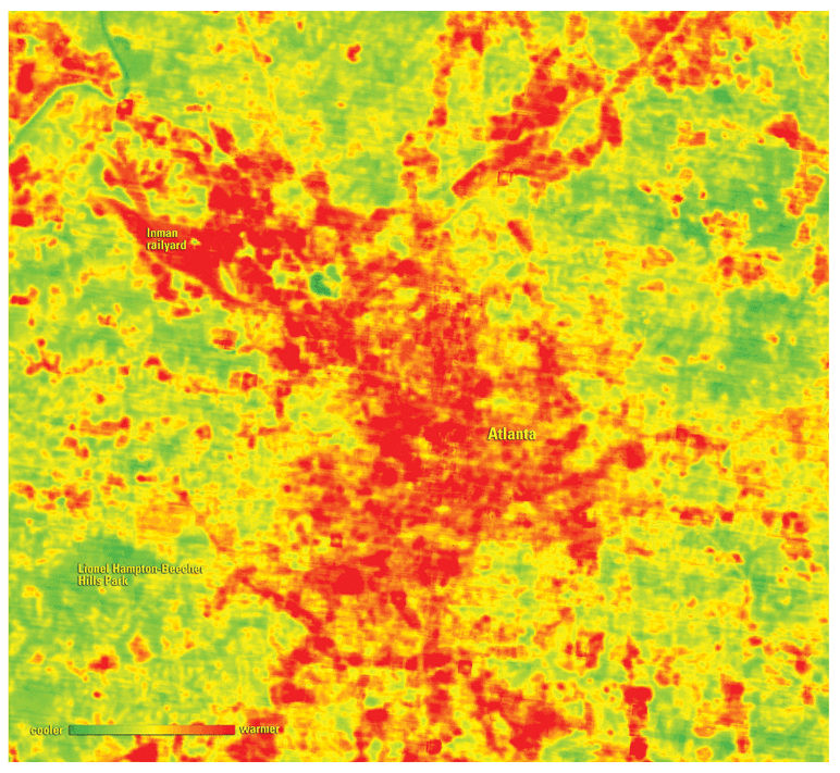
Landsat Surface Temperature satellite products can be used to characterize differences in surface temperature, such as Atlanta, Georgia, shown here. Green represents cooler temperatures; red represents warmer temperatures. Image credit: U.S. Geological Survey.
National Land Imaging Program Benefits—Georgia
The U.S. Geological Survey (USGS) National Land Imaging Program provides a wide range of satellite imagery and other remotely sensed and geospatial data to Government, commercial, academic, and public users. Those users can get worldwide access to Landsat satellite data through the National Land Imaging Program-funded USGS Earth Resources Observation and Science (EROS) Center.
Landsat—Critical Information Infrastructure for the Nation
Landsat is the most widely used land remote sensing data source within Federal civilian agencies. Local, State, Tribal, and Federal agencies use Landsat to monitor and forecast a wide range of land surface phenomena. Information from Landsat contributes to day-to-day decisions on land, water, and resource use that protect life and property; safeguard the environment; advance science, technology, and education; support climate change resiliency; and grow the U.S. economy. Landsat’s imagery provides a landscape-level view of land surface, inland lake, and coastal processes, both natural and human-induced. Landsat enables us to better understand the scope, nature, and speed of change to the natural and built environment.
Businesses draw upon Landsat data to provide customer-specific applications to improve logistics, resource allocation, and investment decisions. Commercial space imaging firms leverage Landsat data to refine product offerings and support new information services. A 2017 USGS study determined the total annual economic benefit of Landsat data in the United States to be $2.06 billion, far surpassing its development and operating costs (Straub and others, 2019).
Landsat 8 and Landsat 9 provide 8-day repeat coverage of the Earth’s land surfaces. The National Aeronautics and Space Administration (NASA) and the USGS are currently reviewing the findings from a joint Architecture Study Team, which will inform the design and implementation approach for Landsat Next, the follow-on mission to Landsat 9. Landsat 9 and its successors are planned to provide a sustainable, space-based system to extend the 50-year Landsat series of high-quality global land imaging measurements—the world’s longest time series of the Earth’s land surface.
The long-term availability of consistent and accurate Landsat data, combined with a no-cost data policy, allows users to analyze extensive geographic areas and better understand and manage long-term trends in land surface change. New cloud computing and data analytics technologies use Landsat data in a wide range of decision-support tools for Government and industry. Much like global positioning systems and weather data, Landsat data are used every day to help us better understand our dynamic planet.
References Cited
Central Atlanta Progress, Inc./Atlanta Downtown Improvement District, 2017, Downtown Atlanta Master Plan: Central Atlanta Progress, Inc./Atlanta Downtown Improvement District report, 342 p., accessed May 18, 2022, at https://www.atlantadowntown.com/_files/downtown-atlanta-master-plan-no-bleeds-for-web-3-30-18-low-res.pdf.
Garcia, J., Zou, N., Anderson, E.G., Bourez, E., Drummonds, K.E., Huber, B., Ludwig, R.L., Mansaray, A., Park, G., Patillo, L.H., Polyakova, K.I., Rafferty, M., and Udell, K.T., 2019, Spatial analysis of sustainability and climate vulnerability in downtown Atlanta: Georgia Institute of Technology, School of City and Regional Planning technical report, 52 p., accessed January 20, 2022, at https://ctycms.com/ga-atlanta/docs/climate-vulnerability-cap-2019-report.pdf.
Georgia Forestry Commission, 2015, Georgia statewide assessment of forest resources: Dry Branch, Ga., Georgia Forestry Commission, 118 p., accessed January 20, 2022, at https://gatrees.org/wp-content/uploads/2020/03/GAStatewideAssessmentofForestResources2015.pdf.
GeorgiaView, 2021, GeorgiaView & AmericaView University: GeorgiaView web page, accessed January 20, 2022, at https://gaview.org/drupal893/.
Straub, C.L., Koontz, S.R., and Loomis, J.B., 2019, Economic valuation of Landsat imagery: U.S. Geological Survey Open-File Report 2019–1112, 13 p., accessed January 13, 2022, at https://doi.org/10.3133/ofr20191112.
For additional information on Landsat, please contact:
Program Coordinator
USGS National Land Imaging Program
12201 Sunrise Valley Drive
Reston, VA 20192
703–648–4567
The Landsat series is a joint effort of USGS and NASA. NASA develops and launches the spacecraft; USGS manages satellite operations, ground reception, data archiving, product generation, and data distribution. Funding for the National Land Imaging Program’s Landsat operations and data management is provided through the USGS.
Disclaimers
Any use of trade, firm, or product names is for descriptive purposes only and does not imply endorsement by the U.S. Government.
Although this information product, for the most part, is in the public domain, it also may contain copyrighted materials as noted in the text. Permission to reproduce copyrighted items must be secured from the copyright owner.
Suggested Citation
U.S. Geological Survey, 2022, Georgia and Landsat (ver. 1.1, March 2025): U.S. Geological Survey Fact Sheet 2022–3039, 2 p., https://doi.org/10.3133/fs20223039.
ISSN: 2327-6932 (online)
ISSN: 2327-6916 (print)
Study Area
| Publication type | Report |
|---|---|
| Publication Subtype | USGS Numbered Series |
| Title | Georgia and Landsat |
| Series title | Fact Sheet |
| Series number | 2022-3039 |
| DOI | 10.3133/fs20223039 |
| Edition | Version 1.0: June 2, 2022; Version 1.1: March 19, 2025 |
| Publication Date | June 02, 2022 |
| Year Published | 2022 |
| Language | English |
| Publisher | U.S. Geological Survey |
| Publisher location | Reston, VA |
| Contributing office(s) | Earth Resources Observation and Science (EROS) Center |
| Description | 2 p. |
| Country | United States |
| State | Georgia |
| Online Only (Y/N) | N |
| Additional Online Files (Y/N) | Y |