
Evaluating the Use of Video Cameras to Estimate Bridge Scour Potential at Four Bridges in Southwestern Montana
Links
- Document: Report (1.83 MB pdf) , HTML , XML
- NGMDB Index Page: National Geologic Map Database Index Page (html)
- Download citation as: RIS | Dublin Core
Using Cameras to Describe Streamflow
Determination of stream velocities is an important component of hydraulic engineering, river ecology, and fluvial geomorphology. Large-scale particle image velocimetry (LSPIV) is an emerging technique that can be used to estimate stream surface velocities and streamflow using video cameras. Video from the camera is referenced to known locations on streambanks, and postprocessed using computer software that calculates water surface velocity and flow direction between video frames. These data can be used to characterize the spatial distribution of hydraulic forces in a stream. The LSPIV technique has been used previously as a real-time method to estimate streamflow, but new analysis methods are being developed to apply the technology to field problems such as indirect streamflow estimates, to stage-based triggers to record and characterize flood events, and as support for other measurement methods (Engel and Koenig, 2018).
From 2019 to 2021, the U.S. Geological Survey (USGS), in cooperation with the Montana Department of Transportation, installed cameras and LSPIV recording equipment at four sites where the USGS and Montana Department of Transportation are monitoring bridge scour using other methods (fig. 1). The goal of the study was to determine if LSPIV can increase the accuracy of current bridge scour prediction methods. Scour around piers is one of the primary failure mechanisms for bridges and threatens public safety and interstate commerce. LSPIV has potential to improve prediction of sediment scour under and around bridge piers during flood events. Traditional methods of bridge scour monitoring such as sounding from bridges and bathymetry during floods are risky and challenging because traditional instrumentation for surveying depths and velocities requires physical access to areas around piers. LSPIV provides noncontact, hourly monitoring of surface velocity and direction. The data generated by LSPIV can be stored or transmitted and could improve safety and estimates of hydraulic forces near bridge piers in real time.
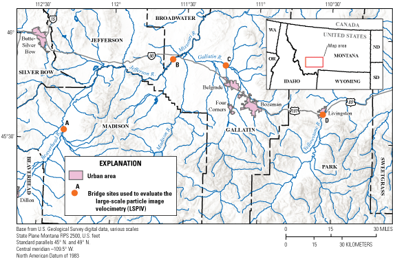
The four bridge sites used to evaluate the LSPIV technique in southwestern Montana. [A denotes Beaverhead River in Twin Bridges, B denotes Jefferson River in Three Forks, C denotes East Gallatin River in Belgrade, and D denotes Yellowstone River in Livingston]
Site Installation and Video Analysis
For this study, video cameras and recording equipment were installed on or near bridges and videos were then stored or transmitted via a cellular modem (fig. 2A, B). The cameras and computers used in this study were small and required low power that could be run from a battery recharged by a solar panel. Reference points along the stream channel within the field of view of the camera were surveyed to generate a scale from which water surface velocities and streamflow could be estimated (fig. 3A–C). Videos are broken into individual frames and the particle-image tracking software is then used to track particle movement between frames. Particle travel distance and time between frames are then used to estimate the magnitude and direction of surface velocities. These methods vary depending on camera orientation, recording dates, and purpose of the experiment (Engel and Koenig, 2018). Cameras also can be mounted in several locations to allow analysis of different locations of interest in the channel (fig. 4).
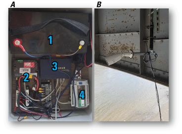
Equipment used for an LSPIV site installation. (A) Recording equipment, including the (1) battery, (2) modem, (3) router, and (4) computer, can be placed in a small, waterproof box that is mounted to the bridge or streambank near the bridge. (B) The weatherproof camera is mounted under the bridge at the site on the Yellowstone River.
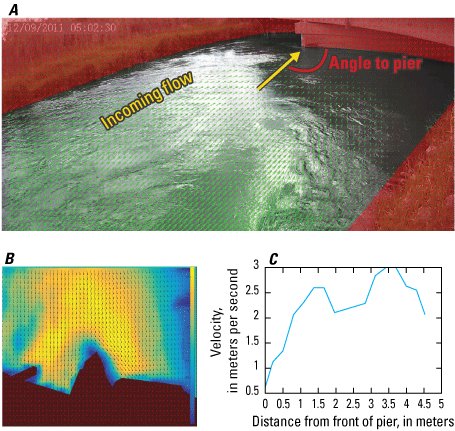
(A) Mounting cameras external to the bridge can provide estimates of the incoming flow velocities and the angle of attack on bridge piers. (B) Interactions between piers and incoming flow velocities can be analyzed in front and to the sides of bridge piers. (C) Velocity profile of incoming flow into the pier. These analyses can be used throughout the hydrograph as velocities and incoming angles change.
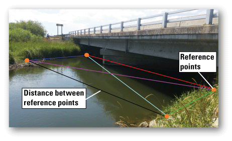
Estimates of streamflow can be calculated using images from cameras mounted on bridges or along the bank. The area of the stream surface from bank to bank must be in frame to calculate the streamflow. Four reference points at the four corners of the rectangle (orange circles) are measured, and the distances between these bank-mounted points (colored lines) are used to calculate the velocity magnitude. The cross-sectional area of the stream can then be used to estimate streamflow.
Evaluation and Limitations of LSPIV
Any method used to measure stream velocity and streamflow has advantages and disadvantages. One goal of this study was to determine the uses and limitations of the LSPIV technique. Some of the biggest benefits of the LSPIV technique were continuous data collection throughout the hydrologic cycle and enhanced safety of the methods for estimating velocity magnitude and direction during flood events. We speculate that bank-mounted cameras could be used to determine the spatial and temporal variability of flow velocities and hydraulic conditions to assist in the design of bridges and bridge piers. Finally, LSPIV installations can capture the flow velocities and directions near bridge piers where other measurement methods might fail or be too dangerous.
Although the LSPIV technique has several benefits, it also has several limitations that need to be overcome. One common limitation of LSPIV software is that velocity magnitudes cannot be determined if the angle is less than 15 degrees from horizontal (Sutarto, 2015). This limitation occurs if the camera is not mounted high enough above the stream. Other limitations of the LSPIV approach include high winds affecting surface velocities, river and bank vegetation limiting the field of view, and highly turbulent areas where flow velocities are spatially inconsistent. The method also is ineffective at night or when ice is covering or limiting the camera’s view of the water surface.
Future applications of the LSPIV technique may incorporate other technology to enhance capabilities and reduce the limitations. Cell phones, for example, could be used to record short videos of flood events at several locations to enhance or verify indirect streamflow calculations. Video recording also can provide information on ice dam formation and jamming, information on channel thalweg migration (fig. 5), and support to streamflow estimates at ungaged sites. Because cameras used for LSPIV analysis are fairly inexpensive, the method also may benefit flood frequency analysis of intermittent, remote, ungaged streams where infrequent, intense storms are the primary runoff mechanism and other methods of recording streamflow are impractical within budgetary constraints.
Long-term monitoring of camera recordings used for LSPIV analyses can indicate the migration of the lowest part of the channel, or thalweg, during and after high-flow events. Monitoring velocity profiles from before and after high-flow events and among years can provide analysts with estimates on where and to what extent the thalweg migrates seasonally and whether or not structures may be in danger.
References Cited
Engel, F., and Koenig, F., 2018, Guidelines for the collection of video for Large Scale Particle Velocimetry (LSPIV): U.S. Geological Survey web page, accessed January 2020 at https://my.usgs.gov/confluence/pages/viewpage.action?pageId=546865360.
Sutarto, T.E., 2015, Application of large scale particle image velocimetry (LSPIV) to identify flow pattern in a channel: Procedia Engineering, v. 125, p. 213–219. [Also available at https://doi.org/10.1016/j.proeng.2015.11.031.]
For more information about this publication, contact:
John Kilpatrick, USGS Wyoming-Montana Water Science Center
3162 Bozeman Avenue
Helena, MT 59601
406–457–5900
For additional information, visit: https://www.usgs.gov/centers/wy-mt-water/
Publishing support provided by the
Rolla and Sacramento Publishing Service Centers
Disclaimers
Any use of trade, firm, or product names is for descriptive purposes only and does not imply endorsement by the U.S. Government.
Although this information product, for the most part, is in the public domain, it also may contain copyrighted materials as noted in the text. Permission to reproduce copyrighted items must be secured from the copyright owner.
Suggested Citation
Armstrong, D.W., Holnbeck, S.R., and Chase, K.J., 2022, Evaluating the use of video cameras to estimate bridge scour potential at four bridges in southwestern Montana: U.S. Geological Survey Fact Sheet 2022–3040, 2 p., https://doi.org/10.3133/fs20223040.
ISSN: 2327-6932 (online)
Study Area
| Publication type | Report |
|---|---|
| Publication Subtype | USGS Numbered Series |
| Title | Evaluating the use of video cameras to estimate bridge scour potential at four bridges in southwestern Montana |
| Series title | Fact Sheet |
| Series number | 2022-3040 |
| DOI | 10.3133/fs20223040 |
| Publication Date | June 22, 2022 |
| Year Published | 2022 |
| Language | English |
| Publisher | U.S. Geological Survey |
| Publisher location | Reston, VA |
| Contributing office(s) | Wyoming-Montana Water Science Center |
| Description | 2 p. |
| Country | United States |
| State | Montana |
| Online Only (Y/N) | Y |