

Arkansas and Landsat
Links
- Document: Report (6.31 MB pdf) , HTML , XML
- Download citation as: RIS | Dublin Core
Abstract
Scenic Arkansas certainly lives up to its nickname, “The Natural State.” The Ozark Plateau and Ouachita Mountains boast stunning views, vast resources, and recreation. Hardwood and pine forests cover one-half of the State. The major rivers—Arkansas, Ouachita, Red, and White—offer recreation and navigation as they drain toward the Mississippi River, which forms the State’s eastern border. Smaller streams and rivers, reservoirs, and rice fields serve as homes for wildlife as well, including birds migrating along the Mississippi Flyway.
Agriculture has always been a key industry in Arkansas, which is the top rice producer in the United States. Poultry, soybeans, cotton, cattle, and timber are among other agricultural products that contribute to the State’s economy. The aquaculture industry has diversified from just goldfish to more than 20 species of fish and crustaceans.
Geological features include waterfalls, limestone caves, and the country’s only active diamond mine, Crater of Diamonds State Park, where visitors can keep any rock or mineral they find in the volcanic crater. Hot Springs National Park—within the city of Hot Springs—features thermal springs of water heated deep belowground that follow a fault line of the Ouachita Mountains up to the surface.
Here are a few ways Landsat has benefited Arkansas.
Monitoring Farm Reservoirs
Irrigation is crucial to agriculture in eastern Arkansas, but groundwater in the Mississippi River alluvial aquifer is being depleted faster than it can be replenished. To help reduce the need for groundwater, hundreds of onfarm reservoirs, or surface water impoundments, have been built in the area to hold rainwater and runoff for use during the dry season; however, an exact number, and their effect on the surrounding environment, has not been clear. More knowledge helps land and water managers make strategic planning decisions. University of Arkansas researchers analyzed 20 years of Landsat data using the USGS Dynamic Surface Water Extent (DSWE) algorithm to determine the increasing number and location of reservoirs in Arkansas County (West and Kovacs, 2018). In a study of eastern Arkansas, U.S. Department of Agriculture and university researchers turned to DSWE and another Landsat-based dataset to characterize reservoir changes over 23 years, including seasonality and variability in temperature and precipitation (Perin and others, 2021).
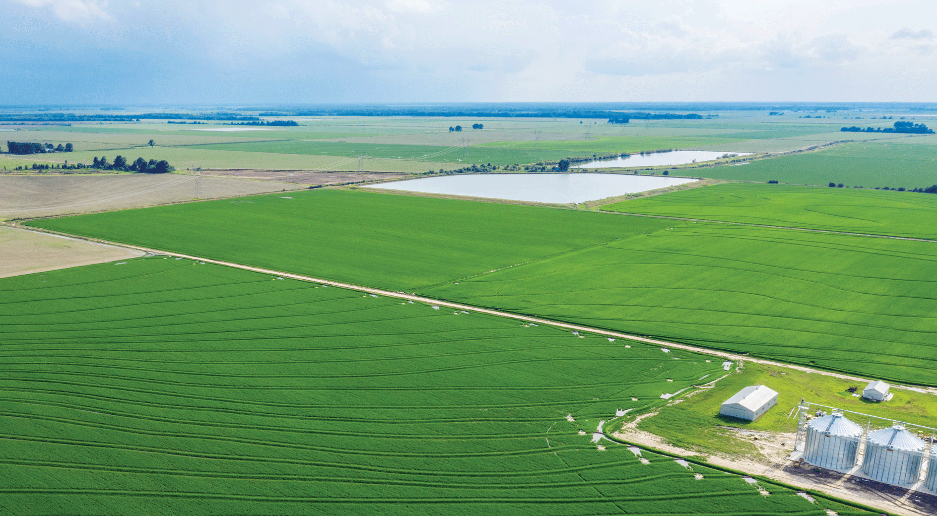
Rice fields in eastern Arkansas with onfarm reservoirs in the background. Photograph credit: Lance Cheung, U.S. Department of Agriculture.
Tracking Crops
Arkansas was one of the few States included in the U.S. Department of Agriculture’s first Cropland Data Layer in 1997. Now, the Cropland Data Layer provides reports for all States on crop type, acreage, and yield based on a foundation of Landsat and other data. The annual data layer reveals what is being planted, how much, and the location, as well as where land use has changed. This information about the food supply helps agricultural producers and others in the industry make prudent land management decisions (U.S. Department of Agriculture, 2022).
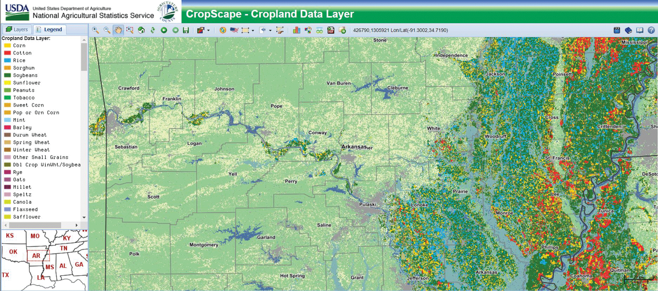
This map of central Arkansas shows forest (darker green) and pasture (lighter green) in the western two-thirds and a cropland mix of rice (bright blue), corn (golden), cotton (red), and soybeans (dark green) in the east. Gray represents developed areas, dark blue represents water, and gray blue represents wetlands. Image credit: U.S. Department of Agriculture, 2021.
Understanding Urban Growth
Northwestern Arkansas, home to the University of Arkansas and headquarters of several large national and international companies, has experienced notable population growth since the mid-1990s. Viewing this growth over time with Landsat imagery can help city officials understand urban development patterns and their effect on the residents and surrounding environment. University of Arkansas researchers used Landsat to assess this area from 1995 to 2015 and to learn the timing and geographic characteristics of the growth patterns (Reynolds and others, 2017).
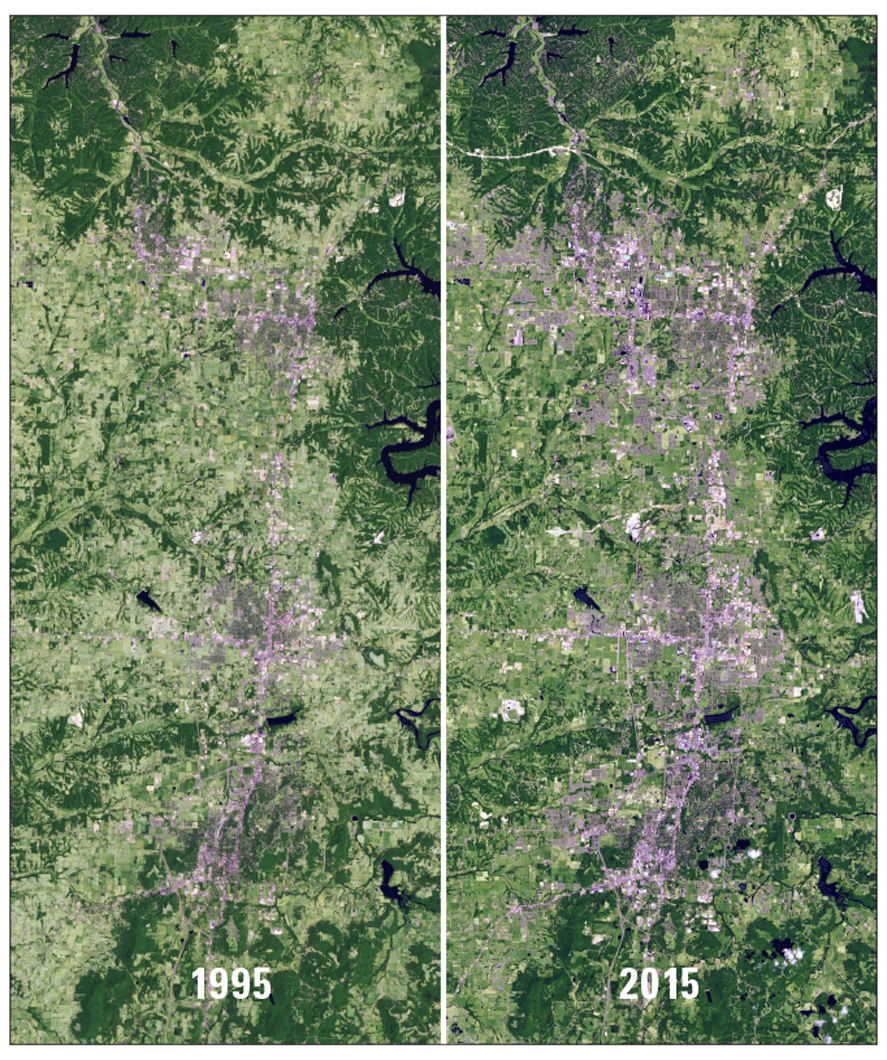
Urban expansion (in gray) is evident in northwestern Arkansas in these Landsat scenes from 1995 and 2015 showing the Bentonville, Springdale, and Fayetteville areas. Image credit: U.S. Geological Survey.
National Land Imaging Program Benefits—Arkansas
The U.S. Geological Survey (USGS) National Land Imaging Program provides a wide range of satellite imagery and other remotely sensed and geospatial data to Government, commercial, academic, and public users. Those users can get worldwide access to Landsat satellite data through the National Land Imaging Program-funded USGS Earth Resources Observation and Science (EROS) Center.
Landsat—Critical Information Infrastructure for the Nation
Landsat is the most widely used land remote sensing data source within Federal civilian agencies. Local, State, Tribal, and Federal agencies use Landsat to monitor and forecast a wide range of land surface phenomena. Information from Landsat contributes to day-to-day decisions on land, water, and resource use that protect life and property; safeguard the environment; advance science, technology, and education; support climate resiliency; and grow the U.S. economy. Landsat’s imagery provides a landscape-level view of land surface, inland lake, and coastal processes, both natural and human-induced. Landsat enables us to better understand the scope, nature, and speed of change to the natural and built environment.
Businesses draw upon Landsat data to provide customer-specific applications to improve logistics, resource allocation, and investment decisions. Commercial space imaging firms leverage Landsat data to refine product offerings and support new information services. A 2017 USGS study determined the total annual economic benefit of Landsat data in the United States. to be $2.06 billion, far surpassing its development and operating costs (Straub and others, 2019).
Landsat 8 and Landsat 9 provide 8-day repeat coverage of the Earth’s land surfaces. The National Aeronautics and Space Administration (NASA) and the USGS are currently reviewing the findings from a joint Architecture Study Team, which will inform the design and implementation approach for Landsat Next, the follow-on mission to Landsat 9. Landsat 9 and its successors are planned to provide a sustainable, space-based system to extend the 50-year Landsat series of high-quality global land imaging measurements—the world’s longest time series of the Earth’s land surface.
The long-term availability of consistent and accurate Landsat data, combined with a no-cost data policy, allows users to analyze extensive geographic areas and better understand and manage long-term trends in land surface change. New cloud computing and data analytics technologies use Landsat data in a wide range of decision-support tools for Government and industry. Much like global positioning systems and weather data, Landsat data are used every day to help us better understand our dynamic planet.
References Cited
Perin, V., Tulbure, M., Gaines, M.D., Reba, M.L., and Yaeger, M.A., 2021, On-farm reservoir monitoring using Landsat inundation datasets: Agricultural Water Management, v. 246, p. 106694, accessed March 10, 2022. https://doi.org/10.1016/j.agwat.2020.106694.
Reynolds, R., Liang, L., Li, X., and Dennis, J., 2017, Monitoring annual urban changes in a rapidly growing portion of northwest Arkansas with a 20-year Landsat record: Remote Sensing, v. 9, no. 71, 17 p., accessed March 11, 2022, at https://digital.library.unt.edu/ark:/67531/metadc1234380/m1/1/.
Straub, C.L., Koontz, S.R., and Loomis, J.B., 2019, Economic valuation of Landsat imagery: U.S. Geological Survey Open-File Report 2019–1112, 13 p., accessed January 13, 2022, at https://doi.org/10.3133/ofr20191112.
U.S. Department of Agriculture, 2021, CropScape—Cropland Data Layer: U.S. Department of Agriculture, National Agriculture Statistics Service digital data, accessed March 11, 2022, at https://nassgeodata.gmu.edu/CropScape/.
U.S. Department of Agriculture, 2022, CropScape and Cropland Data Layers—FAQs: U.S. Department of Agriculture, National Agricultural Statistics Service web page, accessed March 11, 2022, at https://www.nass.usda.gov/Research_and_Science/Cropland/sarsfaqs2.php#Section3_17.0.
West, G., and Kovacs, K., 2018, Tracking the growth of on-site irrigation infrastructure in the Arkansas Delta with remote sensing analysis: Arkansas Bulletin of Water Research, 8 p., accessed March 11, 2022, at https://agcomm.uark.edu/awrc/publications/bulletin/Issue-2018-Kovacs-and-West-Growth-of-onsite-irrigation-infrastructure-in-Arkansas-delta.pdf.
For additional information on Landsat please contact:
Program Coordinator
USGS National Land Imaging Program
12201 Sunrise Valley Drive
Reston, VA 20192
703–648–4567
The Landsat series is a joint effort of USGS and NASA. NASA develops and launches the spacecraft; USGS manages satellite operations, ground reception, data archiving, product generation, and data distribution. Funding for the National Land Imaging Program’s Landsat operations and data management is provided through the USGS.
Disclaimers
Any use of trade, firm, or product names is for descriptive purposes only and does not imply endorsement by the U.S. Government.
Although this information product, for the most part, is in the public domain, it also may contain copyrighted materials as noted in the text. Permission to reproduce copyrighted items must be secured from the copyright owner.
Suggested Citation
U.S. Geological Survey, 2022, Arkansas and Landsat: U.S. Geological Survey Fact Sheet 2022–3042, 2 p., https://doi.org/10.3133/fs20223042.
ISSN: 2327-6932 (online)
ISSN: 2327-6916 (print)
Study Area
| Publication type | Report |
|---|---|
| Publication Subtype | USGS Numbered Series |
| Title | Arkansas and Landsat |
| Series title | Fact Sheet |
| Series number | 2022-3042 |
| DOI | 10.3133/fs20223042 |
| Publication Date | June 14, 2022 |
| Year Published | 2022 |
| Language | English |
| Publisher | U.S. Geological Survey |
| Publisher location | Reston, VA |
| Contributing office(s) | Earth Resources Observation and Science (EROS) Center |
| Description | 2 p. |
| Country | United States |
| State | Arkansas |
| Online Only (Y/N) | N |