Comparison of Water Year 2021 Streamflow to Historical Data at Selected Sites in the Snake River Basin, Wyoming
Links
- Document: Report (6.29 MB pdf) , HTML , XML
- Download citation as: RIS | Dublin Core
Abstract
The headwaters of the Snake River are in the mountains of northwestern Wyoming on lands primarily administered by the National Park Service and the Bridger-Teton National Forest. Streamflow in the Snake River Basin has been measured at some sites for more than 100 years (U.S. Geological Survey, 2021). Water from this drainage basin is used for recreation, agriculture, municipal supply, and power generation. Comparison of streamflows in the basin in water year 2021 with historical data can increase understanding of how these multiple uses, along with the ongoing drought in the Western United States, affect water availability during different times of the year (U.S. Department of Agriculture, 2022). Historical streamflow data are defined as the operational period of the streamgage through water year 2020. A water year is named for the year in which it ends; therefore, water year 2021 is October 1, 2020, through September 30, 2021.

Snake River above Reservoir, near Alpine, Wyoming (station number 13022500), is located 100 miles downstream from the headwaters site of Leidy Creek at mouth, near Moran, Wyoming (station number 13012465). The annual streamflow at Snake River above Reservoir, near Alpine, Wyoming, is about 700 times the annual streamflow in Leidy Creek. Photograph by Jerrod D. Wheeler, July 15, 2020.
Streamflow Data Collected in the Snake River Basin
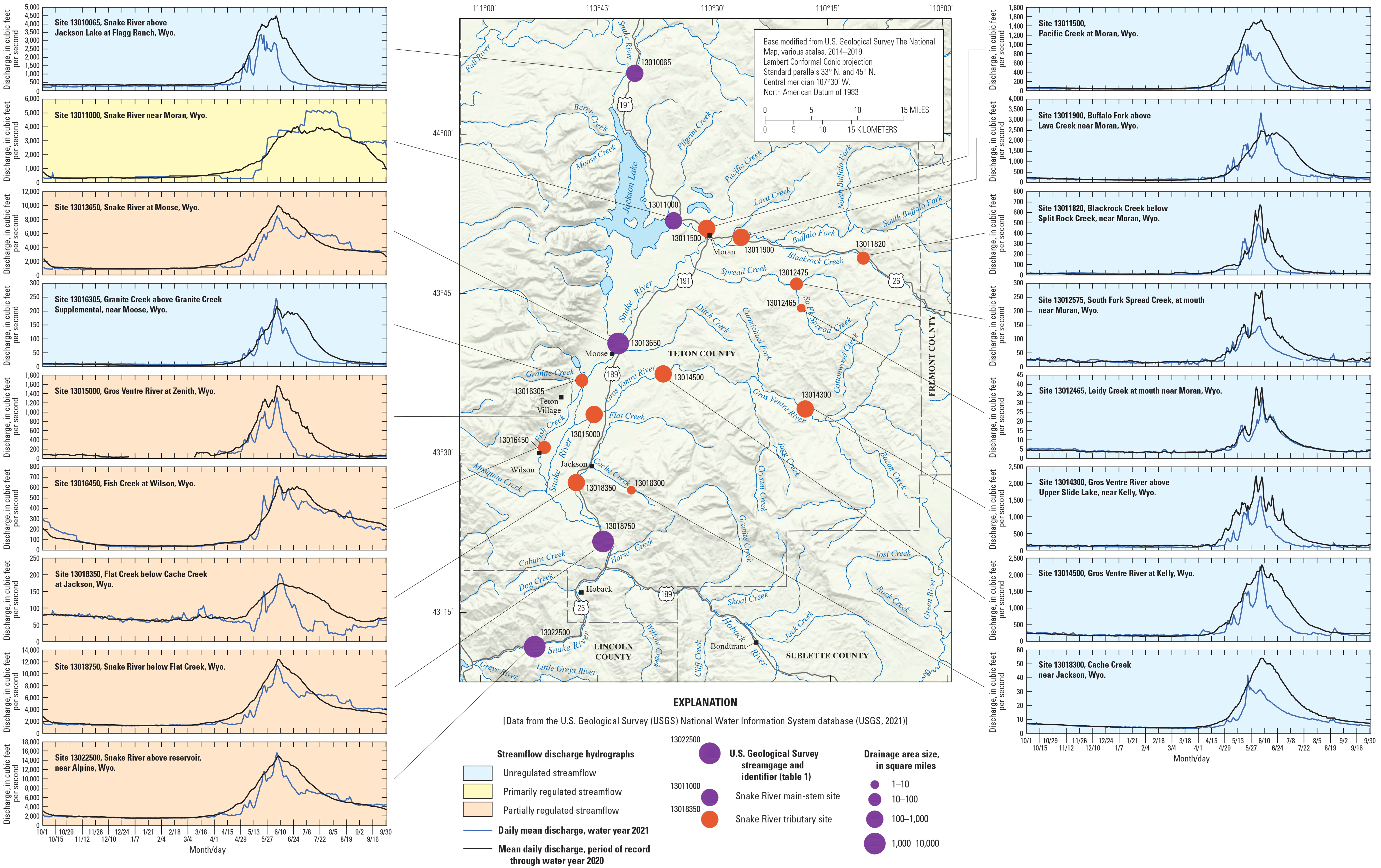
Sixteen streamgages were in year-round operation and one streamgage was operated from April 1 to September 30 during water year 2021 at sites on the main stem of the Snake River and its tributaries (table 1, fig. 1) (U.S. Geological Survey, 2021). The streamgages recorded streamflow at sites with drainage areas ranging from 5.13 square miles in the tributary Leidy Creek (station number 13012465; table 1) to 3,465 square miles on the main-stem Snake River, just upstream from Palisades Reservoir (station number 13022500; table 1) (U.S. Geological Survey, 2021). Streamflow in the Snake River in Wyoming is primarily a result of snowmelt runoff that typically begins in May and continues through July, depending on the area and elevation of the watershed upstream from the streamgage. Additionally, streamflow is regulated by dams and diversions at the more downstream sites (table 1) in the basin, which modifies natural streamflow patterns by storing and releasing water to meet downstream water needs.
Table 1.
U.S. Geological Survey streamgages in operation during water year 2021 in the Snake River Basin upstream from Palisades Reservoir, Idaho (U.S. Geological Survey, 2021).[mi2, square mile]

The rapid melting of snow quickly creates high flows in South Fork Spread Creek at mouth, near Moran, Wyoming (station number 13012475). Photograph by Cheryl Eddy-Miller, June 23, 2020.

Sixteen streamgages were in year-round operation and one streamgage was operated from April 1 to September 30 during water year 2021 in the Snake River Basin. Streamflow at each site was dependent on the drainage area and the timing of snowmelt, as well as upstream water regulation (U.S. Geological Survey, 2021).
Streamflow from water year 2021 at each site was compared graphically (fig. 1) to the streamflow for the period of record that predates the 2021 water year (historical data) (U.S. Geological Survey, 2021). The water year 2021 data are the daily mean streamflow at that site (fig. 1). The historical data are the mean daily streamflow (mean of all the daily means for the period of record through water year 2020) (U.S. Geological Survey, 2021). The daily mean and mean daily streamflow data are useful for observing the timing of streamflow and how large the flows are each day.
Comparison of Streamflow During Water Year 2021 to Historical Data
Cumulative streamflow is useful to determine the total amount of streamflow that flowed past each site during the entire month or each season and was calculated at each site using the daily streamflow data (table 2) (U.S. Geological Survey, 2021). Annual streamflow during water year 2021 tended to be lower than historical annual streamflow for the period of record through the 2020 water year (U.S. Geological Survey, 2021). At unregulated sites, the annual streamflow during water year 2021 ranged from 49 to 78 percent of the historical mean annual streamflow for the period of record through the 2020 water year (table 2). At sites with some level of regulation (table 2), the streamflow during water year 2021 ranged from 79 to 113 percent of the historical mean annual streamflow for the period of record through the 2020 water year (U.S. Geological Survey, 2021).
Table 2.
Annual streamflow during water year 2021 and period of record through water year 2020 at U.S. Geological Survey streamgages, Snake River Basin (U.S. Geological Survey, 2021).[Mcf, million cubic feet; POR, period of record; NA, not applicable]
Snowmelt runoff began near the same time of year at most unregulated sites when comparing the increase in streamflow in the spring of water year 2021 to the historical spring streamflow increase. At most unregulated sites, the peak snowmelt streamflow for water year 2021 occurred near the same time as historical flows, but the duration of the peak flows was shorter in 2021, with streamflow dropping to base flow, or low flow, conditions in midsummer. Peak streamflows at sites that were primarily regulated or partially regulated were similar to unregulated sites, but the decrease in flow after the peak and base flow tended to resemble historical streamflow in magnitude and timing (U.S. Geological Survey, 2021).

Streamflow in Leidy Creek at mouth, near Moran, Wyoming (station number 13012465), located in the mountainous headwater of Snake River Basin is relatively consistent throughout the winter months owing to base flow as the area snowpack accumulates. Photograph by Jerrod D. Wheeler, February 23, 2020.

Snake River near Moran, Wyoming (station number 13011000), monitors regulated streamflow releases from the Jackson Lake Dam. Photograph by James R. Campbell, November 20, 2020.
Streamflow at unregulated sites indicates that the snowmelt runoff in April, May, and June typically accounts for more than 50 percent of the annual flow (table 2). Streamflow during the same 3 months, at sites with year-round data collection that are regulated or partially regulated, is less than 50 percent of the annual flow, which indicates the effect of storing the water from spring runoff. At most sites, regardless of the amount of regulation, during water year 2021 the percentage of annual streamflow during April, May, and June was similar to the percentage during the historical period of record (table 2) (U.S. Geological Survey, 2021).
References Cited
U.S. Department of Agriculture, 2022, Drought in the Western United States: U.S. Department of Agriculture Economic Research Service, accessed February 2, 2022, at https://www.ers.usda.gov/newsroom/trending-topics/drought-in-the-western-united-states/#:~:text=According%20to%20the%20U.S.%20Drought,experiencing%20e xtreme%20or%20exceptional%20drought.&text=Drought%20conditions%20began%20in%20the,the%20first%20months%20of%202021.
U.S. Geological Survey, 2021, USGS water data for the Nation: U.S. Geological Survey National Water Information System database, accessed December 6, 2021, at https://doi.org/10.5066/F7P55KJN.
For more information about this publication, contact:
Director, USGS Wyoming-Montana Water Science Center
521 Progress Circle, Suite 6
Cheyenne, WY 82007
307–775–9162
For additional information, visit: https://www.usgs.gov/centers/wy-mt-water/
Publishing support provided by the
Rolla Publishing Service Center
Disclaimers
Any use of trade, firm, or product names is for descriptive purposes only and does not imply endorsement by the U.S. Government.
Although this information product, for the most part, is in the public domain, it also may contain copyrighted materials as noted in the text. Permission to reproduce copyrighted items must be secured from the copyright owner.
Suggested Citation
Law, R.M., Campbell, J.R., Wheeler, J.D., and Eddy-Miller, C.E., 2022, Comparison of water year 2021 streamflow to historical data at selected sites in the Snake River Basin, Wyoming: U.S. Geological Survey Fact Sheet 2022–3043, 5 p., https://doi.org/10.3133/fs20223043.
ISSN: 2327-6932 (online)
Study Area
| Publication type | Report |
|---|---|
| Publication Subtype | USGS Numbered Series |
| Title | Comparison of water year 2021 streamflow to historical data at selected sites in the Snake River Basin, Wyoming |
| Series title | Fact Sheet |
| Series number | 2022-3043 |
| DOI | 10.3133/fs20223043 |
| Publication Date | June 27, 2022 |
| Year Published | 2022 |
| Language | English |
| Publisher | U.S. Geological Survey |
| Publisher location | Reston, VA |
| Contributing office(s) | Wyoming-Montana Water Science Center |
| Description | 5 p. |
| Country | United States |
| State | Wyoming |
| Other Geospatial | Snake River Basin |
| Online Only (Y/N) | Y |


