

U.S. Geological Survey Colorado River Basin Actionable and Strategic Integrated Science and Technology (ASIST)—Information Management Technology Plan
Links
- Document: Report (1.26 MB pdf) , HTML , XML
- Related Work: USGS Fact Sheet 2022-3010— Addressing Stakeholder Science Needs for Integrated Drought Science in the Colorado River Basin Fact Sheet 2022-3010
- Download citation as: RIS | Dublin Core
Introduction
More than 840 publications, 575 data releases, and 330 project web pages from the U.S. Geological Survey (USGS) pertain to the Colorado River Basin. Limited interconnections between Colorado River Basin publications, data, and web pages restrict the ability to synthesize and interpret scientific resources. Currently, these pieces are spread across multiple isolated locations, internal systems, data repositories, and local offices. The increasing size, complexity, and diversity of Colorado River Basin data creates additional need for integration. These different data types—including discrete, continuous, aerial, remote sensing, geophysical, geospatial, and other types in varied formats—are collected over numerous time and space scales and require data-intensive science and technology to integrate.
Information management technology (IMT) resources are enterprise capabilities that the USGS workforce can leverage at multiple scales with consistent interoperable solutions to better facilitate integrated science. The USGS 21st Century Science Strategy (USGS, 2021) directs the USGS to establish enterprise IMT capabilities that support integrated work through interoperable software and database solutions at multiple scales. This Information Management Technology Plan identifies nine steps (fig. 1) to leverage new and existing technologies, data, models, and scientific knowledge to support integrated science projects conducted across the Colorado River Basin. These steps are transferable to integrated-science studies in other locations.

Information management technology planning and implementation phases. (USGS, U.S. Geological Survey; IMT, information management technology).
Planning Phase (FY 2021)
In fiscal year (FY) 2021, the Data Management and Advanced Technology subgroup of the ASIST project worked towards developing an IMT plan that includes several advanced IMT solutions that are currently being implemented Bureau-wide by the Office of the Associate Chief Information Officer. This plan identifies applications, opportunities, and steps to leverage new and existing technologies, data, models, and knowledge to support integrated science projects conducted across the Colorado River Basin.
Step 1—Document Relevant Resources and Seek Input Through Collaboration
The major outcome from the project planning phase, which the Colorado River Basin ASIST project team and USGS science-support organizations completed in FY 2021, is an initial technology framework to support interdisciplinary drought-science collaborations (table 1). This framework, further augmented by discussions at Science and Technology Collaboration Meetings, includes the following:
-
• Identify science and technology applications in the Colorado River Basin, relevant resources, existing USGS expertise and capabilities, and knowledge gaps.
-
• Provide opportunities through short-term use cases to connect USGS researchers and seek input through collaboration with members of the scientific community working on similar topics.
-
• Discuss strategies and actions to connect with enterprise tools to support new integrated science and technology approaches for the Colorado River Basin.
The next steps to integrating data and models focus on evaluating technology to streamline connections across use cases and partners.
Table 1.
A list of U.S. Geological Survey enterprise Information Management Technology Resources available in the Colorado River Basin.Step 2—Conduct Short-Term Use Cases and Connect with Enterprise Tools
The Colorado River Basin ASIST project also worked with a wide variety of short-term use cases focused on drought in the Colorado River Basin to review current and potential applications of IMT to support integrated science and deliver actionable information (fig. 2).
The short-term use cases funded by the Colorado River Basin ASIST project combine multiple science disciplines and focus on key elements of the USGS IMT application strategy, including the following goals:
-
• Develop efficient workflows to address computational, storage, analytical and visualization needs related to science problems.
-
• Apply technology, such as artificial intelligence and machine learning, to improve access to USGS and partner observation systems.
-
• Monitor progress towards improving network security, policies, and capacity.
-
• Work with science-support organizations to quantify improved efficiency of the data hub, workflows between USGS and its partner workflows, and other process improvements.
-
• Finalize a roadmap to use the full spectrum of USGS IMT resources available to support integrated science.
-
• Leverage Internet of Things or edge computing, artificial intelligence, machine learning, high-performance computing, and other new technologies where applicable.
-
• Continue aligning with communities of practice for technical support and workforce training.
The continued advancement of science and services depends on remaining agile and adopting new technologies as they become available.
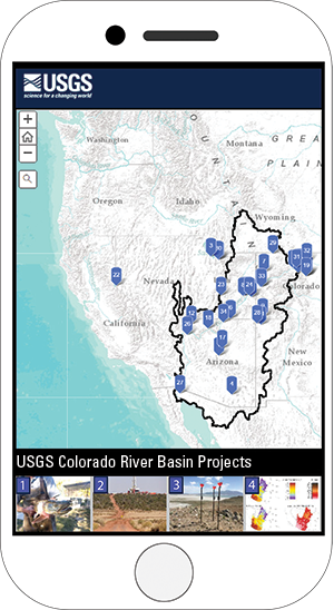
Map of the western United States showing short-term use case locations as blue pins (above), with thumbnails of four use cases (below). The map is available at https://apps.usgs.gov/colorado-river-basin/integrated-drought-science.html, along with more information on each use case.
Implementation Phase (FY 2022 to FY 2026)
The Information Management Technology Plan for the Colorado River Basin ASIST project builds support capacity for integrated science in the Colorado River Basin over a 4-year period. The plan builds this capacity by first developing a technology framework, then expanding to non-USGS data and further refining the framework, and finally delivering actionable USGS science.
Step 3—Develop Technology Framework
Develop technology framework and workflows, and test technology applications with integrated science projects in the basin
Step 4—Expand to Non-USGS Data
Expand integrated science testing of technology to non-USGS data, models, systems, and partners, and incorporate these processes into the technology framework
Step 5—Refine Framework
Refine interim technology framework with USGS information technology leads, science-support organizations, and national communities of practice
-
• Complete a data hub with established enterprise datasets and connect trusted science repositories and partner datasets in the basin.
-
• Work with science-support organizations to quantify improved efficiency of the data hub, workflows between the USGS and its partners, and other process improvements.
Step 6—Finalize Framework
Finalize technology framework and coproduce science delivery tools with partners and stakeholders
Step 7—Deliver Actionable USGS Science
Deliver actionable USGS science through interoperable frameworks and capabilities
-
• Document best practices for publishing and sharing integrated products, leveraging visualization technologies to present outcomes from multiple disciplines, and deliver actionable science to stakeholders.
All activities from 2022 through 2026 focus on building support to implement IMT at multiple scales with consistent interoperable solutions for the community of scientists working on integrated science efforts in the Colorado River Basin.
Reference Cited
U.S. Geological Survey, 2021, U.S. Geological Survey 21st-Century Science Strategy 2020–2030: U.S. Geological Survey Circular 1476, 20 p., accessed August 12, 2021, at https://doi.org/10.3133/cir1476.
Disclaimers
Any use of trade, firm, or product names is for descriptive purposes only and does not imply endorsement by the U.S. Government.
Although this information product, for the most part, is in the public domain, it also may contain copyrighted materials as noted in the text. Permission to reproduce copyrighted items must be secured from the copyright owner.
Suggested Citation
Anderson, E.D, Erxleben, J.R., Qi, S.L., Monroe, A.P., and Dahm, K.G., 2022, U.S. Geological Survey Colorado River Basin Actionable and Strategic Integrated Science and Technology (ASIST)—Information Management Technology Plan: U.S. Geological Survey Fact Sheet 2022-3051, 4 p., https://doi.org/10.3133/fs20223051.
ISSN: 2327-6932 (online)
Study Area
| Publication type | Report |
|---|---|
| Publication Subtype | USGS Numbered Series |
| Title | U.S. Geological Survey Colorado River Basin Actionable and Strategic Integrated Science and Technology (ASIST)—Information Management Technology Plan |
| Series title | Fact Sheet |
| Series number | 2022-3051 |
| DOI | 10.3133/fs20223051 |
| Publication Date | November 29, 2022 |
| Year Published | 2022 |
| Language | English |
| Publisher | U.S. Geological Survey |
| Publisher location | Reston, VA |
| Contributing office(s) | Fort Collins Science Center, Oregon Water Science Center, Rocky Mountain Region Director’s Office |
| Description | 4 p. |
| Country | United States |
| State | Arizona, Colorado, Nevada, New Mexico, Utah, Wyoming |
| Other Geospatial | Colorado River Basin |
| Online Only (Y/N) | Y |