

North Dakota and Landsat
Links
- Document: Report (3.83 MB pdf) , HTML , XML
- Download citation as: RIS | Dublin Core
Abstract
The State of North Dakota once did not figure prominently in the Nation’s economy. The sparsely populated State supported food production, and hunters and anglers were drawn to its lakes, rivers, and wide-open spaces, but its economy was overshadowed by that of other States. However, the State and its prairie expanses recently rocketed from an economic afterthought to a national energy leader with the soaring production of oil and natural gas in the Bakken oil patch.
The Bakken development has been transformative for North Dakota’s landscapes in myriad ways. It has boosted economic output, drawn thousands of new residents to cities like Williston and Watford City, and led to a proliferation of oil and gas pads.
In the past two decades, North Dakota experienced other major changes, such as the expansion of the depressional wetlands of the Prairie Pothole Region on the eastern side of the State. These critical breeding areas for waterfowl, which stretch across Minnesota, South Dakota, North Dakota, and Canada, are home to more than 50 percent of North America’s migratory birds (U.S. Environmental Protection Agency, 2021).
Changes from oil and gas production, urban development, and wetland resurgence can all be tracked over time using the unparalleled Earth observation record of the USGS Landsat data archive. Its 50-year record of repeat imagery also aids in the monitoring, cataloging, and management of cropland, invasive insect species, and natural or human-made disaster recovery. Here are just a few examples of the benefits offered to North Dakota by the Landsat Program.
Tracking Changes from Energy Development
The Landsat archive can be used to compare how a changing area’s landscapes appeared 50 years ago to how they look today, but the depth of the satellite record offers value beyond illustrative comparisons. The National Land Cover Database (NLCD) sorts each 30-meter plot of land in the United States into land cover classes, such as wetlands or cultivated crops, and releases coast-to-coast updates every 2–3 years. The NLCD also includes secondary data layers of surface features such as impervious urban surfaces and tree canopy cover. The two most recent NLCD releases include a layer that maps oil and gas pads across the United States (Dewitz and U.S. Geological Survey, 2021). Powered by Landsat, researchers can track the extensive landscape changes and urban growth that have accompanied the surge in energy development across North Dakota. Such efforts, in turn, can inform urban planning and land management at the State and local levels.
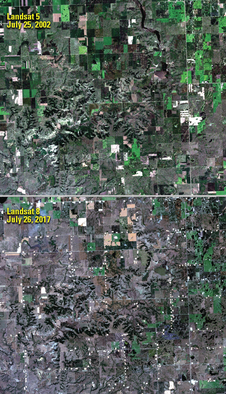
Landsat images from (top) July 25, 2002, and (bottom) July 26, 2017, show the emergence of well pads in North Dakota’s Bakken oil patch. Image credits: U.S. Geological Survey.
Monitoring Crops from Above
North Dakota maintains a strong agricultural heritage, and agricultural production accounted for more than $7.3 billion in revenue in 2020, which, along with agricultural processing, amounted to 7.6 percent of the State’s total gross domestic product (University of Arkansas, 2022). North Dakota’s agricultural output features a diverse group of crops. In 2020, North Dakota led the Nation in the production of all dry edible beans, pinto beans, canola, flaxseed, honey, rye, all sunflower, and all wheat (U.S. Department of Agriculture, 2021). Landsat data are a key input for the U.S. Department of Agriculture’s Cropland Data Layer, which maps crop types year by year across the lower 48 States; however, Landsat’s value to agriculture goes beyond crop type mapping. The data can be used to monitor crop health at broad scales because they go beyond visible light and record infrared and near-infrared energy. Landsat thermal sensors also can be used to calculate water use efficiency through estimates of evapotranspiration, which is the combined rate of evaporation from the Earth’s surface and transpiration from plant leaves.
Watching Over Wetlands
North Dakota’s wetlands serve as critical habitat for migratory birds and double as a draw for recreation. These dynamic areas undergo frequent change, shrinking in some areas as seasonal wetlands are drained for crop production and growing in others. High-resolution aerial surveys can be used to map wetland extent, but these surveys are too costly to repeat frequently. Landsat’s long-term repeat observations of North Dakota’s wetlands enable researchers to not only map changes to wetland extent year by year but also to monitor trends within each year, track trends over time, delineate ephemeral lakes from permanent ones, and model future changes (Rover and others, 2011; Vanderhoof and others, 2017).
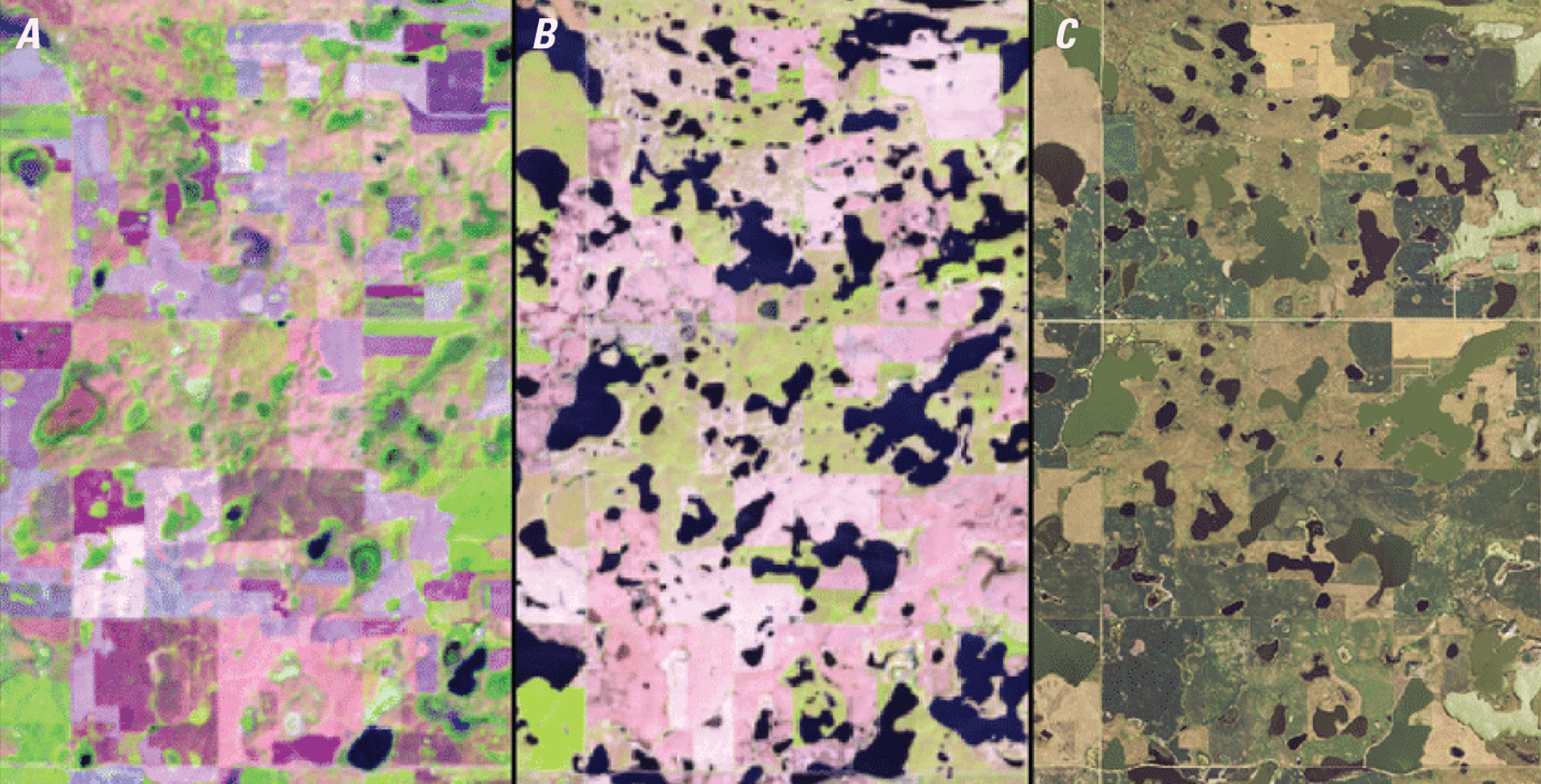
Landsat imagery and a National Agriculture Imagery Program (NAIP) aerial photograph of the same area in Stutsman County, North Dakota, show the dynamic nature of prairie pothole wetlands in (A) dry and (B and C) wet conditions. The satellite data were acquired on September 2, 1992, and May 23, 2013. The (C) NAIP data were collected in 2012. Image credits: (left and center) U.S. Geological Survey and (right) NAIP.
National Land Imaging Program Benefits—North Dakota
The U.S. Geological Survey (USGS) National Land Imaging Program provides a wide range of satellite imagery and other remotely sensed and geospatial data to Government, commercial, academic, and public users. Those users can get worldwide access to Landsat satellite data through the National Land Imaging Program-funded USGS Earth Resources Observation and Science (EROS) Center.
Landsat—Critical Information Infrastructure for the Nation
Landsat is the most widely used land remote sensing data source within Federal civilian agencies. Local, State, Tribal, and Federal agencies use Landsat to monitor and forecast a wide range of land surface phenomena. Information from Landsat contributes to day-to-day decisions on land, water, and resource use that protect life and property; safeguard the environment; advance science, technology, and education; support climate resiliency; and grow the U.S. economy. Landsat’s imagery provides a landscape-level view of land surface, inland lake, and coastal processes, both natural and human-induced. Landsat enables us to better understand the scope, nature, and speed of change to the natural and built environment.
Businesses draw upon Landsat data to provide customer-specific applications to improve logistics, resource allocation, and investment decisions. Commercial space imaging firms leverage Landsat data to refine product offerings and support new information services. A 2017 USGS study determined the total annual economic benefit of Landsat data in the United States. to be $2.06 billion, far surpassing its development and operating costs (Straub and others, 2019).
Landsat 8 and Landsat 9 provide 8-day repeat coverage of the Earth’s land surfaces. The National Aeronautics and Space Administration (NASA) and the USGS are currently reviewing the findings from a joint Architecture Study Team, which will inform the design and implementation approach for Landsat Next, the follow-on mission to Landsat 9. Landsat 9 and its successors are planned to provide a sustainable, space-based system to extend the 50-year Landsat series of high-quality global land imaging measurements—the world’s longest time series of the Earth’s land surface.
The long-term availability of consistent and accurate Landsat data, combined with a no-cost data policy, allows users to analyze extensive geographic areas and better understand and manage long-term trends in land surface change. New cloud computing and data analytics technologies use Landsat data in a wide range of decision-support tools for Government and industry. Much like global positioning systems and weather data, Landsat data are used every day to help us better understand our dynamic planet.
References Cited
Dewitz, J., and U.S. Geological Survey, 2021, National Land Cover Database (NLCD) 2019 Products (ver. 2.0, June 2021): U.S. Geological Survey data release, accessed July 17, 2022, at https://doi.org/10.5066/P9KZCM54.
Rover, J., Wright, C.K., Euliss, N.H., Jr., Mushet, D.M., and Wylie, B.K., 2011, Classifying the hydrologic function of prairie potholes with remote sensing and GIS: Wetlands, v. 31, p. 319–327. [Also available at https://doi.org/10.1007/s13157-011-0146-y.]
Straub, C.L., Koontz, S.R., and Loomis, J.B., 2019, Economic valuation of Landsat imagery: U.S. Geological Survey Open-File Report 2019–1112, 13 p., accessed January 4, 2022, at https://doi.org/10.3133/ofr20191112.
University of Arkansas, 2022, Economic impact of agriculture—North Dakota: University of Arkansas Division of Agriculture web page, accessed July 17, 2022, at https://economic-impact-of-ag.uada.edu/north-dakota/#:~:text=In%202020%2C%20North%20Dakota%20generated,percent%20of%20total%20state%20GDP.
U.S. Department of Agriculture, 2021, North Dakota Agriculture—Ag Statistics No. 90: U.S. Department of Agriculture National Agricultural Statistics Service report, accessed July 17, 2022, at https://www.nass.usda.gov/Statistics_by_State/North_Dakota/Publications/Annual_Statistical_Bulletin/2021/ND-Annual-Bulletin21.pdf.
U.S. Environmental Protection Agency, 2021, Prairie potholes: U.S. Environmental Protection Agency web page, accessed January 11, 2022, at https://www.epa.gov/wetlands/prairie-potholes.
Vanderhoof, M.K., Christensen, J.R., and Alexander, L.C., 2017, Patterns and drivers for wetland connections in the Prairie Pothole Region, United States: Wetlands Ecology and Management, v. 25, no. 3, p. 275–297. [Also available at https://doi.org/10.1007/s11273-016-9516-9.]
For additional information on Landsat, please contact:
Program Coordinator
USGS National Land Imaging Program
12201 Sunrise Valley Drive
Reston, VA 20192
703–648–4567
The Landsat series is a joint effort of USGS and NASA. NASA develops and launches the spacecraft; USGS manages satellite operations, ground reception, data archiving, product generation, and data distribution. Funding for the National Land Imaging Program’s Landsat operations and data management is provided through the USGS.
Disclaimers
Any use of trade, firm, or product names is for descriptive purposes only and does not imply endorsement by the U.S. Government.
Although this information product, for the most part, is in the public domain, it also may contain copyrighted materials as noted in the text. Permission to reproduce copyrighted items must be secured from the copyright owner.
Suggested Citation
U.S. Geological Survey, 2022, North Dakota and Landsat: U.S. Geological Survey Fact Sheet 2022–3053, 2 p., https://doi.org/10.3133/fs20223053.
ISSN: 2327-6932 (online)
ISSN: 2327-6916 (print)
Study Area
| Publication type | Report |
|---|---|
| Publication Subtype | USGS Numbered Series |
| Title | North Dakota and Landsat |
| Series title | Fact Sheet |
| Series number | 2022-3053 |
| DOI | 10.3133/fs20223053 |
| Publication Date | July 19, 2022 |
| Year Published | 2022 |
| Language | English |
| Publisher | U.S. Geological Survey |
| Publisher location | Reston, VA |
| Contributing office(s) | Earth Resources Observation and Science (EROS) Center |
| Description | 2 p. |
| Country | United States |
| State | North Dakota |
| Online Only (Y/N) | N |