
Kansas and Landsat
Links
- Document: Report (10.8 MB pdf) , HTML , XML
- Download citation as: RIS | Dublin Core
Abstract
Kansas seems synonymous with agriculture, and rightly so—87 percent of Kansas land is devoted to it (Kansas Department of Agriculture, 2016a). As a key contributor to the State’s economy, agriculture makes Kansas one of the top producers of wheat, grain sorghum, and cattle in the country, but the State at the geographic center of the conterminous United States contains much more than fields and pastures.
Deciduous woodlands sprawl throughout the east. Tallgrass prairie—the only extensive stand remaining in the country—covers the east-central Flint Hills with more than 500 species of plants, many of them wildflowers, including the Sunflower State’s nickname inspiration. Near the center of Kansas, Cheyenne Bottoms—the largest marsh in the interior United States at 41,000 acres—welcomes migrating birds, including the endangered Grus americana (Linnaeus, 1758; whooping crane), by the thousands in the spring and fall. To the south, the inland saltwater marshes of Quivira National Wildlife Refuge attract many more.
Farther west, chalk outcroppings like Castle Rock and Monument Rocks rise above the landscape as fossil-bearing remnants of a sea floor from millions of years ago. Oil and natural gas fields exist throughout the State. After two University of Kansas professors discovered helium in a sample from one natural gas well in 1905, Kansas became a substantial supplier. The Landsat Program provides tools for monitoring and managing our conservation lands and their many resources. Here are several ways Landsat helps Kansas.
Observing Vegetation and Crops
With its scale and historical archive, Landsat excels at observing changes to vegetation. The Kansas Applied Remote Sensing Program of the Kansas Biological Survey, established by NASA and the State of Kansas, created 1990, 2005, and 2015 statewide Land Cover Patterns maps from Landsat data for the study of landscape change over time (Peterson and Egbert, 2017). From the first satellite launch, a key goal for agriculturalists has been to monitor crop production. Landsat data underpin the annual U.S. Department of Agriculture Cropland Data Layer (CDL) that shows crop-specific land cover nationwide. The CDL reveals what crops are being planted, where, and to what extent to provide basic information about the food supply and land management. The CDL came in handy for a recent study about the first year of the addition of industrial hemp to Kansas agriculture. An investigation of hemp-growing locations revealed that 60 percent of hemp fields had replaced pasture or other undeveloped, uncultivated land, resulting in an overall increase in the amount of cultivated land (Ebert and others, 2020).
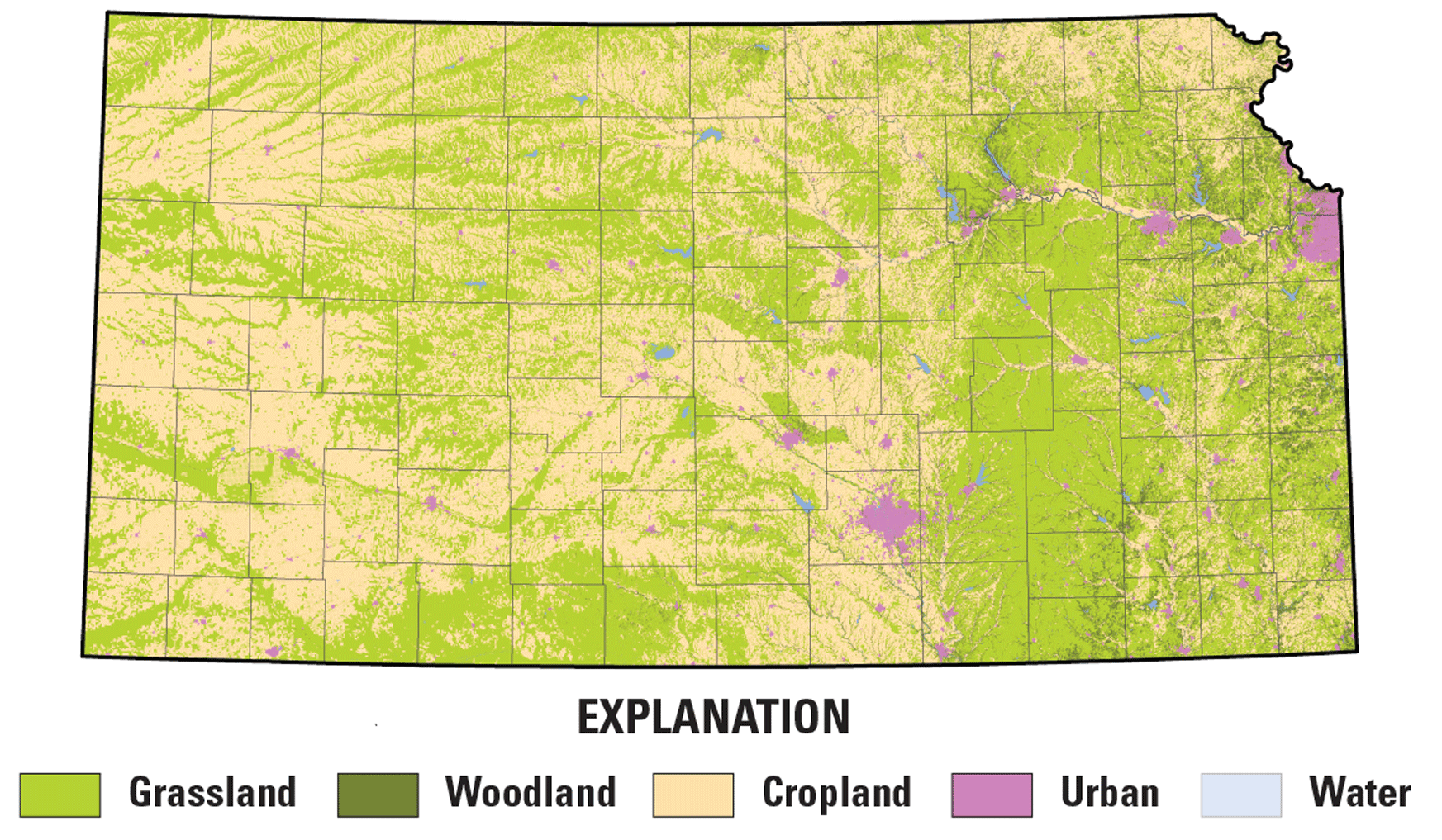
The 2015 Kansas Land Cover Patterns map, developed on a foundation of Landsat data. Image credit: Kansas Applied Remote Sensing at the University of Kansas; used with permission.
Monitoring Water Use
Irrigation accounts for an average of 85 percent of Kansas’ consumptive water use (Kansas Department of Agriculture, 2016b). Water from the High Plains, or Ogallala, aquifer, which underlies parts of Kansas and seven other States, has helped bolster agriculture in western Kansas for generations; however, as groundwater levels drop faster than the aquifer can recharge, concerns have risen about its long-term viability. Landsat can serve as one tool to monitor and manage water use. Irrigation and water resource managers also benefit from knowing the amount of water consumed. Landsat’s thermal data help model how much water is used in irrigation by measuring evapotranspiration, the movement of water into the atmosphere via evaporation and plant transpiration. USGS EROS Center scientists used evapotranspiration to help determine the pattern of water use and overall water balance for croplands across Kansas that rely on either irrigation or precipitation (Ji and others, 2021).
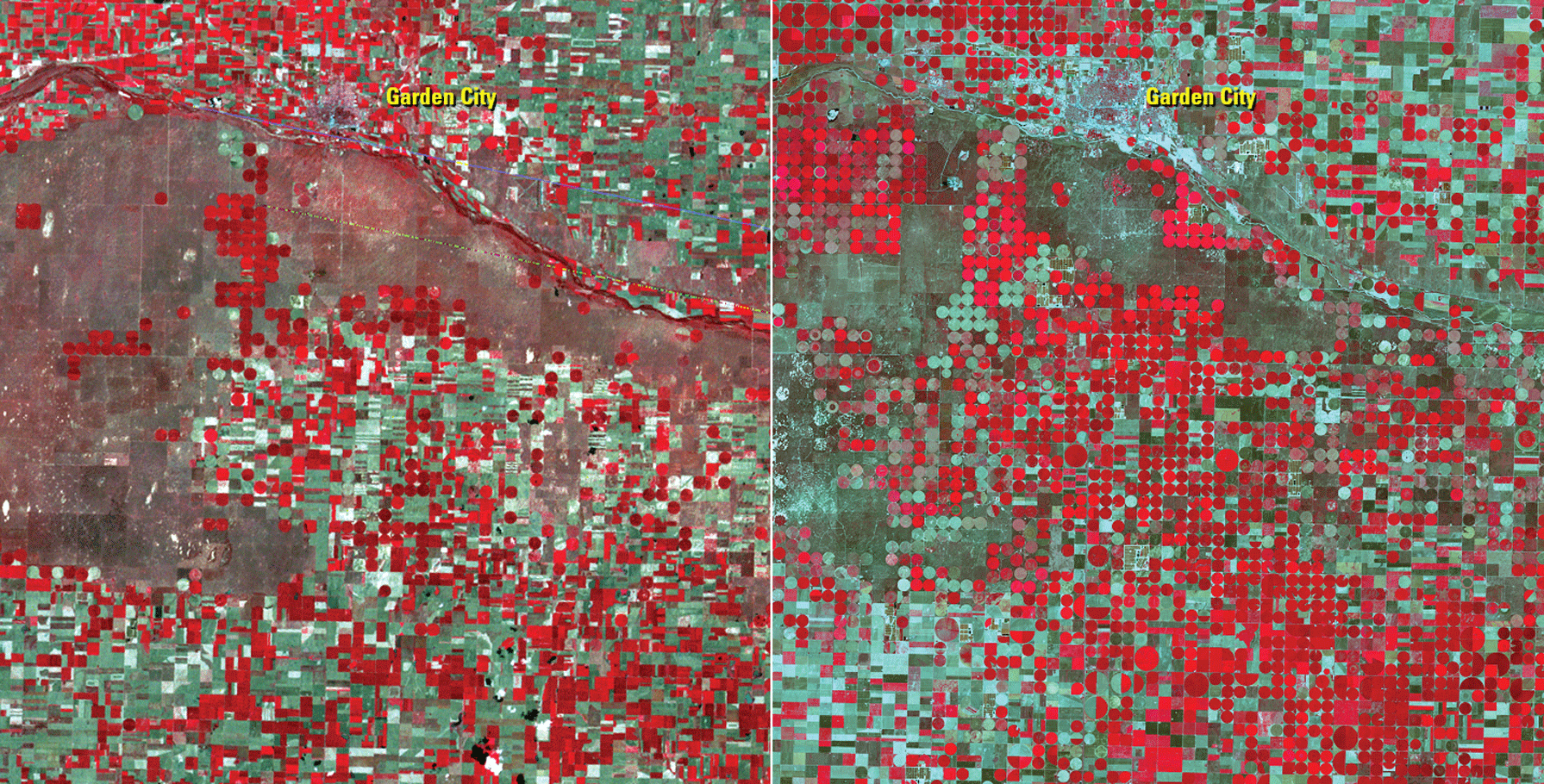
These Landsat false-color images show the growth of center-pivot irrigation (shown as red circles) around Garden City in southwestern Kansas between August 16, 1972 (left), and August 26, 2021 (right). The irrigation water is drawn from the High Plains aquifer. Image credits: U.S. Geological Survey.
Tracking Forest Trends
Juniperus virginiana L. (eastern redcedar [ERC]), is native to the United States and can be useful for windbreaks, but fire suppression has allowed it to thrive and spread into areas it once did not, such as grasslands and deciduous forests. This encroachment can transform habitats and displace birds and wildlife. Highly flammable ERC also can increase the risk of wildfires. To determine how much ERC expanded in oak-dominant deciduous forests in Kansas from 1986 to 2017, researchers at Kansas State University turned to Landsat’s reliably continuous record and spectral bands. Observations of ERC at times when deciduous trees were dormant revealed substantial ERC encroachment over time in three study areas, a finding that could help land managers and property owners target treatments and reduce the risk of wildfire (Pabodha Galgamuwa and others, 2020).
National Land Imaging Program Benefits—Kansas
The U.S. Geological Survey (USGS) National Land Imaging Program provides a wide range of satellite imagery and other remotely sensed and geospatial data to Government, commercial, academic, and public users. Those users can get worldwide access to Landsat satellite data through the National Land Imaging Program-funded USGS Earth Resources Observation and Science (EROS) Center.
Landsat—Critical Information Infrastructure for the Nation
Landsat is the most widely used land remote sensing data source within Federal civilian agencies. Local, State, Tribal, and Federal agencies use Landsat to monitor and forecast a wide range of land surface phenomena. Information from Landsat contributes to day-to-day decisions on land, water, and resource use that protect life and property; safeguard the environment; advance science, technology, and education; support climate change resiliency; and grow the U.S. economy. Landsat’s imagery provides a landscape-level view of land surface, inland lake, and coastal processes, both natural and human-induced. Landsat enables us to better understand the scope, nature, and speed of change to the natural and built environment.
Businesses draw upon Landsat data to provide customer-specific applications to improve logistics, resource allocation, and investment decisions. Commercial space imaging firms leverage Landsat data to refine product offerings and support new information services. A 2017 USGS study determined the total annual economic benefit of Landsat data in the United States. to be $2.06 billion, far surpassing its development and operating costs (Straub and others, 2019).
Landsat 8 and Landsat 9 provide 8-day repeat coverage of the Earth’s land surfaces. The National Aeronautics and Space Administration (NASA) and the USGS are currently reviewing the findings from a joint Architecture Study Team, which will inform the design and implementation approach for Landsat Next, the follow-on mission to Landsat 9. Landsat 9 and its successors are planned to provide a sustainable, space-based system to extend the 50-year Landsat series of high-quality global land imaging measurements—the world’s longest time series of the Earth’s land surface.
The long-term availability of consistent and accurate Landsat data, combined with a no-cost data policy, allows users to analyze extensive geographic areas and better understand and manage long-term trends in land surface change. New cloud computing and data analytics technologies use Landsat data in a wide range of decision-support tools for Government and industry. Much like global positioning systems and weather data, Landsat data are used every day to help us better understand our dynamic planet.
References Cited
Ebert, K., Hoch, B., Taylor, H., and Schwab, B., 2020, From the ground up—A look at Kansas’ first year of industrial hemp production: Western Economics Forum, v. 18, no. 2, p. 15–23, accessed February 17, 2022, at https://ageconsearch.umn.edu/record/308111.
Ji, L., Senay, G.B., Friedrichs, M., Schauer, M., and Boiko, O., 2021, Characterization of water use and water balance for the croplands of Kansas using satellite, climate, and irrigation data: Agricultural Water Management, v. 256, art. 107106, 16 p., accessed February 17, 2022, at https://www.sciencedirect.com/science/article/pii/S0378377421003711.
Kansas Department of Agriculture, 2016a, Kansas agriculture: Kansas Department of Agriculture web page, accessed July 18, 2022, at https://agriculture.ks.gov/about-kda/kansas-agriculture.
Kansas Department of Agriculture, 2016b, Water use reporting: Kansas Department of Agriculture web page, accessed June 24, 2022, at https://agriculture.ks.gov/divisions-programs/dwr/water-appropriation/water-use-reporting.
Pabodha Galgamuwa, G.A., Wang, J., and Barden, C., 2020, Expansion of eastern redcedar (Juniperus virginiana L.) into the deciduous woodlands within the forest-prairie ecotone of Kansas: Forests, v. 11, no. 2, 19 p., accessed February 17, 2022, at https://www.mdpi.com/1999-4907/11/2/154/htm.
Peterson, D.L., and Egbert, S.E., 2017, 2015 Kansas Land Cover Patterns phase I—Final report: Kansas Biological Survey, University of Kansas, 19 p., accessed July 18, 2022, at https://data.kansasgis.org/dascweb/docs/files/866KLCP2015PhaseIFinalReport.pdf.
Straub, C.L., Koontz, S.R., and Loomis, J.B., 2019, Economic valuation of Landsat imagery: U.S. Geological Survey Open-File Report 2019–1112, 13 p., accessed January 13, 2022, at https://doi.org/10.3133/ofr20191112.
For additional information on Landsat, please contact:
Program Coordinator
USGS National Land Imaging Program
12201 Sunrise Valley Drive
Reston, VA 20192
703–648–4567
The Landsat series is a joint effort of USGS and NASA. NASA develops and launches the spacecraft; USGS manages satellite operations, ground reception, data archiving, product generation, and data distribution. Funding for the National Land Imaging Program’s Landsat operations and data management is provided through the USGS.
Disclaimers
Any use of trade, firm, or product names is for descriptive purposes only and does not imply endorsement by the U.S. Government.
Although this information product, for the most part, is in the public domain, it also may contain copyrighted materials as noted in the text. Permission to reproduce copyrighted items must be secured from the copyright owner.
Suggested Citation
U.S. Geological Survey, 2022, Kansas and Landsat: U.S. Geological Survey Fact Sheet 2022–3057, 2 p., https://doi.org/10.3133/fs20223057.
ISSN: 2327-6932 (online)
ISSN: 2327-6916 (print)
Study Area
| Publication type | Report |
|---|---|
| Publication Subtype | USGS Numbered Series |
| Title | Kansas and Landsat |
| Series title | Fact Sheet |
| Series number | 2022-3057 |
| DOI | 10.3133/fs20223057 |
| Publication Date | July 20, 2022 |
| Year Published | 2022 |
| Language | English |
| Publisher | U.S. Geological Survey |
| Publisher location | Reston, VA |
| Contributing office(s) | Earth Resources Observation and Science (EROS) Center |
| Description | 2 p. |
| Country | United States |
| State | Kansas |
| Online Only (Y/N) | N |