

New Hampshire and Landsat
Links
- Document: Report (4.59 MB pdf) , HTML , XML
- Download citation as: RIS | Dublin Core
Abstract
At its widest point, a mere 80 miles separate the eastern and western borders of New Hampshire. Its northern and southern borders are just 175 miles apart. Even so, few States can boast as much rugged natural beauty per mile as the Nation’s fifth smallest.
Nestled within New Hampshire are 93 State parks teeming with moose, Ursus americanus (Pallas, 1780; black bears), coyotes, beavers, river otters, and foxes. The largest section of White Mountain National Forest cuts across north-central New Hampshire, drawing visitors to its lakes, streams, mountain peaks, and hardwood forests. New Hampshire also is home to Lake Winnipesaukee, the State’s largest lake, notable for its floating post offices, the annual “ice-out” contest that sees residents vying to guess the date its surface ice dissipates, and its supporting role in films such as “On Golden Pond” and “What About Bob?” However, the scenic forests of New Hampshire face challenges in the form of invasive species such as Lymantria dispar (Linnaeus, 1758; spongy moth), Adelges piceae (balsam woolly adelgid), and Agrilus planipennis (emerald ash borer). In recent years, New Hampshire’s lakes and streams have seen more cyanobacterial blooms as well.
The USGS Landsat Program offers a consistent, reliable, and historically unmatched source of Earth observations that can aid in the mapping, monitoring, and management of New Hampshire’s land and water resources. Here are a few ways Landsat data have been used in the Granite State.
Monitoring Water Quality
In freshwater lakes, an overabundance of nutrients can create a host of problems for humans and wildlife. Beyond foul odors or the unpleasant appearance of algae caused by this eutrophication is the serious threat of cyanobacterial blooms, which can endanger human health. New Hampshire has traditionally relied on a network of volunteers to collect and submit water samples to monitor the presence of indicative phytoplankton concentrations, but Landsat imagery also can offer a low-cost supplemental source of water quality information. Because Landsat satellites collect information beyond the visible range with high sensitivity, Landsat data can detect the presence of chlorophyll a, which is a measure of algal growth. One study from 2018 determined that Landsat 8 measurements of chlorophyll a aligned closely with on-the-ground measurements in several New Hampshire lakes. These observations offer a less time- and labor-intensive option for water quality monitoring (Boucher and others, 2018).
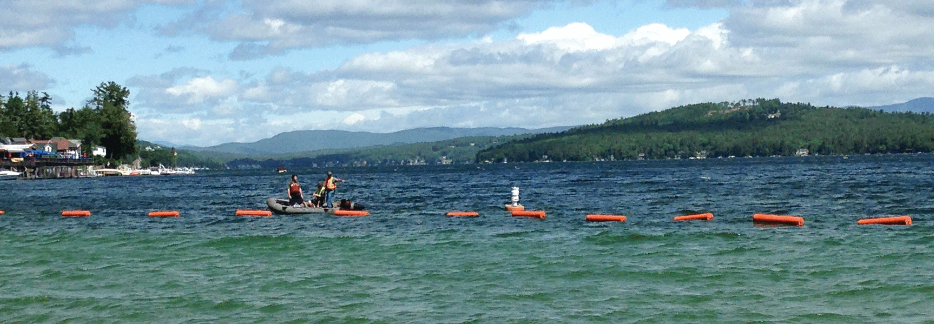
In June 2016, U.S. Geological Survey scientists deployed a new high-tech buoy that helps determine when the water is safe for swimming at popular Weirs Beach on New Hampshire's Lake Winnipesaukee. Landsat imagery sensors can aid in water quality monitoring by detecting harmful algal blooms at wide scales and aiding in targeted mitigation efforts. Photograph credit: Richard Kiah, U.S. Geological Survey.
A Watchful Eye on Forests
Nearly 80 percent of New Hampshire is forested, making it second only to Maine for forested area coverage. In a sense, then, the health of New Hampshire’s forests provides a surrogate measurement for the State’s landscape health as a whole. With its steady repeat observations of the Earth’s surface and 30-meter resolution—each pixel is about the size of a baseball infield—Landsat imagery is uniquely well suited for the study of forest change. Researchers have used Landsat data to note the slow creep of conifers into lower elevation areas of the State’s White Mountains (Vogelmann and others, 2012) and to measure the forests’ net primary productivity—the amount of carbon absorbed by trees minus carbon lost through respiration (Potter and others, 2007). Such information can aid New Hampshire’s forest management discussions and decision making.
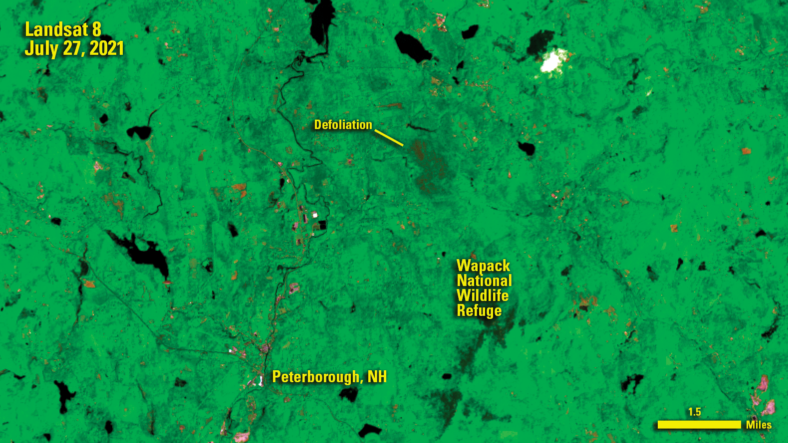
Landsat sensors can peer beyond visible light into the near-infrared and shortwave infrared parts of the electromagnetic spectrum, allowing researchers and land managers to tease out damage to forests, such as the defoliation seen in this 2021 scene, acquired amid a summer in New Hampshire during which the invasive Lymantria dispar (Linnaeus, 1758; spongy moth) reemerged as a threat to the State’s forests.
Mapping Land Use, Land Cover
Landsat is foundational to national-scale land cover and land use mapping projects such as the National Land Cover Database or the National Oceanic and Atmospheric Administration Coastal Change Analysis Program. Such data can serve as a starting point for State and local authorities to measure and model the effect of changes to urban areas, wetlands, coastlines, forests, or grasslands. In 2017, geographers with the University of New Hampshire’s Earth Systems Research Center modeled six scenario-based possibilities for changes to the State’s landscapes from 2010 to 2100 (Thorn and others, 2017). The models offer guidance on the potential effect of development and environmental policies for State and local decision makers.
National Land Imaging Program Benefits—New Hampshire
The U.S. Geological Survey (USGS) National Land Imaging Program provides a wide range of satellite imagery and other remotely sensed and geospatial data to Government, commercial, academic, and public users. Those users can get worldwide access to Landsat satellite data through the National Land Imaging Program-funded USGS Earth Resources Observation and Science (EROS) Center.
Landsat—Critical Information Infrastructure for the Nation
Landsat is the most widely used land remote sensing data source within Federal civilian agencies. Local, State, Tribal, and Federal agencies use Landsat to monitor and forecast a wide range of land surface phenomena. Information from Landsat contributes to day-to-day decisions on land, water, and resource use that protect life and property; safeguard the environment; advance science, technology, and education; support climate change resiliency; and grow the U.S. economy. Landsat’s imagery provides a landscape-level view of land surface, inland lake, and coastal processes, both natural and human-induced. Landsat enables us to better understand the scope, nature, and speed of change to the natural and built environment.
Businesses draw upon Landsat data to provide customer-specific applications to improve logistics, resource allocation, and investment decisions. Commercial space imaging firms leverage Landsat data to refine product offerings and support new information services. A 2017 USGS study determined the total annual economic benefit of Landsat data in the United States. to be $2.06 billion, far surpassing its development and operating costs (Straub and others, 2019).
Landsat 8 and Landsat 9 provide 8-day repeat coverage of the Earth’s land surfaces. The National Aeronautics and Space Administration (NASA) and the USGS are currently reviewing the findings from a joint Architecture Study Team, which will inform the design and implementation approach for Landsat Next, the follow-on mission to Landsat 9. Landsat 9 and its successors are planned to provide a sustainable, space-based system to extend the 50-year Landsat series of high-quality global land imaging measurements—the world’s longest time series of the Earth’s land surface.
The long-term availability of consistent and accurate Landsat data, combined with a no-cost data policy, allows users to analyze extensive geographic areas and better understand and manage long-term trends in land surface change. New cloud computing and data analytics technologies use Landsat data in a wide range of decision-support tools for Government and industry. Much like global positioning systems and weather data, Landsat data are used every day to help us better understand our dynamic planet.
References Cited
Boucher, J., Weathers, K.C., Norouzi, H., and Steele, B., 2018, Assessing the effectiveness of Landsat 8 chlorophyll a retrieval algorithms for regional freshwater monitoring: Ecological Applications, v. 28, no. 4, p. 1044–1054. [Also available at https://doi.org/10.1002/eap.1708.]
Potter, C., Gross, P., Genovese, V., and Smith, M.-L., 2007, Net primary productivity of forest stands in New Hampshire estimated from Landsat and MODIS satellite data: Carbon Balance and Management, v. 2, no. 1, art. 9, 11 p., accessed July 19, 2022, at https://doi.org/10.1186/1750-0680-2-9.
Straub, C.L., Koontz, S.R., and Loomis, J.B., 2019, Economic valuation of Landsat imagery: U.S. Geological Survey Open-File Report 2019–1112, 13 p., accessed January 13, 2022, at https://doi.org/10.3133/ofr20191112.
Thorn, A.M., Wake, C.P., Grimm, C.D., Mitchell, C.R., Mineau, M.M., and Ollinger, S.V., 2017, Development of scenarios for land cover, population density, impervious cover, and conservation in New Hampshire, 2010–2100: Ecology and Society, v. 22, no. 4, art. 19, 29 p., accessed July 19, 2022, at https://doi.org/10.5751/ES-09733-220419.
Vogelmann, J.E., Xian, G., Homer, C., and Tolk, B., 2012, Monitoring gradual ecosystem change using Landsat time series analyses—Case studies in selected forest and rangeland ecosystems: Remote Sensing of Environment, v. 122, p. 92–105. [Also available at https://doi.org/10.1016/j.rse.2011.06.027.]
For additional information on Landsat, please contact:
Program Coordinator
USGS National Land Imaging Program
12201 Sunrise Valley Drive
Reston, VA 20192
703–648–4567
The Landsat series is a joint effort of USGS and NASA. NASA develops and launches the spacecraft; USGS manages satellite operations, ground reception, data archiving, product generation, and data distribution. Funding for the National Land Imaging Program’s Landsat operations and data management is provided through the USGS.
Disclaimers
Any use of trade, firm, or product names is for descriptive purposes only and does not imply endorsement by the U.S. Government.
Although this information product, for the most part, is in the public domain, it also may contain copyrighted materials as noted in the text. Permission to reproduce copyrighted items must be secured from the copyright owner.
Suggested Citation
U.S. Geological Survey, 2022, New Hampshire and Landsat: U.S. Geological Survey Fact Sheet 2022–3058, 2 p., https://doi.org/10.3133/fs20223058.
ISSN: 2327-6932 (online)
ISSN: 2327-6916 (print)
Study Area
| Publication type | Report |
|---|---|
| Publication Subtype | USGS Numbered Series |
| Title | New Hampshire and Landsat |
| Series title | Fact Sheet |
| Series number | 2022-3058 |
| DOI | 10.3133/fs20223058 |
| Publication Date | July 20, 2022 |
| Year Published | 2022 |
| Language | English |
| Publisher | U.S. Geological Survey |
| Publisher location | Reston, VA |
| Contributing office(s) | Earth Resources Observation and Science (EROS) Center |
| Description | 2 p. |
| Country | United States |
| State | New Hampshire |
| Online Only (Y/N) | N |