

The National Cooperative Geologic Mapping Program’s U.S. GeoFramework Initiative: Delivering a digital database of geologic map information by 2030
Links
- Document: Report (996 kB pdf) , HTML , XML
- Download citation as: RIS | Dublin Core
Purpose of the U.S. GeoFramework Initiative
Surface (2D) and subsurface (3D) geologic data are critical for resource management, infrastructure design, hazards characterization, and basic earth science research. To meet these needs in a digital landscape, geologic maps must transition from static publications to machine-readable and discoverable digital databases that enable spatial analyses and queries. The U.S. Geological Survey (USGS) National Cooperative Geologic Mapping Program’s (NCGMP) U.S. GeoFramework Initiative (USGI) responds to the Congressional direction (U.S. Congress, House Committee on Appropriations, 2019) to implement the National Geologic Map Database (NGMDB) Phase Three. The USGI aims to create and deliver a new digital geologic framework of the United States by 2030. Constructing the USGI requires the involvement of various partners and stakeholders—most prominently State Geological Surveys.
The USGI will leverage geologic mapping by State Geological Surveys and the USGS to populate a distributed database of geologic map information and to construct a new geologic map and 3D model of the United States, providing geologic syntheses and supporting digital databases to enable 21st century applications of geologic maps. The USGI will encourage multi-disciplinary scientific discovery and informed decision making. The resulting USGI products will contribute flexible and data-driven solutions to a breadth of earth science problems, including drinking water protection, hazard identification (for example, 3D fault mapping), infrastructure design, natural resource management, and climate change resilience (for example, supporting reservoir characterization for geologic carbon sequestration).
Who is building the U.S. GeoFramework?
Federal scientists, State Geological Surveys, and academic institutions will all contribute to building the 2D and 3D GeoFramework (fig. 1). At the Federal level, USGI activities are conducted within two core projects—the National Geologic Map Database Project (NGMDB) and the National Geologic Synthesis (NGS) Project—and numerous supporting projects as needed. State Geological Surveys will contribute to the 2D and 3D activities of the GeoFramework via expanded opportunities within the NCGMP’s STATEMAP Program. Academic Institutions can contribute towards the USGI via the EDMAP Program, which strives to train the next generation of geologic mappers.
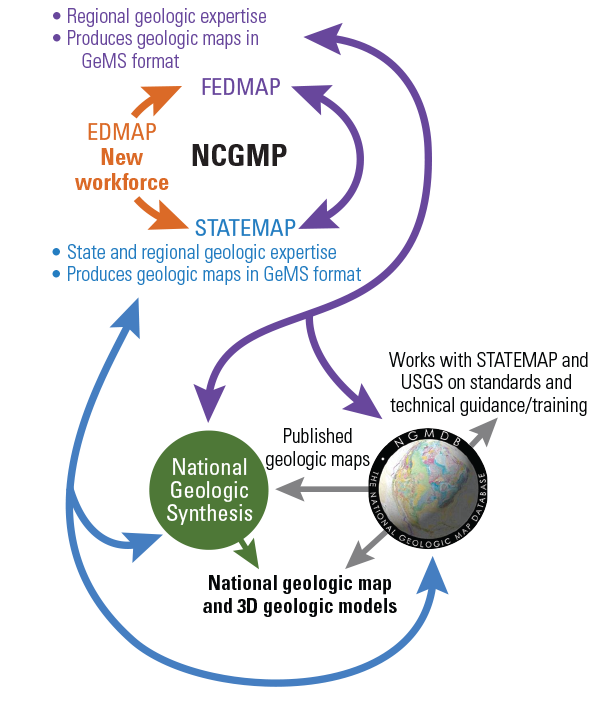
Schematic of U.S. GeoFramework Initiative Cooperators. (GeMS, Geologic Map Schema; NCGMP, National Cooperative Geologic Mapping Program ; 3D, three dimensional)
The National Geologic Map Database (NGMDB)
TheUSGI greatly benefits from the long-standing presence of the NGMDB, a “national archive” of geoscience information established in 1995. This archive provides: (i) a comprehensive collection of geoscience publications and map data; (ii) various web interfaces for query and display of the data catalog; (iii) the U.S. Geologic Names Lexicon (Geolex); and (iv) a standards development program. The NGMDB also serves a foundational role in support of the USGI by: (i) expanding its data catalog to include subsurface maps and 3D-relevant data; (ii) helping to develop standards and digital geologic map schemas required to build the 2D and 3D national GeoFramework; and (iii) providing technical guidance and training to the geologic mapping community. The NGMDB catalog of published geologic maps (https://ngmdb.usgs.gov/ngmdb/ngmdb_home.html) serves as the starting point in inventorying existing data and the repository for digital map data produced by Federal and State Geological Survey scientists.
The National Geologic Synthesis Project (NGS)
The USGI established the NGS to assemble and deliver a new geologic map and 3D model of the United States. The NGS will work with State Geological Surveys to determine the most appropriate datasets from each state to both provide complete national geologic map coverage by the end of the decade, and to coordinate data synthesis at continental and national levels of resolution. Geologic data will be assembled in queryable databases and served to the public, with updates as new data are produced by the USGS and the State Geological Surveys. The NGS project will also contribute to the development of data standards and common working practices.
U. S. GeoFramework Initiative Supporting Projects
As needs for new mapping and 3D data are identified, USGI supporting projects will be developed to fill the needs of the 2D/3D national GeoFramework, working in close collaboration with NCGMP. These will be smaller, shorter-term USGS projects intended to leverage project-level local and regional expertise of Federal scientists. These projects will have distinct goals and deliverables to directly support construction of the 2D and (or) 3D layers within the GeoFramework.
STATEMAP
Highly productive mapping programs and local geologic expertise make State Geological Surveys key partners in building a new national geologic map and 3D geologic model. STATEMAP is a cooperative program between NCGMP and State Geological Surveys, where Federal funds for geologic mapping are matched dollar for dollar with State funds. The USGI will provide expanded opportunities for funding to State Geological Surveys through the STATEMAP Program to support and encourage contributions from State Geological Survey experts. In addition to basic geologic mapping, the expanded STATEMAP funding will facilitate new types of state contributions to the USGI effort, such as new statewide geologic map compilations, stratigraphic reconciliation and edge-matching across state borders, expanded support for subsurface mapping, and synthesis of geochronologic and borehole data.
EDMAP
EDMAP is a cooperative program with academic institutions, where Federal funds are matched dollar for dollar with university funds. Through expanded EDMAP partnerships, we hope to train a new generation of geologists who are well versed in traditional methods and capable of leveraging computational and quantitative methodologies to more fully explore the research opportunities provided by the modernization of geologic map data.
How will we accomplish the goals of the U.S. GeoFramework Initiative?
To construct the national geologic map and 3D model, USGI scientists are expanding and updating the NCGMP’s catalog of existing and in progress geologic maps and 3D data, identifying data appropriate for the NGS synthesis, and highlighting areas where new mapping or 3D models are needed for seamless national coverage (fig. 2). NCGMP is soliciting targeted mapping projects where new data are needed, while State Geological Surveys will contribute new mapping and other state-level datasets via the expanded STATEMAP Program. Appropriate state and federal datasets are being assimilated, standardized, and synthesized to begin building national coverage. Existing national map layers are being updated and made available to the public as new, relevant data are produced by the USGS and State Geological Surveys.

Example of the nationwide geologic framework that will be constructed under the U.S. GeoFramework Initiative (USGI). (NCGMP, National Cooperative Geologic Mapping Program; NGS, National Geologic Synthesis Project; NGMDB, National Geologic Map Database Project)
What will the U.S. GeoFramework Initiative achieve?
The resulting geologic map and 3D geologic model of the nation constructed by the USGI will support scientific discovery and informed decision-making in critical arenas of human health, safety, infrastructure development, and climate change. The USGI will optimize and highlight the relevance of geologic mapping activities and geologic information through synthesizing digital data to be accessible and analysis-ready for a multitude of stakeholder and end-user groups (for example, scientists, professional geologists, city planners, educators, and engineers). All data collection and management will abide by the FAIR (Findable, Accessible, Interoperable, Reusable) Guiding Principles and USGS Fundamental Science Practices.
References Cited
U.S. Congress, House Committee on Appropriations, 2019, Department of the Interior, environment, and related agencies Appropriations Bill, 2020–Report 116–100: U.S. Congress, 116th, 1st session, 237 p., accessed September 22, 2022, at https://www.congress.gov/congressional-report/116th-congress/house-report/100/1?overview=closed.
Disclaimers
Any use of trade, firm, or product names is for descriptive purposes only and does not imply endorsement by the U.S. Government.
Although this information product, for the most part, is in the public domain, it also may contain copyrighted materials as noted in the text. Permission to reproduce copyrighted items must be secured from the copyright owner.
Suggested Citation
Shelton, J., Andrews, W., Colgan, J., Johnstone, S., Soller, D., Berg, R., Sweetkind, D., Zellman, K., Brock, J., and Ritzel, K., 2022, The National Cooperative Geologic Mapping Program’s U.S. GeoFramework Initiative: Delivering a digital database of geologic map information by 2030: U.S. Geological Survey Fact Sheet 2022-3079, 2p., https://doi.org/10.3133/fs20223079.
ISSN: 2327-6932 (online)
Study Area
| Publication type | Report |
|---|---|
| Publication Subtype | USGS Numbered Series |
| Title | The National Cooperative Geologic Mapping Program’s U.S. GeoFramework Initiative — Delivering a digital database of geologic map information by 2030 |
| Series title | Fact Sheet |
| Series number | 2022-3079 |
| DOI | 10.3133/fs20223079 |
| Publication Date | December 14, 2022 |
| Year Published | 2022 |
| Language | English |
| Publisher | U.S. Geological Survey |
| Publisher location | Reston VA |
| Contributing office(s) | Geosciences and Environmental Change Science Center |
| Description | 2 p. |
| Country | United States |
| Online Only (Y/N) | Y |