

U.S. Geological Survey and Blackfeet Water Department Hydrologic Assessment of the Blackfeet Indian Reservation, Montana
Links
- Document: Report (2.78 MB pdf) , HTML , XML
- Dataset: USGS National Water Information System database —USGS water data for the Nation
- NGMDB Index Page: National Geologic Map Database Index Page (html)
- Download citation as: RIS | Dublin Core
Project Overview
The Blackfeet Nation seeks an increased scientific understanding of the water resources within the Blackfeet Indian Reservation of northwestern Montana (fig. 1). Hydrologic information is needed to better inform water-management decisions as the Blackfeet Nation implements the Blackfeet Water Rights Compact (Montana State Legislature, 2021), initiates new water-use projects, and improves the Blackfeet Irrigation Project.
The U.S. Geological Survey (USGS) and the Blackfeet Water Department (BWD) began cooperating in 2019 to design and implement a hydrologic data-collection program. The program is being implemented in phases that include discrete and continuous discharge measurements of streams and canals, installation and operation of streamgages, groundwater-level monitoring, and database management. Data collected will be used to characterize current hydrologic conditions on the reservation and will act as a baseline for comparison as Blackfeet Nation water projects are implemented.
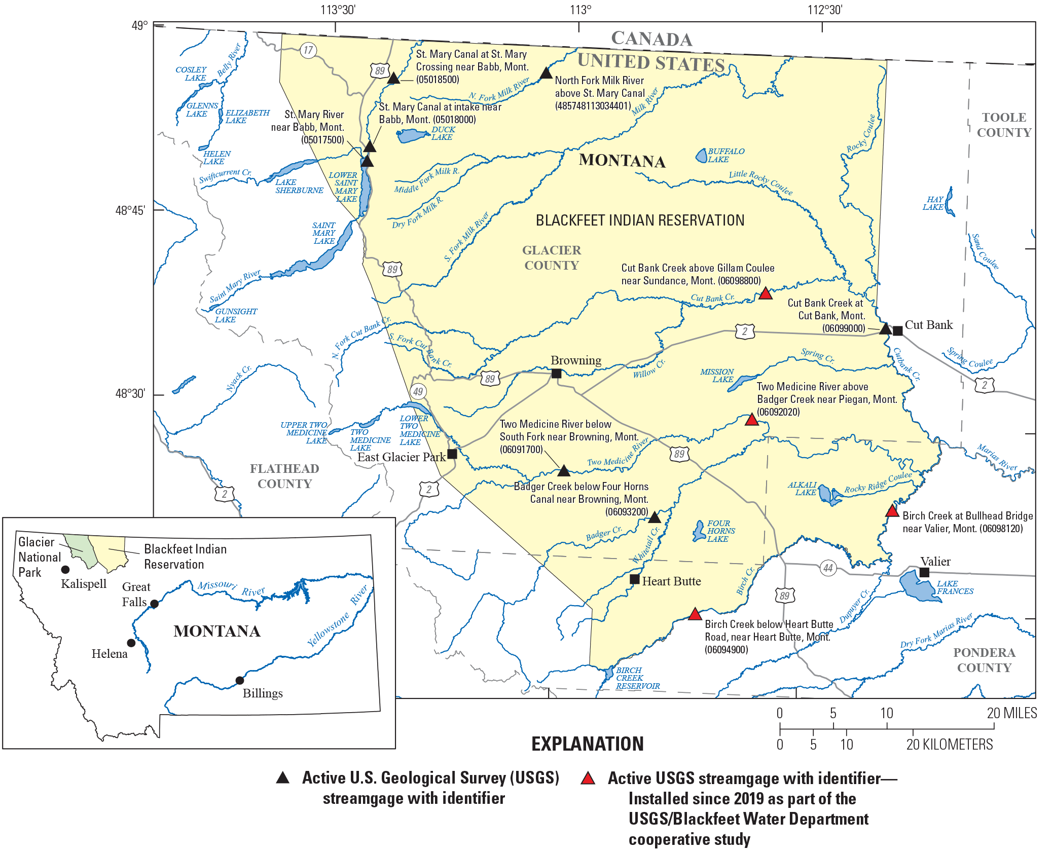
U.S. Geological Survey streamgages on the Blackfeet Indian Reservation of Montana.
Blackfeet Cooperative Hydrologic Assessment—Timeline and Goals
Phase 1 (2019):
-
• Compiled existing hydrologic data and identified locations to begin additional data collection.
-
• Installed two USGS streamgages (fig. 2A–B): (1) Cutbank Creek above Gillam Coulee, near Sundance, Montana (USGS station number 06098800), and (2) Two Medicine River above Badger Creek, near Piegan, Mont. (USGS station number 06092020). Data for both streamgages are available online in 15-minute intervals (U.S. Geological Survey, 2022).
-
• Established a project web page that includes a project description and links for data display and retrieval (https://www.usgs.gov/centers/wyoming-montana-water-science-center/science/hydrologic-assessment-blackfeet-reservation).
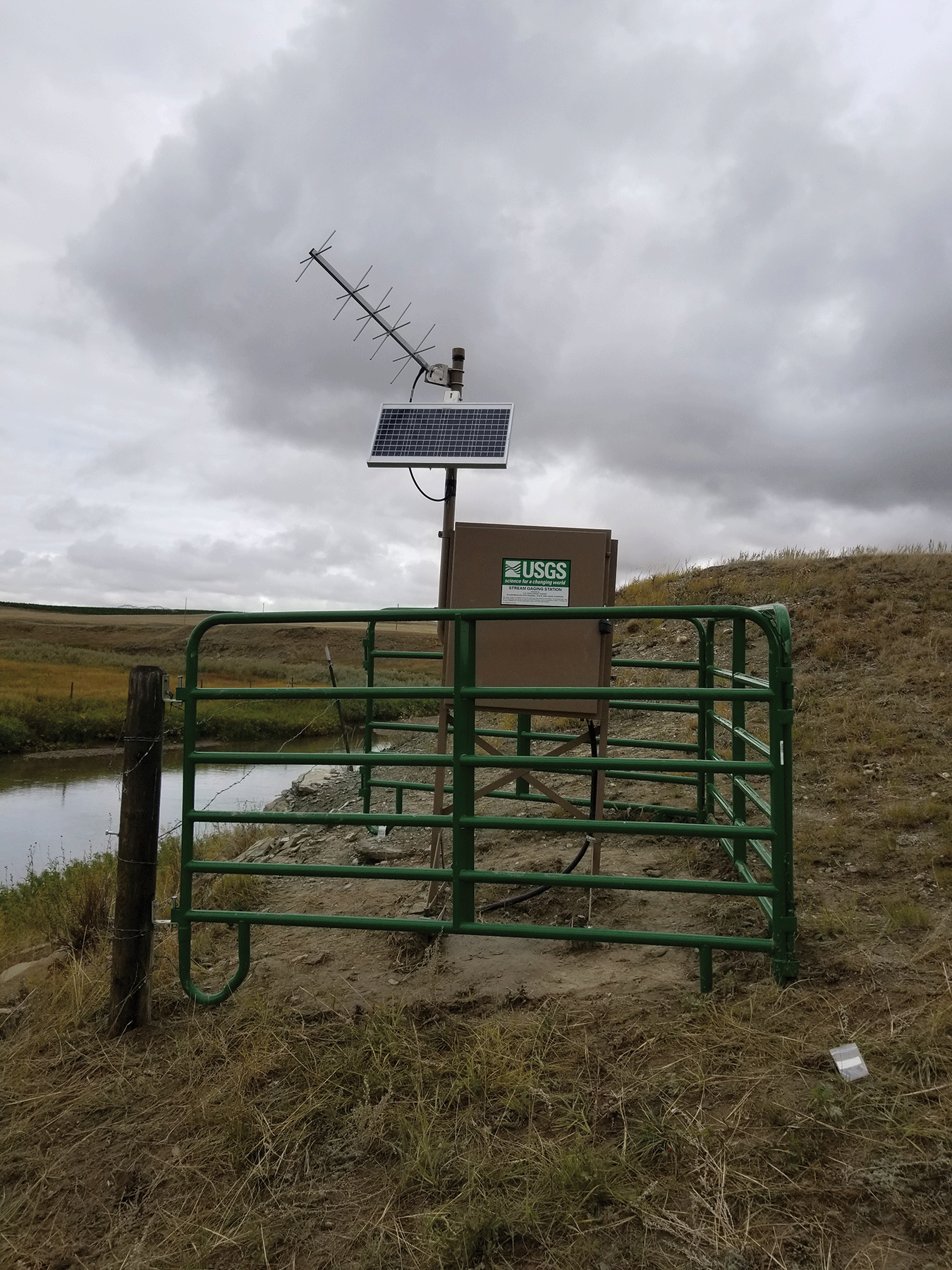

U.S. Geological Survey streamgages installed September 19, 2019. A, Cut Bank Creek above Gillam Coulee, near Sundance, Montana (06098800). B, Two Medicine River above Badger Creek, near Piegan, Montana (06092020).
Phase 2 (2020):
Installation of U.S. Geological Survey streamgage at Birch Creek at Bullhead Bridge near Valier, Montana (06098120), on August 25, 2020.
Phase 3 (2021 and ongoing):
-
• Continued operation of streamgages installed during phases 1 and 2 and identified locations for additional streamgages.
-
• Installed a fourth USGS streamgage on Birch Creek below Heart Butte Road, near Heart Butte, Mont. (USGS station number 06094900) (fig. 5).
-
• The Blackfeet Hydrologic Assessment Technical Working Group was established in the spring of 2022. The working group is moderated by the BWD as a venue to discuss ongoing project design and implementation.
-
• Discrete synoptic discharge measurements and the associated data management was completed for the Birch Creek drainage during 2022. The synoptic measurements are aimed at understanding the gains and losses in streamflow on the main stem, including contributions from tributaries and withdrawals for irrigation. The synoptic measurements included field demonstrations for BWD staff and member of the Blackfeet Tribe.
-
• The Montana Bureau of Mines and Geology installed two groundwater wells in 2022 using funding provided by the USGS National Ground-Water Monitoring Network Program (https://cida.usgs.gov/ngwmn/?msclkid=5bb4833bc80511ecb5404eed53d67db5). This well will be maintained and monitored by the USGS as part of the Blackfeet Hydrology Project and the USGS Climate Response Network (https://waterdata.usgs.gov/networks/CRN/?msclkid=c293b955c80411ecbc84dfa5decc8993).
Data Access
Current and recent data collected for this project are available to the public through the USGS National Water Information System (U.S. Geological Survey, 2022). The data include river stage, discharge, and river temperature in 15-minute and daily average time steps (fig. 6).
Next Steps
The USGS is currently working with the BWD to complete phase 3 of the project. The newly formed Blackfeet Hydrologic Assessment Technical Working Group will recommend locations of additional surface-water and groundwater monitoring locations to benefit future water resources decisions for the Blackfeet Nation.
A network of streamgages and monitoring wells throughout the Blackfeet Indian Reservation will help establish a quantitative understanding of surface-water and groundwater resources throughout the reservation.
Future activities may include the following:
-
• Synoptic streamflow measurements of selected streams and canals in the area to examine gains and losses over various conditions.
-
• Evaluation of site locations for the installation of new streamgages.
-
• Review of existing reports, geologic maps, and drillers’ logs for future groundwater and water-quality assessments.
An additional project goal is to strengthen the technical knowledge and capabilities of Blackfeet Tribal members to collect, evaluate, and manage hydrologic data. The USGS will offer training opportunities for BWD personnel, faculty and students from the Blackfeet Community College, and others from the Blackfeet Tribal community during future phases of this project.

Gerald Lunak, Director, Blackfeet Water Department. “The partnership with USGS enhances the Blackfeet Tribe’s ability to manage the waters of the Blackfeet Nation.” —Gerald Lunak, Director, Blackfeet Water Department, Blackfeet Nation, Montana (September 26, 2019).

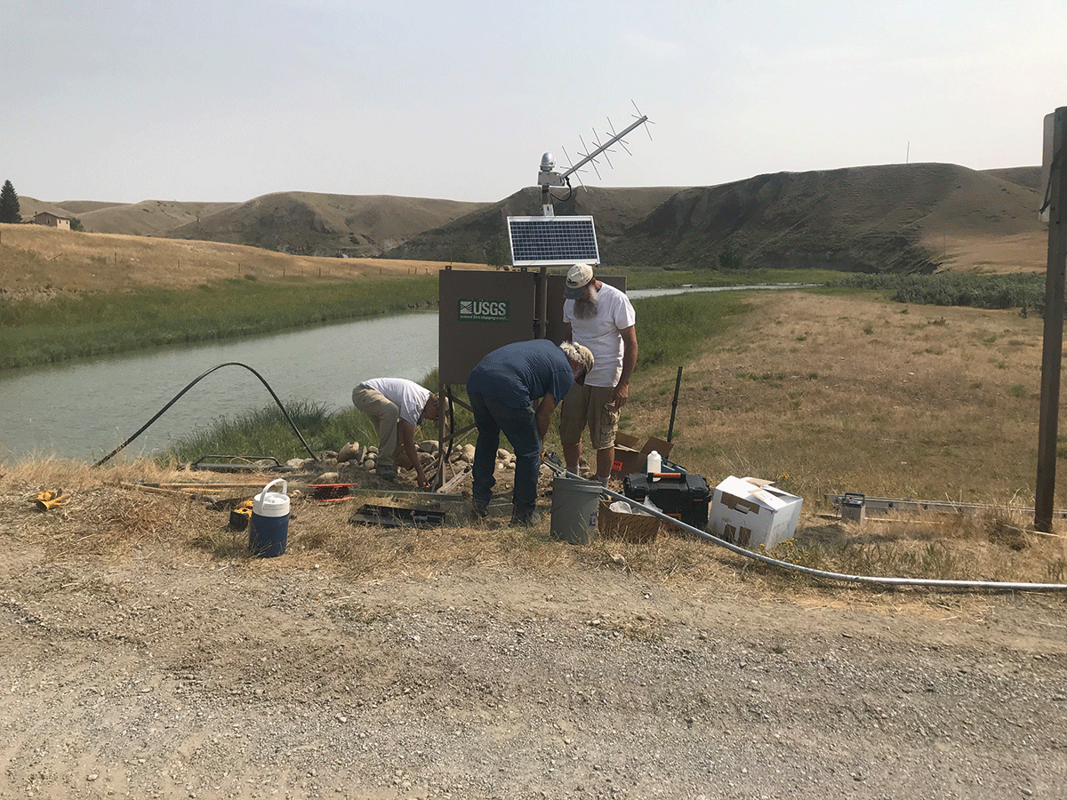
U.S. Geological Survey streamgage at Birch Creek below Heart Butte Road, near Heart Butte, Montana (06094900), on September 14, 2021.

Streamflow (discharge) during September 18, 2019, to October 6, 2021, at the U.S. Geological Survey Two Medicine River above Badger Creek near Piegan, Montana, streamgage (06092020) (U.S. Geological Survey, 2022).
Selected References
Adams, B., Barcus, C., Running Wolf, G., and Caldwell, R.R., 2017, Establishment of a baseline groundwater-quality monitoring program in an area of current and proposed energy development on the Blackfeet Reservation, Montana: American Water Resources Association, Montana section, 2017 Conference proceedings, October 18–20, 2017, 43 p. [Also available at https://www.montanaawra.org/wp-content/uploads/2017/10/2017-AWRA-Proceedings-1.pdf.]
Cannon, M.R., 1996, Geology and ground-water resources of the Blackfeet Indian Reservation, northwestern Montana: U.S. Geological Survey Hydrologic Investigations Atlas HA–737, 2 sheets. [Also available at https://doi.org/10.3133/ha737.]
Cannon, M.R., 1997, Water resources of the Browning-Starr school area, Blackfeet Indian Reservation, northwestern Montana: U.S. Geological Survey Water-Resources Investigations Report 97–4134, 39 p. [Also available at https://doi.org/10.3133/wri974134.]
Montana State Legislature, 2021, Water rights compact entered into by the Blackfeet Tribe of the Blackfeet Indian Reservation, the State Of Montana, and the United States ratified: Montana Code Annotated 2021, title 85, chap. 20, part 15, accessed October 13, 2022, at https://leg.mt.gov/bills/mca/title_0850/chapter_0200/part_0150/section_0010/0850-0200-0150-0010.html.
Turnipseed, D.P., and Sauer, V.B., 2010, Discharge measurements at gaging stations: U.S. Geological Survey Techniques and Methods, book 3, chap. A8, 87 p. [Also available at https://doi.org/10.3133/tm3A8.]
U.S. Geological Survey, 2022, USGS water data for the Nation: U.S. Geological Survey National Water Information System, accessed October 13, 2022, at https://doi.org/10.5066/F7P55KJN.
For more information about this publication, contact:
Director, USGS Wyoming-Montana Water Science Center
3162 Bozeman Avenue, Helena, MT 59601
406–457–5900
For additional information, visit: https://www.usgs.gov/centers/wyoming-montana-water-science-center
Publishing support provided by
the Rolla Publishing Service Center
Disclaimers
Any use of trade, firm, or product names is for descriptive purposes only and does not imply endorsement by the U.S. Government.
Although this information product, for the most part, is in the public domain, it also may contain copyrighted materials as noted in the text. Permission to reproduce copyrighted items must be secured from the copyright owner.
Suggested Citation
Lawlor, S.M., Caldwell, R.R., Bartos, T.T., and Price, B., 2023, U.S. Geological Survey and Blackfeet Water Department Hydrologic Assessment of the Blackfeet Indian Reservation, Montana: U.S. Geological Survey Fact Sheet 2023–3012, 4 p., https://doi.org/10.3133/fs20233012.
ISSN: 2327-6932 (online)
Study Area
| Publication type | Report |
|---|---|
| Publication Subtype | USGS Numbered Series |
| Title | U.S. Geological Survey and Blackfeet Water Department Hydrologic Assessment of the Blackfeet Indian Reservation, Montana |
| Series title | Fact Sheet |
| Series number | 2023-3012 |
| DOI | 10.3133/fs20233012 |
| Publication Date | April 03, 2023 |
| Year Published | 2023 |
| Language | English |
| Publisher | U.S. Geological Survey |
| Publisher location | Reston, VA |
| Contributing office(s) | Wyoming-Montana Water Science Center |
| Description | Report: 4 p.; Dataset |
| Country | United States |
| State | Montana |
| Other Geospatial | Blackfeet Indian Reservation |
| Online Only (Y/N) | Y |