

Assessment of Continuous Oil and Gas Resources in the Bakken Formation of Northwest Montana, 2022
Links
- Document: Report (892 kB pdf) , HTML , XML
- Data Release: USGS data release - USGS National and Global Oil and Gas Assessment Project—Northwest Montana Bakken Formation: Assessment Unit Boundaries, Assessment Input Data, and Fact Sheet Data Tables
- NGMDB Index Page: National Geologic Map Database Index Page (html)
- Download citation as: RIS | Dublin Core
Abstract
Using a geology-based assessment methodology, the U.S. Geological Survey estimated means of 220 million barrels of continuous oil and 1 trillion cubic feet of continuous gas in the Bakken Formation of northwest Montana.
Introduction
The U.S. Geological Survey (USGS) assessed the potential for undiscovered, technically recoverable continuous oil and gas resources in the Bakken Formation of northwest Montana (fig. 1). In the Late Devonian and Early Mississippian, contractional deformation of crust associated with east-dipping subduction (Antler orogeny) formed a north–south trending foredeep, slope, and platform collectively called the Antler foreland in the United States and the Prophet trough in Canada (Fuentes and others, 2012; Beranek and others, 2016). An extensive west-dipping carbonate ramp formed along the eastern part of the foreland platform, and organic-rich transgressive mudstones of the Bakken Formation and Exshaw Formation were deposited to the west along the slope and foredeep (Smith and Bustin, 2000). Renewed subduction along the western cratonic margin of North America during the Jurassic led to the progressive eastward-directed thrusts of the Sevier fold and thrust belt which persisted through the Paleogene. The progressive imbrication of eastward-directed thrust sheets of the Montana thrust belt, including the emplacement of the several-kilometer-thick Lewis thrust sheet during the Laramide orogeny, resulted in burial and levels of thermal maturity adequate to generate oil and gas from organic-rich mudstones of the Bakken Formation in the United States and Exshaw Formation in Canada (Clayton and others, 1982; Dolson and others, 1993).
Total Petroleum System and Assessment Units
The USGS defined the Bakken Formation Total Petroleum System (TPS) which includes the NW Montana Bakken Formation Continuous Oil Assessment Unit (AU) and the NW Montana Bakken Formation Continuous Gas AU (fig. 1). Both AUs are bounded to the north by the international border with Canada and to the south by the Scapegoat-Ballantyne structural trend (Dolson and others, 1993). The Bakken Continuous Oil AU is bounded to the east by the 0.5 percent vitrinite reflectance contour and to the west by the 1.3 percent vitrinite reflectance contour (Dolson and others, 1993). The adjacent Bakken Continuous Gas AU is bounded to the east by the 1.3 percent vitrinite reflectance contour, and to the west by the footwall of the frontal thrust of the Montana Thrust Belt. South of the Scapegoat-Ballantyne structural trend, the term Sappington Formation is used in place of Bakken Formation (Pasquo and others, 2019; Browne and others, 2020; Schultz and Hofmann, 2021). The stratigraphy and lithology of the Bakken Formation in northwest Montana is like the Bakken Formation in the Williston Basin and the Exshaw Formation in Alberta, Canada (Smith and Bustin, 2000), with an informal lower organic-rich black shale unit, a middle siliciclastic unit, and an upper organic-rich black shale unit (Smith and Bustin, 2000). The lower black shale unit has total organic carbon (TOC) values as high as 20 weight percent, hydrogen index (HI) values up to 906 milligrams hydrocarbon per gram of TOC (mg HC/g TOC), and a maximum thickness of 20 meters (m; Smith and others, 1995; Smith and Bustin, 2000). The middle siliciclastic unit is up to 13 m thick (Smith and others, 1995). The upper black shale unit has TOC values up to 14 weight percent, HI values as high as 1,060 mg HC/g TOC and is up to 7 m thick (Smith and others, 1995; Smith and Bustin, 2000). Mudstones of the Bakken Formation in northwest Montana achieved adequate thermal maturity for oil and gas generation during Laramide thrust loading and burial (Clayton and others, 1982; Dolson and others, 1993). Upon generation, oil and gas migrated into conventional fractured carbonate and karst reservoirs of the Mississippian Madison Group and other Paleozoic carbonates, and Mesozoic clastic reservoirs within structural and stratigraphic traps, as shown by the oil and gas accumulations of Cutbank Field and other fields (Dolson and others, 1993). The geologic model for this assessment of continuous oil and gas resources is for some portion of the oil and gas to have been retained within the Bakken Formation as a continuous resource following migration. Shows of oil during production tests in the Bakken Formation indicate that movable oil does exist within part of the Bakken Continuous Oil AU (Just and others, 2014). However, with proximity to the thrust belt, fracturing may become more pervasive to the west and may have caused increased migration or loss of oil and gas in the absence of an adequate top seal. The assessment input data for two continuous AUs are summarized in table 1 and in Schenk (2023).
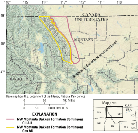
Map showing location of two continuous oil and gas assessment units (AUs) in the Bakken Formation of northwest Montana.
Table 1.
Key input data for two continuous oil and gas assessment units in the Bakken Formation of northwest Montana.[AU, assessment unit; NW, northwest; %, percent; EUR, estimated ultimate recovery; MMBO, million barrels of oil. The average EUR input is the minimum, median, maximum, and calculated mean. Gray shading indicates not applicable]
Undiscovered Resources Summary
The USGS quantitatively assessed undiscovered oil and gas resources within two continuous assessment units in the Bakken Formation of northwest Montana (table 2). The estimated mean totals for continuous resources are 220 million barrels of oil (MMBO), or 0.2 billion barrels of oil, with an F95–F5 range from 62 to 431 MMBO; 1,030 billion cubic feet of gas (BCFG), or 1 trillion cubic feet of gas, with an F95–F5 range from 274 to 2,056 BCFG; and 24 million barrels of natural gas liquids (MMBNGL), or 0.02 billion barrels, with an F95–F5 range from 7 to 48 MMBNGL.
Table 2.
Results for two continuous assessment units in the Bakken Formation of northwest Montana.[AU, Assessment units; MMBO, million barrels of oil; BCFG, billion cubic feet of gas; NGL, natural gas liquids; MMBNGL, million barrels of natural gas liquids; NW, northwest. Results shown are fully risked estimates. F95 represents a 95-percent chance of at least the amount tabulated; other fractiles are defined similarly. Gray shading indicates not applicable]
For More Information
Assessment results are also available at the USGS Energy website, https://www.usgs.gov/energy-and-minerals/energy-resources-program/.
Northwest Montana Bakken Assessment Team
Christopher J. Schenk, Michael H. Gardner, Tracey J. Mercier, Cheryl A. Woodall, Phuong A. Le, Andrea D. Cicero, Ronald M. Drake II, Geoffrey S. Ellis, Thomas M. Finn, Sarah E. Gelman, Jane S. Hearon, Benjamin G. Johnson, Jenny H. Lagesse, Heidi M. Leathers-Miller, Kristen R. Marra, Kira K. Timm, and Scott S. Young.
References Cited
Beranek, L.P., Link, P.K., and Fanning, C.M., 2016, Detrital zircon record of mid-Paleozoic convergent margin activity in the northern U.S. Rocky Mountains—Implications for the Antler orogeny and early evolution of the North American Cordillera: Lithosphere, v. 8, no. 5, p. 533–550, accessed August 24, 2022, at https://doi.org/10.1130/L557.1.
Browne, T.N., Hofmann, M.H., Malkowski, M.A., and Wei, J., 2020, Redox and paleoenvironmental conditions of the Devonian–Carboniferous Sappington Formation, southwestern Montana, and comparison to the Bakken Formation, Williston Basin: Paleogeography, Paleoclimatology, Paleoecology, v. 560, 16 p., accessed August 17, 2021, at https://doi.org/10.1016/j.palaeo.2020.110025.
Fuentes, F., DeCelles, P.G., and Constenius, K.N., 2012, Regional structure and kinematic history of the Cordilleran fold-thrust belt in northwestern Montana, USA: Geosphere, v. 8, no. 5, p. 1104–1128, accessed August 24, 2022, at https://doi.org/10.1130/GES00773.1.
Just, B., Lloyd, R., and Mohseni, P., 2014, Oil and gas development opportunities on the Blackfeet Indian Reservation, Montana: Blackfeet Nation, Division of Energy and Mineral Development, 9 p., accessed August 24, 2022, at https://www.bia.gov/sites/default/files/dup/assets/as-ia/ieed/pdf/idc1-026003_508.pdf.
Pasquo, M. di, Grader, G.W., Kondas, M., Doughty, P.T., Filipiak, P., Rice, B.J., and Isaacson, P.E., 2019, Lower Sappington Formation palynofacies in Montana confirm upper Famennian black shale paleoenvironments and sequences across western North America: Paleogeography, Paleoclimatology, Paleoecology, v. 536, 19 p., accessed August 17, 2021, at https://doi.org/10.1016/j.palaeo.2019.109370.
Schenk, C.J., 2023, USGS National and Global Oil and Gas Assessment Project–Northwest Montana Bakken Formation, assessment unit boundaries, assessment input data, and fact sheet data tables: U.S. Geological Survey data release, https://doi.org/10.5066/P9U35UM2.
Schultz, C.D., and Hofmann, M.H., 2021, Facies, stratigraphic architecture, and faults—The controls on the cement distribution in the Devonian Sappington Formation in southwestern Montana: Marine and Petroleum Geology, v. 124, 23 p., accessed August 17, 2021, at https://doi.org/10.1016/j.marpetgeo.2020.104806.
Smith, M.G., and Bustin, R.M., 2000, Late Devonian and Early Mississippian Bakken and Exshaw black shale source rocks, Western Canada Sedimentary Basin—A sequence stratigraphic interpretation: American Association of Petroleum Geologists Bulletin, v. 84, no. 7, p. 940–960, accessed August 24, 2022, at https://doi.org/10.1306/A9673B76-1738-11D7-8645000102C1865D.
Smith, M.G., Bustin, R.M., and Caplan, M.L., 1995, Sequence stratigraphy of the Bakken and Exshaw Formations—A continuum of black shale formations in the Western Canada Sedimentary Basin, in Hunter, L.D.V., and Schalla, R.A., eds., Seventh International Williston Basin Symposium, July 23, 1995: Montana Geological Society Special Publication, p. 399–409, accessed August 24, 2022, at https://archives.datapages.com/data/mgs_wb_utf/data/0008/0000/0000.html.
Disclaimers
Any use of trade, firm, or product names is for descriptive purposes only and does not imply endorsement by the U.S. Government.
Although this information product, for the most part, is in the public domain, it also may contain copyrighted materials as noted in the text. Permission to reproduce copyrighted items must be secured from the copyright owner.
Suggested Citation
Schenk, C.J., Gardner, M.H., Mercier, T.J., Woodall, C.A., Le, P.A., Cicero, A.D., Drake, R.M., II, Ellis, G.S., Finn, T.M., Gelman, S.E., Hearon, J.S., Johnson, B.G., Lagesse, J.H., Leathers-Miller, H.M., Marra, K.R., Timm, K.K., Young, S.S., 2023, Assessment of continuous oil and gas resources in the Bakken Formation of northwest Montana, 2022: U.S. Geological Survey Fact Sheet 2023–3016, 2 p., https://doi.org/10.3133/fs20233016.
ISSN: 2327-6932 (online)
Study Area
| Publication type | Report |
|---|---|
| Publication Subtype | USGS Numbered Series |
| Title | Assessment of continuous oil and gas resources in the Bakken Formation of northwest Montana, 2022 |
| Series title | Fact Sheet |
| Series number | 2023-3016 |
| DOI | 10.3133/fs20233016 |
| Publication Date | June 07, 2023 |
| Year Published | 2023 |
| Language | English |
| Publisher | U.S. Geological Survey |
| Publisher location | Reston VA |
| Contributing office(s) | Central Energy Resources Science Center |
| Description | Report: 2 p.; Data Release |
| Country | United States |
| State | Montana |
| Other Geospatial | Bakken Formation |
| Online Only (Y/N) | Y |