

The 3D Elevation Program—Supporting Oregon’s Economy
Links
- Document: Report (1.61 MB pdf) , HTML , XML
- Download citation as: RIS | Dublin Core
Introduction
Oregon’s physical environments and vegetation are diverse. The State has wet coastal and dry interior mountain ranges, divided by the volcanic peaks of the Cascade Range; a long coastline; interior valleys and basins; and high desert and semi-arid steppe. The varied geologic and climatic conditions combined with increasing population have created the need for high-quality elevation data that can be used for infrastructure management, forestry and wildfire management, agriculture, natural resources conservation, and other business uses. Critical applications that meet the State’s management needs depend on light detection and ranging (lidar) data that provide a highly detailed three-dimensional (3D) model of the Earth’s surface and aboveground features.
The 3D Elevation Program (3DEP; see sidebar) is managed by the U.S. Geological Survey (USGS) in partnership with Federal, State, Tribal, U.S. territorial, and local agencies to acquire consistent lidar coverage at quality level 2 or better (table 1) to meet the many needs of the Nation and Oregon. The status of available and in-progress 3DEP baseline lidar data in Oregon is shown in figure 1. 3DEP baseline lidar data include quality level 2 or better, 1-meter or better digital elevation models, and lidar point clouds, and must meet the Lidar Base Specification version 1.2 (https://www.usgs.gov/3dep/lidarspec) or newer requirements. The National Enhanced Elevation Assessment (Dewberry, 2012) identified user requirements and conservatively estimated that availability of lidar data would result in at least $45.7 million in new benefits annually to the State. The top 10 Oregon business uses for 3D elevation data, which are based on the estimated annual conservative benefits of 3DEP, are shown in table 2.
Table 1.
Data quality levels, pulse spacing, and pulse density. Quality level 2 or better lidar data meet 3DEP requirements.[Specifications for quality level 0 (QL0) are from Heidemann (2014, p. 3 and table 1); for quality levels 1 and 2 the specifications are from Sugarbaker and others (2014, table 1). In the quality level column, QL0 represents the highest level of quality. RMSEz, root mean square error in the elevation (z) dimension; cm, centimeter; m, meter; pls/m2, first return pulses per square meter; ≤,less than or equal to; ≥,greater than or equal to]
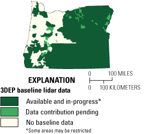
Map of Oregon showing status of 3D Elevation Program (3DEP) baseline lidar data as of May 2023. Visit https://usgs.gov/NationalMap/LidarExplorer to find and download currently available data.
Table 2.
Conservative benefits estimates for the top 10 Oregon business uses of the proposed 3DEP data identified in the National Enhanced Elevation Assessment (Dewberry, 2012).Infrastructure and Construction Management
The Oregon Department of Transportation (ODOT) has been using lidar for a variety of project purposes since 2005 (Luccio, 2015). ODOT has found lidar to be valuable in saving project time and in enhancing employee safety in rugged or remote areas. For example, after the Hooskanaden landslide disrupted U.S. Route 101 in southwestern Oregon in 2019 (fig. 2), ODOT used lidar for hydraulic engineering design, in analysis for dewatering the slide zone, and in determining earthwork for redesign of the highway.
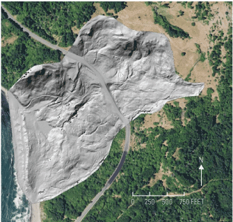
Aerial lidar image of the Hooskanaden landslide along U.S. Route 101 in southwestern Oregon, overlaid on an orthophotograph and used for siting a new road, which included earthwork and drainage engineering. Image courtesy of Oregon Department of Transportation.
Flood Risk Management
The Oregon Department of Geology and Mineral Industries uses lidar data to generate precise, accurate, and credible flood maps to help in assessing and mitigating flood risk throughout Oregon. As a result, the State can more accurately and rapidly determine flood risk to the population and implement remedial measures to improve the safety of dams and levees, thereby reducing the risk of loss of life as well as the expenses associated with property damage.
Wildfire Management, Planning, and Response
Oregon has experienced record-setting wildfires in the last several years and there is concern that the trend may continue; thus, the benefits of including lidar data in wildfire management, planning, and response may increase significantly. Firefighting costs in Oregon now exceed $500 million during high-fire seasons. As of November 2019, this was 11 times more than the cost of preventing wildfires (Governor’s Council on Wildfire Response, 2019). High-resolution 3D elevation data support fire behavior modeling, fire response, vegetation-load appraisal, and post-fire assessment for slope instability, leading to improved public safety.
Geologic Resource Assessment and Hazard Mitigation
Geologic mapping, including assessing mineral deposits and geologic hazards, can be performed more efficiently and accurately using lidar data. According to Ian Madin (Oregon Department of Geology and Mineral Industries), “Lidar has become an essential tool for geologic mapping in Oregon. From planning fieldwork to identifying surficial deposits and making base maps, lidar is used in every step of the process” (written commun., August 30, 2019).
“Lidar provides a powerful tool for understanding our world from a truly unique perspective. With its applicability to a wide variety of real-world issues, lidar is key to successful planning, management, conservation, and operations across all sectors. From alerting land-use planners to the potential for devastating landslides and tsunamis to enabling the highest resolutions for mapping of urban and rural infrastructure assets, to enabling highest accuracy modeling of many natural patterns and processes, lidar is living up to its promise to be a technology that will change the mapping landscape for generations. Having statewide access to lidar will provide Oregon with one of the most powerful and critical datasets available today.”
(Cy Smith, Oregon Geospatial Information Officer, August 30, 2019).
3D Elevation Program (3DEP)
The 3D Elevation Program is managed by the U.S. Geological Survey (USGS) on behalf of the community of Federal, State, Tribal, local, and other partners and users of elevation data. In response to growing needs for high-quality elevation data, the goal of 3DEP is to complete acquisition of nationwide light detection and ranging (lidar) data (interferometric synthetic aperture radar [IfSAR] data in Alaska) to provide the first-ever national baseline of consistent, high-resolution topographic elevation data—both bare-earth digital elevation models and 3D point clouds.
Benefits
-
• Economies of scale by acquiring data for larger areas.
-
• Predictable and flexible Federal investments that reduce costs and allow better planning.
-
• Consistent national coverage that provides data for applications that span project, jurisdictional, and watershed boundaries.
-
• Simplified data acquisition that provides contracts, project management, quality assurance, and published data specifications.
-
• National benefits of $690 million per year conservatively, with the potential to generate $13 billion per year in additional benefits through applications that span the economy (Dewberry, 2012).
High-Quality Data and Products
3DEP lidar data provide coverage with a minimum of two points per square meter and a vertical error not to exceed 10 centimeters, measured as root mean square error in the elevation (z) dimension (RMSEz) (see table 1). 3DEP baseline lidar data products include all data points collected (point clouds) and bare-earth digital elevation models with a 1-meter or better resolution. The USGS integrates the elevation data into The National Map. Data are available free of charge and without use restrictions. To download 3DEP products visit https://apps.nationalmap.gov/downloader/.
Ways to Participate
Participation in 3DEP is open to Federal, State, Tribal, U.S. territorial, and local government partners, as well as private sector partners, and offers the option to acquire higher quality data. Partners may contribute funds toward projects managed by the USGS, or they may receive cooperative funds to manage their own projects. An annual Broad Agency Announcement is the mechanism used to establish partner agreements. Organizations and the private sector may contribute existing data that meet 3DEP requirements. For more information refer to the 3DEP website at https://usgs.gov/3DEP/collaborate/.
References Cited
Dewberry, 2012, Final report of the National Enhanced Elevation Assessment (revised March 29, 2012): Fairfax, Va., Dewberry, 84 p. plus appendixes, accessed May 17, 2021, at https://www.dewberry.com/services/geospatial/national-enhanced-elevation-assessment.
Governor’s Council on Wildfire Response, 2019, November 2019—Report and recommendations: [Oregon] Governor’s Council on Wildfire Response, report, 109 p., accessed June 20, 2022, at https://www.oregon.gov/osfm/Documents/GovWildfireCouncilRpt-Final-Recs.pdf.
Heidemann, H.K, 2014, Lidar base specification (ver. 1.2, November 2014): U.S. Geological Survey Techniques and Methods, book 11, chap. B4, 67 p. with appendixes, accessed August 5, 2022, at https://doi.org/10.3133/tm11B4.
Luccio, M., 2015, The Oregon Lidar Consortium: xyHt Magazine, article dated January 8, 2015, accessed April 15, 2020, at https://www.xyht.com/professional-surveyor-archives/the-oregon-lidar-consortium/.
Sugarbaker, L.J., Constance, E.W., Heidemann, H.K., Jason, A.L., Lukas, V., Saghy, D.L., and Stoker, J.M., 2014, The 3D Elevation Program initiative—A call for action: U.S. Geological Survey Circular 1399, 35 p., accessed August 5, 2022, at https://doi.org/10.3133/cir1399.
For Further Information:
Director, National Geospatial Program
U.S. Geological Survey, MS 511
12201 Sunrise Valley Drive
Reston, VA 20192
Email: 3DEP@usgs.gov
USGS National Map Liaison:
Tom Carlson; Email: tcarlson@usgs.gov
Disclaimers
Any use of trade, firm, or product names is for descriptive purposes only and does not imply endorsement by the U.S. Government.
Although this information product, for the most part, is in the public domain, it also may contain copyrighted materials as noted in the text. Permission to reproduce copyrighted items must be secured from the copyright owner.
Suggested Citation
Carlson, T., 2023, The 3D Elevation Program—Supporting Oregon's economy: U.S. Geological Survey Fact Sheet 2023–3029, 2 p., https://doi.org/10.3133/fs20233029.
ISSN: 2327-6932 (online)
ISSN: 2327-6916 (print)
Study Area
| Publication type | Report |
|---|---|
| Publication Subtype | USGS Numbered Series |
| Title | The 3D Elevation Program—Supporting Oregon's economy |
| Series title | Fact Sheet |
| Series number | 2023-3029 |
| DOI | 10.3133/fs20233029 |
| Publication Date | August 15, 2023 |
| Year Published | 2023 |
| Language | English |
| Publisher | U.S. Geological Survey |
| Publisher location | Reston, VA |
| Contributing office(s) | National Geospatial Program |
| Description | 2 p. |
| Country | United States |
| State | Oregon |
| Online Only (Y/N) | N |
| Additional Online Files (Y/N) | N |