

Predicting Water Quality in the Clark Fork near Grant-Kohrs Ranch National Historic Site, Southwestern Montana
Links
- Document: Report (1 MB pdf) , HTML , XML
- Data Release: USGS data release - Water quality and streamflow data for the Clark Fork near Grant-Kohrs Ranch National Historic Site in southwestern Montana, water years 2019–2020
- NGMDB Index Page: National Geologic Map Database Index Page (html)
- Download citation as: RIS | Dublin Core
Grant-Kohrs Ranch National Historic Site
The establishment of Grant-Kohrs Ranch in the 1860s by stockgrower Johnny Grant and cattle baron Conrad Kohrs marked the beginning of 120 years of one of the largest open-range cattle operations in the Western United States (Grant-Kohrs Ranch, 2004). The ranch was designated a national historic landmark in 1960 and a unit of the National Park Service (NPS) by Congress in 1972. In 2023, the Grant-Kohrs Ranch National Historic Site (GRKO) encompassed 1,618 acres in southwestern Montana near the town of Deer Lodge (fig. 1). The ranch is unique because of its proximity to large-scale mining of gold, silver, copper, and lead ore from the 1860s to the 1980s in the Butte mining district. It has the distinction of being the only NPS unit to be included on the National Priority List for Superfund cleanup (U.S. Environmental Protection Agency, 2004). GRKO provides an authentic historic setting to about 15,000–20,000 visitors annually to experience the cattle industry as it contributed to Western culture (Grant-Kohrs Ranch, 2004). The historic period of the ranch is conveyed by its original structures, family furnishings, ranching equipment, and its continued use of land and heritage skill for livestock production (Grant-Kohrs Ranch, 2004).
From 1864 to the 1980s, the Butte mining district—formerly known as the “Richest Hill on Earth”—brought immense economic wealth to the region (U.S. Environmental Protection Agency, 2004). During this period, mining and milling wastes were discarded in the upper Clark Fork Basin, resulting in the deposition of large amounts of waste materials enriched with metallic contaminants (including cadmium, copper, iron, lead, manganese, zinc, and the metalloid trace element arsenic) in soils and in nearby streams and floodplains of the Deer Lodge Valley (Gammons and others, 2006). Exposed mining waste (tailings), referred to as “slickens,” (fig. 2; patches of acidic soil resulting from high amounts of metals), appeared on the landscape and produced a toxic condition, causing damage to terrestrial and aquatic habitat in the Deer Lodge Valley that includes GRKO (U.S. Environmental Protection Agency, 2004). Denuded vegetation and fish kills attributed to large concentrations of heavy metals derived from the tailings caused the U.S. Environmental Protection Agency (EPA) to designate a 120-mile section of the Clark Fork River (fig. 1), hereafter referred to as the “Clark Fork,” including GRKO, as a Superfund site in 1989 (U.S. Environmental Protection Agency, 2004).
Real-Time Continuous Water-Quality Benefits—Montana
The USGS provides a wide range of streamflow, groundwater, and water-quality data to Government, commercial, academic, and public users. The USGS has a record of success with using optical turbidity sensors to predict suspended-sediment concentrations in rivers and streams. Turbidity sensors collect backscatter signals from suspended particles in water, which can be accurately measured and linked closely to hazardous contaminants that travel on the surfaces of suspended particles. Contaminant concentrations derived from the statistical relations between turbidity and contaminants like copper and lead can then be measured in real-time. Users can access real-time concentrations through the USGS web page available to the public (U.S. Geological Survey, 2023).
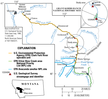
Location of the study area, Grant-Kohrs Ranch National Historic Site, U.S. Geological Survey streamgages, and National Priority List Superfund operable units in the upper Clark Fork Basin, Montana.
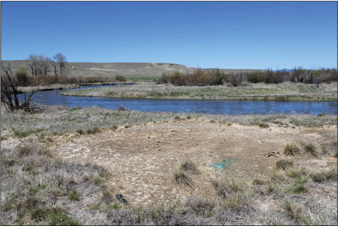
Before remediation of contaminated soils at Work Area G at the Clark Fork at Grant-Kohrs Ranch National Historic Site, Montana, May 2017.
In 2018, with oversight from the EPA and the Montana Department of Environmental Quality (MDEQ), the NPS began cleanup of 2.6 miles of the Clark Fork as it flows through GRKO property in an area with extensive floodplain and streambank deposits of contaminated mining wastes. Superfund cleanup in GRKO began in November 2018 with the planned excavation and removal of 400,000 cubic yards of contaminated soils within the park boundaries to be followed by landscaping, topsoil additions, and re-vegetation of the excavated soils (Research Specialist, Inc., 2020). Removal of contaminated soils was completed in November 2020 with the removal of 320,000 cubic yards of soil. Re-vegetation in contaminated areas was completed in concert with clean soil replacements. An example of contaminated soils at GRKO before and after cleanup in the Clark Fork floodplain is shown in figure 3.
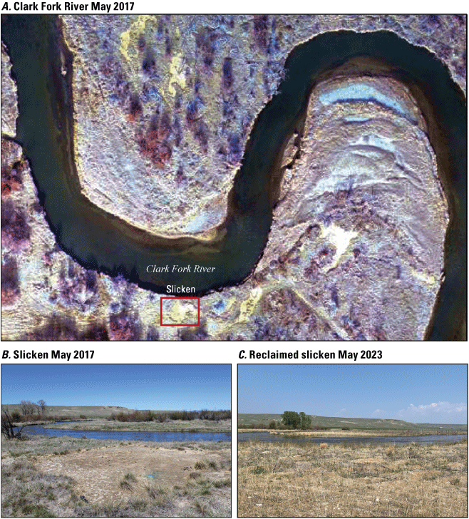
Remediation of contaminated soils at Work Area G at the Clark Fork at Grant-Kohrs Ranch National Historic Site, Montana. A, Aerial photo (May 2017) of the Clark Fork River at Work Area G. B, Before remediation (May 2017). C, After remediation (May 2023) (Photographs A and B courtesy of Jeff Johnson, National Park Service, Grant-Kohrs Ranch National Historic Site. Photograph C courtesy of U.S. Geological Survey).
Water-Quality Monitoring using Surrogate Technology
Water-quality standards provide the regulatory foundation to protect and restore water quality in Montana. The MDEQ is responsible for establishing aquatic-life standards in rivers and streams to protect fish and other aquatic life. Standards are designed to protect aquatic life by accounting for the concentration (for example, parts per billion [micrograms] of the pollutant in a liter of water, which varies by pollutant), duration of exposure to a pollutant (for example, an hour, day, month, year, and so forth), as well as the allowable frequency of exposure (for example, how often the standard is exceeded). Aquatic-life standards are separated into acute and chronic numeric standards. Acute aquatic-life standards are based on a 1-hour exposure event and can only be exceeded once, on average, in a 3-year period, whereas chronic aquatic-life standards are based on a 96-hour exposure event and can only be exceeded once, on average, in a 3-year period. These standards form the basis from which the MDEQ might designate a section of a river as being impaired and in need of rehabilitation.
The U.S. Geological Survey (USGS) monitors, conducts research, and provides information on a wide range of water resources including streamflow, groundwater, water quality, and water use and availability. Water-quality data, including streamflow data, are available online to the public in the USGS National Water Information System at https://doi.org/10.5066/F7P55KJN (U.S. Geological Survey, 2023). Water-quality data collection by the USGS, in cooperation with the EPA and MDEQ, began during 1985–88 in the upper Clark Fork Basin with the establishment of a small long-term monitoring network (LTMN) that continues to the present (2023; Sando and others, 2014). As part of the LTMN, the USGS collects water-quality samples eight times per year at two USGS streamgages just upstream and downstream from GRKO boundaries (fig. 1; Clark Fork at Deer Lodge, Mont. [streamgage 12324200; hereafter referred to as “Clark Fork at Deer Lodge”] and Clark Fork above Little Blackfoot River near Garrison, Mont. [streamgage 12324400; hereafter referred to as “Clark Fork near Garrison”] to monitor streamflow, metallic contaminants, nutrients, and suspended sediment (Clark and others, 2022).
USGS and NPS Collaborative Study
In 2019, the USGS, in cooperation with the NPS, conducted a 2-year study to provide an accurate, high-resolution monitoring tool for the GRKO to estimate metallic-contaminant concentrations (MCCs) in the Clark Fork during Superfund cleanup activities (Ellison and others, 2023). Although the LTMN provides water-quality and streamflow data to evaluate large-scale effects of cleanup activities in the upper Clark Fork Basin, the LTMN only collects eight samples per year between Clark Fork at Deer Lodge and Clark Fork near Garrison, which is not frequent enough to understand how NPS cleanup activities affect water quality as the Clark Fork flows through GRKO property. To overcome limitations inherent with periodically collected samples of the LTMN, turbidity surrogate data were collected, and statistical relations were developed between turbidity surrogate measurements and periodically collected MCCs of the LTMN and used to produce estimates of MCCs at a high-resolution time scale. The USGS has increasingly used measurements of turbidity, which is a measurement of water clarity, or transparency, to predict the concentration of suspended particles such as sediment, algae, and plankton, which cause water to appear cloudy or murky (Rasmussen and others, 2009). A higher turbidity reading represents cloudier water with more particles in suspension; conversely, when water is clear, turbidity levels are lower. There is a proven record of success for using backscatter signals from turbidity sensors to predict suspended-sediment concentrations (Rasmussen and others, 2009; Groten and others, 2016). Suspended-sediment concentration data can be used to describe the transport of metallic contaminants in the Clark Fork and provided the principal framework for the current study (Ellison and others, 2023). Suspended sediment is defined as fine (smaller than 0.063 millimeter in diameter) inorganic particles of clay and silt that are suspended in the water column. Suspended sediment also may include fine sand and particulate organic matter like algae and plankton. The link between suspended sediment and MCCs is based on the physical properties of fine-sized inorganic suspended sediment. The physical characteristics of suspended sediment, such as particle size, surface area, and surface electrical charge enable a sediment particle to collect and concentrate metallic contaminants (Horowitz, 1985).
Turbidity sensors were installed at USGS streamgages (Clark Fork at Deer Lodge and Clark Fork near Garrison) for monitoring suspended sediment during NPS cleanup of the Clark Fork streambanks and floodplains. The existing data collection from the LTMN was augmented with four additional sampling events each year in 2019 and 2020. Data from the turbidity sensors were recorded at 15-minute intervals and transmitted by satellite hourly to the USGS office in Helena, Mont. The close association between backscatter signals from turbidity sensors with suspended-sediment concentrations in the Clark Fork were expanded to use turbidity as a surrogate for predicting MCCs of cadmium, copper, iron, lead, manganese, zinc, and the metalloid trace element arsenic. Continuous real-time estimates of MCCs showing spikes and drops in MCCs, measured at a high-resolution time scale, may be linked with cleanup actions such as excavation of contaminated soils, streambank restoration activities, and re-vegetation of riparian and denuded regions of GRKO property.
Results of the Study
The application of high-resolution surrogate data from turbidity sensors provided insight on MCC transport and magnitude, and the data were used to infer contaminant sources and fate. For example, during initial snowmelt runoff in 2019 and 2020, copper concentrations peaked when streamflows were lower and prior to peak streamflow at Clark Fork at Deer Lodge and Clark Fork near Garrison. Because copper concentrations peaked prior to streamflow peaks, the source of copper may have ben channel bed sediments close to the monitoring site and (or) from nearby streambanks and floodplains, rather than sources higher in the drainage basin. High-resolution surrogate data revealed that copper concentrations at the Clark Fork at Deer Lodge exceeded chronic aquatic-life standards 90 percent of the time for streamflows that exceeded 200 cubic feet per second (ft3/s) and exceeded acute aquatic-life standards 85 percent of the time when streamflow exceeded 260 ft3/s. For Clark Fork near Garrison, copper concentrations exceeded chronic aquatic-life standards 85 percent of the time when streamflow exceeded 250 ft3/s and exceeded acute aquatic-life standards 50 percent of the time when streamflow exceeded 280 ft3/s (Ellison and others, 2023).
Water quality in the Clark Fork may improve following planned cleanup of contaminated soils in the floodplains in the Deer Lodge Valley above Clark Fork at Deer Lodge, which is currently underway by MDEQ (Research Specialist, Inc., 2020), and on GRKO property. Cleanup of the Clark Fork floodplains and streambanks downstream between GRKO property and Clark Fork near Garrison is in the planning stage and is key to measurable improvements in water quality in the Clark Fork. Ultimately, it is hoped that strides to improve water quality in the Clark Fork will enable MDEQ to remove the Clark Fork from the EPA’s 303(d) impaired waters list (Montana Department of Environmental Quality, 2021).
Data collected during the study are available in a USGS data release (Ellison, 2023).
References Cited
Clark, G.D., Hornberger, M.I., Hepler, E.J., and Heinert, T.L., 2022, Water-quality, bed-sediment, and invertebrate tissue trace-element concentrations for tributaries in the Clark Fork Basin, Montana, October 2019–September 2020: U.S. Geological Survey Open-File Report 2020–1067, 16 p., accessed June 2022 at https://doi.org/10.3133/ofr20221090.
Ellison, C.A., Sando, S.K., and Cleasby, T.E., 2023, Application of surrogate technology to predict real-time metallic-contaminant concentrations and loads in the Clark Fork near Grant-Kohrs Ranch National Historic Site, Montana, water years 2019–20. U.S. Geological Survey Scientific Investigations Report 2023–5021, 70 p., accessed June 2023 at https://doi.org/10.3133/sir20235021.
Ellison, C.A., 2023, Water quality and streamflow data for the Clark Fork near Grant-Kohrs Ranch National Historic Site in southwestern Montana, water years 2019–20: U.S. Geological Survey data release, accessed June 2023 at https://doi.org/10.5066/P9330BXM.
Gammons, C.H., Metesh, J.J., and Duaime, T.E., 2006, An overview of the mining history and geology of Butte, Montana: Mine Water and the Environment, v. 25, no. 2, p. 70–75, accessed November 2021 at https://doi.org/10.1007/s10230-006-0113-7.
Grant-Kohrs Ranch, 2004, Cultural landscape report, Part 1. Landscape history, existing conditions, and analysis and evaluation: National Park Service, 493 p., accessed November 2021 at https://www.nps.gov/parkhistory/online_books/grko/grko_clr_1.pdf.
Groten, J.T., Ellison, C.A., and Hendrickson, J.S., 2016, Suspended-sediment concentrations, bedload, particle sizes, surrogate measurements, and annual sediment loads for selected sites in the lower Minnesota River Basin, water years 2011 through 2016: U.S. Geological Survey Scientific Investigations Report 2016–5174, 29 p., accessed September 2021 at https://doi.org/10.3133/sir20165174.
Horowitz, A.J., 1985, A primer on trace metal-sediment chemistry: U.S. Geological Survey Water-Supply Paper 2277, 67 p., accessed November 2021 at https://doi.org/10.3133/wsp2277.]
Montana Department of Environmental Quality, 2021, Montana 2020 final water quality integrated report: Helena, Montana, Water Quality Planning Bureau, Water Quality Division, 86 p., accessed May 2022 at https://deq.mt.gov/files/Water/WQPB/CWAIC/Reports/IRs/2020/MT_2020_IR_Final.pdf.
Rasmussen, P.P., Gray, J.R., Glysson, G.D., and Ziegler, A.C., 2009, Guidelines and procedures for computing time-series suspended-sediment concentrations and loads from in-stream turbidity-sensor and streamflow data: U.S. Geological Survey Techniques and Methods, book 3, chap. C4, 52 p. [Also available at https://doi.org/10.3133/tm3C4.]
Research Specialist, Inc., 2020, Monitoring Report for 2019 Clark Fork River Operable Unit, Research Specialist, Inc., 815 East Front Street, Suite 3, Missoula, MT 59802, 276 p., accessed September 2021 at https://deq.mt.gov/cleanupandrec/Programs/superfundfed.
Sando, S.K., Vecchia, A.V., Lorenz, D.L., and Barnhart, E.P., 2014, Water-quality trends for selected sampling sites in the Upper Clark Fork Basin, Montana, water years 1996–2010: U.S. Geological Survey Scientific Investigations Report 2013–5217, 162 p., with appendixes. [Also available at https://doi.org/10.3133/sir20135217.]
U.S. Environmental Protection Agency, 2004, Record of decision, Clark Fork River Operable Unit of the Milltown Reservoir/Clark Fork River Superfund Site: Helena, Montana, U.S. Environmental Protection Agency, Region 8, accessed June 2021 at http://www2.epa.gov/sites/production/files/documents/Pt2DecisionSummary.pdf.
U.S. Geological Survey, 2023, USGS water data for the Nation: U.S. Geological Survey National Water Information System database, accessed February 2023 at https://doi.org/10.5066/F7P55KJN.
For more information about this publication, contact:
Director, USGS Wyoming-Montana Water Science Center
3162 Bozeman Avenue
Helena, MT 59601
406–457–5900
For additional information, visit: https://www.usgs.gov/centers/wy-mt-water/
Publishing support provided by the Rolla Publishing Service Center
Disclaimers
Any use of trade, firm, or product names is for descriptive purposes only and does not imply endorsement by the U.S. Government.
Although this information product, for the most part, is in the public domain, it also may contain copyrighted materials as noted in the text. Permission to reproduce copyrighted items must be secured from the copyright owner.
Suggested Citation
Ellison, C.A., 2023, Predicting water quality in the Clark Fork near Grant-Kohrs Ranch National Historic Site, southwestern Montana: U.S. Geological Survey Fact Sheet 2023–3032, 4 p., https://doi.org/10.3133/fs20233032.
ISSN: 2327-6932 (online)
ISSN: 2327-6916 (print)
Study Area
| Publication type | Report |
|---|---|
| Publication Subtype | USGS Numbered Series |
| Title | Predicting water quality in the Clark Fork near Grant-Kohrs Ranch National Historic Site, southwestern Montana |
| Series title | Fact Sheet |
| Series number | 2023-3032 |
| DOI | 10.3133/fs20233032 |
| Publication Date | August 09, 2023 |
| Year Published | 2023 |
| Language | English |
| Publisher | U.S. Geological Survey |
| Publisher location | Reston, VA |
| Contributing office(s) | Wyoming-Montana Water Science Center |
| Description | Report: 4 p.; Data Release |
| Country | United States |
| State | Montana |
| Other Geospatial | Clark Fork, Grant-Kohrs Ranch National Historic Site |
| Online Only (Y/N) | N |