

Comparison of Earthquake Early Warning Systems and the National Volcano Early Warning System at the U.S. Geological Survey
Links
- Document: Report (12.9 MB pdf) , HTML , XML
- Download citation as: RIS | Dublin Core
Earthquake Early Warning Systems
Earthquake early warning (EEW) systems alert users when potentially damaging shaking is expected at their location. ShakeAlert® (fig. 1) (https://www.shakealert.org) is the USGS-managed EEW system for the West Coast of the United States. Imminent shaking alerts are automatically delivered through emergency communications systems, including push notifications to mobile devices. The seconds to tens of seconds of warning can allow people and automated systems to take actions to protect life and property from destructive shaking. These seconds to tens of seconds of warning represent the most advanced form of earthquake early warning.
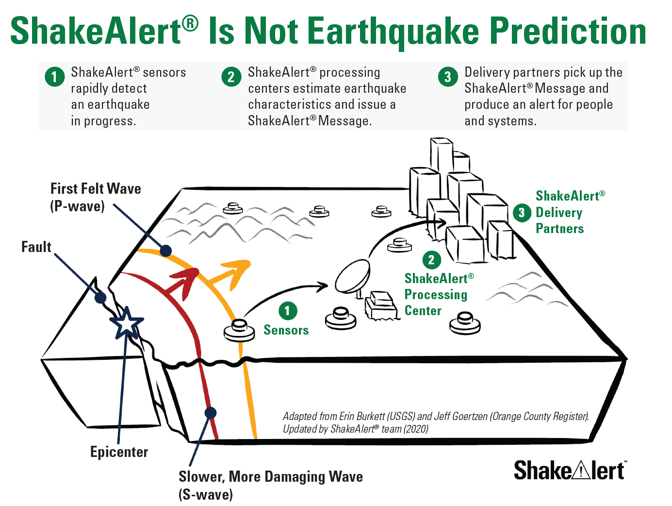
The ShakeAlert system components and sequence of events for early warning are illustrated: An earthquake occurs on a fault known to have caused earthquakes in the past, as a result, P-waves (the first felt compressional wave) are generated. P-waves travel faster through the Earth than S-waves, which are also generated in the earthquake and are more damaging because they are shear waves that cause the ground to move up and down violently. Faster arrival of P-waves to the regional grid of seismometers comprising the earthquake detection system allows for the determination of earthquake characteristics, such as location, depth, and magnitude. ShakeAlert processing centers instantly issue an automated ShakeAlert message to all end users and the public that damaging S-waves are coming seconds to a few tens of seconds before their arrival, which often allows for adequate mitigation measures to be taken. These seconds to tens of seconds warnings help minimize the effects of destructive earthquakes.
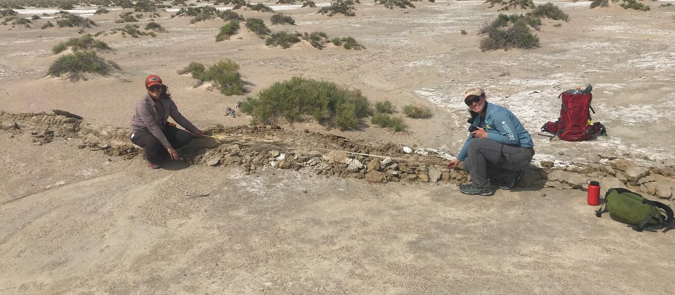
U.S. Geological Survey (USGS) geologists measure fault displacement along the principal rupture in Searles Valley, California as part of the 2019 Ridgecrest earthquake sequence. Photograph by Ben Brooks, USGS.
National Volcano Early Warning System
The National Volcano Early Warning System (NVEWS) is a national-scale plan to ensure that volcanoes are monitored at levels equal to their threats. Threat ranking incorporates the hazards posed by each volcano and the potential exposure of people, property, and infrastructure. The USGS categorizes potentially active U.S. volcanoes as Very High, High, Moderate, Low, and Very Low threat. Currently, many of the 161 potentially active volcanoes in the United States have insufficient monitoring systems, while others have obsolete equipment. The goal of NVEWS is to ensure that the most hazardous volcanoes are properly monitored with a variety of modern instruments (fig. 2) well before the onset of activity, making timely and accurate hazard forecasts possible minutes, days or even weeks before an eruption.
In addition, NVEWS seeks to advance several capabilities of the U.S. volcanology community through:
-
• Added staffing and automation to improve 24/7 monitoring of volcanoes and rapid response, and
-
• Integrated computer systems that distribute monitoring data and products to scientists, responding agencies, research institutions, and the public more efficiently.
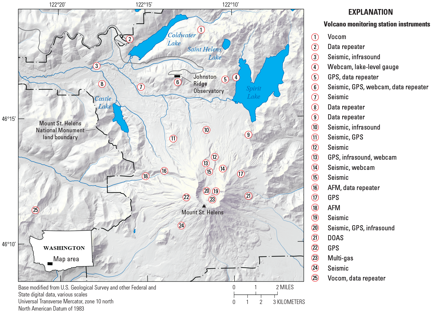
Map of National Volcano Early Warning System monitoring network on Mount St. Helens in Washington. Note the distribution of monitoring stations (numbered in map) around the summit and flanks of Mount St. Helens. The wide variety of ground-based sensors, including broadband seismometers, global positioning system, webcams, infrasound sensors, multi-gas sensors, and telemetry infrastructure are designed to detect all varieties of eruption precursors (ground deformation, increase in small earthquakes, changes in gas emission, steam explosions) minutes, days, to months before an eruption. This varied array of ground sensors allows for fingerprinting of normal background activity at each active volcano in the United States and for detection of departures from normal background activity at the earliest stage possible. The data collected from these sensors allows USGS volcano observatories to issue warnings and forecasts of eruptions, and for adequate mitigation measures to be taken by land managers, the public, and the aviation sectors. USGS capability to deliver forecasts and warnings of hazardous volcanic activity depends on adequate instrumentation installed on the volcano and thorough real-time data analysis by observatory scientific staff. Abbreviations: AFM, acoustic flow meter; GPS, global positioning system; DOAS, differential optical absorption spectrometry.
Similarities and Differences
NVEWS involves increasing the number and types of monitoring instruments—including seismometers and global positioning system (GPS) receivers like those used for EEW—for the Nation’s highest threat volcanoes. However, seismometer locations and early warning time frames are distinctly different for EEW and NVEWS. The two systems have different missions and technical requirements and will be operated independently. At select EEW sites, broadband seismometers and webcams can be added to provide NVEWS function. Volcano monitoring networks also include other types of ground-based sensors, which typically are not part of regional seismometer networks supporting EEW (fig. 2). Table 1 summarizes the many differences between EEW and NVEWS.
Table 1.
Summary of differences between Earthquake Early Warning (EEW) and the National Volcano Early Warning System (NVEWS).[GPS, global positioning system; mi, miles; M, magnitude]
While the two warning systems address different hazards that occur on different time scales, the data from seismic instruments in both systems may be similar and will be shared in real-time. They will assist the entire nation in addressing natural hazards, whether from earthquakes, volcanoes, or secondary hazards (for example, tsunamis or ground failure). This is especially important in areas of the country, such as California, the Pacific Northwest, and Alaska, where large damaging and tsunami-generating earthquakes can occur in proximity to active volcanic systems.
Seismic instruments deployed independently for NVEWS and EEW will help detect both tsunami-generating earthquakes and volcanic eruptions; real-time data from these instruments will be shared with Hawaii and Alaska's National Oceanic and Atmospheric Administration tsunami warning centers. In many remote areas, such as the Aleutian Islands, American Samoa, and the Commonwealth of the Northern Mariana Islands, the first indication of a large tsunamigenic earthquake or volcanic eruption may come from Global Seismic Network seismometers or those deployed as part of NVEWS on remote islands. Despite their distance from population centers and significant infrastructure, where much of EEW is focused, these seismometers are necessary because of potential threats posed by remote volcanoes to remote populations, civil and military aviation, and maritime vessels.

Two portable sensors: a strong motion sensor (to record strong shaking that can be felt) and a broadband sensor (to record weak motion for detecting small earthquakes) buried into the ground to detect earthquakes. These stations can be quickly deployed and send real-time data back to the U.S. Geological Survey via cellular telemetry immediately after they are installed.
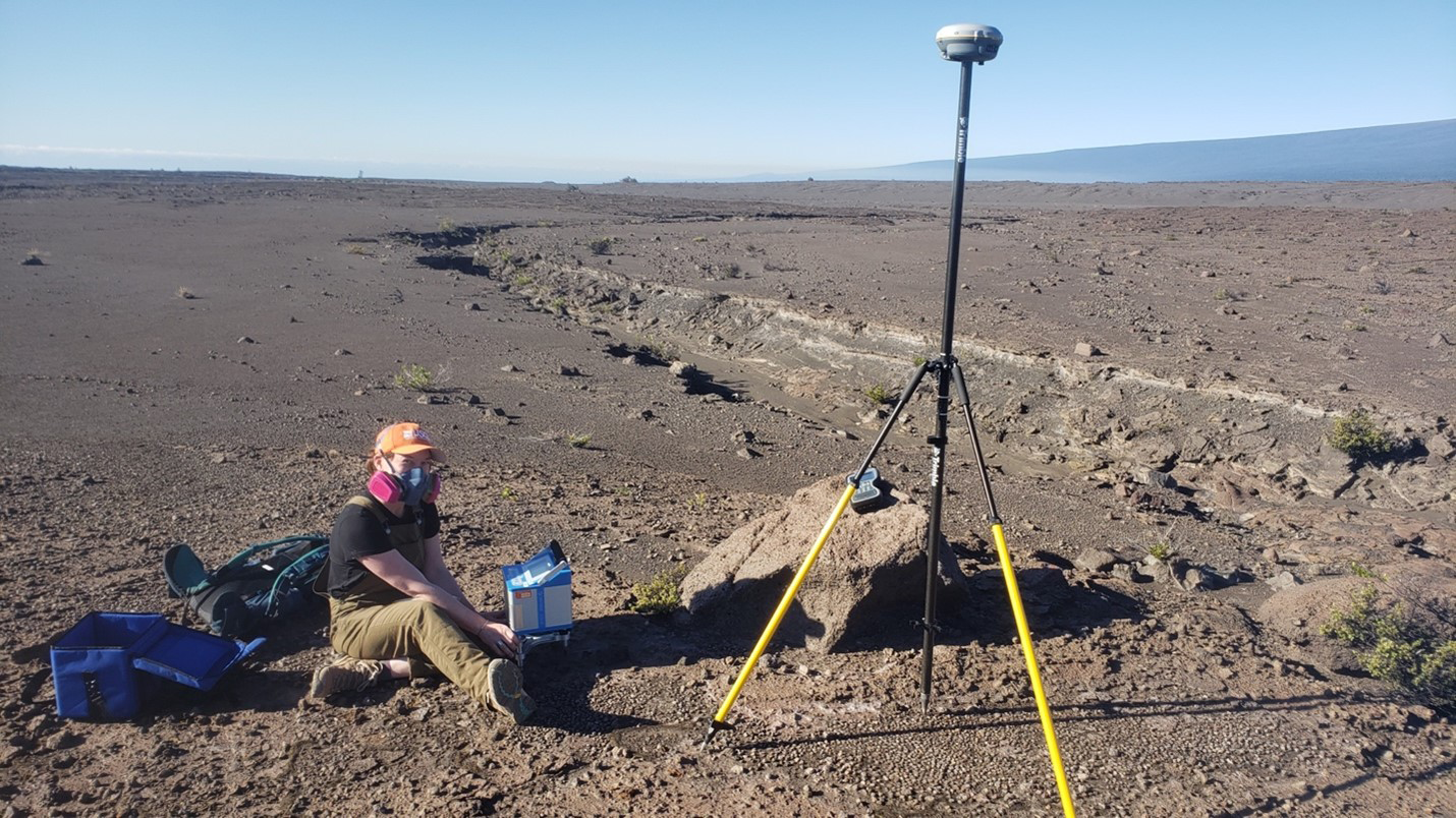
Scientist measuring variations in the strength of gravity (grey box) and precise location (global positioning system on antenna) at the summit of Kīlauea. Photograph taken on January 7, 2023, by Hawaiian Volcano Observatory geophysicist A. Flinders, U.S. Geological Survey.
Opportunities for VHP-EHP Collaboration
At each volcano, the VHP already leverages existing seismic and geodetic instrumentation maintained by the EHP, universities, States, and private organizations. During times of unrest, especially at under-monitored or low-threat volcanoes, these networks will be extremely important for hazard assessment until the regional networks are improved by a VHP response.
Volcano monitoring networks with multiple instrument types also help the USGS better identify whether earthquake swarms are being caused by volcanic activity. Ambiguity in the cause of an earthquake swarm can arise when a swarm is near a volcano or within a distributed volcanic field. To determine the ultimate origin and significance of increased seismicity, VHP and EHP scientists and their partners analyze seismic and other types of data from ground-based instruments (for example, pressure sensors, tiltmeters, GPS, gas emission, and web cameras) and data from satellites (such as, radar and gas emission).
In all instances, digital communications networks can be leveraged between EHP and VHP, as they already are in the Pacific Northwest, California, and Alaska. The two programs are in frequent communication, share some staff expertise and logistics, and take advantage of joint software and hardware development and equipment purchase contracts (for example, digital broadband seismometers and batteries bought in large orders as a cost-saving measure). Both programs are always looking for opportunities to leverage instrumentation and communication networks in a cost-effective manner to maximize the Nation’s resilience to earthquake and volcano hazards.

Background photograph. Instrumentation for the annual global positioning system (GPS) survey of Mauna Loa, completed by geophysicists at the Hawaiian Volcano Observatory. Photograph by A. Ellis, U.S. Geological Survey.
For more information, contact:
Associate Director for Natural Hazards
12201 Sunrise Valley Dr MS-905
Reston, VA 20192
https://www.usgs.gov/mission-areas/natural-hazards
All photographs by the U.S. Geological Survey
Disclaimers
Any use of trade, firm, or product names is for descriptive purposes only and does not imply endorsement by the U.S. Government.
Although this information product, for the most part, is in the public domain, it also may contain copyrighted materials as noted in the text. Permission to reproduce copyrighted items must be secured from the copyright owner.
Suggested Citation
Wilkins, A., Mandeville, C., Power, J., and Given, D., 2023, Comparison of earthquake early warning systems and the national volcano early warning system at the U.S. Geological Survey: U.S. Geological Survey Fact Sheet 2023-3033, 4 p., https://doi.org/10.3133/fs20233033.
ISSN: 2327-6932 (online)
ISSN: 2327-6916 (print)
| Publication type | Report |
|---|---|
| Publication Subtype | USGS Numbered Series |
| Title | Comparison of earthquake early warning systems and the national volcano early warning system at the U.S. Geological Survey |
| Series title | Fact Sheet |
| Series number | 2023-3033 |
| DOI | 10.3133/fs20233033 |
| Publication Date | August 15, 2023 |
| Year Published | 2023 |
| Language | English |
| Publisher | U.S. Geological Survey |
| Publisher location | Reston, VA |
| Contributing office(s) | Earthquake Science Center, Office of the AD Hazards, Volcano Hazards Program |
| Description | 4 p. |
| Online Only (Y/N) | N |
| Additional Online Files (Y/N) | N |