

The 3D Elevation Program—Supporting Florida’s Economy
Links
- Document: Report (1.55 MB pdf) , HTML , XML
- NGMDB Index Page: National Geologic Map Database Index Page (html)
- Download citation as: RIS | Dublin Core
Introduction
Florida has the longest coastline of any State in the contiguous United States, and its coastal resources are one of the main drivers of its economic growth, with 80 percent of the State’s population living in the coastal zone (Hapke and others, 2019). High-quality elevation data are beneficial for use in emergency management, especially for hurricane response, recovery, and mitigation, as well as for coastal zone management, flood risk management, infrastructure planning, agriculture, forestry, and natural resources management. Having regional or statewide elevation data coverage that was collected at about the same time allows for improved results from in-depth modeling and more meaningful analysis to support the State’s Chief Science Officer, Geographic Information Officer, State agencies, water management districts, and local governments that will use these data for decision making. Critical applications that meet the State’s management needs depend on light detection and ranging (lidar) data that provide a highly detailed three-dimensional (3D) model of the Earth’s surface and aboveground features.
The 3D Elevation Program (3DEP; refer to sidebar) is managed by the U.S. Geological Survey (USGS) in partnership with Federal, State, Tribal, U.S. territorial, and local agencies to acquire consistent lidar coverage at quality level 2 or better (table 1) to meet the many needs of the Nation and Florida. The status of available and in-progress 3DEP baseline lidar data in Florida is shown in figure 1. 3DEP baseline lidar data include quality level 2 or better, 1-meter or better digital elevation models, and lidar point clouds, and must meet the Lidar Base Specification version 1.2 (https://www.usgs.gov/3dep/lidarspec) or newer requirements. The National Enhanced Elevation Assessment (NEEA) (Dewberry, 2012) identified user requirements and conservatively estimated that availability of lidar data would result in at least $10.88 million in new benefits annually to the State. The top six Florida business uses for 3D elevation data, which are based on the estimated annual conservative benefits of 3DEP, are shown in table 2. The Florida Statewide Lidar Assessment (Dewberry, 2017), conducted in 2017, exceeded the NEEA-identified benefits by almost $10 million; it reported at least $20 million in new benefits annually to the State, with a need for topographic lidar coverage at quality level 1 (table 1). To meet this need, 3DEP in 2018 provided funding in partnership with the Florida Division of Emergency Management to acquire quality level 1 topographic lidar data over most of peninsular Florida to complement the existing lidar data available in the State.
Natural Resources Conservation
From restoring and protecting ecosystems of the Everglades to managing and protecting water resources, high-quality elevation data enable State, regional, Tribal, and local governments to better implement natural resources conservation practices while providing additional cost saving to the public. With increased lidar data availability statewide, public and private organizations can expand their use of lidar for planning and site-level engineering to reduce fieldwork for conservation ponds, grassed waterways, pipelines, and terracing, as well as accurately calculating runoff, identifying historical (drained) wetlands, and planning wetland restoration.
Flood Risk Management
Florida has a critical, ongoing requirement for high-resolution elevation data to support the mapping, monitoring, management, and protection of water resources for flood control, water supply, water quality, and natural systems. These efforts are of high priority for Florida’s water management districts and counties in supporting the safety of Florida residents during hazardous events. Lidar data provide the baseline for many flood and inundation models that can be used by the public to better understand their home’s flood risk, in addition to supporting advanced hydrologic and hydraulic modeling.
Infrastructure and Construction Management
When high-quality lidar data are readily available, the need for traditional topographic land surveys (including infrastructure and construction-site planning and estimates) may be minimized. Reducing the time required for project planning provides cost saving to the public. Lidar data can be used for preliminary highway alignment and design, for evaluating existing roadway conditions, as input to hydraulic modeling for the design of structures to accommodate runoff and flooding from large rain events, and for detecting subsidence (fig. 2). A statewide elevation dataset would facilitate communication and interoperability among transportation organizations and enhance cooperation at all levels of government.
Coastal Zone Management
Florida’s Office of Economic and Demographic Research conducted a study in January 2015 determining that nine features make up the “state brand.” Of those nine features, beaches are considered the most important, with investments to the Beach Management and Restoration Program generating a 5.4-to-1 return on investment (Florida Office of Economic and Demographic Research, 2015). Comprehensive lidar coverage enables the development of detailed modeling for protection of Florida’s coastlines by helping scientists and planners better understand the risks of sea-level rise, the impacts of storm surges, and the vulnerability of shallow tidal-water habitats—especially as those data relate to climate change and annual or post-hurricane beach nourishment efforts.
Table 1.
Data quality levels, pulse spacing, and pulse density. Quality level 2 or better lidar data meet 3DEP requirements.[Specifications for quality level 0 (QL0) are from Heidemann (2012, p. 3 and table 1); for quality levels 1 and 2, specifications are from Sugarbaker and others (2014, table 1). In the quality level column, QL0 represents the highest level of quality. RMSEz, root mean square error in the elevation (z) dimension; cm, centimeter; m, meter; pls/m2, first return pulses per square meter; ≤, less than or equal to; ≥, greater than or equal to]
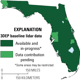
Map of Florida showing status of 3D Elevation Program (3DEP) baseline lidar data as of May 2023. Visit https://usgs.gov/NationalMap/LidarExplorer to find and download currently available data.
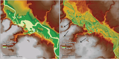
An area of significant sinkhole development near the Alapaha River in north-central Florida. Left, terrain model developed from USGS 1:24,000-scale topographic maps. Right, 5-foot-resolution lidar digital elevation model in which the sinkholes are more clearly distinguishable as pockmarks (indicated by black arrows) in the high-elevation areas. Images and description courtesy of Alan Baker, Florida Geological Survey.
Table 2.
Conservative benefits estimates for the top six Florida business uses of the proposed 3DEP data identified in the National Enhanced Elevation Assessment (Dewberry, 2012).3D Elevation Program (3DEP)
The 3D Elevation Program is managed by the U.S. Geological Survey (USGS) on behalf of the community of Federal, State, Tribal, local, and other partners and users of elevation data. In response to growing needs for high-quality elevation data, the goal of 3DEP is to complete acquisition of nationwide light detection and ranging (lidar) data (interferometric synthetic aperture radar [IfSAR] data in Alaska) to provide the first-ever national baseline of consistent, high-resolution topographic elevation data—both bare-earth digital elevation models and 3D point clouds.
Benefits
-
• Economies of scale by acquiring data for larger areas.
-
• Predictable and flexible Federal investmentsthat reduce costs and allow better planning.
-
• Consistent national coverage that provides data for applications that span project, jurisdictional, and watershed boundaries.
-
• Simplified data acquisition that provides contracts, project management, quality assurance, and published data specifications.
-
• National benefits of $690 million per year conservatively, with the potential to generate $13 billion per year in additional benefits through applications that span the economy (Dewberry, 2012).
High-Quality Data and Products
3DEP lidar data provide coverage with a minimum of two points per square meter and a vertical error not to exceed 10 centimeters, measured as root mean square error in the elevation (z) dimension (RMSEz) (table 1). 3DEP baseline lidar data products include all data points collected (point clouds) and bare-earth digital elevation models with a 1-meter or better resolution. The USGS integrates the elevation data into The National Map. Data are available free of charge and without use restrictions. To download 3DEP products visit https://apps.nationalmap.gov/downloader/.
Ways to Participate
Participation in 3DEP is open to Federal, State, Tribal, U.S. territorial, and local government partners, as well as private sector partners, and offers the option to acquire higher quality data. Partners may contribute funds toward projects managed by the USGS, or they may receive cooperative funds to manage their own projects. An annual Data Collaboration Announcement is the mechanism used to establish partner agreements. Organizations and the private sector may contribute existing data that meet 3DEP requirements. For more information refer to the 3DEP website at https://usgs.gov/3DEP/collaborate/.
References Cited
Dewberry, 2012, Final report of the National Enhanced Elevation Assessment (revised March 29, 2012): Fairfax, Va., Dewberry, 84 p. plus appendixes, accessed March 29, 2021, at https://www.dewberry.com/services/geospatial/national-enhanced-elevation-assessment.
Dewberry, 2017, Florida Statewide Lidar Assessment: Tampa, Dewberry, 56 p., accessed March 29, 2021, at https://publicfiles.dep.state.fl.us/FGS/GIS/LiDAR_Assessment/FL_LiDAR_Assessment_2017.pdf.
Florida Office of Economic and Demographic Research, 2015, Economic evaluation of Florida’s investment in beaches: Tallahassee, Florida Office of Economic and Demographic Research, 23 p., accessed April 2, 2021, at http://edr.state.fl.us/Content/returnoninvestment/BeachReport.pdf.
Hapke, C.J., Kramer, P.A., Fetherston-Resch, E.H., Baumstark, R.D., Druyor, R., Fredericks, X., and Fitos, E., 2019, Florida Coastal Mapping Program—Overview and 2018 workshop report: U.S. Geological Survey Open-File Report 2019–1017, 19 p., accessed March 23, 2021, at https://doi.org/10.3133/ofr20191017.
Heidemann, H.K., 2012, Lidar base specification (ver. 1.2, November 2014): U.S. Geological Survey Techniques and Methods, book 11, chap. B4, 67 p. with appendixes, accessed August 5, 2022, at https://doi.org/10.3133/tm11B4.
Sugarbaker, L.J., Constance, E.W., Heidemann, H.K., Jason, A.L., Lukas, V., Saghy, D.L., and Stoker, J.M., 2014, The 3D Elevation Program initiative—A call for action: U.S. Geological Survey Circular 1399, 35 p., accessed August 5, 2022, at https://doi.org/10.3133/cir1399.
For Further Information:
Director, National Geospatial Program
U.S. Geological Survey, MS 511
12201 Sunrise Valley Drive
Reston, VA 20192
Email: 3DEP@usgs.gov
USGS National Map Liaison: Xan Fredericks
Email: afredericks@usgs.gov
Disclaimers
Any use of trade, firm, or product names is for descriptive purposes only and does not imply endorsement by the U.S. Government.
Although this information product, for the most part, is in the public domain, it also may contain copyrighted materials as noted in the text. Permission to reproduce copyrighted items must be secured from the copyright owner.
Suggested Citation
Fredericks, A.M., and Cretini, C., 2024, The 3D Elevation Program—Supporting Florida's economy: U.S. Geological Survey Fact Sheet 2023–3037, 2 p., https://doi.org/10.3133/fs20233037.
ISSN: 2327-6932 (online)
Study Area
| Publication type | Report |
|---|---|
| Publication Subtype | USGS Numbered Series |
| Title | The 3D Elevation Program—Supporting Florida's economy |
| Series title | Fact Sheet |
| Series number | 2023-3037 |
| DOI | 10.3133/fs20233037 |
| Publication Date | February 20, 2024 |
| Year Published | 2024 |
| Language | English |
| Publisher | U.S. Geological Survey |
| Publisher location | Reston, VA |
| Contributing office(s) | National Geospatial Program |
| Description | 2 p. |
| Country | United States |
| State | Florida |
| Online Only (Y/N) | Y |
| Additional Online Files (Y/N) | N |