

The 3D Elevation Program—Supporting Montana’s Economy
Links
- Document: Report (995 KB pdf) , HTML , XML
- Download citation as: RIS | Dublin Core
Introduction
Montana, America’s fourth largest State with an area of 147,040 square miles, is defined by its diverse terrain. The western two-fifths of the State falls within the Rocky Mountains and the eastern three-fifths is in the Great Plains. Because of its location along the Continental Divide, the rivers in Montana drain into either the Pacific Ocean or the Gulf of Mexico. Montana is often called the Treasure State due to its mineral wealth, which includes oil, gas, and coal, but the State’s primary economic activity is agriculture. Other economic activities include natural resources conservation, water supply and quality, infrastructure and construction management, flood risk management, and geologic resource assessment and hazard mitigation. Critical applications that meet the State’s management needs depend on light detection and ranging (lidar) data that provide a highly detailed three-dimensional (3D) model of the Earth’s surface and aboveground features.
The 3D Elevation Program (3DEP; refer to sidebar) is managed by the U.S. Geological Survey (USGS) in partnership with Federal, State, Tribal, U.S. territorial, and local agencies to acquire consistent lidar coverage at quality level 2 or better (table 1) to meet the many needs of the Nation and Montana. The status of available and in-progress 3DEP baseline lidar data in Montana is shown in figure 1. 3DEP baseline lidar data include quality level 2 or better, 1-meter or better digital elevation models, and lidar point clouds, and must meet the Lidar Base Specification version 1.2 (https://www.usgs.gov/3dep/lidarspec) or newer requirements. The National Enhanced Elevation Assessment (Dewberry, 2012) identified user requirements and conservatively estimated that availability of lidar data would result in at least $13.08 million in new benefits annually to the State. Table 2 shows the top six Montana business uses for 3D elevation data, which are based on the estimated annual conservative benefits of 3DEP.
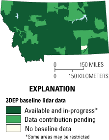
Map of Montana showing status of 3D Elevation Program (3DEP) baseline lidar data as of October 2023. Visit https://usgs.gov/NationalMap/LidarExplorer to find and download currently available data.
Table 1.
Data quality levels, pulse spacing, and pulse density. Quality level 2 or better lidar data meet 3DEP requirements.[Specifications for quality level 0 (QL0) are from Heidemann (2012, p. 3 and table 1); for quality levels 1 and 2, specifications are from Sugarbaker and others (2014, table 1). In the quality level column, QL0 represents the highest level of quality. RMSEz, root mean square error in the elevation (z) dimension; cm, centimeter; m, meter; pls/m2, first return pulses per square meter; ≤, less than or equal to; ≥, greater than or equal to]
Status of 3DEP in Montana
The Montana Lidar Plan sets a goal of statewide lidar data coverage (Montana State Library, 2019). Lidar in Montana is used by multiple business sectors, including Federal, State, Tribal, and local government, the private sector, nonprofit organizations, and the general public.
Agriculture and Precision Farming
Montana’s agribusiness and related industries produced $4.3 billion in annual revenue in 2021 (Montana Department of Agriculture, 2022). Wheat, hay, barley, lentils, and dry peas are the top crops by value of production. Lidar data support applications that are essential to this business area, including levee construction and reconstruction, wetland restoration, agricultural planning, management and 3D modeling of farmland (precision farming), and prevention of soil erosion.
Flood Risk Management
According to Steve Story (Chief, Water Operations Bureau, Montana Department of Natural Resources and Conservation, written commun., November 10, 2021), “Lidar is a necessary dataset to perform new flood hazard mapping studies compliant with Federal Emergency Management Agency guidelines and specifications. In general, quality level 2 (and preferably quality level 1) lidar data are required for accurate and credible flood-plain studies. Flood hazard studies cannot be accomplished in any area without lidar bare-earth datasets. Quality level 2 lidar data availability has enabled the Montana Department of Natural Resources and Conservation (DNRC) to undertake new mapping projects on a historic scale, with over half of the State’s flood-plain mapping portfolio (approximately 8,000 stream miles) under restudy. Refreshing the flood hazard and risk is DNRC’s primary mission and cannot be accomplished without the availability of quality level 2 or better lidar data.”
Geologic Resource Assessment and Hazard Mitigation
The Montana Bureau of Mines and Geology (MBMG) has a mandate to collect and publish information on Montana’s geology to promote orderly and responsible development of the energy, groundwater, and mineral resources of the State. Lidar has proved to be an essential source for examining areas for potential fieldwork, identifying new areas for mineral discovery, and uncovering areas of past mining activity. Recent lidar coverages have revealed previously unrecognized Quaternary faults (fig. 2) and landslides.
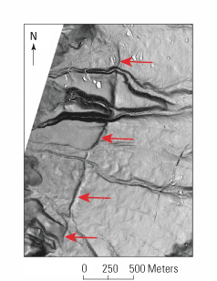
Image showing a slope-shade map derived from lidar data of the Quaternary-age Bitterroot fault offsetting multiple surfaces of the Ward Creek fan in the southern Bitterroot Valley of Montana (Stickney and Lonn, 2018). Red arrows indicate the fault trace. The Montana Bureau of Mines and Geology (MBMG) used lidar data to identify several geomorphic surfaces. Image courtesy of Mike Stickney, MBMG.
Table 2.
Conservative benefits estimates for the top six Montana business uses of the proposed 3DEP data identified in the National Enhanced Elevation Assessment (Dewberry, 2012).3DEP Elevation Program
The 3D Elevation Program is managed by the U.S. Geological Survey (USGS) on behalf of the community of Federal, State, Tribal, local, and other partners and users of elevation data. In response to growing needs for high-quality elevation data, the goal of 3DEP is to complete acquisition of nationwide light detection and ranging (lidar) data (interferometric synthetic aperture radar [IfSAR] data in Alaska) to provide the first-ever national baseline of consistent, high-resolution topographic elevation data—both bare-earth digital elevation models and 3D point clouds.
Benefits
-
• Economies of scale by acquiring data for larger areas.
-
• Predictable and flexible Federal investments that reduce costs and allow better planning.
-
• Consistent national coverage that provides data for applications that span project, jurisdictional, and watershed boundaries.
-
• Simplified data acquisition that provides contracts, project management, quality assurance, and published data specifications.
-
• National benefits of $690 million per year conservatively, with the potential to generate $13 billion per year in additional benefits through applications that span the economy (Dewberry, 2012).
High-Quality Data and Products
3DEP lidar data provide coverage with a minimum of two points per square meter and a vertical error not to exceed 10 centimeters, measured as root mean square error in the elevation (z) dimension (RMSEz) (table 1). 3DEP baseline lidar data products include all data points collected (point clouds) and bare-earth digital elevation models with a 1-meter or better resolution. The USGS integrates the elevation data into The National Map. Data are available free of charge and without use restrictions. To download 3DEP products visit https://apps.nationalmap.gov/downloader/.
Ways to Participate
Participation in 3DEP is open to Federal, State, Tribal, U.S. territorial, and local government partners, as well as private sector partners, and offers the option to acquire higher quality data. Partners may contribute funds toward projects managed by the USGS, or they may receive cooperative funds to manage their own projects. An annual Broad Agency Announcement is the mechanism used to establish partner agreements. Organizations and the private sector may contribute existing data that meet 3DEP requirements. For more information refer to the 3DEP website at https://usgs.gov/3DEP/collaborate/.
References Cited
Dewberry, 2012, Final report of the National Enhanced Elevation Assessment (revised March 29, 2012): Fairfax, Va., Dewberry, 84 p. plus appendixes, accessed June 15, 2022, at https://www.dewberry.com/services/geospatial/national-enhanced-elevation-assessment.
Heidemann, H.K., 2012, Lidar base specification (ver. 1.2, November 2014): U.S. Geological Survey Techniques and Methods, book 11, chap. B4, 67 p. with appendixes, accessed September 10, 2022, at https://doi.org/10.3133/tm11B4.
Montana Department of Agriculture, 2022, Montana Agricultural Statistics 2022: Montana Department of Agriculture, 57 p., accessed January 10, 2023, at https://www.nass.usda.gov/Statistics_by_State/Montana/Publications/Annual_Statistical_Bulletin/2022/Montana-Annual-Bulletin-2022.pdf.
Montana State Library, 2019, Montana Lidar Plan—A plan for statewide lidar acquisition, storage, and distribution: Montana State Library and Montana Department of Natural Resources and Conservation, ver. 0.2, June 2019, 42 p., accessed September 12, 2022, at https://docs.msl.mt.gov/Central_Services/Commission_Councils/Montana_Land_Information_Advisory_Council/Archive/2019/06/20190613_MontanaLidarPlan.pdf.
Stickney, M.C., and Lonn, J.D., 2018, Investigation of late Quaternary fault scarps along the Bitterroot fault in western Montana: Montana Bureau of Mines and Geology Report of Investigation 24, 16 p., accessed September 26, 2023, at https://mbmg.mtech.edu/pdf-publications/ri_24.pdf.
Sugarbaker, L.J., Constance, E.W., Heidemann, H.K., Jason, A.L., Lukas, V., Saghy, D.L., and Stoker, J.M., 2014, The 3D Elevation Program initiative—A call for action: U.S. Geological Survey Circular 1399, 35 p., accessed June 15, 2022, at https://doi.org/10.3133/cir1399.
For Further Information:
Director, National Geospatial Program
U.S. Geological Survey, MS 511
12201 Sunrise Valley Drive
Reston, VA 20192
Email: [email protected]
USGS National Map Liaison:
Tom Carlson; Email: [email protected]
Disclaimers
Any use of trade, firm, or product names is for descriptive purposes only and does not imply endorsement by the U.S. Government.
Although this information product, for the most part, is in the public domain, it also may contain copyrighted materials as noted in the text. Permission to reproduce copyrighted items must be secured from the copyright owner.
Suggested Citation
Carlson, T., 2023, The 3D Elevation Program—Supporting Montana’s economy: U.S. Geological Survey Fact Sheet 2023–3041, 2 p., https://doi.org/10.3133/fs20233041
ISSN: 2327-6932 (online)
Study Area
| Publication type | Report |
|---|---|
| Publication Subtype | USGS Numbered Series |
| Title | The 3D Elevation Program—Supporting Montana’s economy |
| Series title | Fact Sheet |
| Series number | 2023-3041 |
| DOI | 10.3133/fs20233041 |
| Publication Date | November 30, 2023 |
| Year Published | 2023 |
| Language | English |
| Publisher | U.S. Geological Survey |
| Publisher location | Reston, VA |
| Contributing office(s) | National Geospatial Program |
| Description | 2 p. |
| Country | United States |
| State | Montana |
| Online Only (Y/N) | Y |
| Additional Online Files (Y/N) | N |