

Development of a Surface-Water Index of Permanence to Assess Surface-Water Availability for Ecohydrological Refugia
Links
- Document: Report (2.5 MB pdf) , HTML , XML
- NGMDB Index Page: National Geologic Map Database Index Page (html)
- Download citation as: RIS | Dublin Core
Abstract
Surface-water availability has major implications for the environment and society in the 21st century. With climate change, increased drought severity, and altered water and land use, future water availability is predicted to continue to decline in many areas, including much of the western United States (Seager and others, 2013). An understanding of where and when water will be available at multiple scales is crucial for the planning and management of wildlife health, recreation, and energy development.
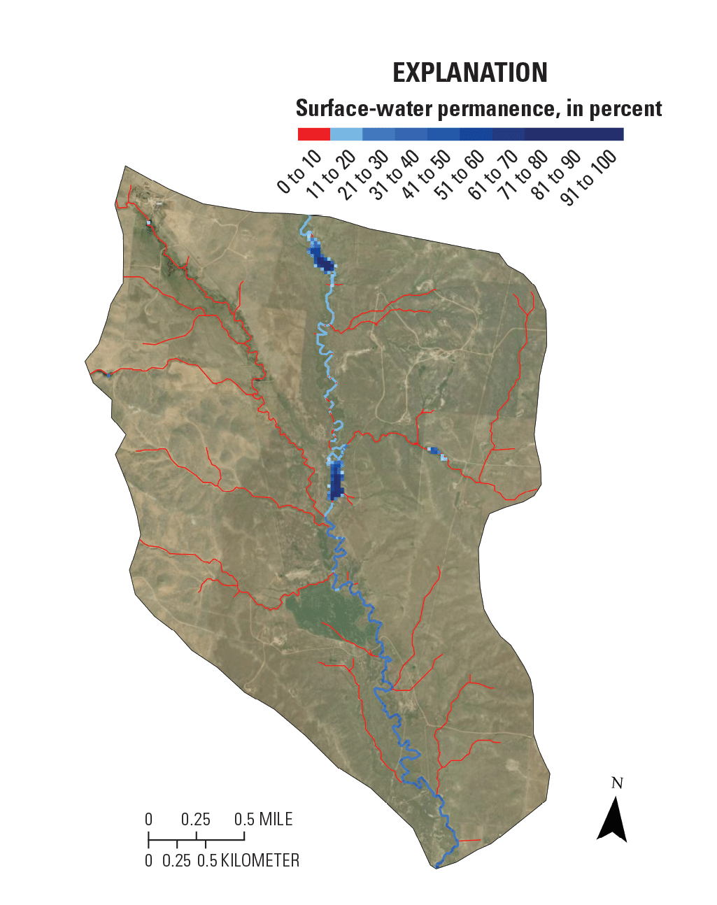
Currently, indices describing water presence and permanence exist for specific surface-water components (for example, streams and wetlands); however, a general surface-water permanence index that includes all major surface-water components is lacking. Developing a Surface-Water Index of Permanence (SWIPe) can provide a reliable metric to understand future river reach- to region-scale surface-water permanence and availability and inform land management and policy decisions.
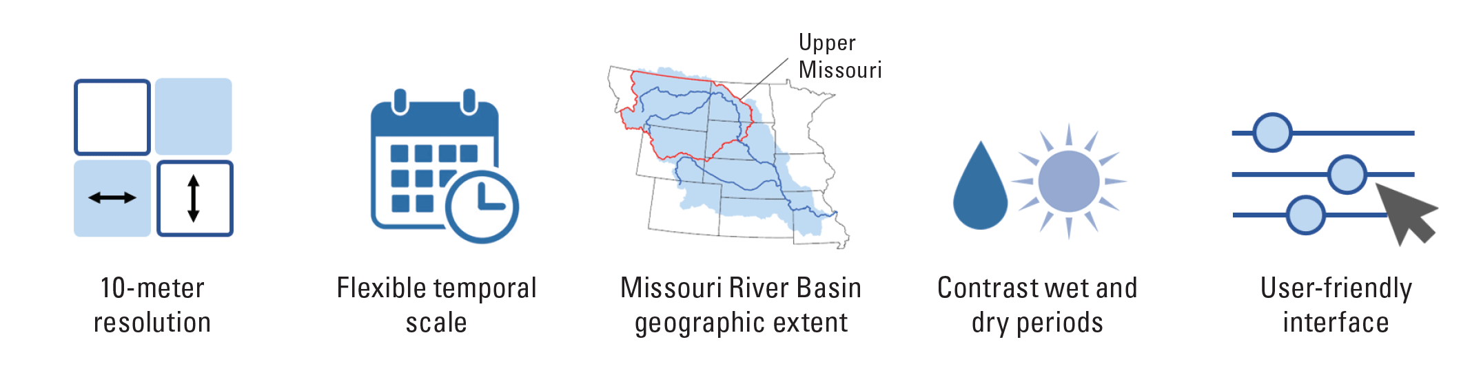
SWIPe is designed to cover the upper Missouri River Basin and combines three existing datasets: (1) the U.S. Geological Survey Dynamic Surface Water Extent (DSWE; Jones, 2019), (2) the U.S. Geological Survey Probability of Streamflow Permanence-Upper Missouri (PROSPERUM; Sando and others, 2022a), and (3) seasonal vegetation characteristics (Sando and others, 2022b) to identify likely groundwater/surface-water interaction locations.
SWIPe Development
SWIPe Datasets
Develop index from existing datasets:
-
• DSWE (Jones, 2019),
-
• PROSPERUM (Sando and others, 2022a), and
-
• Seasonal vegetation characteristics to identify potential groundwater/surface-water interaction (Sando and others, 2022b).
Links to Explore
-
• Projects—Climate Adaptation Science Centers (https://cascprojects.org/#/ and https://cascprojects.org/#/project/4f83509de4b0e84f60868124/624f510ed34e21f8276a0649).
-
• Explore DSWE science products (https://www.usgs.gov/landsat-missions/landsat-dynamic-surface-water-extent-science-products).
-
• Explore the PROSPERUM application (https://webapps.usgs.gov/prosperum/).
SWIPe Highlights
Ecological Application of SWIPe—Northern Leopard Frog Case Study
Historically, the Lithobates pipiens (Schreber, 1782; northern leopard frog; NLF) population is distributed across north-central North America (fig. 1), and populations east of the 100th meridian are considered stable. However, populations to the west of the 100th meridian are considered less stable based on genetic assessment (Stockwell and others, 2016), and the Rocky Mountain populations of NLF are listed as endangered under the Canadian Species at Risk Act. Historical population declines are largely attributed to overharvest of NLFs in the 1960s and 1970s for educational and research purposes (Gibbs and others, 1971), but recovery of NLFs in some regions is limited by climate change, invasive species, disease, and habitat loss and degradation (Stockwell and others, 2016). This species uses permanent and seasonal water sources for overwintering and breeding, respectively. Seasonal waterbodies are particularly important for recruitment and early life stages of the NLF, and permanently ponded waterbodies are essential for metapopulation connectivity. SWIPe and its associated products are planned to provide crucial information regarding availability of suitable habitat and the presence of permanent surface-water refugia for the NLF population across its northwestern distribution.
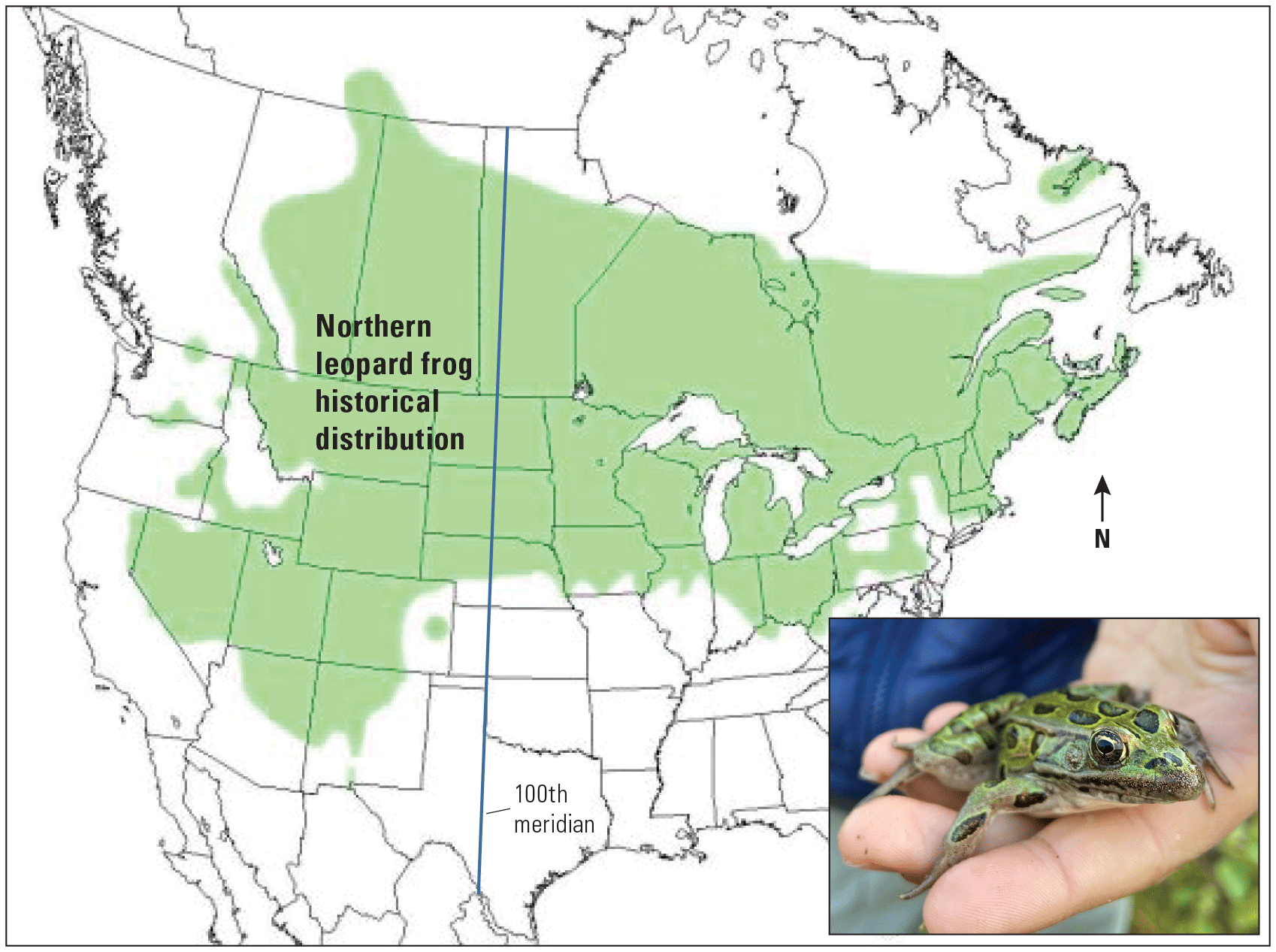
Probable historical distribution of Lithobates pipiens (Schreber, 1782; northern leopard frog; modified from Smith and Keinath [2007]). Inset photograph of adult northern leopard frog (photograph by Roy Sando, U.S. Geological Survey).
References Cited
Gibbs, E.L., Nace, G.W., and Emmons, M.B., 1971, The live frog is almost dead: BioScience, v. 21, no. 20, p. 1027–1034, accessed April 10, 2023, at https://doi.org/10.2307/1296057.
Jones, J.W., 2019, Improved automated detection of subpixel-scale inundation—Revised Dynamic Surface Water Extent (DSWE) partial surface water tests: Remote Sensing, v. 11, no. 4, p. 374. [Also available at https://doi.org/10.3390/rs11040374.]
Sando, R., Jaeger, K.L., Farmer, W.H., Barnhart, T.B., McShane, R.R., Welborn, T.L., Kaiser, K.E., Hafen, K.C., Blasch, K., York, B., and Shallcross, A., 2022a, Predictions and drivers of sub-reach-scale annual streamflow permanence for the upper Missouri River basin—1989–2018: Journal of Hydrology X, v. 17, art. 100138, 22 p., accessed March 27, 2023, at https://doi.org/10.1016/j.hydroa.2022.100138.
Sando, R., Siefken, S.A., and Heldmyer, A.J., 2022b, Probability of Streamflow Permanence (PROSPER) output rasters, 1989–2018, upper Missouri River Basin: U.S. Geological Survey data release, accessed March 27, 2023, at https://doi.org/10.5066/P93VL7HL.
Seager, R., Ting, M., Li, C., Naik, N., Cook, B., Nakamura, J., and Liu, H., 2013, Projections of declining surface-water availability for the southwestern United States: Nature Climate Change, v. 3, no. 5, p. 482–486. [Also available at https://doi.org/10.1038/nclimate1787.]
Smith, B.E., and Keinath, D.A., 2007, Northern leopard frog (Rana pipiens)—A technical conservation assessment: Forest Service, Rocky Mountain Region, Species Conservation Project, 66 p., accessed April 4, 2023, at https://www.fs.usda.gov/Internet/FSE_DOCUMENTS/stelprdb5182078.pdf.
Stockwell, C.A., Fisher, J.D., and McLean, K.I., 2016, Clinal patterns in genetic variation for northern leopard frog (Rana pipiens)—Conservation status and population histories: Wetlands, v. 36, p. 437–443, accessed April 4, 2023, at https://doi.org/10.1007/s13157-016-0847-3.
Contact Us
Director, Wyoming-Montana Water Science Center
U.S. Geological Survey
3162 Bozeman Avenue
Helena, MT 59601
Phone: (406) 457–5900
Email: [email protected]
Publishing support provided by the
Rolla Publishing Service Center
Disclaimers
Any use of trade, firm, or product names is for descriptive purposes only and does not imply endorsement by the U.S. Government.
Although this information product, for the most part, is in the public domain, it also may contain copyrighted materials as noted in the text. Permission to reproduce copyrighted items must be secured from the copyright owner.
Suggested Citation
Martin, A., Sando, R., Thurman, L., McLean, K., Wurster, P., Jones, J., and Sarbanes, A., 2023, Development of a Surface-Water Index of Permanence to assess surface-water availability for ecohydrological refugia: U.S. Geological Survey Fact Sheet 2023–3045, 2 p., https://doi.org/10.3133/fs20233045
ISSN: 2327-6932 (online)
| Publication type | Report |
|---|---|
| Publication Subtype | USGS Numbered Series |
| Title | Development of a Surface-Water Index of Permanence to assess surface-water availability for ecohydrological refugia |
| Series title | Fact Sheet |
| Series number | 2023-3045 |
| DOI | 10.3133/fs20233045 |
| Publication Date | October 13, 2023 |
| Year Published | 2023 |
| Language | English |
| Publisher | U.S. Geological Survey |
| Publisher location | Reston, VA |
| Contributing office(s) | Northern Rocky Mountain Science Center, Wyoming-Montana Water Science Center |
| Description | 2 p. |
| Online Only (Y/N) | Y |
| Additional Online Files (Y/N) | N |