

Assessment of Undiscovered, Technically Recoverable Conventional Oil and Gas Resources in the Upper Jurassic Smackover Formation, U.S. Gulf Coast, 2022
Links
- Document: Report (3.30 MB pdf) , HTML , XML
- Data Release: USGS data release - USGS National and Global Oil and Gas Assessment Project- Gulf Coast Smackover Conventional Oil and Gas Assessment Unit Boundaries, Assessment Input Data, and Fact Sheet Data Tables
- NGMDB Index Page: National Geologic Map Database Index Page (html)
- Download citation as: RIS | Dublin Core
Abstract
Using a geology-based assessment methodology, the U.S. Geological Survey estimated undiscovered, technically recoverable mean resources of 143 million barrels of oil and 1,084 billion cubic feet of natural gas in conventional accumulations for the Upper Jurassic Smackover Formation in the onshore U.S. Gulf Coast region.
Introduction
The U.S. Geological Survey (USGS) has conducted a quantitative assessment of the undiscovered, technically recoverable conventional oil and gas resources in reservoirs within the Upper Jurassic (Oxfordian) Smackover Formation across the onshore Gulf Coast basin, including State waters in Texas, Louisiana, Arkansas, Mississippi, Alabama, and Florida. The Smackover Formation is one of the most developed units within the Upper Jurassic–Cretaceous–Tertiary Composite Total Petroleum System (TPS; Condon and Dyman, 2006; fig. 1), with drilling and production activities dating back to the 1920s.
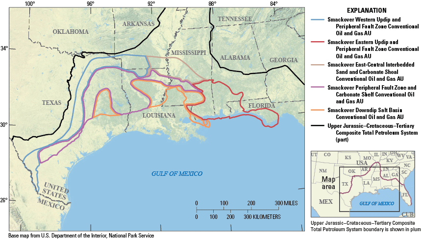
Map showing location of five Upper Jurassic Smackover Formation conventional oil and gas assessment units (AUs) in the U.S. Gulf Coast region.
Geologic Background
The Smackover Formation comprises strata deposited during a widespread marine transgression in the Gulf of Mexico Basin and formed a regionally extensive carbonate shelf during the Late Jurassic (Oxfordian; Salvador, 1991). Two informal intervals of the Smackover Formation are generally recognized. The lower part of the Smackover Formation (also informally named the Brown Dense shale), composed of organic-rich calcareous shales overlying the Upper Jurassic Norphlet Formation, serves as the source for oil and gas found in numerous overlying reservoirs, including the grain-supported limestones and packstones of the upper part of the Smackover. Though the formation is primarily regarded as calcareous, there are sandstone deposits in some landward areas, including central Mississippi, southeastern Arkansas, and northeastern Louisiana due to fluvial input. Porosity of carbonates in the upper part of the Smackover Formation is highly variable due to differences in ooid content and degree of dolomitization. A variety of diagenetic alteration processes include the influence of meteoric water generating gypsum brines from anhydrites of the Upper Jurassic Buckner Formation (Heydari, 2003). Differences in the petroleum system across the formation from east to west are apparent and related to variability in (1) heat flux affecting thermal history, (2) organic matter type affecting the timing of oil generation and petroleum properties, and (3) thermochemical sulfate reduction affecting hydrocarbon preservation.
Factors related to the technical recoverability of hydrocarbons in conventional Smackover Formation accumulations were accounted for in the development of assessment unit (AU) boundaries. Pressure and temperature limits on drilling were evaluated and determined based on published reports and information obtained from operators regarding the limitations of drilling and completion equipment (Whidden and others, 2023). Three-dimensional basin modeling was conducted using stratigraphic, lithologic, and temperature data (IHS Markit, 2021). The model established basin-wide burial history trends and helped delineate depths to maximum temperatures and pressures. Specifically, the assessment excluded areas where reservoirs were estimated to be beyond technically recoverable limits based on the presence of excessively high temperatures or pressures.
Assessment Units
The petroleum-system framework is the basis for defining assessment units (AUs) in the USGS assessment process. Based on this approach, five conventional AUs were defined in the Smackover Formation (fig. 1; table 1; Birdwell and Schenk, 2024). These AUs were differentiated based on four principal criteria: (1) spatial and stratigraphic variability in lithologies within the Smackover (Snedden and Galloway, 2019); (2) the presence and extent of peripheral faults, salt basins, and other structural features compiled from a wide range of sources; (3) thermal maturity boundaries based on vitrinite reflectance equivalence (VRoe, in percent) and gas-to-oil ratio data (IHS Markit, 2021), which determined the dominant form of petroleum present (oil or gas); and (4) degree of siliciclastic influence from the ancestral Mississippi River delta (Shew and Garner, 1990). The fourth factor has a complex impact on oil and gas prospects in the area of influence because it could account for additional conventional reservoirs, but it may also facilitate migration of oil and gas out of the Smackover Formation or dilute the source rock quality of the lower part of the Smackover. Additional field-scale petroleum system properties across the region were obtained from Nehring Associates Inc. (2018) and were also considered in defining AUs.
Table 1.
Key input data for five conventional oil and gas assessment units in the Upper Jurassic Smackover Formation, U.S. Gulf Coast region.[Shading indicates not applicable. AU, assessment unit; MMBO, million barrels of oil; BCFG, billion cubic feet of gas]
Both the Smackover Western and Eastern Updip and Peripheral Fault Zone Conventional Oil and Gas AUs are located within the extent of the inner platform ramp and carbonate shelf depositional environments defined and refined during the last 30 years (Snedden and Galloway, 2019 and references therein). These AUs are bounded to the north by the extent of deposition of the Smackover Formation in the onshore Gulf Coast or the onset of oil generation based on thermal maturity (greater than 0.55 percent VRoe) and gas-to-oil ratios calculated from cumulative production (greater than 20,000 cubic feet of natural gas per barrel of oil). They are bounded to the south by the downdip 1.78 percent VRoe thermal maturity boundary for oil to gas cracking or by State waters. Differences in the stratigraphy within the upper part of the Smackover (Budd and Loucks, 1981; Mancini and others, 2004; Heydari and Baria, 2006) and in properties of the organic matter in the lower part of the Smackover (Sassen, 1989) are distinguishing factors between these AUs. For example, microbialites have only been identified as important features in the Eastern Updip and Peripheral Fault Zone AU, mainly in southeastern Alabama.
The Smackover East-Central Interbedded Sandstone and Carbonate Shoal Conventional Oil and Gas AU is distinguished from the updip and peripheral fault zone AUs by the presence of a thick fluvial sandstone package deposited between them by the ancestral Mississippi River. It is also bounded to the north by the known extent of Smackover deposition and to the south by the 1.78 percent VRoe thermal maturity line.
The Smackover Peripheral Fault Zone and Carbonate Shelf Conventional Oil and Gas AU is located within the inner platform and carbonate shelf depositional environments but is defined to the north by the 1.78 percent VRoe thermal maturity boundary for gas generation. Downdip limits vary across the AU and are either defined by the extent of the inner platform ramp and carbonate shelf depositional environments or the limits of the modeled 260 degrees Celsius temperature or 25,000 pounds per square-inch pressure cutoff lines for technically recoverable conventional resources (cutoff is determined by whichever boundary is farthest inland from the coastline).
The Smackover Downdip Salt Basin Conventional Oil and Gas AU is defined to the north by the extent of carbonate ramp and shelf deposition and to the south by the technically recoverable boundaries related to temperature and pressure described above. The depositional environment for this AU is represented by the open shelf-outer platform described by Snedden and Galloway (2019). The Smackover Formation is currently undrilled in this area, but because of the anticipated absence of the reservoir facies typical of the upper part of the Smackover, traps and reservoirs are expected to be related to salt structures and debris flows carrying sands sourced from fluvial inputs.
Undiscovered, Technically Recoverable Resources Summary
The USGS assessed undiscovered, technically recoverable resources for five conventional AUs in the Smackover Formation of the U.S. Gulf Coast region. The estimated mean totals for conventional oil and gas resources (table 2) are 143 million barrels of oil (MMBO), with an F95–F5 range from 83 to 227 MMBO; 1,084 billion cubic feet of gas (BCFG), with an F95–F5 range from 393 to 2,317 BCFG; and 72 million barrels of natural gas liquids (MMBNGL), with an F95–F5 range from 26 to 154 MMBNGL.
Table 2.
Quantitative results for five conventional oil and gas assessment units in the Upper Jurassic Smackover Formation, U.S. Gulf Coast region.[Results shown are fully risked estimates. F95 represents a 95-percent chance of at least the amount tabulated; other fractiles are defined similarly. Shading indicates not applicable. MMBO, million barrels of oil; BCFG, billion cubic feet of gas; NGL, natural gas liquids; MMBNGL, million barrels of natural gas liquids]
For More Information
Assessment results are also available at the USGS Energy Resources Program website, at https://www.usgs.gov/programs/energy-resources-program.
References Cited
Birdwell, J.E., and Schenk, C.J., 2024, USGS Gulf Coast Petroleum Systems Project—Upper Jurassic Smackover Formation conventional resources, assessment unit boundaries, assessment input data, and fact sheet data tables: U.S. Geological Survey data release, available at https://doi.org/10.5066/P9YS1X7P.
Condon, S.M., and Dyman, T.S., 2006, 2003 geologic assessment of undiscovered conventional oil and gas resources in the Upper Cretaceous Navarro and Taylor Groups, Western Gulf Province, Texas: U.S. Geological Survey Digital Data Series DDS–69–H, chap. 2, 42 p., accessed February 4, 2021, at https://doi.org/10.3133/ds69H2.
Heydari, E., 2003, Meteoric versus burial control on porosity evolution of the Smackover Formation: Association of Petroleum Geologists Bulletin, v. 87, p. 1779–1797, accessed February 4, 2021, at https://doi.org/10.1306/07070302009.
IHS Markit, 2021, Enerdeq US well history and production database: Englewood, Colo., IHS Markit, accessed June 4, 2021, at https://www.ihsmarkit.com. [Available from IHS Markit, 15 Inverness Way East, Englewood, CO 80112.]
Salvador, A., 1991, Triassic–Jurassic, in Salvador, A., ed., The Gulf of Mexico Basin: Boulder, Colo., Geological Society of America, The Geology of North America, v. J, p. 131–180. [Also available at https://doi.org/10.1130/DNAG-GNA-J.389.]
Sassen, R., 1989, Migration of crude oil from the Smackover source rock to Jurassic and Cretaceous reservoirs of the northern Gulf rim: Organic Geochemistry, v. 14, no. 1, p. 51–60, accessed February 4, 2021, at https://doi.org/10.1016/0146-6380(89)90018-1.
Shew, R.D., and Garner, M.M., 1990, Reservoir characteristics of nearshore and shelf sandstones in the Jurassic Smackover Formation, Thomasville field, Mississippi, in Barwis, J.H., McPherson, J.G., and Studdick, J.R.J., eds., Sandstone petroleum reservoirs: New York, Springer-Verlag, p. 437–464, accessed February 4, 2021, at https://doi.org/10.1007/978-1-4613-8988-0_19.
Snedden, J.W., and Galloway, W.E., 2019, The Gulf of Mexico Sedimentary Basin—Depositional evolution and petroleum applications: Cambridge, U.K., Cambridge University Press, 326 p. [Also available at https://doi.org/10.1017/9781108292795.]
Whidden, K.W., Birdwell, J.E., Gardner, R.D., Kinney, S.A., Paxton, S.T., Pitman, J.K., Schenk, C.J., 2023, Assessment of continuous oil and gas resources in the Upper Jurassic Smackover Formation of the onshore U.S. Gulf Coast, 2022: U.S. Geological Survey Fact Sheet 2023–3021, accessed September 2023 at https://doi.org/10.3133/fs20233021.
Disclaimers
Any use of trade, firm, or product names is for descriptive purposes only and does not imply endorsement by the U.S. Government.
Although this information product, for the most part, is in the public domain, it also may contain copyrighted materials as noted in the text. Permission to reproduce copyrighted items must be secured from the copyright owner.
Suggested Citation
Birdwell, J.E., Whidden, K.J., Paxton, S.T., Kinney, S.A., Gardner, R.D., Pitman, J.K., French, K.L., Mercier, T.J., Woodall, C.A., Leathers-Miller, H.M., and Schenk, C.J., 2024, Assessment of undiscovered, technically recoverable conventional oil and gas resources in the Upper Jurassic Smackover Formation, U.S. Gulf Coast, 2022: U.S. Geological Survey Fact Sheet 2023–3046, 4 p., https://doi.org/10.3133/fs20233046.
ISSN: 2327-6932 (online)
Study Area
| Publication type | Report |
|---|---|
| Publication Subtype | USGS Numbered Series |
| Title | Assessment of undiscovered, technically recoverable conventional oil and gas resources in the Upper Jurassic Smackover Formation, U.S. Gulf Coast, 2022 |
| Series title | Fact Sheet |
| Series number | 2023-3046 |
| DOI | 10.3133/fs20233046 |
| Publication Date | January 16, 2024 |
| Year Published | 2024 |
| Language | English |
| Publisher | U.S. Geological Survey |
| Publisher location | Reston VA |
| Contributing office(s) | Central Energy Resources Science Center |
| Description | Report: 4 p.; Data Release |
| Country | United States |
| State | Alabama, Arkansas, Florida, Louisiana, Mississippi, Texas |
| Online Only (Y/N) | Y |