

The 3D Elevation Program—Supporting Minnesota’s Economy
Links
- Document: Report (1.17 MB pdf) , HTML , XML
- Download citation as: RIS | Dublin Core
Introduction
In Minnesota, high-quality elevation data are essential for agriculture and precision farming, natural resources conservation, flood risk management, infrastructure and construction management, water supply and quality, coastal zone management, and many other business uses. Critical applications that meet the State’s management needs depend on light detection and ranging (lidar) data that provide a highly detailed three-dimensional (3D) model of the Earth’s surface and aboveground features.
The 3D Elevation Program (3DEP; refer to sidebar) is managed by the U.S. Geological Survey (USGS) in partnership with Federal, State, Tribal, U.S. territorial, and local agencies to acquire consistent lidar coverage at quality level 2 or better (table 1) to meet the many needs of the Nation and Minnesota. The status of available and in-progress 3DEP baseline lidar data in Minnesota is shown in figure 1. 3DEP baseline lidar data include quality level 2 or better, 1-meter or better digital elevation models, and lidar point clouds, and must meet the Lidar Base Specification version 1.2 (https://www.usgs.gov/3dep/lidarspec) or newer requirements. The National Enhanced Elevation Assessment (Dewberry, 2012) identified user requirements and conservatively estimated that availability of lidar data would result in at least $13.6 million in new benefits annually to the State. The top 10 Minnesota business uses for 3D elevation data, which are based on the estimated annual conservative benefits of 3DEP, are shown in table 2.
Table 1.
Data quality levels, pulse spacing, and pulse density. Quality level 2 or better lidar data meet 3DEP requirements.[Specifications for quality level 0 (QL0) are from Heidemann (2012, p. 3 and table 1); for quality levels 1 and 2, specifications are from Sugarbaker and others (2014, table 1). In the quality level column, QL0 represents the highest level of quality. RMSEz, root mean square error in the elevation (z) dimension; cm, centimeter; m, meter; pls/m2, first return pulses per square meter; ≤, less than or equal to; ≥, greater than or equal to]
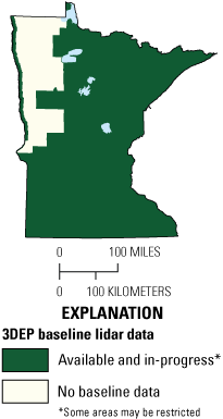
Map of Minnesota showing status of 3D Elevation Program (3DEP) baseline lidar data as of May 2023. Visit https://usgs.gov/NationalMap/LidarExplorer to find and download currently available data.
Status of 3DEP in Minnesota
The Minnesota Geospatial Advisory Council’s 3D Geomatics Committee (refer to text box), with guidance from the National States Geographic Information Council 3DEP for the Nation project, has written the Minnesota Lidar Plan (Minnesota Geospatial Advisory Council, 3D Geomatics Committee, 2021). The goals of the plan include (1) collection of quality level 1 lidar data, (2) collection of data statewide within about 5 years, and (3) development of more detail regarding lidar-derived information.
Water Supply and Quality
Detailed topographic information is essential to understanding the dynamics of water resources in Minnesota and knowing how to best mitigate human influences on the hydrologic systems, such as nutrient and sediment loading. Having updated elevation information at higher densities than previously available provides substantial time saving and greatly eases the identification of water conveyance features (fig. 2). Accurate modeling of the surface flow of water across the landscape is important for a myriad of applications, and high-density lidar provides the necessary detail for these applications.
“The 3D Geomatics Committee, chartered under the Minnesota Geospatial Advisory Council, is dedicated to identifying needs for planning, training, funding, acquisition, and management of three-dimensional geomatic data and derived products for Minnesota, and for promoting solutions to these needs. The committee members have expertise in creating lidar data standards, communicating with vendors, navigating big data management and dissemination, working with the USGS 3DEP, conducting geographic information system and lidar education, building stakeholder involvement, and developing foundational and authoritative datasets for general access and use. Members represent many sectors, including Federal, State, and local agencies, and the private sector.”
—Alison Slaats, Minnesota Geospatial Advisory Council, written commun., October 13, 2021
Forest Resources Management
Comprehensive forest inventory information is desired for multiple land uses and can be used in many applications, such as generating industry estimates of wood fiber and timber, assessing wildfire risk, and compiling foundational data for a host of other mitigation efforts in forest and habitat health monitoring. However, the costs of maintaining such information collected through fieldwork continue to be a large annual expense and long-term challenge. According to Jennifer Corcoran (Minnesota Department of Natural Resources, Remote Sensing Program, written commun., September 25, 2020), “The Minnesota Department of Natural Resources conducted a pilot study using high-density lidar data to create model-assisted forest inventory, showing that costs can be cut by about 55 percent, including the cost of lidar. This new approach enables the analysis of valuable three-dimensional information across all lands, not just State-administered lands.”
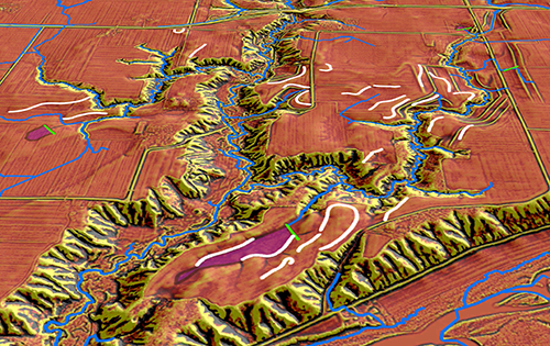
Hydrographic position index representation of water flow paths (blue) derived from a lidar-derived digital elevation model. Green and white lines represent areas where potential agricultural and conservation practices are best suited. Graphic courtesy of the Minnesota Department of Natural Resources.
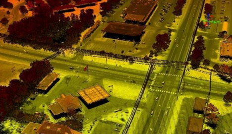
High-resolution digital surface model of an area in the city of White Bear Lake, Minnesota. Heavy black lines are power lines. Image provided by the Minnesota Department of Transportation.
Infrastructure and Construction Management
The Minnesota Department of Transportation has relied on aerial imagery, photogrammetry, and precision field data to create high-accuracy surveys for more than 40 years. However, these data have their limitations. Today’s lidar sensor technology and the capability of very high density scanning enables laser pulses to shoot through gaps in the forest canopy and reach the bare earth below. This allows engineers to use lidar-derived models to perform analyses of areas remotely, thereby reducing field time and safety risks. High-density lidar can also be used to identify archaeological sites and help avoid harmful impacts on them; calculate line of sight; determine the best location to build; accurately calculate cut-and-fill for road planning; identify heights of in-place assets; and, overall, identify and map streets, highways, railroads, grades, levees, buildings, and other constructed features in much greater detail and at a lower cost than ever before (fig. 3).
Table 2.
Conservative benefits estimates for the top 10 Minnesota business uses of the proposed 3DEP data identified in the National Enhanced Elevation Assessment (Dewberry, 2012).3D Elevation Program (3DEP)
The 3D Elevation Program is managed by the U.S. Geological Survey (USGS) on behalf of the community of Federal, State, Tribal, local, and other partners and users of elevation data. In response to growing needs for high-quality elevation data, the goal of 3DEP is to complete acquisition of nationwide light detection and ranging (lidar) data (interferometric synthetic aperture radar [IfSAR] data in Alaska) to provide the first-ever national baseline of consistent, high-resolution topographic elevation data—both bare-earth digital elevation models and 3D point clouds.
Benefits
-
• Economies of scale by acquiring data for larger areas.
-
• Predictable and flexible Federal investments that reduce costs and allow better planning.
-
• Consistent national coverage that provides data for applications that span project, jurisdictional, and watershed boundaries.
-
• Simplified data acquisition that provides contracts, project management, quality assurance, and published data specifications.
-
• National benefits of $690 million per year conservatively, with the potential to generate $13 billion per year in additional benefits through applications that span the economy (Dewberry, 2012).
High-Quality Data and Products
3DEP lidar data provide coverage with a minimum of two points per square meter and a vertical error not to exceed 10 centimeters, measured as root mean square error in the elevation (z) dimension (RMSEz) (table 1). 3DEP baseline lidar data products include all data points collected (point clouds) and bare-earth digital elevation models with a 1-meter or better resolution. The USGS integrates the elevation data into The National Map. Data are available free of charge and without use restrictions. To download 3DEP products visit https://apps.nationalmap.gov/downloader/.
Ways to Participate
Participation in 3DEP is open to Federal, State, Tribal, U.S. territorial, and local government partners, as well as private sector partners, and offers the option to acquire higher quality data. Partners may contribute funds toward projects managed by the USGS, or they may receive cooperative funds to manage their own projects. An annual Broad Agency Announcement is the mechanism used to establish partner agreements. Organizations and the private sector may contribute existing data that meet 3DEP requirements. For more information refer to the 3DEP website at https://usgs.gov/3DEP/collaborate/.
References Cited
Dewberry, 2012, Final report of the National Enhanced Elevation Assessment (revised March 29, 2012): Fairfax, Va., Dewberry, 84 p. plus appendixes, accessed July 8, 2022, at https://www.dewberry.com/services/geospatial/national-enhanced-elevation-assessment.
Heidemann, H.K., 2012, Lidar base specification (ver. 1.2, November 2014): U.S. Geological Survey Techniques and Methods, book 11, chap. B4, 67 p. with appendixes, accessed July 8, 2022, at https://doi.org/10.3133/tm11B4.
Minnesota Geospatial Advisory Council, 3D Geomatics Committee, 2021, Minnesota Lidar Plan: Minnesota Geospatial Advisory Council, 71 p., accessed July 8, 2022, at https://www.mngeo.state.mn.us/committee/3dgeo/acquisition/Minnesota_Lidar_Plan.pdf.
Sugarbaker, L.J., Constance, E.W., Heidemann, H.K., Jason, A.L., Lukas, V., Saghy, D.L., and Stoker, J.M., 2014, The 3D Elevation Program initiative—A call for action: U.S. Geological Survey Circular 1399, 35 p., accessed July 8, 2022, at https://doi.org/10.3133/cir1399.
For Further Information:
Director, National Geospatial Program
U.S. Geological Survey, MS 511
12201 Sunrise Valley Drive
Reston, VA 20192
Email: [email protected]
USGS National Map Liaison:
Mitch Bergeson; Email: [email protected]
Disclaimers
Any use of trade, firm, or product names is for descriptive purposes only and does not imply endorsement by the U.S. Government.
Although this information product, for the most part, is in the public domain, it also may contain copyrighted materials as noted in the text. Permission to reproduce copyrighted items must be secured from the copyright owner.
Suggested Citation
Bergeson, M.T., and Nail, D.S., 2023, The 3D Elevation Program—Supporting Minnesota's economy: U.S. Geological Survey Fact Sheet 2023–3047, 2 p., https://doi.org/10.3133/fs20233047
ISSN: 2327-6932 (online)
Study Area
| Publication type | Report |
|---|---|
| Publication Subtype | USGS Numbered Series |
| Title | The 3D Elevation Program—Supporting Minnesota's economy |
| Series title | Fact Sheet |
| Series number | 2023-3047 |
| DOI | 10.3133/fs20233047 |
| Publication Date | November 30, 2023 |
| Year Published | 2023 |
| Language | English |
| Publisher | U.S. Geological Survey |
| Publisher location | Reston, VA |
| Contributing office(s) | National Geospatial Program |
| Description | 2 p. |
| Country | United States |
| State | Minnesota |
| Online Only (Y/N) | Y |
| Additional Online Files (Y/N) | N |