

Assessment of undiscovered continuous oil and gas resources in Upper Cretaceous marine shales of the Raton Basin-Sierra Grande Uplift Province, Colorado and New Mexico, 2022
Links
- Document: Report (1.89 MB pdf) , HTML , XML
- Data Releases:
- USGS data release - Compilation of total organic carbon and pyrolysis analysis data for Cretaceous marine shales in the Raton Basin-Sierra Grande Uplift Province, Colorado and New Mexico
- USGS data release - USGS National and Global Oil and Gas Assessment Project—Raton Basin-Sierra Grande Uplift Province, Raton Continuous Resources: Assessment Unit Boundaries, Assessment Input Data, and Fact Sheet Data Tables
- NGMDB Index Page: National Geologic Map Database Index Page (html)
- Download citation as: RIS | Dublin Core
Abstract
Using a geology-based assessment methodology, the U.S. Geological Survey estimated means of 1.04 billion barrels of oil, 3.9 trillion cubic feet of gas, and 11 million barrels of natural gas liquids in Upper Cretaceous marine shales in the Raton Basin-Sierra Grande Uplift Province in Colorado and New Mexico.
Introduction
The U.S. Geological Survey (USGS) quantitatively assessed the potential for undiscovered, technically recoverable, continuous (unconventional) oil and gas resources in the Upper Cretaceous Niobrara Formation and Pierre Shale in the Raton Basin-Sierra Grande Uplift Province in Colorado and New Mexico (fig. 1). In the Raton Basin-Sierra Grande Uplift Province, the marine Niobrara Formation consists of two members: (1) the lower Fort Hays Limestone Member, composed of limestone and calcareous shale, and (2) the upper Smoky Hill Shale Member, composed of calcareous shale, sandy shale, and limestone (Scott, 1986; Scott and others, 1986; Broadhead, 2008). The Pierre Shale is predominantly medium-dark gray non-calcareous marine shale, with minor beds of limestone, siltstone, and fine-grained sandstone (Scott, 1986; Scott and Cobban, 1986; Broadhead, 2008). The strata were deposited in the Western Interior Seaway, which during much of the Cretaceous occupied an elongate north-south foreland basin that developed to the east of the North American Cordilleran orogenic belt (DeCelles, 2004). At its maximum extent, the Western Interior Seaway extended north-south for more than 3,000 miles and connected the Arctic Ocean to the Gulf of Mexico (Kauffman, 1977). The latest Cretaceous through early Eocene Laramide orogeny fragmented the central part of the foreland basin into numerous smaller basins. These smaller basins, such as the Raton Basin, were depocenters for the accumulation of thick synorogenic sediments during the Laramide orogeny (Lindsey, 1998).
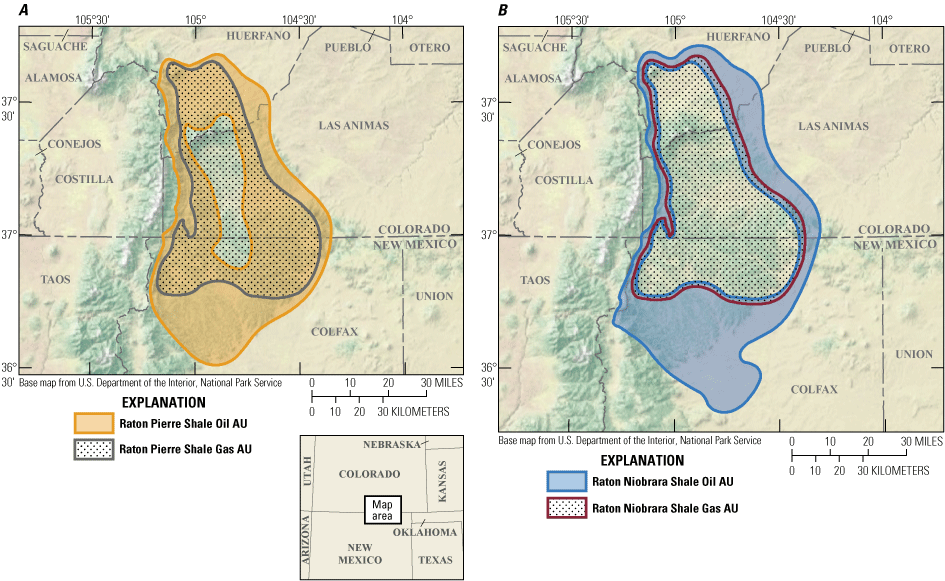
Maps showing the continuous oil and gas assessment units (AUs) in A, the Pierre Shale and B, the Niobrara Formation in the Raton Basin-Sierra Grande Uplift Province, Colorado and New Mexico.
Total Petroleum System and Assessment Unit
Schenk and others (2023) defined the Upper Paleozoic–Cenozoic Composite Total Petroleum System (TPS) in the Raton Basin-Sierra Grande Uplift Province to include strata from the base of the Pennsylvanian to the Paleocene Poison Canyon Formation. The Niobrara Formation and Pierre Shale are elements of the Upper Paleozoic–Cenozoic Composite TPS and include both source and reservoir rocks. According to Finn (2023), source rocks in the Niobrara Formation occur in the Smoky Hill Shale Member and have total organic carbon (TOC) contents as much as 6 weight percent and contain Type II and mixed Type II/III kerogen, with hydrogen index (HI) values as much as 586 milligrams of hydrocarbon per gram of TOC (mg HC/g TOC). Source rocks in the Pierre Shale are found in the Sharon Springs Member and have total TOC contents as much as 4 weight percent and contain Type II and mixed Type II/III kerogen, with HI values as much as 387 mg HC/g TOC (Gautier and others, 1984). Potential reservoirs are likely the carbonate-rich zones within the Niobrara Formation and the more brittle sandy and silty zones within the clay-rich Pierre Shale (Woodward, 1984, 1997). Natural fractures are expected to enhance reservoir productivity (Woodward, 1984, 1997; O’Farrell and others, 2010; Lorenz and Cooper, 2021). Thermal maturity mapping, based on vitrinite reflectance (Ro) of overlying coal-bearing strata, indicate that the Niobrara Formation and Pierre Shale are thermally mature for oil generation (0.6–1.35 percent Ro) along the shallow margins of the basin and mature for gas generation (greater than 1.35 percent Ro) in the deeper central parts of the basin (Tyler and others, 1995; Nuccio and others, 2002). The Laramide orogeny and post-Laramide burial is considered to have thermally matured these organic-rich shales (Woodward, 1997; Higley, 2004).
The geologic model for the Niobrara Formation and Pierre Shale continuous accumulations is for oil and gas to have been generated from oil-prone source rocks and partially retained following generation and migration into adjacent reservoirs. Four continuous assessment units (AUs) were defined: (1) the Raton Niobrara Shale Oil AU, (2) the Raton Niobrara Shale Gas AU, (3) the Raton Pierre Shale Oil AU, and (4) the Raton Pierre Shale Gas AU (fig. 1). The oil AUs encompass the area within the oil generation window (0.60–1.35 percent Ro), and the gas AUs include the area where oil has been cracked to gas (greater than 1.35 percent Ro).
Assessment input data are summarized in table 1 and in Finn (2024). Input data for estimated ultimate recoveries (EURs) of wells are based on the geologic analog in the Sand Wash Basin part of the Southwestern Wyoming Province.
Table 1.
Key input data for four continuous oil and gas assessment units in the Raton Basin-Sierra Grande Uplift Province.[The average estimated ultimate recovery (EUR) input is the minimum, median, maximum, and calculated mean. Gray shading indicates not applicable. AU, assessment unit; %, percent; MMBO, million barrels of oil; BCFG, billion cubic feet of gas]
Undiscovered Resources Summary
The USGS quantitatively assessed continuous oil and gas resources in four assessment units (table 2). For total undiscovered, technically recoverable continuous oil and gas resources in four AUs, the estimated means are 1,035 million barrels of oil (MMBO), with an F95–F5 fractile range from 249 to 2,173 MMBO; 3,943 billion cubic feet of gas (BCFG), with an F95–F5 fractile range from 1,135 to 7,391 BCFG; and 11 million barrels of natural gas liquids (MMBNGL), with an F95–F5 fractile range from 2 to 22 MMBNGL.
Table 2.
Results for four continuous oil and gas assessment units in the Raton Basin-Sierra Grande Uplift Province.[Results shown are fully risked estimates. F95 represents a 95-percent chance of at least the amount tabulated; other fractiles are defined similarly. Gray shading indicates not applicable. MMBO, million barrels of oil; BCFG, billion cubic feet of gas; NGL, natural gas liquids; MMBNGL, million barrels of natural gas liquids]
For More Information
Assessment results are available at the USGS Energy Resources Program website, http://energy.usgs.gov/oilgas/.
Raton Basin Assessment Team
Thomas M. Finn, Christopher J. Schenk, Tracey J. Mercier, Cheryl A. Woodall, Heidi M. Leathers–Miller, Phuong A. Le, Andrea D. Cicero, Geoffrey S. Ellis, Michael H. Gardner, Sarah E. Gelman, Jane S. Hearon, Benjamin G. Johnson, Scott A. Kinney, Jenny H. Lagesse, Kira K. Timm, Scott S. Young
References Cited
DeCelles, P.G., 2004, Late Jurassic to Eocene evolution of the Cordilleran thrust belt and foreland basin system, western U.S.A: American Journal of Science, v. 304, no. 2, p. 105–168. [Also available at https://doi.org/10.2475/ajs.304.2.105.] https://doi.org/10.2475/ajs.304.2.105
Finn, T.M., 2023, Compilation of total organic carbon and pyrolysis analysis data for Cretaceous marine shales in the Raton Basin-Sierra Grande Uplift Province, Colorado and New Mexico: U.S. Geological Survey data release, https://doi.org/10.5066/P9U9I10S.
Finn, T.M., 2024, USGS National and Global Oil and Gas Assessment Project—Raton Basin-Sierra Grande Uplift Province, Raton Continuous Resources, assessment unit boundaries, assessment input data, and fact sheet data tables: U.S. Geological Survey data release, https://doi.org/10.5066/P9CZ8DIC.
Gautier, D.L., Clayton, J.L., Leventhal, J.S., and Reddin, N.J., 1984, Origin and source-rock potential of the Sharon Springs Member of the Pierre Shale, Colorado and Kansas, in Woodward, J., Meissner, F.F., and Clayton, J.L., eds., Hydrocarbon source rocks of the greater Rocky Mountain region: Rocky Mountain Association of Geologists Guidebook, p. 369–385, accessed February 2, 2023, at https://archives-datapages-com.usgslibrary.idm.oclc.org/data/rmag/SourceRocks84/gautier.pdf.
Higley, D.K., 2004, Petroleum Systems and assessment of undiscovered oil and gas in the Raton Basin-Sierra Grande Uplift Province, Colorado and New Mexico, chap. 2 of Higley, D.K., compiler, Petroleum systems and assessment of undiscovered oil and gas in the Raton Basin-Sierra Grande Uplift Province, Colorado and New Mexico—USGS Province 41: U.S. Geological Survey Digital Data Series DDS–69–N, 38 p.
Lorenz, J.C., and Cooper, S.P., 2021, Natural fractures and their relationships to structure, stress, and permeability in the Raton Basin: The Mountain Geologist, v. 58, no. 4, p. 375–410, accessed April 1, 2022, at https://doi.org/10.31582/rmag.mg.58.4.375.
Nuccio, V.F., Johnson, R.C., and Finn, T.M., 2002, Preliminary surface vitrinite reflectance map of the Raton Basin, Colorado and New Mexico, in Schwochow, S.D., and Nuccio, V.F., eds., Coalbed methane of North America, II: Rocky Mountain Association of Geologists, p. 49–52, accessed February 9, 2023, at https://archives-datapages-com.usgslibrary.idm.oclc.org/data/rmag/CBM2/nuccio2.pdf.
O’Farrell, C., Hawkins, S., Drake, W., Soetrisno, H., and Peters, T., 2010, Spatial variability of fracture-enhanced shale-gas production—Insights from the Raton Basin, CO [abs.] in 2010 AAPG Rocky Mountain Section Meeting, Durango, Colo., June 13–16 [Proceedings]: AAPG Search and Discovery, article 90106, 1 p., accessed February 2, 2023, at https://www.searchanddiscovery.com/pdfz/abstracts/pdf/2010/rms/abstracts/ndx_ofarrell.pdf.html.
Schenk, C.J., Finn, T.M., Mercier, T.J., Woodall, C.A., Le, P.A, Cicero, A.D., Drake II, R.M., Ellis, G.S., Gardner, M.H., Gelman, S.E., Hearon, J.S., Johnson, B.G., Lagesse, J.H., Leathers-Miller, H.M., Marra, K.R., Timm, K.K., and Young, S.S., 2023, Assessment of coalbed gas resources in the Raton Basin-Sierra Grande Uplift Province, Colorado and New Mexico, 2022: U.S. Geological Survey Fact Sheet 2023-3020, 4 p., accessed July 6, 2023, at https://doi.org/10.3133/fs20233020.
Tyler, R., Kaiser, W.R., Scott, A.R., Hamilton, D.S., and Ambrose, W.A., 1995, Geologic and hydrologic assessment of natural gas from coal—Greater Green River, Piceance, Powder River, and Raton Basins, Western United States: The University of Texas at Austin, Bureau of Economic Geology, Report of Investigations, no. 228, 219 p.
Woodward, L.A., 1997, Role of regional tectonic analysis in exploration for fracture reservoirs in Cretaceous source rocks of the Raton Basin, New Mexico: The Mountain Geologist, v. 34, no. 2, p. 73–80, https://archives-datapages-com.usgslibrary.idm.oclc.org/data/rmag/mg/1997/woodward.pdf.
Disclaimers
Any use of trade, firm, or product names is for descriptive purposes only and does not imply endorsement by the U.S. Government.
Although this information product, for the most part, is in the public domain, it also may contain copyrighted materials as noted in the text. Permission to reproduce copyrighted items must be secured from the copyright owner.
Suggested Citation
Finn, T.M., Schenk, C.J., Mercier, T.J., Woodall, C.A., Leathers–Miller, H.M., Le, P.A., Cicero, A.D., Ellis, G.S., Gardner, M.H., Gelman, S.E., Hearon, J.S., Johnson, B.G., Kinney, S.A., Lagesse, J.H., Timm, K.K., Young, S.S., 2024, Assessment of undiscovered continuous oil and gas resources in Upper Cretaceous marine shales of the Raton Basin-Sierra Grande Uplift Province, Colorado and New Mexico, 2022: U.S. Geological Survey Fact Sheet 2023–3049, 4 p., https://doi.org/10.3133/fs20233049.
ISSN: 2327-6932 (online)
Study Area
| Publication type | Report |
|---|---|
| Publication Subtype | USGS Numbered Series |
| Title | Assessment of undiscovered continuous oil and gas resources in Upper Cretaceous marine shales of the Raton Basin-Sierra Grande Uplift Province, Colorado and New Mexico, 2022 |
| Series title | Fact Sheet |
| Series number | 2023-3049 |
| DOI | 10.3133/fs20233049 |
| Publication Date | January 18, 2024 |
| Year Published | 2024 |
| Language | English |
| Publisher | U.S. Geological Survey |
| Publisher location | Reston VA |
| Contributing office(s) | Central Energy Resources Science Center |
| Description | Report: 4 p.; 2 Data Releases |
| Country | United States |
| State | Colorado, New Mexico |
| Online Only (Y/N) | Y |