

Assessment of Undiscovered Conventional Oil and Gas Resources in Postsalt Reservoirs of the West-Central Coastal Province of Africa, 2022
Links
- Document: Report (744 KB pdf) , HTML , XML
- Data Release: USGS data release - USGS National and Global Oil and Gas Assessment Project–West-Central Coastal Province (Africa) Postsalt Reservoirs: Assessment Unit Boundaries, Assessment Input Data, and Fact Sheet Data Tables
- Download citation as: RIS | Dublin Core
Abstract
Using a geology-based assessment methodology, the U.S. Geological Survey estimated undiscovered, technically recoverable mean conventional resources of 10.5 billion barrels of oil and 47.4 trillion cubic feet of gas in postsalt reservoirs within the West-Central Coastal Province of Africa.
Introduction
The U.S. Geological Survey (USGS) assessed undiscovered, technically recoverable conventional oil and gas resources in the Douala-Rio Muni, Gabon, Congo, Kwanza-Benguela, and Namibe Basins of the West-Central Coastal Province of Africa (fig. 1). The assessment focused on the potential for undiscovered conventional oil and gas resources in reservoirs that are stratigraphically younger than the regionally extensive layer of late Aptian salt (“postsalt” reservoirs).
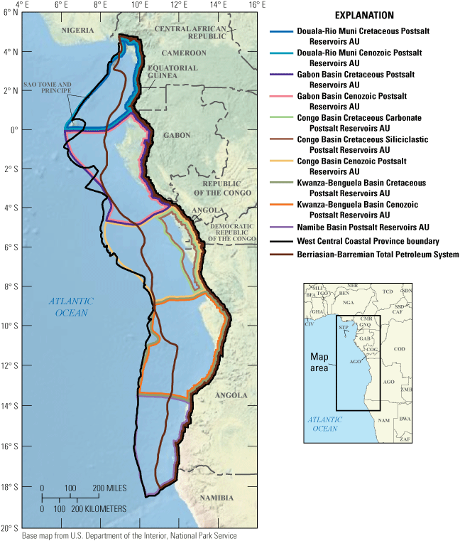
Map showing 10 conventional postsalt assessment units (AUs) in the West-Central Coastal Province.
The tectonic evolution of the West-Central Coastal Province began with the separation of Africa from South America in the Late Jurassic to Early Cretaceous (Torsvik and others, 2009; Guiraud and others, 2010; Matos and others, 2021; Matos, 2021). Rifting formed a broad, complex region of horsts and grabens that occur throughout the length of the West Central Coastal Province (Jackson and Hudec, 2009; Baudino and others, 2018). As rifting waned in the Early Cretaceous, thermal subsidence formed accommodation space (or “sag”) that filled with regionally extensive fluvial and lacustrine sediments. A series of transgressions beginning in the late Aptian caused marine waters to intermittently flow over the Walvis Ridge and across extended continental crust where evaporation led to the deposition of more than 1 kilometer of late Aptian salt (Greenhalgh and others, 2012). The cessation of rifting was followed by initiation of seafloor spreading in latest Aptian and the passive margin phase of west-central Africa. Transgression in the Albian formed extensive carbonate platforms with deposition of off-platform mudstones and marls, including Cenomanian to Turonian organic-rich shales. Santonian to Eocene deposition along the margin alternated between thin, prograding clastic sequences and carbonate platforms. Uplift of the cratonic margin in the Oligocene resulted in a major progradation of clastic sequences that provide most of the major reservoirs in the Mesozoic–Cenozoic Total Petroleum System. The definitions of assessment units were based on this general framework of reservoir development. Cretaceous carbonates were separated into assessment units, as were Paleogene and Neogene siliciclastic sequences.
Total Petroleum System and Assessment Units
The USGS defined a Mesozoic–Cenozoic Composite Total Petroleum System (TPS) and 10 conventional assessment units (AUs) within this TPS (fig. 1). The AUs in general share similar petroleum system elements of source rocks, reservoirs rocks, trap types, seals, and timing of oil and gas generation and migration (Beglinger and others, 2012), but the elements differ in detail between basins. Hydrocarbon source rocks within the Mesozoic–Cenozoic Composite TPS include Berriasian to Barremian synrift organic-rich lacustrine shales with Type I and II organic matter, have total organic carbon (TOC) content up to 20 weight percent, have hydrogen index (HI) values up to 800 milligrams of hydrocarbon per gram of TOC (mg HC/g TOC), and are as much as 600 meters (m) thick (Brownfield and Charpentier, 2006; Greenhalgh and others, 2012). Cenomanian to Turonian source rocks have Type II marine organic matter, have up to 10 weight percent TOC, have HI values up to 450 mg HC/g TOC, and are up to 30 m thick (Anka and others, 2010). Paleocene to Miocene shales have mixed Types II/III organic matter, have TOC values up to 5 weight percent, have HI values up to 400 mg HC/g TOC, and are as much as 40 m thick.
Postsalt reservoirs include Albian to Coniacian platform-margin carbonate reservoirs, including reefs, buildups, dolomites, and karst zones (Fort and others, 2004; Guiraud and others, 2010). Clastic sediments that bypassed the platforms during sea-level lowstands formed minor slope-channel and basin-floor reservoirs. Santonian to Eocene progradation of clastic systems during an overall sea-level highstand resulted in shelf, slope-channel, and basin-floor sandstones encased in shales. A major clastic sequence prograded offshore beginning in the Oligocene. This sequence was related to uplift and westward tilting of the cratonic margin. Extensive stacked slope-channel and basin-floor fan reservoirs that were deposited during this time form the major oil and gas reservoirs in the Congo, Gabon, and Kwanza-Benguela Basins. Deformation of Aptian salt was concurrent with the progradation of clastic sequences since the Albian, which influenced sediment transport pathways, depositional sites of sandstones, and formation of minibasins (Brownfield and Charpentier, 2006). Salt deformation was caused by sediment loading and by gravitational sliding as the cratonic margin was uplifted and tilted westward, notably during the Albian to Cenomanian and the Oligocene to Holocene.
Traps throughout the Mesozoic–Cenozoic Composite TPS are strongly influenced by continuous salt deformation. Traps within Cretaceous carbonates are mainly stratigraphic, but structural traps were created by the downslope movement and subsequent deformation of carbonate blocks. The progradation of clastic sequences occurred coeval with salt mobilization, in which salt diapirs, pillars, and overhangs influenced sediment transport paths and depositional sites, especially for slope-channel and basin-floor fans. Gravity sliding of salt created extensional traps updip, and contractional structures downdip, including folds, faults, anticlines, and thrust structures within the sandstones (Fort and others, 2004). Most structures have potentially been modified by continuous salt movement, and fluid movement likewise may also be continuous (Andresen and others, 2011; Anderson and others, 2012), leading to remigration or potential loss of fluids.
The differences in sediment thicknesses and burial, heat flow, and source-rock quality and distribution across the composite TPS led to spatial and temporal variations in thermal maturity. In general, the synrift lacustrine source rocks reached maturity for oil generation in the Aptian; oil generation may have begun from synrift lacustrine shales in the Aptian, and gas generation may have begun in the Oligocene (Brownfield and Charpentier, 2006).
The AUs defined in this assessment are based on the tectonic and stratigraphic evolution of the West-Central Coastal Province. To reflect the different groups and types of postsalt reservoir strata that were deposited during the Cretaceous and in the Paleogene to Neogene, the Douala-Rio Muni Cretaceous Postsalt Reservoirs AU, the Douala-Rio Muni Cenozoic Postsalt Reservoirs AU, the Gabon Basin Cretaceous Postsalt Reservoirs AU, the Gabon Basin Cenozoic Postsalt Reservoirs AU, the Congo Basin Cretaceous Carbonate Postsalt Reservoirs AU, the Congo Basin Cretaceous Siliciclastic Postsalt Reservoirs AU, the Congo Basin Cenozoic Postsalt Reservoirs AU, the Kwanza-Benguela Cretaceous Postsalt Reservoirs AU, the Kwanza-Benguela Cenozoic Postsalt Reservoirs AU, and the Namibe Basin Postsalt Reservoirs AU were defined within the Mesozoic–Cenozoic Composite TPS (fig. 1). Assessment input data are summarized in table 1 and in Schenk (2024).
Table 1.
Key input data for 10 conventional postsalt assessment units in the West Central Coastal Province.[Gray shading indicates not applicable. AU, assessment unit; MMBO, million barrels of oil; BCFG, billion cubic feet of gas]
Undiscovered Resources Summary
The USGS quantitatively assessed oil and gas resources in 10 conventional AUs in five basins of the West-Central Coastal Province (table 2). For undiscovered, technically recoverable conventional oil and gas resources, the mean totals are 10,518 million barrels of oil (MMBO), or 10.5 billion barrels of oil, with an F95 to F5 fractile range from 3,759 to 22,446 MMBO; 47,411 billion cubic feet of gas (BCFG), or 47.4 trillion cubic feet of gas, with an F95 to F5 fractile range from 17,311 to 100,896 BCFG; and 1,059 million barrels of natural gas liquids (MMBNGL), or 1.0 billion barrels, with an F95 to F5 fractile range from 384 to 2,258 MMBNGL.
Table 2.
Results for 10 conventional postsalt assessment units in the West-Central Coastal Province.[Results shown are fully risked estimates. F95 represents a 95-percent chance of at least the amount tabulated; other fractiles are defined similarly. Gray shading indicates not applicable. MMBO, million barrels of oil; BCFG, billion cubic feet of gas; NGL, natural gas liquids; MMBNGL, million barrels of natural gas liquids]
For More Information
Assessment results are also available at the USGS Energy website, https://www.usgs.gov/programs/energy-resources-program.
West-Central Coastal Province Assessment Team
Christopher J. Schenk, Tracey J. Mercier, Cheryl A. Woodall, Phuong A. Le, Andrea D. Cicero, Ronald M. Drake II, Geoffrey S. Ellis, Thomas M. Finn, Michael H. Gardner, Sarah E. Gelman, Jane S. Hearon, Benjamin G. Johnson, Jenny H. Lagesse, Heidi M. Leathers-Miller, Kristen R. Marra, Kira K. Timm, and Scott S. Young
References Cited
Anderson, A.V., Sickafoose, D.K., Fahrer, T.R., and Gottschalk, R.R., 2012, Interaction of Oligocene–Miocene deep-water depositional systems with actively evolving structures—The lower Congo Basin, offshore Angola, chap. 13 of Gao, D., ed., Tectonics and sedimentation—Implications for petroleum systems: AAPG Memoir 100, p. 291–313, accessed October 19, 2022, at https://archives.datapages.com/data/specpubs/memoir100/CHAPTER13/CHAPTER13.HTM.
Andresen, K.J., Huuse, M., Scholt, N.H., Clausen, L.F., and Seidler, L., 2011, Hydrocarbon plumbing systems of salt minibasins offshore Angola revealed by three-dimensional seismic analysis: AAPG Bulletin, v. 95, no. 6, p. 1039–1065, accessed October 19, 2022, at https://doi.org/10.1306/12131010046.
Anka, Z., Séranne, M., and Primio, R. di, 2010, Evidence of a large upper-Cretaceous depocenter across the continent-ocean boundary of the Congo-Angola basin—Implications for paleo-drainage and potential ultra-deep source rocks: Marine and Petroleum Geology, v. 27, no. 3, p. 601–611, accessed October 19, 2022, at https://doi.org/10.1016/j.marpetgeo.2009.08.015.
Baudino, R., Pontet, M., Manas, M., Herra, A., Sanders, C., Badali, M., Tocco, R., Martinez, S., Tritlla, J., Loma, R., Carrasco, A., Padron, S., and Mora, S., 2018, Modeling petroleum systems of hyperextended margins—Angola case study: AAPG Search and Discovery, article 30591, 23 p., accessed August 19, 2022, at https://www.searchanddiscovery.com/pdfz/documents/2018/30591baudino/ndx_baudino.pdf.html.
Beglinger, S.E., Doust, H., and Cloetingh, S., 2012, Relating petroleum system and play development to basin evolution—West African South Atlantic basins: Marine and Petroleum Geology, v. 30, no. 1, p. 1–25, accessed August 19, 2022, at https://doi.org/10.1016/j.marpetgeo.2011.08.008.
Brownfield, M.E., and Charpentier, R.R., 2006, Geology and total petroleum systems of the West-Central Coastal Province (7203), West Africa: U.S. Geological Survey Bulletin 2207–B, 52 p., accessed August 19, 2022, at https://doi.org/10.3133/b2207B.
Fort, X., Brun, J.-P., and Chauvel, F., 2004, Salt tectonics on the Angolan margin, synsedimentary deformation processes: AAPG Bulletin, v. 88, no. 11, p. 1523–1544, accessed October 19, 2022, at https://doi.org/10.1306/06010403012.
Greenhalgh, J., Borsato, R., Mathew, F., Duncan-Jones, G., Pimenta, I., Silva, J.M. da, and Silva, L.N. da, 2012, Petroleum plays and prospectivity in the Kwanza and Benguela basins of offshore Angola: AAPG Search and Discovery, article 10443, 7 p., accessed August 19, 2022, at https://www.searchanddiscovery.com/documents/2012/10443greenhalgh/ndx_greenhalgh.pdf.
Guiraud, M., Buta-Neto, A., and Quesne, D., 2010, Segmentation and differential post-rift uplift at the Angola margin as recorded by the transform-rifted Benguela and oblique-to-orthogonal-rifted Kwanza basins: Marine and Petroleum Geology, v. 27, no. 5, p. 1040–1068, accessed August 19, 2022, at https://doi.org/10.1016/j.marpetgeo.2010.01.017.
Jackson, M.P., and Hudec, M., 2009, Interplay of basement tectonics, salt tectonics, and sedimentation in the Kwanza Basin, Angola: AAPG Search and Discovery, article 30091, 24 p., accessed August 19, 2022, at https://www.searchanddiscovery.com/documents/2009/30091jackson/ndx_jackson.pdf.
Matos, R.M.D. de, 2021, Magmatism and hotspot trails during and after continental break-up in the South Atlantic: Marine and Petroleum Geology, v. 129, 24 p., accessed August 19, 2022, at https://www.sciencedirect.com/science/article/pii/S026481722100180X?via%3Dihub.
Matos, R.M.D. de, Krueger, A., Norton, I., and Casey, K., 2021, The fundamental role of the Borborema and Benin-Nigeria provinces of NE Brazil and NW Africa during the development of the South Atlantic Cretaceous Rift system: Marine and Petroleum Geology, v. 127, 30 p., accessed August 19, 2022, at https://www.sciencedirect.com/science/article/pii/S0264817220306553.
Schenk, C.J., 2024, USGS National and Global Oil and Gas Assessment Project—West-Central Coastal Province (Africa) Postsalt Reservoirs—Assessment unit boundaries, assessment input data, and fact sheet data tables: U.S. Geological Survey data release, https://doi.org.10.5066/P9T1HULT.
Torsvik, T.H., Rousse, S., Labails, C., and Smethurst, M.A., 2009, A new scheme for the opening of the South Atlantic Ocean and the dissection of an Aptian salt basin: Geophysical Journal International, v. 177, no. 3, p. 1315–1333, accessed August 19, 2022, at https://doi.org/10.1111/j.1365-246X.2009.04137.x.
Disclaimers
Any use of trade, firm, or product names is for descriptive purposes only and does not imply endorsement by the U.S. Government.
Although this information product, for the most part, is in the public domain, it also may contain copyrighted materials as noted in the text. Permission to reproduce copyrighted items must be secured from the copyright owner.
Suggested Citation
Schenk, C.J., Mercier, T.J., Woodall, C.A., Le, P.A., Cicero, A.D., Drake, R.M., II, Ellis, G.S., Finn, T.M., Gardner, M.H., Gelman, S.E., Hearon, J.S., Johnson, B.G., Lagesse, J.H., Leathers-Miller, H.M., Marra, K.A., Timm, K.K., Young, S.S., 2024, Assessment of undiscovered conventional oil and gas resources in postsalt reservoirs of the West-Central Coastal Province of Africa, 2022: U.S. Geological Survey Fact Sheet Fact Sheet 2024–3011, 4 p., https://doi.org/10.3133/fs20243011.
ISSN: 2327-6932 (online)
Study Area
| Publication type | Report |
|---|---|
| Publication Subtype | USGS Numbered Series |
| Title | Assessment of undiscovered conventional oil and gas resources in postsalt reservoirs of the West-Central Coastal Province of Africa, 2022 |
| Series title | Fact Sheet |
| Series number | 2024-3011 |
| DOI | 10.3133/fs20243011 |
| Publication Date | June 05, 2024 |
| Year Published | 2024 |
| Language | English |
| Publisher | U.S. Geological Survey |
| Publisher location | Reston VA |
| Contributing office(s) | Central Energy Resources Science Center |
| Description | Report: 4 p.; Data Release |
| Other Geospatial | Africa |
| Online Only (Y/N) | Y |