

Assessment of Undiscovered Oil and Gas Resources of the North Chukchi Basin, Outer Continental Shelf of the Chukchi and East Siberian Seas, Arctic Ocean, 2023
Links
- Document: Report (1.19 MB pdf) , HTML , XML
- Data Release: USGS data release - National and Global Petroleum Assessment—North Chukchi Basin Province: Assessment Unit Boundaries, Assessment Input Data, and Fact Sheet Data Tables
- Version History: Version History (4.00 KB txt)
- NGMDB Index Page: National Geologic Map Database Index Page (html)
- Download citation as: RIS | Dublin Core
Abstract
Using a geology-based assessment methodology, the U.S. Geological Survey estimated mean volumes of 1.8 billion barrels of oil and 119.9 trillion cubic feet of gas technically recoverable from undiscovered, conventional accumulations in Cretaceous and Cenozoic strata of the North Chukchi Basin.
Introduction
The U.S. Geological Survey (USGS) assessed the potential for undiscovered, technically recoverable oil, gas, and natural gas liquids in conventional accumulations in Cretaceous and Cenozoic strata of the North Chukchi Basin. The basin lies in the Arctic Ocean 150 to 215 miles (mi; 240 to 345 kilometers [km]) northwest of Arctic Alaska beneath the outer continental shelf, slope, and rise of the Chukchi Sea and Eastern Siberian Sea (fig. 1). This area straddles the outer Exclusive Economic Zone (EEZ) of the United States and Russia and international waters beyond the EEZ of both nations. The basin covers an area of more than 135,000 square miles (355,000 square kilometers), extending about 690 mi (1,100 km) west–east and 285 mi (460 km) south–north.
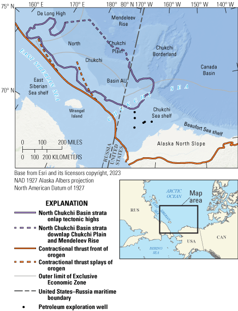
Map showing the location of the North Chukchi Basin Assessment Unit (AU), prominent physiographic features, United States–Russia maritime boundary, outer limits of the Exclusive Economic Zone of the United States and Russia (U.S. Department of State, 2023), and pertinent exploration wells.
The assessment area contains sparse subsurface data, and the nearest petroleum exploration wells lie 20 to 100 mi (30 to 160 km) south and southeast of the basin on the U.S. Chukchi Sea shelf (fig. 1). The primary data used for interpreting the geological framework for this assessment comprise about 20,000 mi (32,000 km) of multichannel, two-dimensional seismic reflection data obtained from a variety of commercial, academic, and public sources. Although these seismic data cover the entire basin, data density is greatest in the United States EEZ and significantly lower elsewhere. Seismic data were supplemented by interpretation of regionally gridded gravity and magnetic anomaly maps (Gaina and others, 2011) covering the entire region.
Geological Framework
The North Chukchi Basin formed by rifting between continental crust of the Chukchi Sea and East Siberian Sea shelves on the south and the Chukchi Borderland (continental crust), Chukchi Plain (oceanic crust), and Mendeleev Rise (High Arctic Large Igneous Province) on the north. Rifting likely occurred from the Middle or Late Jurassic to Early Cretaceous (Neocomian) (Granath and others, 2015; Ilhan and Coakley, 2018; Drachev and others, 2018; Nikishin and others, 2019). Interpretation of south–north seismic profiles across the basin suggests the southern basin margin is analogous to attenuated continental crust on magma-poor rifted margins, and the northeastern (Chukchi Borderland) and northwestern (Chukchi Plain and Mendeleev Rise) margins are analogous to magma-rich rifted margins (Pindell and others, 2014). The basin floor, on which the base of the sedimentary succession rests across most of the basin, is interpreted as exhumed mantle or highly attenuated lower crust (Granath and others, 2015; Drachev and others, 2018). The geologic history of the basin includes uplift and exhumation during Jurassic to Early Cretaceous rifting followed by collapse and subsidence during the Early Cretaceous through Cenozoic.
Boundaries of the North Chukchi Basin, defined herein for assessment purposes, are delineated by (1) strata that thin and pinch out by onlap onto rift margins on the west, south, east, and northeast and (2) strata that thin by downlap onto oceanic crust on the northwest (fig. 1). Basin-filling strata thicken abruptly from basin margins to a maximum of approximately 75,000 feet (ft; 23 km) along the basin axis as defined by the deepest time structure (fig. 2).
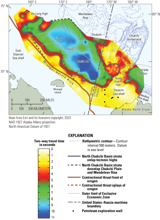
Time-depth structure map of base of sedimentary succession in the North Chukchi Basin Assessment Unit (AU) and adjacent areas. Grid scale shows two-way travel time in seconds; in other words, the time for a seismic wave to travel from source to reflective base of sedimentary succession and return to receiver. Grid scale is nonlinear, with increasing depth per unit increasing with time; maximum time of 11 seconds correlates to approximately 75,000 feet (23 kilometers) depth.
The basin fill comprises mainly Cretaceous and Cenozoic strata of the Brookian sequence (Houseknecht, 2022). Pre-Cretaceous strata of both the Ellesmerian (Triassic and older) and Beaufortian (Jurassic to Early Cretaceous [Neocomian]) sequences are truncated by erosion along the southern basin margin, as evident in seismic data, and are absent because of nondeposition on the northwestern basin margin.
Ages of the Cretaceous and Cenozoic strata in the U.S. Chukchi Sea shelf range from Aptian to Coniacian and from Paleocene to Oligocene, respectively, and are based on biostratigraphy, geochronology, and thermochronology from exploration wells and seafloor cores (Sherwood and others, 2002; Craddock and Houseknecht, 2016; Houseknecht and others, 2016; Homza and Bergman, 2019; Houseknecht, 2022). Across the entire shelf, Cretaceous and Cenozoic strata are separated by the “Mid-Brookian unconformity” (MBU), which occurs at the Cretaceous–Paleogene boundary (Homza and Bergman, 2019; Connors and Houseknecht, 2022). The MBU marks a pulse of contractional deformation across the northern U.S. Chukchi Sea shelf centered around the “North Chukchi High” (fig. 2), a basement uplift characterized by both south- and north-verging thrust faults and associated folds. Seismic data indicate the MBU also is present along the southern basin margin owing to uplift and exhumation along the Wrangel-Herald Arch (figs. 1, 2). Westward from the North Chukchi High and northward from the Wrangel-Herald Arch, the MBU grades to a correlative conformity in the deep depocenter west of the United States–Russia maritime boundary, where the stratigraphic succession appears to be conformable (in other words, no MBU). Farther basinward to the north, strata as young as Neogene and Quaternary are present on the modern shelf margin and marine slope (for example, Kumar and others, 2011; Hegewald and Jokat, 2013). Thus, the entire basin fill likely spans the Aptian to Quaternary with no unconformities other than sequence-bounding erosion attributed to fluctuations in relative sea level.
The entire Cretaceous to Cenozoic succession in the North Chukchi Basin comprises stacked clinothems in which clinoform dips indicate sediment routing from the south and southeast and dispersal generally northward. Likely provenance areas included the Chukotka Orogen in northeastern Siberia and the western Brooks Range Orogen in northwestern Alaska (Drachev and others, 2018; Craddock and others, 2018). Sediment dispersal within the basin includes progradation of curvilinear shelf margins and onlap of highstanding bathymetric elements such as the southern Chukchi Borderland in the northeast and the De Long High in the northwest (fig. 2).
Petroleum source rocks in the basin are inferred to be present in Cretaceous to Paleogene strata comprising the Hauterivian informal pebble shale unit, Barremian to Turonian Hue Shale, and upper Paleocene to middle Eocene strata coeval to distal organic-rich strata present across much of the Arctic Ocean (Houseknecht, 2022). Figure 2 in Houseknecht (2022) shows known stratigraphic distribution of Cretaceous to Paleogene source rocks. Pseudowells were generated at intersections of seismic lines across much of the basin. Seismic times for key horizons were converted to depths using the time-depth curves of Grantz and others (1990), augmented by more recent, proprietary velocity logs from deep exploration wells on the Chukchi and Beaufort Seas shelves (fig. 1). Burial history modeling of pseudowells indicates that the Cretaceous source-rock intervals across much of the basin are characterized by extreme burial depths and levels of thermal maturity in which gas likely is the only thermally stable hydrocarbon (in other words, within the “gas window”); only the inferred Paleogene source-rock interval was buried into the oil window but not into the gas window across much of the basin.
Widespread gas leakage from depths in excess of 20,000 ft (6.1 km) is suggested by (1) the presence of abundant gas chimneys emanating from the deep basin in seismic images, (2) the presence of a zone of anomalously low seismic velocity suggesting the top of overpressure, and burial history models of pseudowells indicating (3) pervasive overmature strata (gas window and higher thermal maturity) and (4) pervasive overpressure in the deep basin. The top of the gas window and higher thermal maturity as well as the top of overpressure generally occur between 15,000 to 20,000 ft (4,500 to 6,100 meters [m]). It is inferred that the deep basin contains overpressured, basin-centered gas that is leaking upward via all available migration pathways.
Assessment inputs, including the number and size of potential accumulations (table 1; Houseknecht and others, 2024), were largely based on amplitude anomalies in seismic images. Anomalies are most commonly observed in shelf-margin topset, slope, and bottomset positions that suggest the presence of stratigraphic traps in deposits of outer shelf to lowstand delta, lower slope to incised slope-channel, and toe-of-slope to basin-floor fan facies. Anomalies also were observed in structural trap geometries, including rotated normal fault blocks and, in the eastern end of the basin, contractional fold-and-thrust belt geometries. Near the western end of the basin, amplitude anomalies were observed in apparent combination traps comprising rotated normal fault blocks with truncated strata forming traps that involve angular unconformities.
Undiscovered Resources Summary
Undiscovered, technically recoverable resources in conventional accumulations of a minimum size of 50 million barrels of oil (MMBO) or 300 billion cubic feet of gas (BCFG) were estimated for the North Chukchi Basin. Input data and results of the USGS assessment are shown in tables 1 and 2 and Houseknecht and others (2024). The fully risked, estimated mean total resources for the North Chukchi Basin include the following: 1,759 MMBO, with an F95 to F5 range from 903 to 2,986 MMBO; 119,901 BCFG, with an F95 to F5 range from 69,118 to 188,959 BCFG; and 842 million barrels of natural gas liquids (MMBNGL), with an F95 to F5 range from 480 to 1,339 MMBNGL (table 2). Oil accumulations likely are limited to depths shallower than about 20,000 ft (6,100 m), whereas gas accumulations may occur at any depth and likely are the only hydrocarbons present at depths greater than about 20,000 ft (6,100 m).
Table 2.
Results for one conventional assessment unit in the North Chukchi Basin.[Results shown are fully risked estimates. F95 represents a 95-percent chance of at least the amount tabulated; other fractiles are defined similarly. Gray shading indicates not applicable. MMBO, million barrels of oil; BCFG, billion cubic feet of gas; NGL, natural gas liquids; MMBNGL, million barrels of natural gas liquids]
For More Information
Assessment results are also available at the USGS Energy Resources Program website, https://www.usgs.gov/programs/energy-resources-program.
References Cited
Connors, C.D., and Houseknecht, D.W., 2022, Structural inheritance in the Chukchi Shelf, Alaska: Marine and Petroleum Geology, 17 p., accessed November 14, 2023, at https://doi.org/10.1016/j.marpetgeo.2022.105812.
Craddock, W.H., and Houseknecht, D.W., 2016, Cretaceous-Cenozoic burial and exhumation history of the Chukchi Shelf, offshore Arctic Alaska: AAPG Bulletin, v. 100, no. 1, p. 63–100, accessed November 14, 2023, at https://doi.org/10.1306/09291515010.
Craddock, W.H., Moore, T.E., O’Sullivan, P., Potter, C.J., and Houseknecht, D.W., 2018, Late Cretaceous–Cenozoic exhumation of the western Brooks Range, Alaska, revealed from apatite fission track data: Tectonics, v. 37, no. 12, p. 4714–4751, accessed November 14, 2023, at https://doi.org/10.1029/2018TC005282.
Drachev, S.S., Mazur, S., Campbell, S., Green, C., and Tishchenko, A., 2018, Crustal architecture of the East Siberian Arctic shelf and adjacent Arctic Ocean constrained by seismic data and gravity modeling results: Journal of Geodynamics, v. 119, p. 123–148, accessed November 14, 2023, at https://doi.org/10.1016/j.jog.2018.03.005.
Gaina, C., Werner, S.C., Saltus, R., Maus, S., and the CAMP-GM Group, 2011, Circum-Arctic mapping project—New magnetic and gravity anomaly maps of the Arctic, in Spencer, A.M., Embry, A.F., Gautier, D.L., Stoupakova, A.V., and Sørensen, K., eds., Arctic Petroleum Geology: Geological Society of London Memoirs 35, p. 39–48. [Also available at https://doi.org/10.1144/M35.3.]
Granath, J.W., McDonough, K.-J., Sterne, E.J., and Horn, B.W., 2015, Contrasting extensional basin styles and sedimentary fill across the eastern Russian Arctic shelf as imaged in crustal-scale PSDM reflection data: AAPG Search and Discovery, article 10811, 28 p. and slides, accessed November 14, 2023, at https://www.searchanddiscovery.com/pdfz/documents/2015/10811granath/ndx_granath.pdf.html.
Grantz, A., May, S.D., and Hart, P.E., 1990, Geology of the Arctic continental margin of Alaska, chap. 16 of The Arctic Ocean region, vol. L of The geology of North America: Boulder, Colo., Geological Society of America, p. 257–288. [Also available at https://doi.org/10.1130/DNAG-GNA-L.257.]
Hegewald, A., and Jokat, W., 2013, Tectonic and sedimentary structures in the northern Chukchi region, Arctic Ocean: Journal of Geophysical Research Solid Earth, v. 118, no. 7, p. 3285–3296, accessed November 14, 2023, at https://doi.org/10.1002/jgrb.50282.
Homza, T.X., and Bergman, S.C., 2019, A geologic interpretation of the Chukchi Sea Petroleum Province, offshore Alaska, USA: AAPG Memoir 119. [Also available at https://doi.org/10.1306/AAPG119.]
Houseknecht, D.W., 2022, Colville Foreland Basin and Arctic Alaska Prograded Margin Tectono-Sedimentary Elements, northern Alaska and southwestern Canada Basin, in Drachev, S.S., Brekke, H., Henriksen, E., and Moore, T.E., eds., Sedimentary successions of the Arctic region and their hydrocarbon prospectivity: Geological Society of London Memoirs 57, 19 p., accessed November 14, 2023, at https://doi.org/10.1144/m57-2018-65.
Houseknecht, D.W., Craddock, W.H., and Lease, R.O., 2016, Upper Cretaceous and Lower Jurassic strata in shallow cores on the Chukchi shelf, Arctic Alaska, in Dumoulin, J.A., ed., Studies by the U.S. Geological Survey in Alaska, vol. 15: U.S. Geological Survey Professional Paper 1814–C, 37 p., accessed November 14, 2023, at https://doi.org/10.3133/pp1814C.
Houseknecht, D.W., Mercier, T.J., and Schenk, C.J., 2024, National and Global Petroleum Assessment—North Chukchi Basin Province—Assessment unit boundaries, assessment input data, and fact sheet data tables: U.S. Geological Survey data release, https://doi.org/10.5066/P1O4VPJS.
Ilhan, I., and Coakley, B.J., 2018, Meso–Cenozoic evolution of the southwestern Chukchi Borderland, Arctic Ocean: Marine and Petroleum Geology, v. 95, p. 100–109, accessed November 14, 2023, at https://doi.org/10.1016/j.marpetgeo.2018.04.014.
Kumar, N., Granath, J.W., Emmet, P.A., Helwig, J.A., and Dinkelman, M.G., 2011, Stratigraphic and tectonic framework of the US Chukchi Shelf—Exploration insights from a new regional deep-seismic reflection survey: Geological Society of London Memoirs 35, p. 501–508. [Also available at https://doi.org/10.1144/M35.33.]
Nikishin, A.M., Startseva, K.F., Verzhbitsky, V.E., Cloetingh, S., Malyshev, N.A., Petrov, E.I., Posamentier, H., Freiman, S.I., Lineva, M.D., and Zhukov, N.N., 2019, Sedimentary basins of the East Siberian Sea and the Chukchi Sea region and the adjacent area of the Amerasia Basin—Seismic stratigraphy and stages of geological history: Geotektonika, v. 53, no. 6, p. 3–26, accessed January 9, 2020, at https://doi.org/10.31857/S0016-853X201963-26.
Pindell, J., Graham, R., and Horn, B., 2014, Rapid outer marginal collapse at the rift to drift transition of passive margin evolution, with a Gulf of Mexico case study: Basin Research, v. 26, no. 6, p. 701–725, accessed April 22, 2014, at https://doi.org/10.1111/bre.12059.
Sherwood, K.W., Johnston, P.P., Craig, J.D., Zerwick, S.A., Lothamer, R.T., Thurston, D.K., and Hurlbert, S.B., 2002, Structure and stratigraphy of the Hanna Trough, U.S. Chukchi Shelf, Alaska, in Miller, E.L., Grantz, A., and Klemperer, S.L., Tectonic evolution of the Bering Shelf-Chukchi Sea-Arctic Margin and adjacent landmasses: Geological Society of America Special Papers, v. 360, p. 39–66. [Also available at https://doi.org/10.1130/0-8137-2360-4.39.]
U.S. Department of State, 2023, Fact sheet—Announcement of U.S. extended continental shelf outer limits: U.S. Department of State, Office of the Spokesperson press release, December 19, 2023, accessed December 22, 2023, at https://www.state.gov/announcement-of-u-s-extended-continental-shelf-outer-limits-2/.
Disclaimers
Any use of trade, firm, or product names is for descriptive purposes only and does not imply endorsement by the U.S. Government.
Although this information product, for the most part, is in the public domain, it also may contain copyrighted materials as noted in the text. Permission to reproduce copyrighted items must be secured from the copyright owner.
Suggested Citation
Houseknecht, D.W., Markey, C.P., Mercier, T.J., Schenk, C.J., Connors, C.D., Gooley, J.T., Botterell, P.J., Smith, R.A., Rouse, W.A., and Garrity, C.P., 2024, Assessment of undiscovered oil and gas resources of the North Chukchi Basin, outer continental shelf of the Chukchi and East Siberian Seas, Arctic Ocean, 2023 (ver. 1.2, July 2024): U.S. Geological Survey Fact Sheet 2024–3015, 4 p., https://doi.org/10.3133/fs20243015.
ISSN: 2327-6932 (online)
ISSN: 2327-6916 (print)
Study Area
| Publication type | Report |
|---|---|
| Publication Subtype | USGS Numbered Series |
| Title | Assessment of undiscovered oil and gas resources of the North Chukchi Basin, outer continental shelf of the Chukchi and East Siberian Seas, Arctic Ocean, 2023 |
| Series title | Fact Sheet |
| Series number | 2024-3015 |
| DOI | 10.3133/fs20243015 |
| Edition | Version 1.0: May 2024; Version 1.1: June 2024; Version 1.2: July 2024 |
| Publication Date | May 29, 2024 |
| Year Published | 2024 |
| Language | English |
| Publisher | U.S. Geological Survey |
| Publisher location | Reston, VA |
| Contributing office(s) | Central Energy Resources Science Center, Eastern Energy Resources Science Center, Geology, Energy & Minerals Science Center |
| Description | Report: 4 p.; Data Release |
| Country | Russia, United States |
| Other Geospatial | Chukchi Sea, East Siberian Sea |
| Online Only (Y/N) | N |
| Additional Online Files (Y/N) | N |