

The 3D Elevation Program—Supporting Ohio’s Economy
Links
- Document: Report (1.12 MB pdf) , HTML , XML
- Download citation as: RIS | Dublin Core
Introduction
High-quality elevation data are proving to be a resource of great economic value in dealing with many important issues in Ohio. Current and accurate high-resolution elevation data support flood risk management, water quantity and quality assessment, precision farming, conservation planning, impervious-surface modeling, forest and other natural resources management, abandoned mine and geologic hazard assessment, karst mapping, and siting of wellhead pads for horizontal drilling. These data also support coastal zone management, traffic safety and preliminary engineering site-selection studies for transportation infrastructure, solar potential and other renewable energy planning, aviation safety, and identification of features of interest or concern such as archaeological sites and orphan oil and gas wells. Critical applications that meet the State’s management needs depend on light detection and ranging (lidar) data that provide a highly detailed three-dimensional (3D) model of the Earth’s surface and aboveground features.
The 3D Elevation Program (3DEP; refer to sidebar) is managed by the U.S. Geological Survey (USGS) in partnership with Federal, State, Tribal, U.S. territorial, and local agencies to acquire consistent lidar coverage at quality level 2 or better (table 1) to meet the many needs of the Nation and Ohio. The status of available and in-progress 3DEP baseline lidar data in Ohio is shown in figure 1. 3DEP baseline lidar data include quality level 2 or better, 1-meter or better digital elevation models, and lidar point clouds, and must meet the Lidar Base Specification version 1.2 (https://www.usgs.gov/3dep/lidarspec) or newer requirements. The National Enhanced Elevation Assessment (Dewberry, 2012) identified user requirements and conservatively estimated that availability of lidar data would result in at least $8.28 million in new benefits annually to the State. The top nine Ohio business uses for 3D elevation data, which are based on the estimated annual conservative benefits of 3DEP, are shown in table 2.
Table 1.
Data quality levels, pulse spacing, and pulse density. Quality level 2 or better lidar data meet 3DEP requirements.[Specifications for quality level 0 (QL0) are from Heidemann (2012, p. 3 and table 1); for quality levels 1 and 2, specifications are from Sugarbaker and others (2014, table 1). In the quality level column, QL0 represents the highest level of quality. RMSEz, root mean square error in the elevation (z) dimension; cm, centimeter; m, meter; pls/m2, first return pulses per square meter; ≤, less than or equal to; ≥, greater than or equal to]
Table 2.
Conservative benefits estimates for the top nine Ohio business uses of the proposed 3DEP data identified in the National Enhanced Elevation Assessment (Dewberry, 2012).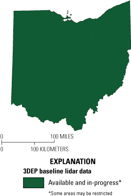
Map of Ohio showing status of 3D Elevation Program (3DEP) baseline lidar data as of June 2023. Visit https://www.usgs.gov/NationalMap/LidarExplorer to find and download currently available data.
Status of 3DEP in Ohio
The State of Ohio has been very progressive in the coordination, development, and use of framework spatial data, including lidar-based elevation data. In 2019, the Ohio Statewide Imagery Program (OSIP) (Ohio Department of Administrative Services, 2020) began to update and improve statewide lidar-based elevation data in cooperation with 3DEP by collecting high-resolution, quality level 1 data. That effort was completed in 2023.
Water Supply and Quality
The contemporary and high-resolution, quality level 1 data acquired through 3DEP will be used to assess the impact and mitigation of multiple runoff issues in the Lake Erie watershed, including non-point-source pollution of lakes, rivers, and wetlands. These assessments are necessary to address water quality threats that have affected municipal public water supplies, hindered recreation, and impaired biologic productivity in the region.
Infrastructure and Construction Management
To support the Blueprint Columbus initiative (City of Columbus, Ohio, 2019), the City of Columbus obtained high-resolution quality level 0 data through 3DEP and OSIP for its multi-county service area. These higher resolution and more accurate data (fig. 2) for the entire Columbus metropolitan area are used to support infrastructure mapping for the city’s hydraulic models related to stormwater drainage improvements, correction of street-gutter flow paths, reduction of surface flooding and ponding, and reduction of pollution loads. This effort provides important base data required for Blueprint Columbus.
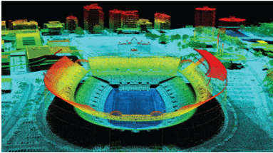
Image derived from lidar point-cloud of Ohio Stadium and vicinity in Columbus, Ohio. Colors represent elevation above the ground surface, with lowest areas shown in dark blue and higher elevations represented by warmer colors. Point-cloud and bare-earth data are important in analyses for water supply and quality, infrastructure and construction management, natural resources conservation, and geologic resource assessment and hazard mitigation. Image courtesy of the Ohio Geographically Referenced Information Program (OGRIP).
Natural Resources Conservation
The Ohio Department of Natural Resources (ODNR) Orphan Well Program (Ohio Department of Natural Resources, 2020) was established in 1977 to plug orphan wells, which are abandoned oil and natural gas wells that have not been plugged properly and do not have an owner who could pay to do that work. Orphan wells can leak oil, natural gas, and brine into surrounding water and soil. ODNR’s program has plugged more than a thousand wells, and a robust plan is in place to use new quality level 1 lidar data to help identify previously unknown gas and oil well locations.
Geologic Resource Assessment and Hazard Mitigation
Ohio’s mineral industries produced almost $1.5 billion worth of geologic commodities in 2021, according to a report from ODNR (Ohio Department of Natural Resources, 2022). The report stated that the total value of all nonfuel industrial minerals produced exceeded $1 billion for the eighth straight year.
3DEP by the Numbers: Ohio
Expected annual benefits: $8.28 million
Quality levels 1 and 2 completion1 : 100 percent
Quality level 0 collection is at additional cost.
Dense vegetation can make geologic mapping difficult and obscure potentially hazardous areas. Lidar digital terrain (bare-earth) models using quality level 1 data can be used to improve geologic mapping; locate and assess mineral resources, abandoned mine lands, active landslides, and preexisting landslides that are susceptible to reactivation; and detect sinkhole features that are too small or too new to have been identified in previous elevation collections.
3D Elevation Program (3DEP)
The 3D Elevation Program is managed by the U.S. Geological Survey (USGS) on behalf of the community of Federal, State, Tribal, local, and other partners and users of elevation data. In response to growing needs for high-quality elevation data, the goal of 3DEP is to complete acquisition of nationwide light detection and ranging (lidar) data (interferometric synthetic aperture radar [IfSAR] data in Alaska) to provide the first-ever national baseline of consistent, high-resolution topographic elevation data—both bare-earth digital elevation models and 3D point clouds.
Benefits
-
• Economies of scale by acquiring data for larger areas.
-
• Predictable and flexible Federal investments that reduce costs and allow better planning.
-
• Consistent national coverage that provides data for applications that span project, jurisdictional, and watershed boundaries.
-
• Simplified data acquisition that provides contracts, project management, quality assurance, and published data specifications.
-
• National benefits of $690 million per year conservatively, with the potential to generate $13 billion per year in additional benefits through applications that span the economy (Dewberry, 2012).
High-Quality Data and Products
3DEP lidar data provide coverage with a minimum of two points per square meter and a vertical error not to exceed 10 centimeters, measured as root mean square error in the elevation (z) dimension (RMSEz) (table 1). 3DEP baseline lidar data products include all data points collected (point clouds) and bare-earth digital elevation models with a 1-meter or better resolution. The USGS integrates the elevation data into The National Map. Data are available free of charge and without use restrictions. To download 3DEP products visit https://apps.nationalmap.gov/downloader/.
Ways to Participate
Participation in 3DEP is open to Federal, State, Tribal, U.S. territorial, and local government partners, as well as private sector partners, and offers the option to acquire higher quality data. Partners may contribute funds toward projects managed by the USGS, or they may receive cooperative funds to manage their own projects. An annual Data Collaboration Announcement is the mechanism used to establish partner agreements. Organizations and the private sector may contribute existing data that meet 3DEP requirements. For more information refer to the 3DEP website at https://www.usgs.gov/3DEP/collaborate/.
References Cited
City of Columbus, Ohio, 2019, Blueprint Columbus: City of Columbus web page, accessed August 28, 2023, at https://www.columbus.gov/Services/Public-Utilities/About-Public-Utilities/Office-of-Sustainability/Blueprint-Columbus.
Dewberry, 2012, National Enhanced Elevation Assessment final report (revised March 29, 2012): Fairfax, Va., Dewberry, 84 p. plus appendixes, accessed August 28, 2023, at https://www.dewberry.com/services/geospatial/national-enhanced-elevation-assessment.
Heidemann, H.K., 2012, Lidar base specification (ver. 1.2, November 2014): U.S. Geological Survey Techniques and Methods, book 11, chap. B4, 67 p. with appendixes, accessed August 28, 2023, at https://doi.org/10.3133/tm11B4.
Ohio Department of Administrative Services, [2020], Ohio Statewide Imagery Program (OSIP): Ohio Department of Administrative Services web page, accessed August 28, 2023, at https://das.ohio.gov/technology-and-strategy/ogrip/projects/osip.
Ohio Department of Natural Resources [ODNR], 2020, Orphan Well Program: ODNR, Division of Oil and Gas Resources web page, accessed October 26, 2020, at https://ohiodnr.gov/discover-and-learn/safety-conservation/about-ODNR/oil-gas/orphan-wells.
Ohio Department of Natural Resources [ODNR], 2022, Ohio’s mineral resources valued at nearly $1.5 billion in 2021: ODNR news article, November 15, 2022, accessed August 28, 2023, at https://ohiodnr.gov/discover-and-learn/safety-conservation/about-ODNR/news/mineral-resources-2021.
Sugarbaker, L.J., Constance, E.W., Heidemann, H.K., Jason, A.L., Lukas, V., Saghy, D.L., and Stoker, J.M., 2014, The 3D Elevation Program initiative—A call for action: U.S. Geological Survey Circular 1399, 35 p., accessed August 28, 2023, at https://doi.org/10.3133/cir1399.
For Further Information:
Director, National Geospatial Program
U.S. Geological Survey, MS 511
12201 Sunrise Valley Drive
Reston, VA 20192
Email: 3DEP@usgs.gov
USGS National Map Liaison: Cynthia Rachol
Email: crachol@usgs.gov
Disclaimers
Any use of trade, firm, or product names is for descriptive purposes only and does not imply endorsement by the U.S. Government.
Although this information product, for the most part, is in the public domain, it also may contain copyrighted materials as noted in the text. Permission to reproduce copyrighted items must be secured from the copyright owner.
Suggested Citation
Hickman, C.E., 2024, The 3D Elevation Program—Supporting Ohio's economy: U.S. Geological Survey Fact Sheet 2024–3017, 2 p., https://doi.org/10.3133/fs20243017.
ISSN: 2327-6932 (online)
ISSN: 2327-6916 (print)
Study Area
| Publication type | Report |
|---|---|
| Publication Subtype | USGS Numbered Series |
| Title | The 3D Elevation Program—Supporting Ohio's economy |
| Series title | Fact Sheet |
| Series number | 2024-3017 |
| DOI | 10.3133/fs20243017 |
| Publication Date | June 06, 2024 |
| Year Published | 2024 |
| Language | English |
| Publisher | U.S. Geological Survey |
| Publisher location | Reston, VA |
| Contributing office(s) | National Geospatial Program |
| Description | 2 p. |
| Country | United States |
| State | Ohio |
| Online Only (Y/N) | N |
| Additional Online Files (Y/N) | N |