

Assessment of Conventional and Continuous Oil and Gas Resources in the Lewis Shale in the Southwestern Wyoming Province, Wyoming and Colorado, 2023
Links
- Document: Report (1.57 MB pdf) , HTML , XML
- Data Release: USGS data release - USGS National and Global Oil and Gas Assessment Project—Southwestern Wyoming Province, Lewis Shale Conventional and Continuous Assessment Unit Boundaries, Assessment Input Data, and Fact Sheet Data Tables
- NGMDB Index Page: National Geologic Map Database Index Page (html)
- Download citation as: RIS | Dublin Core
Abstract
Using a geology-based assessment methodology, the U.S. Geological Survey estimated undiscovered, technically recoverable mean conventional and continuous resources of 294 million barrels of oil and 11 trillion cubic feet of gas in the Lewis Shale in the Southwestern Wyoming Province, Wyoming and Colorado.
Introduction
The U.S. Geological Survey (USGS) assessed undiscovered, technically recoverable conventional and continuous (unconventional) oil and gas resources in the Late Cretaceous (Campanian-Maastrichtian) Lewis Shale in the eastern portion of the Southwestern Wyoming Province in Wyoming and Colorado (figs. 1–2). The Lewis Shale is part of the Cretaceous–Cenozoic Composite Total Petroleum System (TPS), and it is bound to the north, south, and east by uplift, and to the west by depositional pinch-out (figs. 1–2).

Map showing one conventional and two continuous assessment units (AUs) in the Lewis Shale within the Cretaceous–Cenozoic Composite Total Petroleum System of the Southwestern Wyoming Province.
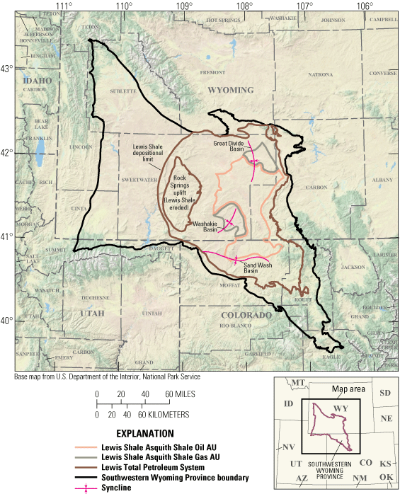
Map showing two continuous assessment units (AUs) for the Asquith marker in the Lewis Shale within the Cretaceous–Cenozoic Composite Total Petroleum System of the Southwestern Wyoming Province.
The Lewis Shale was previously assessed by the USGS in 2005 (Hettinger and Roberts, 2005), and one conventional and one continuous assessment unit (AU) were defined at that time. One conventional and four continuous AUs were defined for this assessment of potential hydrocarbon resources in the Lewis Shale (figs. 1–2): a Lewis Shale Conventional Gas AU, a Lewis Shale Northern Continuous Gas AU, a Lewis Shale Southern Continuous Gas AU, a Lewis Shale Asquith Shale Oil AU, and a Lewis Shale Asquith Shale Gas AU. Multiple criteria were used to define these AUs, including spatial and temporal lithologic variability and thickness, reservoir architecture, depositional environment, and thermal maturity.
Geologic Summary
The Lewis Shale comprises nearshore- to deep-marine sandstones, siltstones, and mudstones, and produces abundant natural gas and lesser amounts of oil from low porosity, low permeability clastic reservoirs. The Lewis overlies the marginal marine Almond Formation of the Mesaverde Group and is overlain by the shallow marine Fox Hills Sandstone. Regionally, the Lewis interfingers with both formations and represents time-equivalent, genetically related, marine strata.
The Lewis Shale is subdivided into three members herein, in ascending order (fig. 3): a mudstone-dominated, informal lower member; a sandstone-dominated, formally named, middle Dad Sandstone Member; and a silt- and mudstone-dominated, informal upper member (Gill and others, 1970; Pyles and Slatt, 2000). The top of the lower member is defined by a regionally extensive, high gamma ray zone that is informally known as the Asquith marker (fig. 3; Pasternack, 2005, after Asquith, 1970). The Asquith marker is an organic-rich, black shale that is interpreted as a third-order condensed section marking the maximum flooding surface of the Lewis (McMillen and Winn, 1991; Pyles and Slatt, 2000). This zone is greater than 30 feet (ft) thick in the east-central portion of the TPS (Hearon, 2023a) and total organic carbon content averages 3.2 weight percent. Along with coal beds in the underlying Almond Formation, the Asquith zone is likely a secondary source of hydrocarbons within the Lewis, yet this interval has had limited exploration as a self-sourced, continuous reservoir. For more detailed information on the regional geology of the Lewis Shale, refer to Hearon (2023b).

Type log image of the Barrel Spring Unit 15-1 well (S15, T16N, R93W), which highlights the stratigraphy of the Lewis Shale and associated formations. GR, gamma ray in American Petroleum Institute (API) units; ILD, deep resistivity in ohm-meters.
Total Petroleum System and Assessment Units
The USGS defined one conventional and four continuous AUs within the Cretaceous–Cenozoic Composite TPS (table 1). The outer boundaries of the Lewis Shale Conventional Gas AU are defined by either uplift or depositional pinchout of the Lewis Shale (figs. 1–2). The inner boundaries are defined by the 0.8 percent modeled vitrinite reflectance (Ro) thermal maturity line for gas. An Ro value of 0.8 percent was used to define the AUs because coal beds within the Almond Formation are the likely primary gas source. In general, Lewis fields within the Lewis Shale Conventional Gas AU have normal reservoir pressures, average porosities greater than 10 percent, average permeabilities greater than 0.1 millidarcies, and distinct gas-water contacts. In contrast, the Lewis Shale Northern and Southern Continuous Gas AUs are defined by the area where Ro is greater than 0.8 percent thermal maturity. In general, fields in the continuous AUs have overpressured reservoirs, average porosities less than 10 percent, average permeabilities less than 0.1 millidarcies, and no defined gas-water contacts.
Table 1.
Key input data for five assessment units in the Lewis Shale, Southwestern Wyoming Province.[The average EUR input is the minimum, median, maximum, and calculated mean. Gray shading indicates not applicable. AU, assessment unit; %, percent; EUR, estimated ultimate recovery; MMBO, million barrels of oil; BCFG, billion cubic feet of gas]
The Lewis Shale Northern and Southern Continuous Gas AUs are delineated in the north and south by uplift, respectively, and in the west and east by the modeled 0.8 percent Ro thermal maturity line for gas. These two continuous gas AUs are separated by a change in the interpreted depositional environment and architecture of the clastic reservoirs. Specifically, the boundary between these AUs is defined where there is an inferred paleo-shelf break. Sand bodies in the Lewis Shale Northern Continuous Gas AU are relatively smaller (less than 100 ft thick), widely distributed, and are interpreted as shelf, delta front, and (or) prodelta deposits. Conversely, sand bodies in the Lewis Shale Southern Continuous Gas AU are relatively larger (greater than 100 ft thick), are successively stacked on one another, and are interpreted as basin-floor fan deposits. Additionally, the Asquith marker markedly thins toward the boundary between the Lewis Shale Northern and Southern Continuous Gas AUs (Hearon, 2023a). Collectively, these data indicate a distinct change in stratigraphic architecture and depositional environments at this boundary.
The Lewis Shale Asquith Shale Oil AU is defined in the east by the modeled 0.6 percent Ro thermal maturity line for oil, in the south, west, and northwest by a 10-foot thickness minimum, and in the southwest and north by the 1.3 percent Ro thermal maturity line for gas. The Lewis Shale Asquith Shale Gas AU is split between a northern and southern area, representing locations in the Great Divide Basin and Washakie Basin, respectively. Both areas are bounded by either the 1.3 percent Ro thermal maturity line for gas or by a 10-foot thickness minimum.
Assessment input data are summarized in table 1 and in Hearon (2024). Only two wells within the Cretaceous–Cenozoic Composite TPS have targeted the Asquith marker within the Lewis Shale Asquith Shale Oil AU, and none have targeted the Asquith marker within the Lewis Shale Asquith Shale Gas AU (IHS Markit, 2022). As a result, there were insufficient production data to calculate estimated ultimate recoveries. Because of robust similarities in total organic carbon content, hydrogen index, oxygen index, low carbonate content, age, and location, data from the Mowry Shale in the Powder River Basin were used as analogs for the assessment of continuous resources in the Lewis Shale Asquith Shale Oil and Shale Gas AUs.
Undiscovered Resources Summary
The USGS quantitatively assessed oil and gas resources in one conventional and four continuous AUs in the Lewis Shale in the Southwestern Wyoming Province (table 2). The fully risked, estimated mean totals are 294 million barrels of oil (MMBO) with an F95–F5 fractile range from 83 to 556 MMBO; 11,207 billion cubic feet of gas (BCFG) with an F95–F5 range from 3,444 to 19,705 BCFG; and 338 million barrels of natural gas liquids (MMBNGL) with an F95–F5 range from 103 to 591 MMBNGL.
Table 2.
Results for five assessment units of the Lewis Shale, Southwestern Wyoming Province.[Results shown are fully risked estimates. F95 represents a 95-percent chance of at least the amount tabulated; other fractiles are defined similarly. Gray shading indicates not applicable. MMBO, million barrels of oil; BCFG, billion cubic feet of gas; NGL, natural gas liquids; MMBNGL, million barrels of natural gas liquids]
For More Information
Assessment results and methods information are also available at the USGS Energy Resources Program website at https://www.usgs.gov/programs/energy-resources-program.
Lewis Shale Assessment Team
Jane S. Hearon, Christopher J. Schenk, Thomas M. Finn, Benjamin G. Johnson, Sarah E. Gelman, Jenny H. Lagesse, Cheryl A. Woodall, Tracey J. Mercier, Heidi M. Leathers-Miller, Kira K. Timm, Ronald M. Drake II, Andrea D. Cicero, Geoffrey S. Ellis, Michael H. Gardner, Phuong A. Le, and Scott S. Young
References Cited
Asquith, D.O., 1970, Depositional topography and major marine environments, Late Cretaceous, Wyoming: AAPG Bulletin, v. 54, no. 7, p. 1184–1224, accessed February 21, 2024, at https://doi.org/10.1306/5D25CBB3-16C1-11D7-8645000102C1865D.
Gill, J.R., Merewether, F.A., and Cobban, W.A., 1970, Stratigraphy and nomenclature of some Upper Cretaceous and lower Tertiary rocks in south-central Wyoming: U.S. Geological Survey Professional Paper 667, 53 p., accessed February 21, 2024, at https://doi.org/10.3133/pp667.
Hearon, J.S., 2023a, Digital stratigraphic and structural grids of the Cretaceous Lewis Shale in the eastern part of the Southwestern Wyoming Province, Wyoming and Colorado: U.S. Geological Survey data release, accessed March 25, 2024, at https://doi.org/10.5066/P9NAFL9H.
Hearon, J.S., 2023b, Stratigraphic cross sections of the Lewis Shale in the eastern part of the Southwestern Wyoming Province, Wyoming and Colorado: U.S. Geological Survey Scientific Investigations Map 3511, 1 sheet, 5-p. pamphlet, accessed March 25, 2024, at https://doi.org/10.3133/sim3511.
Hearon, J.S., 2024, USGS National and Global Oil and Gas Assessment Project—Southwestern Wyoming Province, Lewis Shale conventional and continuous assessment unit boundaries, assessment input data, and fact sheet data tables: U.S. Geological Survey data release, https://doi.org/10.5066/P9GKOC1H.
Hettinger, R.D., and Roberts, L.N.R., 2005, Lewis Total Petroleum System of the Southwestern Wyoming Province, Wyoming, Colorado, and Utah, chap. 9 of U.S. Geological Survey Southwestern Wyoming Province Assessment Team, comps., Petroleum systems and geologic assessment of oil and gas in the Southwestern Wyoming Province, Wyoming, Colorado, and Utah (ver. 1): U.S. Geological Survey Digital Data Series DDS–69–D, 39 p., 1 CD-ROM.
IHS Markit, 2022, Enerdeq US well history and production database: Englewood, Colo., IHS Markit, accessed December 2022 at http://www.ihsenergy.com. [Available from IHS Markit, 15 Inverness Way East, Englewood, CO 80112.]
McMillen, K.J., and Winn, R.D., Jr., 1991, Seismic facies of shelf, slope, and submarine fan environments of the Lewis Shale, Upper Cretaceous, Wyoming, in Weimer, P., and Link, M.H., eds., Frontiers in sedimentary geology—Seismic facies and sedimentary processes of submarine fans and turbidite systems: New York, Springer-Verlag, p. 273–287. [Also available at https://doi.org/10.1007/978-1-4684-8276-8_14.]
Pyles, D.R., and Slatt, R.M., 2000, A high-frequency sequence stratigraphic framework for shallow through deep-water deposits of the Lewis Shale and Fox Hills Sandstone, Great Divide and Washakie Basins, Wyoming, in Weimer, P., ed., Deep-water reservoirs of the world—Gulf Coast Section Society of Economic Paleontologists and Mineralogists Foundation, 20th annual Bob F. Perkins Research Conference, December 3–6, 2000, Houston, Texas: SEPM Society for Sedimentary Geology, p. 836–861, accessed February 21, 2024, at https://doi.org/10.5724/gcs.00.15.0836.
Disclaimers
Any use of trade, firm, or product names is for descriptive purposes only and does not imply endorsement by the U.S. Government.
Although this information product, for the most part, is in the public domain, it also may contain copyrighted materials as noted in the text. Permission to reproduce copyrighted items must be secured from the copyright owner.
Suggested Citation
Hearon, J.S., Schenk, C.J., Finn, T.M., Johnson, B.G., Gelman, S.E., Lagesse, J.H., Woodall, C.A., Mercier, T.J., Leathers-Miller, H.M., Timm, K.K., Drake, R.M., II, Cicero, A.D., Ellis, G.S., Gardner, M.H., Le, P.A., and Young, S.S., 2024, Assessment of conventional and continuous oil and gas resources in the Lewis Shale in the Southwestern Wyoming Province, Wyoming and Colorado, 2023: U.S. Geological Survey Fact Sheet 2024–3025, 4 p., https://doi.org/10.3133/fs20243025.
ISSN: 2327-6932 (online)
Study Area
| Publication type | Report |
|---|---|
| Publication Subtype | USGS Numbered Series |
| Title | Assessment of conventional and continuous oil and gas resources in the Lewis Shale in the Southwestern Wyoming Province, Wyoming and Colorado, 2023 |
| Series title | Fact Sheet |
| Series number | 2024-3025 |
| DOI | 10.3133/fs20243025 |
| Publication Date | July 31, 2024 |
| Year Published | 2024 |
| Language | English |
| Publisher | U.S. Geological Survey |
| Publisher location | Reston VA |
| Contributing office(s) | Central Energy Resources Science Center |
| Description | Report: 4 p.; Data Release |
| Country | United States |
| State | Colorado, Wyoming |
| Online Only (Y/N) | Y |